APRIL 2019: Warm & Muggy WX to End The Month

General Weather Discussions and Analysis
User avatar
srainhoutx
Site Admin
Site Admin
Posts: 19620
Joined: Tue Feb 02, 2010 2:32 pm
Location: Maggie Valley, NC
Contact:

Friday morning Weather Briefing from Jeff:

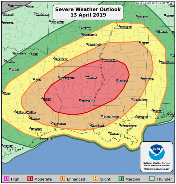
Significant severe weather outbreak likely on Saturday across east TX and LA including the potential for large damaging tornadoes.

Strong to severe thunderstorms possible over SE TX N of US 59 on Saturday.

Surface cold front has pushed into the Gulf of Mexico this morning allowing a much drier air mass to filter into the region. SW flow aloft is starting to overrun the cool and dry air at the surface and radar is showing a few showers around Matagorda Bay. A potent storm system over the SW US will eject across TX on Saturday and result in a significant severe weather outbreak.

Surface front over the Gulf will begin to back northward this afternoon as a warm front as surface pressure fall over NW TX ahead of the approaching upper level trough. Not expecting much shower activity today, but increasing lift tonight will likely result in showers developing and moving northward off the Gulf. Surface warm front placement will be critical on Saturday for severe weather. Currently expect the warm front to move northward and reach US 59 by early Saturday and then a line from College Station to Lake Livingston by early afternoon. Low level winds will be backed out of the E/ESE near the warm front and then overrun by WSW/SW winds around 5000 ft resulting in significant wind shear through the lowest part of the air column. Instability rapidly increases Saturday with CAPES values of 1000-2000 J/kg over the region. As lift increases from the approaching upper level trough and focuses along the retreating warm front severe thunderstorms will develop. Wind shear supports updraft rotation and think the primary mode will be supercells along the warm front with a very large hail and tornado risk. Will focus the highest risk along and N of HWY 105 and really more toward Lake Livingston with the best chances for tornadoes.

South of the warm front, the warm sector air mass will be unstable, but a weak capping inversion will advect into the region from the SW resulting in a fairly sharp cut off in the rain and thunderstorm chances. Severe thunderstorms will be possible in the warm sector south of the warm front and ahead of an afternoon cold frontal passage…mainly along and N of US 59. South of US 59, think the air mass will remain capped and only showers will be possible across Jackson, Matagorda, and Brazoria Counties. Severe threat in the warm sector is more conditional on Saturday and will require ingredients to come together at the right time. A review of the short range models show a line of storms, and line segments moving across the area from WNW to ESE Saturday afternoon and think some of these storms could become severe with large hail and damaging winds the main threats. Any isolated discrete cell that can develop in the warm sector could become tornadic, but think the highest tornado threat will focus along the warm front which by Saturday afternoon will be NE of our area.

As far as rainfall…fast overall system and cell motions should negate much of a flood threat. Maximum totals of 1-2 inches N of HWY 105 with amounts of .50 to 1 inch south of HWY 105 to US 59 and then less than .50 of an inch S of US 59 across the coastal counties.

NOTE: should the surface warm front be slower in lifting northward early Saturday, a much greater severe and tornado risk would encompass a larger area of SE TX. The movement of the warm front will need to be monitored closely for any refinements of the risks over our area.

SPC Saturday Severe Weather Outlook:
04122019 Jeff untitled.png
[/i]
Carla/Alicia/Jerry(In The Eye)/Michelle/Charley/Ivan/Dennis/Katrina/Rita/Wilma/Humberto/Ike/Harvey

Member: National Weather Association
Facebook.com/Weather Infinity
Twitter @WeatherInfinity
User avatar
tireman4
Global Moderator
Global Moderator
Posts: 4516
Joined: Wed Feb 03, 2010 9:24 pm
Location: Humble, Texas
Contact:

000
FXUS64 KHGX 121505
AFDHGX

Area Forecast Discussion
National Weather Service Houston/Galveston TX
1005 AM CDT Fri Apr 12 2019

.UPDATE...
The weak cold front that stalled out across SE TX yesterday, is
continuing to wobble N-S and washout. Currently, this boundary is
hung up along the coast, with dewpoints north of this line in the
middle 40s, and to the south in the mid 60s to low 70s. Cloud cover
remains overhead of this stalled boundary, and should thicken and
spread further inland through the afternoon hours as winds turn more
onshore and Gulf moisture is advected across the region. As a
result, also adjusted high temperatures for today down a few
degrees, forecasted to reach into the mid 70s to low 80s area wide.

Radar imagery this morning is showing some returns along the coast
along the stationary front. Went ahead and increased PoPs to account
for the slight chance for some scattered showers or drizzle
developing along this feature. An isolated thunderstorm or two
also developed just south of the forecast area over Calhoun
County, so decided to add in isolated thunder over the areas that
could see the better chances of rain. This stationary boundary
will transition into a warm front and advance northward across SE
TX late this afternoon and into tonight. Therefore, the chance for
showers and thunderstorms increases as we move into the evening
hours, out ahead of our next storm system which should be arriving
early Saturday.

Hathaway

&&

.PREV DISCUSSION... /ISSUED 734 AM CDT Fri Apr 12 2019/

AVIATION...
The cold front has worked its way just off the coast at sunrise
with thick cirrus and northeasterly surface winds in its wake.
VFR through the day as cirrus streams across within the mid layer
southwesterly flow. Low level winds will veer more easterly
through the early afternoon and stick to a more southeasterly
direction by sunset. Afternoon SCT-BKN VFR ceilings will begin to
develop and then lower into MVFR from the late afternoon through
early evening hours. Higher source of moisture from the Gulf will
surge onshore tonight and proceed to lower more southern terminal
ceilings down into IFR shortly after midnight...further inland
around midnight Saturday. As the lower few thousand feet saturate
up underneath a mid-level inversion... frictional streamer showers
will begin to pass over tonight and will likely increase in
frequency Saturday morning. There will be increasing chances for
the development of thunderstorms during the late Saturday morning
hours. 31

PREV DISCUSSION... /ISSUED 413 AM CDT Fri Apr 12 2019/

DISCUSSION...
Cold front has made it to the coast with north to northeast winds now
across the entire area. Temperatures are currently in the 50s inland
and in the 60s near/along the coast. Mostly cloudy to cloudy skies could
become partly cloudy for a little bit today as temperatures warm into
a mid/upper 70s to lower 80s range and winds come back around to the
east as the front begins to work its way back inland as a warm front.
Rain chances begin to increase tonight as moisture levels and instability
begin to rise while the next storm system approaches the state from
the west. This system moves across the state on Saturday and bring our
area its best rain chances. SPC`s Day 2 Outlook has Southeast Texas
severe risk areas ranging from marginal across our western counties
to enhanced across our far northeast counties. While parts of our area
are at risk for some strong/severe storms, models are generally showing
the greatest risk just off to our northeast where SPC`s moderate risk
is found. Once we get this system through the area on Saturday, a drier
and cooler pattern can be expected beginning Saturday night and continuing
through Monday as surface high pressure builds into the state and then
moves off to the east. This will allow for an onshore flow to return
to the area on Monday and strengthen as we head on into Tuesday and
Wednesday as the next storm system organizes off to our northwest.
The area`s next best rain chances look to be setting up Tuesday night
and Wednesday. 42

MARINE...
Long period swell has kept seas up under very weak winds. Swell is
forecast to subside with seas and their associated period falling
through the day. A near coastal morning cold front will turn
nearshore winds north-northeast with more variable early day
offshore winds backing around to a easterly direction by mid day.
Rio Grande Valley lowering pressures will strengthen and back winds
more southerly over 3 to 4 foot significant wave heights this
afternoon. Southeasterly winds will reach Caution levels this
evening...Gulf Advisory winds early Saturday. The development,
approach and northeastern passage of a Southern Plains upper trough
and eastern Texas surface low will increase Saturday`s shower and
storm chances. Winds along the backside of this system will veer
around to the northwest overnight Sunday morning...this offshore
flow will strengthen back to Advisory levels Sunday. As high
pressure travels from the Valley Sunday afternoon to southeastern
Louisiana Monday morning there will be a quick transition back to
onshore flow by sunrise Monday.

While probabilities of dense sea fog are low, rip currents and
higher coastal water levels will occur in the coming days. Recent
long period swell and near term strong onshore winds will increase
the threat for stronger late week rips. Saturday morning`s high
astronomical tide of 2 feet and greater than a foot surge above
these tides will produce 3.5 feet (above MLLW) coastal water levels.
The combination of this recent higher swell and today`s moderate
east to southeast fetch will push Gulf-facing water levels up to
levels that will create coastal wash over along the lower areas of
Highway 87 along the Bolivar Peninsula. 31

&&

.PRELIMINARY POINT TEMPS/POPS...
College Station (CLL) 78 66 78 48 69 / 10 60 90 10 0
Houston (IAH) 77 70 81 51 71 / 30 50 70 10 0
Galveston (GLS) 73 71 78 54 69 / 30 40 50 10 0

&&

.HGX WATCHES/WARNINGS/ADVISORIES...
TX...NONE.
GM...SMALL CRAFT SHOULD EXERCISE CAUTION until 1 PM CDT this
afternoon for the following zones: Coastal waters from High
Island to Freeport TX out 20 NM...Waters from Freeport to
Matagorda Ship Channel TX from 20 to 60 NM...Waters from
High Island to Freeport TX from 20 to 60 NM.

&&

$$

Discussion...08
User avatar
tireman4
Global Moderator
Global Moderator
Posts: 4516
Joined: Wed Feb 03, 2010 9:24 pm
Location: Humble, Texas
Contact:

Rain and Timing Saturday
Attachments
Rain and Timing Saturday 04 12 19.JPG
Cromagnum
Posts: 2679
Joined: Thu Feb 03, 2011 10:42 pm
Contact:

Any chance the nasty stuff revs up more SW of what the graphic shows?
javakah
Posts: 130
Joined: Thu Jun 02, 2016 9:20 pm
Location: Fulshear
Contact:

Cromagnum wrote: Fri Apr 12, 2019 11:46 am Any chance the nasty stuff revs up more SW of what the graphic shows?
NOTE: should the surface warm front be slower in lifting northward early Saturday, a much greater severe and tornado risk would encompass a larger area of SE TX. The movement of the warm front will need to be monitored closely for any refinements of the risks over our area.
User avatar
srainhoutx
Site Admin
Site Admin
Posts: 19620
Joined: Tue Feb 02, 2010 2:32 pm
Location: Maggie Valley, NC
Contact:

NWS SPC‏Verified account @NWSSPC · 15m15 minutes ago
Here is the newest severe weather outlook for Saturday. Have questions for us? Use the hashtag #SPCDay2 to ask us your question regarding the forecast on Saturday. We'll answer them starting around 2pm CDT!

Attachments
04122019 SPC Day 2 Outlook D3-E4QZWkAALIuF.jpg
Carla/Alicia/Jerry(In The Eye)/Michelle/Charley/Ivan/Dennis/Katrina/Rita/Wilma/Humberto/Ike/Harvey

Member: National Weather Association
Facebook.com/Weather Infinity
Twitter @WeatherInfinity
javakah
Posts: 130
Joined: Thu Jun 02, 2016 9:20 pm
Location: Fulshear
Contact:

Hmm, the Slight risk area is extended west, but the southwest edge of it has been pushed further north (less of the metro now in Slight).
User avatar
tireman4
Global Moderator
Global Moderator
Posts: 4516
Joined: Wed Feb 03, 2010 9:24 pm
Location: Humble, Texas
Contact:

000
FXUS64 KHGX 121732
AFDHGX

Area Forecast Discussion
National Weather Service Houston/Galveston TX
1232 PM CDT Fri Apr 12 2019

.DISCUSSION...
Expect lowering ceilings (mainly into MVFR territory) from south
to north through the day as winds gradually veer around to the
e/se and llvl moisture increases. Expect sct shra to begin
developing later this afternoon and continue overnight ahead of
the storm system that`ll be moving into the region on Saturday.
Look for a line of tstms to organize just west of se Tx in the
morning and move ese across the area between 15-22z. Some strong
to severe storms are expected...especially north of I-10. 47

&&

.PREV DISCUSSION... /ISSUED 1005 AM CDT Fri Apr 12 2019/
UPDATE...
The weak cold front that stalled out across SE TX
yesterday, is continuing to wobble N-S and washout. Currently,
this boundary is hung up along the coast, with dewpoints north of
this line in the middle 40s, and to the south in the mid 60s to
low 70s. Cloud cover remains overhead of this stalled boundary,
and should thicken and spread further inland through the afternoon
hours as winds turn more onshore and Gulf moisture is advected
across the region. As a result, also adjusted high temperatures
for today down a few degrees, forecasted to reach into the mid 70s
to low 80s area wide.

Radar imagery this morning is showing some returns along the coast
along the stationary front. Went ahead and increased PoPs to account
for the slight chance for some scattered showers or drizzle
developing along this feature. An isolated thunderstorm or two
also developed just south of the forecast area over Calhoun
County, so decided to add in isolated thunder over the areas that
could see the better chances of rain. This stationary boundary
will transition into a warm front and advance northward across SE
TX late this afternoon and into tonight. Therefore, the chance for
showers and thunderstorms increases as we move into the evening
hours, out ahead of our next storm system which should be arriving
early Saturday.

Hathaway

&&

.PRELIMINARY POINT TEMPS/POPS...
College Station (CLL) 78 66 78 48 69 / 10 60 90 10 0
Houston (IAH) 77 70 81 51 71 / 30 50 70 10 0
Galveston (GLS) 73 71 78 54 69 / 30 40 50 10 0

&&

.HGX WATCHES/WARNINGS/ADVISORIES...
TX...NONE.
GM...SMALL CRAFT SHOULD EXERCISE CAUTION until 4 PM CDT this
afternoon for the following zones: Coastal waters from
Freeport to Matagorda Ship Channel TX out 20 NM...Coastal
waters from High Island to Freeport TX out 20 NM...
Galveston Bay...Waters from Freeport to Matagorda Ship
Channel TX from 20 to 60 NM...Waters from High Island to
Freeport TX from 20 to 60 NM.

&&
User avatar
srainhoutx
Site Admin
Site Admin
Posts: 19620
Joined: Tue Feb 02, 2010 2:32 pm
Location: Maggie Valley, NC
Contact:

nlosrgr8 wrote: Wed Apr 10, 2019 10:52 am Anyone care to take a stab at Easter weekend weather?
It is looking like mostly pleasant weather with below normal temperatures and possibly a little on the dry side as of today. Remember this Outlook is for a week plus out, but the upper air pattern suggests we might see some decent Easter Weather. Fingers Crossed!
Attachments
04122019 CPC Day 6 to 10 610temp_new.gif
04122019 CPC Day 6 to 10 610prcp_new.gif
Carla/Alicia/Jerry(In The Eye)/Michelle/Charley/Ivan/Dennis/Katrina/Rita/Wilma/Humberto/Ike/Harvey

Member: National Weather Association
Facebook.com/Weather Infinity
Twitter @WeatherInfinity
Andrew
Site Admin
Site Admin
Posts: 3440
Joined: Wed Feb 03, 2010 9:46 pm
Location: North-West Houston
Contact:

Keep an eye on whatever storms do develop around SE Texas because hi-res models show very steep lapse rates above the surface. 3-4k of CAPE are present in a lot of the soundings which could present a decent hail threat. The HRRR, in particular, was a little conservative last weekend so it will be interesting how far south the line actually develops. Soundings across the region show little capping with decent low-level lift, but there is some mid-level sinking motion behind the main upper-level energy moving east. Overall, I wouldn't be surprised if coverage is more widespread than expected.
Attachments
download (7).png
For Your Infinite Source For All Things Weather Visit Our Facebook
User avatar
Rip76
Posts: 1793
Joined: Mon Feb 15, 2010 12:38 am
Location: The Woodlands
Contact:

What time are we looking at for possible storm activity?
User avatar
Rip76
Posts: 1793
Joined: Mon Feb 15, 2010 12:38 am
Location: The Woodlands
Contact:

Didn’t expect this rain tonight.
User avatar
jasons2k
Posts: 5431
Joined: Thu Feb 04, 2010 12:54 pm
Location: Imperial Oaks
Contact:

Rip76 wrote: Fri Apr 12, 2019 9:57 pm Didn’t expect this rain tonight.
Yeah, we've had some heavy downpours and even some thunder with some passing showers tonight.
unome
Posts: 3059
Joined: Fri Feb 12, 2010 6:11 pm

https://www.spc.noaa.gov/products/outlo ... 30743.html
Public Severe Weather Outlook (PWO)
Note: During early morning hours (approximately 6am Central time), the SPC will produce a multimedia briefing MP4 file shortly after the PWO issuance. Please check back momentarily for a link to this MP4 file on this page. Please note the briefing may be out of date 5 hours after its issuance and there will be no subsequent updates during the day. Please send comments or questions to spc.feedback@noaa.gov or via the feedback page.
Image

PUBLIC SEVERE WEATHER OUTLOOK
NWS STORM PREDICTION CENTER NORMAN OK
0242 AM CDT SAT APR 13 2019

...Severe thunderstorms expected over parts of the East Texas to
lower Mississippi Valley region later today and tonight...

* LOCATIONS...
Central and northern Louisiana
Mississippi
East Texas
Southern Arkansas
Western Alabama

* HAZARDS...
Several tornadoes, a few intense
Widespread damaging winds
Scattered large hail, some baseball size

* SUMMARY...
Numerous severe thunderstorms capable of producing tornadoes,
wind damage and large hail, are expected across parts of east
Texas, Louisiana, southern Arkansas, Mississippi, western
Alabama and surrounding areas today and tonight. The greatest
risk is from east Texas to central Mississippi.

Preparedness actions...

Review your severe weather safety procedures for the possibility
of dangerous weather today. Stay tuned to NOAA Weather Radio,
weather.gov, or other media for watches and warnings. A tornado
watch means that conditions are favorable for tornadoes to form
during the next several hours. If a tornado warning is issued for
your area, move to a place of safety, ideally in a basement or
interior room on the lowest floor of a sturdy building.

&&

..Edwards.. 04/13/2019

$$
unome
Posts: 3059
Joined: Fri Feb 12, 2010 6:11 pm

NWS SPC
‏Verified account @NWSSPC

Here is a video briefing regarding the severe weather potential this afternoon and evening from eastern Texas eastward into Mississippi.
https://twitter.com/NWSSPC/status/1116989057693880320
https://www.spc.noaa.gov/products/outlo ... 19/pwo.mp4
unome
Posts: 3059
Joined: Fri Feb 12, 2010 6:11 pm

issued locally:

Hazardous Weather Outlook
National Weather Service Houston/Galveston TX
449 AM CDT Sat Apr 13 2019

TXZ163-164-176>179-195>200-210>214-226-227-235>238-300-313-
335>338-436-437-141200-
Austin-Brazoria Islands-Brazos-Burleson-Chambers-Coastal Brazoria-
Coastal Galveston-Coastal Harris-Coastal Jackson-
Coastal Matagorda-Colorado-Fort Bend-Grimes-Houston-
Inland Brazoria-Inland Galveston-Inland Harris-Inland Jackson-
Inland Matagorda-Madison-Matagorda Islands-Montgomery-
Northern Liberty-Polk-San Jacinto-Southern Liberty-Trinity-Walker-
Waller-Washington-Wharton-
449 AM CDT Sat Apr 13 2019

This hazardous weather outlook is for portions of Southeast Texas.

.DAY ONE...Today and Tonight

A storm system will move through the area today. Showers and thunderstorms
can be expected in the morning through the afternoon hours, and some
of the thunderstorms could become strong or severe. Primary weather
hazards will be isolated tornadoes, damaging winds, large hail and frequent
lightning. Locally heavy rainfall will be possible too. Wind advisories
might be needed both ahead of the storm system today and behind the
storm system tonight and on into Sunday morning.

.DAYS TWO THROUGH SEVEN...Sunday through Friday

Wind advisories might be needed on Sunday morning. Strong to severe
thunderstorm development might be possible around midweek in association
with the next storm system.

.SPOTTER INFORMATION STATEMENT...

Spotter activation is possible today.

$$

GMZ330-335-350-355-370-375-TXZ438-141200-
Coastal waters from Freeport to Matagorda Ship Channel TX out
20 NM-Coastal waters from High Island to Freeport TX out 20 NM-
Galveston Bay-Galveston Island and Bolivar Peninsula-
Matagorda Bay-
Waters from Freeport to Matagorda Ship Channel TX from 20 to
60 NM-Waters from High Island to Freeport TX from 20 to 60 NM-
449 AM CDT Sat Apr 13 2019

This hazardous weather outlook is for portions of Southeast Texas.

.DAY ONE...Today and Tonight

A storm system will move through the area today. Showers and thunderstorms
can be expected mainly in the morning through early afternoon hours,
and some of the thunderstorms could become strong or severe. Strong
rip currents will be possible, and elevated tides could result in minor
coastal flooding. Elevated seas and moderate to strong winds both
ahead of the system and behind the system are expected.

.DAYS TWO THROUGH SEVEN...Sunday through Friday

Elevated seas and moderate to strong offshore winds are expected on
Sunday. Strong to severe thunderstorm development might be possible
around midweek in association with the next storm system.

.SPOTTER INFORMATION STATEMENT...

Spotter activation is possible today.

$$
Cromagnum
Posts: 2679
Joined: Thu Feb 03, 2011 10:42 pm
Contact:

Looks like that is a vigorous line of storms in West Texas. I know the talk has been about discrete super cells all week, but that may roar through as a nasty squall line this evening somewhere.
User avatar
srainhoutx
Site Admin
Site Admin
Posts: 19620
Joined: Tue Feb 02, 2010 2:32 pm
Location: Maggie Valley, NC
Contact:

NWS Houston‏Verified account @NWSHouston · 4m4 minutes ago
Strong/severe storms will be possible today as a storm system pushes eastward across SE TX. Isolated tornadoes, damaging winds, large hail & frequent lightning will be possible. Heavy downpours could lead to localized flooding. Stay weather aware! #txwx #houwx #bcswx #glswx

Attachments
04132019 625AM HGX D4CAUWUXkAAODb7.jpg
Carla/Alicia/Jerry(In The Eye)/Michelle/Charley/Ivan/Dennis/Katrina/Rita/Wilma/Humberto/Ike/Harvey

Member: National Weather Association
Facebook.com/Weather Infinity
Twitter @WeatherInfinity
User avatar
srainhoutx
Site Admin
Site Admin
Posts: 19620
Joined: Tue Feb 02, 2010 2:32 pm
Location: Maggie Valley, NC
Contact:

We will need to monitor for a new Tornado Watch in the next couple of hours that may include San Antonio, Austin and perhaps portions of our SE Texas Region mainly West and North of Metro Houston. Keep an eye on the mature Super Cell West of San Antonio.
04132019 mcd0317.gif
Mesoscale Discussion 0317
NWS Storm Prediction Center Norman OK
0711 AM CDT Sat Apr 13 2019

Areas affected...portions of west-central into central Texas

Concerning...Tornado Watch 49...

Valid 131211Z - 131415Z

The severe weather threat for Tornado Watch 49 continues.

SUMMARY...The severe threat continues across much of Tornado Watch
#49. A replacement watch may eventually be needed pending
convective trends.

DISCUSSION...The ongoing MCS currently near Sutton/Val Verde
counties in Texas continues to mature and develop farther southward
than most models/CAMS suggest. Additionally, a mature supercell
continues across Uvalde County despite progressively moving toward
increased convective inhibition east of the area. Tornado Watch 49
currently has an expiration time of 14Z, although the current
progression of the MCS suggests convection will persist within the
watch through at least 16Z - assuming the MCS can maintain its
current intensity.

Assuming ongoing convection does persist, instability/shear profiles
support a continued threat of all modes of severe - especially near
the warm frontal zone where low-level shear will be maximized and
storms can ingest near-surface-based parcels. With these
considerations in mind, WW 49 may need to be replaced with a new
Tornado Watch in the 13-14Z timeframe - with the new watch possibly
covering the Austin/San Antonio areas and points slightly east.

..Cook/Edwards.. 04/13/2019

...Please see www.spc.noaa.gov for graphic product...

ATTN...WFO...HGX...FWD...EWX...SJT...

Carla/Alicia/Jerry(In The Eye)/Michelle/Charley/Ivan/Dennis/Katrina/Rita/Wilma/Humberto/Ike/Harvey

Member: National Weather Association
Facebook.com/Weather Infinity
Twitter @WeatherInfinity
Post Reply
  • Information
  • Who is online

    Users browsing this forum: Ahrefs [Bot] and 118 guests