Page 19 of 20
Re: OCTOBER 2018 - Stormy Halloween
Posted: Wed Oct 31, 2018 5:55 pm
by DoctorMu
The cold front caught up just in time. We had some impressive swirling winds for a couple of minutes. The squall line forming along the front should have those straight line winds but rotation should ease. Fingers crossed.
Fresh northerly breeze now and steady rain.
Re: OCTOBER 2018 - Stormy Halloween
Posted: Wed Oct 31, 2018 6:10 pm
by Cpv17
Next storm system coming in around Sunday/Monday could be even stronger than the current one. I have to think the above average sst’s in the western Gulf are helping to aid this.

Re: OCTOBER 2018 - Stormy Halloween
Posted: Wed Oct 31, 2018 6:11 pm
by Belmer
Nice break right now... if you have any kiddos, I'd get them out in the next hour or so to try and salvage the little bit of Halloween they can enjoy.
Think the largest tornado threat may be over... however, latest HRRR suggest that the line out west may still be trying to line itself out as it pushes through Houston. Last few runs are showing a few more discreet supercells developing ahead of the cold front later this evening. Certainly don't want to let our guard down.
Re: OCTOBER 2018 - Stormy Halloween
Posted: Wed Oct 31, 2018 6:17 pm
by DoctorMu
That Chappell Hill cell could still rotate...but overall the worst is over.
Re: OCTOBER 2018 - Stormy Halloween
Posted: Wed Oct 31, 2018 6:22 pm
by unome
still looks ugly to me
 https://www.spc.noaa.gov/products/md/2018/md1604.html
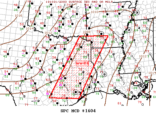 Mesoscale Discussion 1604
NWS Storm Prediction Center Norman OK
0614 PM CDT Wed Oct 31 2018
Areas affected...Southeast TX to Arklatex
Concerning...Tornado Watch 416...
Valid 312314Z - 010015Z
The severe weather threat for Tornado Watch 416 continues.
SUMMARY...Severe threat continues ahead of cold front across ww416.
DISCUSSION...Large-scale ascent is spreading across central TX ahead
of progressive short-wave trough. This appears to be aiding frontal
surge as squall line matures along the boundary, advancing southeast
at roughly 25kt. While a few supercells may be embedded along the
maturing squall line, small bow-type structures are more common due
to frontal forcing.
Ahead of the front, a semi-persistent cluster of convection has been
focused across the upper TX Coastal Plain where LLJ appears to be
aiding this activity. Multiple storm mergers are contributing to an
upward evolving cluster that should propagate toward the lower
Sabine River Valley later this evening. While earlier supercell
structures are less discrete, strengthening shear will continue to
support supercells and tornadoes, especially with pre-frontal
storms.
..Darrow.. 10/31/2018
...Please see http://www.spc.noaa.gov for graphic product...
ATTN...WFO...LZK...LCH...SHV...HGX...FWD...EWX...
LAT...LON 29239759 33919506 33909245 29249509 29239759
Re: OCTOBER 2018 - Stormy Halloween
Posted: Wed Oct 31, 2018 6:23 pm
by Belmer
EoA: 22z HRRR -
Black circles in image are areas where HRRR is starting to initialize discreet supercells develop ahead and along squall line upon frontal passage.
Re: OCTOBER 2018 - Stormy Halloween
Posted: Wed Oct 31, 2018 6:24 pm
by srainhoutx
Front has passed Brenham. Look for the front to arrive in NW Harris County within the hour and nearing Sugarland by 9 PM
Re: OCTOBER 2018 - Stormy Halloween
Posted: Wed Oct 31, 2018 6:32 pm
by unome
NWS Houston re-tweet - video from earlier, NW of Katy
https://twitter.com/baldbear87/status/1 ... 0200145920
Re: OCTOBER 2018 - Stormy Halloween
Posted: Wed Oct 31, 2018 6:46 pm
by srainhoutx
HGX cancels Tornado Watch for Brazos, Burleson, Houston, Madison Counties. Tornado Watch continues for other Counties in SE Texas
Re: OCTOBER 2018 - Stormy Halloween
Posted: Wed Oct 31, 2018 6:47 pm
by DoctorMu
unome wrote:still looks ugly to me
https://www.spc.noaa.gov/products/md/2018/md1604.html
Mesoscale Discussion 1604
NWS Storm Prediction Center Norman OK
0614 PM CDT Wed Oct 31 2018
Areas affected...Southeast TX to Arklatex
Concerning...Tornado Watch 416...
Valid 312314Z - 010015Z
The severe weather threat for Tornado Watch 416 continues.
SUMMARY...Severe threat continues ahead of cold front across ww416.
DISCUSSION...Large-scale ascent is spreading across central TX ahead
of progressive short-wave trough. This appears to be aiding frontal
surge as squall line matures along the boundary, advancing southeast
at roughly 25kt. While a few supercells may be embedded along the
maturing squall line, small bow-type structures are more common due
to frontal forcing.
Ahead of the front, a semi-persistent cluster of convection has been
focused across the upper TX Coastal Plain where LLJ appears to be
aiding this activity. Multiple storm mergers are contributing to an
upward evolving cluster that should propagate toward the lower
Sabine River Valley later this evening. While earlier supercell
structures are less discrete, strengthening shear will continue to
support supercells and tornadoes, especially with pre-frontal
storms.
..Darrow.. 10/31/2018
...Please see http://www.spc.noaa.gov for graphic product...
ATTN...WFO...LZK...LCH...SHV...HGX...FWD...EWX...
LAT...LON 29239759 33919506 33909245 29249509 29239759
Huge meso forming north of Beaumont.
Some of those mini-cells ahead of the squall line could spin up something weak.
Re: OCTOBER 2018 - Stormy Halloween
Posted: Wed Oct 31, 2018 6:54 pm
by srainhoutx
SPECIAL WEATHER STATEMENT
NATIONAL WEATHER SERVICE HOUSTON/GALVESTON TX
651 PM CDT WED OCT 31 2018
SAN JACINTO TX-WALKER TX-WASHINGTON TX-WALLER TX-GRIMES TX-
COLORADO TX-POLK TX-INLAND HARRIS TX-MONTGOMERY TX-HOUSTON TX-
AUSTIN TX-TRINITY TX-
651 PM CDT WED OCT 31 2018
...LINE OF STRONG THUNDERSTORMS MOVING THROUGH AREA...
AT 648 PM CDT, DOPPLER RADAR WAS TRACKING STRONG THUNDERSTORMS ALONG
A LINE EXTENDING FROM 6 MILES SOUTH OF FOREST TO NEAR HUNTSVILLE TO 8
MILES WEST OF HEMPSTEAD TO NEAR SCHULENBURG. MOVEMENT WAS EAST AT 25
MPH.
HALF INCH HAIL AND WINDS IN EXCESS OF 30 TO 40 MPH WILL BE POSSIBLE
WITH THESE STORMS. RAINFALL AMOUNTS OF 1 TO 2 INCHES IN AN HOUR WILL
BE POSSIBLE WITH THE STORMS.
LOCATIONS IMPACTED INCLUDE...
CONROE, HUNTSVILLE, TOMBALL, NAVASOTA, SEALY, HEMPSTEAD, WILLIS,
PRAIRIE VIEW, BELLVILLE, COLUMBUS, EAGLE LAKE, PINEHURST, APPLE
SPRINGS, THE WOODLANDS, HOCKLEY, TRINITY, WALLER, PANORAMA VILLAGE,
WEIMAR AND ONALASKA.
PRECAUTIONARY/PREPAREDNESS ACTIONS...
TORRENTIAL RAINFALL IS ALSO OCCURRING WITH THESE STORMS, AND MAY LEAD
TO LOCALIZED FLOODING. DO NOT DRIVE YOUR VEHICLE THROUGH FLOODED
ROADWAYS.
FREQUENT CLOUD TO GROUND LIGHTNING IS OCCURRING WITH THESE STORMS.
LIGHTNING CAN STRIKE 10 MILES AWAY FROM A THUNDERSTORM. SEEK A SAFE
SHELTER INSIDE A BUILDING OR VEHICLE.
THESE STORMS MAY INTENSIFY, SO BE CERTAIN TO MONITOR LOCAL RADIO
STATIONS AND AVAILABLE TELEVISION STATIONS FOR ADDITIONAL INFORMATION
AND POSSIBLE WARNINGS FROM THE NATIONAL WEATHER SERVICE.
Re: OCTOBER 2018 - Stormy Halloween
Posted: Wed Oct 31, 2018 7:43 pm
by BlueJay
Our storms have frightened many of our TRICK OR TREATERS tonight but we have had a few wet ghosts and goblins come by. So far everyone has been safe and happy. It's currently raining cats and dogs.
I'm wishing this weather board a Happy Halloween.
October 2018 is about done. Be safe.
Re: OCTOBER 2018 - Stormy Halloween
Posted: Wed Oct 31, 2018 7:47 pm
by jasons2k
The cell coming in near western part of The Woodlands needs to be watched for rotation.
Re: OCTOBER 2018 - Stormy Halloween
Posted: Wed Oct 31, 2018 8:10 pm
by don
The squall line is almost starting to look more like a mesoscale convective system than a typical linear squall line.
Re: OCTOBER 2018 - Stormy Halloween
Posted: Wed Oct 31, 2018 8:33 pm
by srainhoutx
8:30 PM Update from Jeff:
Slow moving band of heavy rainfall extends from The Woodlands to Katy and is moving toward the SE at 10-15mph.
Rainfall totals in the last 2-3 hours have averaged 2-3 inches over NW Harris, Waller, and SW Montgomery Counties. This is result in rises on area creeks in these areas. Little Cypress Creek at Becker Rd has risen to within 3 ft of bankfull and additional rainfall over the upper portions of Little Cypress Creek will likely result in this portion of the creek reaching bankfull this evening.
Due to the slow motion of this line, additional rainfall amounts of 1-2 inches on top of what has already fallen is possible. Think most of the larger creeks (Cypress, Spring, ect) will easily be able to handle this rainfall, bu upper Little Cypress Creek and later this evening lower South Mayde Creek (around Greenhouse) will likely rise toward or exceed bankfull. Impacts at both locations are fairly minor even just above bankfull.
Heavy rainfall will likely move back over areas already hard hit with 2-3 inches of rainfall late this afternoon from Missouri City to Westbury to TMC to Pasadena. Since that time, rainfall has ended allowing Willow Waterhole and Brays Bayou to crest and begin to fall, but this channels remain elevated. Additional heavy rainfall will likely result in new rises later this evening on these watersheds, but at this time no channel flooding is expected along these two watersheds.
Heavy rainfall rates will likely lead to street flooding as already experienced this afternoon on the south side of Harris County especially in areas of poor drainage and areas of construction.
Re: OCTOBER 2018 - Stormy Halloween
Posted: Wed Oct 31, 2018 8:42 pm
by Cpv17
We just lost power here right outside of Wharton.
Re: OCTOBER 2018 - Stormy Halloween
Posted: Wed Oct 31, 2018 8:51 pm
by don
BULLETIN - EAS ACTIVATION REQUESTED
Tornado Warning
National Weather Service Houston/Galveston TX
843 PM CDT WED OCT 31 2018
The National Weather Service in League City has issued a
* Tornado Warning for...
Central Harris County in southeastern Texas...
* Until 900 PM CDT.
* At 843 PM CDT, a severe thunderstorm capable of producing a tornado
was located over Langwood, or near Spring Valley, moving northeast
at 35 mph.
HAZARD...Tornado.
SOURCE...Radar indicated rotation.
IMPACT...Flying debris will be dangerous to those caught without
shelter. Mobile homes will be damaged or destroyed.
Damage to roofs, windows, and vehicles will occur. Tree
damage is likely.
* This dangerous storm will be near...
Northwestern Northside / Northline and Hidden Valley around 855 PM
CDT.
Aldine, Greater Greenspoint and southwestern Bush Intercontinental
Airport around 900 PM CDT.
PRECAUTIONARY/PREPAREDNESS ACTIONS...
TAKE COVER NOW! Move to a basement or an interior room on the lowest
floor of a sturdy building. Avoid windows. If you are outdoors, in a
mobile home, or in a vehicle, move to the closest substantial shelter
and protect yourself from flying debris.
Tornadoes are extremely difficult to see and confirm at night. Do not
wait to see or hear the tornado. TAKE COVER NOW!
Re: OCTOBER 2018 - Stormy Halloween
Posted: Wed Oct 31, 2018 9:33 pm
by Cromagnum
Finally got to Houston. 9 hours after our original time. Now stuck in baggage claim because they aren't unloading anything until the weather settles down. Travel day from hell.
Re: OCTOBER 2018 - Stormy Halloween
Posted: Wed Oct 31, 2018 9:48 pm
by jasons2k
Cromagnum wrote:Finally got to Houston. 9 hours after our original time. Now stuck in baggage claim because they aren't unloading anything until the weather settles down. Travel day from hell.
Glad you made it to Houston safely. Be safe getting home - it's stormy. You will sleep like a baby in your own bed tonight

Re: OCTOBER 2018 - Stormy Halloween
Posted: Wed Oct 31, 2018 11:56 pm
by Cpv17
Great rain we had here tonight! Picked up 2.1” without any severe weather.