

000
FXUS64 KHGX 041734
AFDHGX
Area Forecast Discussion
National Weather Service Houston/Galveston TX
1234 PM CDT Thu Oct 4 2018
.AVIATION...
Starting to see some iso/sct showers and tstms develop along the
seabreeze which should be making its way further inland this
afternoon. Outside of any convection, VFR conditions are expected
to persist into the overnight hours. Like the past couple nights,
lower cigs (IFR) and patchy fog should develop again...generally
north and west of the metro airports late tonight...burning off
toward mid morning Fri. 47
&&
.PREV DISCUSSION... /ISSUED 1103 AM CDT Thu Oct 4 2018/
Not a lot of changes with the forecast for the update. Things are
expected to pick up once again later this afternoon when we reach
convective temperatures. Activity could be scattered as given the
lack of a distinct boundary. Going grids look good. 41
&&
.PRELIMINARY POINT TEMPS/POPS...
College Station (CLL) 90 73 88 73 88 / 20 10 30 0 40
Houston (IAH) 89 75 87 74 87 / 40 10 40 10 50
Galveston (GLS) 85 79 84 78 84 / 30 20 40 20 50
&&
.HGX WATCHES/WARNINGS/ADVISORIES...
TX...NONE.
GM...NONE.
&&
$$
OCTOBER 2018 - Stormy Halloween
There doesn’t really appear to be any significant weather events across SETX anytime soon besides the possibility of a front mid next week. Most of the rain will be well north of us and east of us. I’m not sure why the rain chances are so high for the early part of next week. I don’t see anything that justifies having such high rain chances. Pretty boring weather pattern setting up over us if you ask me, but most of us would be happy with that after all the recent rains.


Oppressive dew points for about 1 more week, allegedly per models, until a real taste of fall. I look forward to winter, but would like to experience some fall weather first.
Last year we literally had a day of Fall between hot, humid weather and the epic December snowfall.
Last year we literally had a day of Fall between hot, humid weather and the epic December snowfall.
Sooooo....what's up with Michael (next named storm)?
-
srainhoutx

- Site Admin

- Posts: 19616
- Joined: Tue Feb 02, 2010 2:32 pm
- Location: Maggie Valley, NC
- Contact:
A Very broad monsoonal gyre across the Western Caribbean across Central America extending into the Eastern Pacific with multiple vortices rotating around the broad area of lower pressure in that Region. The models suggest a highly sheared lopsided low pressure with heavy rainfall extending well East of whatever surface low forms...if it does. We could see some sinking drier air around E/SE Texas as the disturbance moves NW to N and eventually NE into the SE Louisiana/MS/AL Western Florida Region. Fingers crossed that the Upper trough shifts over Texas and brings some cooler drier air and shields us from any worries.snowman65 wrote:Sooooo....what's up with Michael (next named storm)?
NWS NATIONAL HURRICANE CENTER MIAMI FL
800 AM EDT FRI OCT 5 2018
FOR THE NORTH ATLANTIC...CARIBBEAN SEA AND THE GULF OF MEXICO:
THE NATIONAL HURRICANE CENTER IS ISSUING ADVISORIES ON TROPICAL
STORM LESLIE, LOCATED OVER THE CENTRAL ATLANTIC OCEAN.
SHOWERS AND THUNDERSTORMS ASSOCIATED WITH AN AREA OF LOW PRESSURE
LOCATED NEAR CABO GRACIAS A DIOS ON THE EASTERN BORDER OF HONDURAS
AND NICARAGUA HAVE BECOME MORE CONCENTRATED DURING THE PAST SEVERAL
HOURS. ALTHOUGH STRONG WINDS ALOFT ARE LOCATED JUST TO THE NORTH OF
THIS SYSTEM, THE UPPER-LEVEL ENVIRONMENT IS EXPECTED TO BE CONDUCIVE
ENOUGH TO ALLOW SLOW DEVELOPMENT, AND A TROPICAL DEPRESSION COULD
FORM BY LATE THIS WEEKEND OR EARLY NEXT WEEK OVER THE NORTHWESTERN
CARIBBEAN SEA OR SOUTHERN GULF OF MEXICO WHILE THE SYSTEM MOVES
SLOWLY NORTHWESTWARD. REGARDLESS OF TROPICAL CYCLONE FORMATION,
THIS DISTURBANCE WILL CONTINUE TO BRING TORRENTIAL RAINS PRIMARILY
TO PORTIONS OF CENTRAL AMERICA AND THE YUCATAN PENINSULA DURING THE
NEXT FEW DAYS.
* FORMATION CHANCE THROUGH 48 HOURS...LOW...30 PERCENT.
* FORMATION CHANCE THROUGH 5 DAYS...MEDIUM...60 PERCENT.
$$
FORECASTER BEVEN
Carla/Alicia/Jerry(In The Eye)/Michelle/Charley/Ivan/Dennis/Katrina/Rita/Wilma/Humberto/Ike/Harvey
Member: National Weather Association
Facebook.com/Weather Infinity
Twitter @WeatherInfinity
Member: National Weather Association
Facebook.com/Weather Infinity
Twitter @WeatherInfinity
After the next 3-4 days things appear to be drying out over our area.


-
srainhoutx
- Site Admin
- Posts: 19616
- Joined: Tue Feb 02, 2010 2:32 pm
- Location: Maggie Valley, NC
- Contact:
Oh look. Cooler weather on the way too...
- Attachments
-
Carla/Alicia/Jerry(In The Eye)/Michelle/Charley/Ivan/Dennis/Katrina/Rita/Wilma/Humberto/Ike/Harvey
Member: National Weather Association
Facebook.com/Weather Infinity
Twitter @WeatherInfinity
Member: National Weather Association
Facebook.com/Weather Infinity
Twitter @WeatherInfinity
The initial front should if climo prevails put the breaks on Michael heading on a Texas vector.

The second front next weekend puts the hammer down.

The second front next weekend puts the hammer down.
Last edited by DoctorMu on Sat Oct 06, 2018 10:15 am, edited 1 time in total.
-
srainhoutx
- Site Admin
- Posts: 19616
- Joined: Tue Feb 02, 2010 2:32 pm
- Location: Maggie Valley, NC
- Contact:
Enjoy the last vestiges of SE Texas Summer this weekend as changes are brewing as we enter the second week of October. INVEST 91L is attempting to organize as a weak surface low has developed just North of Bay Islands of Honduras in the NW Caribbean Sea. Wind shear is rather strong and should keep any development in check as the tropical disturbance drift slowly NW and then N over the weekend. A Strong Fall Frontal Boundary is currently located across portions of the Panhandle. Amarillo is currently 47F and Freeze/Frost Warnings are flying across Western/Central Nebraska. A very potent shortwave currently over Western Oregon/Idaho is dropping SE in the NW flow aloft and will deepen a digging Great Basin/Intermountain West upper trough as the weekend progresses. Another very potent upper air disturbance is diving SE across British Columbia this morning and will dig a very deep full latitude trough across the Intermountain West and the Plains as the work week begins. At this time it appears that 91L will not impact SE Texas or SW Louisiana, but we will continue to monitor for any unexpected changes. 91L or future Michael may play a role in our sensible weather by allowing a first surge of modified Canadian Air to filter into our Region Wednesday into Thursday as the tropical system passes off to our ESE and E. A much stronger Fall Front is penciled in for arrival Friday into Saturday. As of this morning, it appears that our Area may get that first legitimate taste of Fall Weather next Sunday with morning lows in the upper 40's to low 50's across SE Texas.
- Attachments
-
Carla/Alicia/Jerry(In The Eye)/Michelle/Charley/Ivan/Dennis/Katrina/Rita/Wilma/Humberto/Ike/Harvey
Member: National Weather Association
Facebook.com/Weather Infinity
Twitter @WeatherInfinity
Member: National Weather Association
Facebook.com/Weather Infinity
Twitter @WeatherInfinity
-
Katdaddy

- Global Moderator

- Posts: 2502
- Joined: Thu Feb 04, 2010 8:18 am
- Location: League City, Tx
- Contact:
Who is ready for the first real strong TX cold front? As much as I dislike cold weather.............unless it snows  .......the first strong cold front is always refreshing and finishes off any late season NW GOM tropical threats for the season. For now, one more hot and humid weekend with a few scattered showers and thunderstorms during the afternoon.
I don’t really know what to think of it, but kind of out of nowhere the 12z GFS has a lot of rain for western parts of the viewing area next weekend.
Hmmm...I'm salivating for a potential week of NW flow and a crisp weekend. It may be just the front. Don't mess this up!Cpv17 wrote:I don’t really know what to think of it, but kind of out of nowhere the 12z GFS has a lot of rain for western parts of the viewing area next weekend.
I see it now - the fly in the ointment is moisture from a Pacific hurricane that lands ashore in Mexico. haha It will probably evaporate in the next GFS run! Having said that I noticed the Euro brings the storm ashore on the same spot in the Baja Peninsula.

-
srainhoutx
- Site Admin
- Posts: 19616
- Joined: Tue Feb 02, 2010 2:32 pm
- Location: Maggie Valley, NC
- Contact:
EPAC Hurricane Sergio and its remnants likely will be a wildcard regarding our sensible weather next weekend as it merges with that Fall Cold Front. Over running clouds and possibly mid/upper level moisture and strong fronts can lead to rainfall after the front passes giving us cool and gloomy weather we often see in Fall and in Winter.
Carla/Alicia/Jerry(In The Eye)/Michelle/Charley/Ivan/Dennis/Katrina/Rita/Wilma/Humberto/Ike/Harvey
Member: National Weather Association
Facebook.com/Weather Infinity
Twitter @WeatherInfinity
Member: National Weather Association
Facebook.com/Weather Infinity
Twitter @WeatherInfinity
Yeah, a dreary mid level moisture weekend on tap in a week. A real shame, because Friday's front would have been pretty bone dry otherwise.srainhoutx wrote:EPAC Hurricane Sergio and its remnants likely will be a wildcard regarding our sensible weather next weekend as it merges with that Fall Cold Front. Over running clouds and possibly mid/upper level moisture and strong fronts can lead to rainfall after the front passes giving us cool and gloomy weather we often see in Fall and in Winter.
Sergio is currently a major EPAC fish storm poised to take a turn NE and weaken. It certainly would be in position to ruin next weekend's BBQs and other outdoor activities.
https://www.nhc.noaa.gov/graphics_ep1.s ... e#contents
Go away.
Last edited by DoctorMu on Sat Oct 06, 2018 5:16 pm, edited 1 time in total.
Sometimes these EPAC storms can cause copious amounts of rainfall in Texas when they go into Mexico like that so it’s just something to keep an eye on.DoctorMu wrote:Yeah, a dreary mid level moisture weekend on tap in a week. A real shame, because Friday's front would have been pretty bone dry otherwise.srainhoutx wrote:EPAC Hurricane Sergio and its remnants likely will be a wildcard regarding our sensible weather next weekend as it merges with that Fall Cold Front. Over running clouds and possibly mid/upper level moisture and strong fronts can lead to rainfall after the front passes giving us cool and gloomy weather we often see in Fall and in Winter.
Sergio is currently a major EPAC fish storm poised to take a turn NE and weaken. It certainly would be posed to ruin next weekend's BBQs and other outdoor activities.
https://www.nhc.noaa.gov/graphics_ep1.s ... e#contents
Go away.
-
srainhoutx
- Site Admin
- Posts: 19616
- Joined: Tue Feb 02, 2010 2:32 pm
- Location: Maggie Valley, NC
- Contact:
Advisories from the NHC have been issued for Potential Tropical Cyclone #14 in the NW Caribbean Sea.
POTENTIAL TROPICAL CYCLONE FOURTEEN DISCUSSION NUMBER 1
NWS NATIONAL HURRICANE CENTER MIAMI FL AL142018
400 PM CDT SAT OCT 06 2018
SATELLITE IMAGERY AND SURFACE OBSERVATIONS INDICATE THAT THE
CIRCULATION OF THE LOW PRESSURE AREA IN THE NORTHWESTERN CARIBBEAN
SEA IS GETTING BETTER DEFINED, AND THAT THE ASSOCIATED CONVECTION
IS BECOMING BETTER ORGANIZED. WHILE THE SYSTEM IS CURRENTLY NOT
WELL ENOUGH ORGANIZED TO CALL IT A TROPICAL DEPRESSION, CURRENT
INDICATIONS IN THE GLOBAL MODELS AND THE INTENSITY GUIDANCE ARE THAT
THE SYSTEM WILL DEVELOP INTO A TROPICAL CYCLONE WITHIN 24 H AND
COULD BRING TROPICAL STORM CONDITIONS TO PORTIONS OF WESTERN CUBA
AND THE NORTHEASTERN YUCATAN PENINSULA. BASED ON THE NEED FOR
WARNINGS AND WATCHES IN THESE AREAS, ADVISORIES ARE BEING INITIATED
ON POTENTIAL TROPICAL CYCLONE FOURTEEN.
ALTHOUGH THE INTENSITY GUIDANCE IS IN EXCELLENT AGREEMENT THAT THE
SYSTEM SHOULD STRENGTHEN THROUGH THE FORECAST PERIOD, THE GLOBAL
MODELS INDICATE THAT SHEAR CAUSED BY AN UPPER-LEVEL TROUGH OVER THE
GULF OF MEXICO WILL PERSIST THROUGH AT LEAST 48 H. IN ADDITION, THE
STRONGEST WINDS ARE CURRENTLY WELL REMOVED FROM THE CENTER, WHICH IS
LIKELY TO SLOW DEVELOPMENT. BASED ON THIS, THE INTENSITY FORECAST
IS IN THE LOWER PART OF THE GUIDANCE ENVELOPE THROUGH 48 H, AND THEN
SHOWS A FASTER RATE OF DEVELOPMENT FROM 48-96 H WHEN THE SHEAR IS
FORECAST TO DIMINISH. THE INTENSITY FORECAST IS CLOSEST TO A BLEND
OF THE IVCN AND HCCA CONSENSUS MODELS.
FOR THE FIRST 24-48 H, THE DISTURBANCE SHOULD MOVE GENERALLY
NORTHWARD ON THE WESTERN SIDE OF A WEAK MID-LEVEL RIDGE OVER THE
CARIBBEAN SEA. AFTER THAT TIME, A LARGE MID-LATITUDE TROUGH OVER
THE CENTRAL UNITED STATES AND A MID- TO UPPER-LEVEL RIDGE OVER THE
WESTERN ATLANTIC SHOULD STEER THE SYSTEM GENERALLY NORTHWARD AT A
FASTER FORWARD SPEED, WITH THE SYSTEM EXPECTED TO MOVE NEAR OR OVER
THE NORTHERN GULF COAST IN ABOUT 96 H. AFTER LANDFALL, THE SYSTEM
IS LIKELY TO RECURVE NORTHEASTWARD INTO THE WESTERLIES. THE TRACK
GUIDANCE IS IN GOOD OVERALL AGREEMENT WITH THIS SCENARIO. HOWEVER,
IT SHOULD BE NOTED THAT THERE IS A NEARLY 300 N MI CROSS-TRACK
SPREAD IN THE GUIDANCE AT THE 96-H POINT. THE FORECAST TRACK LIES
JUST TO THE WEST OF THE VARIOUS CONSENSUS MODELS.
KEY MESSAGES FOR POTENTIAL TROPICAL CYCLONE FOURTEEN:
1. THIS SYSTEM IS EXPECTED TO PRODUCE HEAVY RAINFALL AND FLASH
FLOODING OVER PORTIONS OF CENTRAL AMERICA, WESTERN CUBA, AND THE
NORTHEASTERN YUCATAN PENINSULA OF MEXICO DURING THE NEXT COUPLE OF
DAYS. THE SYSTEM IS ALSO FORECAST TO BECOME A TROPICAL STORM BY
SUNDAY NIGHT AND TROPICAL STORM CONDITIONS ARE EXPECTED OVER
PORTIONS OF WESTERN CUBA WHERE A TROPICAL STORM WARNING IS IN
EFFECT.
2. THE SYSTEM COULD BRING STORM SURGE, RAINFALL, AND WIND IMPACTS TO
PORTIONS OF THE NORTHERN GULF COAST BY MID-WEEK, ALTHOUGH IT IS TOO
SOON TO SPECIFY THE EXACT LOCATION AND MAGNITUDE OF THESE IMPACTS.
RESIDENTS IN THESE AREAS SHOULD MONITOR THE PROGRESS OF THIS SYSTEM.
FORECAST POSITIONS AND MAX WINDS
INIT 06/2100Z 18.0N 86.6W 25 KT 30 MPH...POTENTIAL TROP CYCLONE
12H 07/0600Z 18.7N 86.7W 25 KT 30 MPH
24H 07/1800Z 19.9N 86.6W 30 KT 35 MPH...TROPICAL CYCLONE
36H 08/0600Z 21.0N 86.6W 35 KT 40 MPH
48H 08/1800Z 22.5N 86.7W 40 KT 45 MPH
72H 09/1800Z 26.0N 87.5W 55 KT 65 MPH
96H 10/1800Z 30.5N 86.5W 60 KT 70 MPH
120H 11/1800Z 35.5N 81.5W 30 KT 35 MPH...INLAND
$$
FORECASTER BEVEN
Carla/Alicia/Jerry(In The Eye)/Michelle/Charley/Ivan/Dennis/Katrina/Rita/Wilma/Humberto/Ike/Harvey
Member: National Weather Association
Facebook.com/Weather Infinity
Twitter @WeatherInfinity
Member: National Weather Association
Facebook.com/Weather Infinity
Twitter @WeatherInfinity
Cpv17 wrote:Sometimes these EPAC storms can cause copious amounts of rainfall in Texas when they go into Mexico like that so it’s just something to keep an eye on.DoctorMu wrote:Yeah, a dreary mid level moisture weekend on tap in a week. A real shame, because Friday's front would have been pretty bone dry otherwise.srainhoutx wrote:EPAC Hurricane Sergio and its remnants likely will be a wildcard regarding our sensible weather next weekend as it merges with that Fall Cold Front. Over running clouds and possibly mid/upper level moisture and strong fronts can lead to rainfall after the front passes giving us cool and gloomy weather we often see in Fall and in Winter.
Sergio is currently a major EPAC fish storm poised to take a turn NE and weaken. It certainly would be posed to ruin next weekend's BBQs and other outdoor activities.
https://www.nhc.noaa.gov/graphics_ep1.s ... e#contents
Go away.
Absolutely. Especially this time of year. If that moisture is caught up in a front or the SJT, there is significant potential for entraining.
-
srainhoutx
- Site Admin
- Posts: 19616
- Joined: Tue Feb 02, 2010 2:32 pm
- Location: Maggie Valley, NC
- Contact:
Tropical Storm Michael Tropical Cyclone Update NWS National Hurricane Center Miami FL AL142018 1155 AM CDT Sun Oct 07 2018 ...DEPRESSION STRENGTHENS TO A TROPICAL STORM... Satellite wind data indicate that the depression has strengthened into Tropical Storm Michael. The maximum winds are estimated to be 40 mph (65 km/h) with higher gusts. An Air Force Reserve Hurricane Hunter aircraft is currently en route to investigate Michael. SUMMARY OF 1155 AM CDT...1655 UTC...INFORMATION ----------------------------------------------- LOCATION...19.2N 86.9W ABOUT 90 MI...145 KM S OF COZUMEL MEXICO ABOUT 225 MI...365 KM SW OF THE WESTERN TIP OF CUBA MAXIMUM SUSTAINED WINDS...40 MPH...65 KM/H PRESENT MOVEMENT...N OR 360 DEGREES AT 5 MPH...7 KM/H MINIMUM CENTRAL PRESSURE...1004 MB...29.65 INCHES $$ Forecaster Brown
Carla/Alicia/Jerry(In The Eye)/Michelle/Charley/Ivan/Dennis/Katrina/Rita/Wilma/Humberto/Ike/Harvey
Member: National Weather Association
Facebook.com/Weather Infinity
Twitter @WeatherInfinity
Member: National Weather Association
Facebook.com/Weather Infinity
Twitter @WeatherInfinity
Bring on the freezing cold weather. I've had enough of this miserable summer already. I dont want to thaw out until next May.


EURO
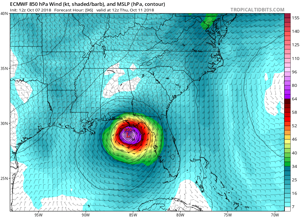
UKMET

GFS

EURO and UKMET have Michael as a hurricane with 950 millibars.
UKMET
GFS
EURO and UKMET have Michael as a hurricane with 950 millibars.