
MAY 2018 - Feelin Hot Hot Hot to end May
-
srainhoutx

- Site Admin

- Posts: 19616
- Joined: Tue Feb 02, 2010 2:32 pm
- Location: Maggie Valley, NC
- Contact:
A Severe Thunderstorm Watch has been issued across portions of N Central/Central Texas until 2:00 PM CDT
- Attachments
-
Carla/Alicia/Jerry(In The Eye)/Michelle/Charley/Ivan/Dennis/Katrina/Rita/Wilma/Humberto/Ike/Harvey
Member: National Weather Association
Facebook.com/Weather Infinity
Twitter @WeatherInfinity
Member: National Weather Association
Facebook.com/Weather Infinity
Twitter @WeatherInfinity

That's just rubbing it in now!srainhoutx wrote:A Severe Thunderstorm Watch has been issued across portions of N Central/Central Texas until 2:00 PM CDT
Still only 50% pops for us. I have a feeling we will spend the next couple of days looking up to the north and west with envy.
I'm not envious of the severe weather, would like our roof to last another 5 yrs
TWC was saying 70 mph winds were possible in Dallas area - already some power lines down
https://twitter.com/iembot_fwd
http://www.wpc.ncep.noaa.gov/exper/lsr/ ... autoreload
http://stormcenter.oncor.com/external/default.html
https://poweroutage.us/area/state/texas
http://weather.cod.edu/satrad/exper/?pa ... colorbars=

Mesoscale Discussion 0336
NWS Storm Prediction Center Norman OK
1235 PM CDT Thu May 03 2018
Areas affected...Portions of north/central/east TX...southeastern OK...western AR...and far southern MO
Concerning...Severe Thunderstorm Watch 70...
Valid 031735Z - 031900Z
The severe weather threat for Severe Thunderstorm Watch 70 continues.
SUMMARY...The overall severe threat across WW 70 appears to be decreasing. The need for a downstream watch remains unclear, but does not appear likely in the short term.
DISCUSSION...Recent radar trends across central/north TX have shown a general decrease in convective intensity with a loosely organized line of thunderstorms. Better large-scale forcing for ascent associated with an upper trough/low over the central High Plains will remain displaced to the north of the lower MS Valley/Ozarks regions today. The orientation of the squall line is also becoming increasingly parallel to the mean mid-level southwesterly flow, with a corresponding decrease in forward speed noted over the past several hours. Still, modest diurnal heating beneath a
mid/upper-level cloud deck ahead of the ongoing line and plentiful low-level moisture should result in a gradual increase in instability this afternoon. A veering/strengthening wind profile with resultant effective bulk shear values around 40-50 kt would also support support some updraft organization. Regardless, the overall severe threat appears relatively marginal given limited low-level convergence and weak instability. The prospect for a downstream watch appears unlikely in the short term, although convective trends will be monitored through the afternoon.
..Gleason.. 05/03/2018
...Please see http://www.spc.noaa.gov for graphic product...
ATTN...WFO...LZK...SGF...SHV...TSA...FWD...
and updated day 2
SPC AC 031727
Day 2 Convective Outlook
NWS Storm Prediction Center Norman OK
1227 PM CDT Thu May 03 2018
Valid 041200Z - 051200Z
...THERE IS A MARGINAL RISK OF SEVERE THUNDERSTORMS FOR PORTIONS OF THE NORTHEAST AND UPPER OHIO VALLEY AND PARTS OF THE TEXAS COASTAL PLAIN...
...SUMMARY...
Isolated severe storms, with a primary threat of damaging winds, will be possible from New England to the Ohio Valley Friday. A few severe storms, capable of damaging winds and isolated severe hail, will also be possible over parts of Texas.
...Upper OH Valley into the Northeast...
A positive-tilt larger scale mid-level trough will push east into the region as the primary vorticity maximum moves from the central Great Lakes to the mouth of the St. Lawrence River. Likewise, a surface low will develop northeast from central Lower MI during the morning to near the NY/Quebec/Ontario border by early evening. A plume of lower 60s dewpoints and some diurnal heating will result in weak instability by early afternoon ahead of a cold front located from Lake Erie southwestward into the lower OH Valley. The front will sweep eastward during the afternoon and promote low-topped thunderstorms developing near the front over the OH Valley and lower Great Lakes. Forecast soundings show strong westerly low- to mid-level flow which will support a risk for wind damage with the stronger downdrafts. Farther east, a couple of isolated to scattered clusters of thunderstorms will probably develop during the afternoon as height falls overspread the area. A localized wind/small hail risk may develop with this activity as well. Storm intensity will likely diminish during the evening as instability wanes.
...Coastal Plain of TX into the lower Rio Grande Valley...
The belt of strong mid-level flow will likely lag behind a composite outflow/front. Lift associated with this boundary will likely foster shower/thunderstorm development through the day along and behind the front. A couple of stronger storms may develop during the afternoon when boundary-layer heating/instability is maximized. Fairly subdued but veering flow in the lowest 6km beneath 50-kt upper-level flow will potentially support storm organization. Localized hail/wind will likely be the primary threats with the stronger storms.
...MAXIMUM RISK BY HAZARD...
Tornado: 2% - Marginal
Wind: 5% - Marginal
Hail: 5% - Marginal
..Smith.. 05/03/2018

Today's a bust with the dry line.
Tomorrow - there's a pretty good chance with the incoming shortwave and front, especially in the NW counties.
PW near 2 inches.
HOU and Galveston may have the best opportunity for rain early Saturday.
Tomorrow - there's a pretty good chance with the incoming shortwave and front, especially in the NW counties.
PW near 2 inches.
HOU and Galveston may have the best opportunity for rain early Saturday.
Yeah, 60% POPs now for Friday night. Looks like we should get some rain from his. As long as the lawn gets watered, I will be happy. Tough call if our swim meet Saturday gets cancelled or not..
-
Katdaddy

- Global Moderator

- Posts: 2502
- Joined: Thu Feb 04, 2010 8:18 am
- Location: League City, Tx
- Contact:
Showers and thunderstorms will be possible later this afternoon and tonight as a cool front moves into SE TX. The SPC has a marginal risk area for severe thunderstorms across S and SE TX with main threat being damaging winds along with some localized heavy rain. Skies will begin clearing Saturday afternoon leading to several nice but hot days next week as high temps approach 90F.
- Attachments
-
- Screen Shot 2018-05-04 at 5.18.43 AM.png (13.53 KiB) Viewed 3763 times
POPs lowered to 50% now. No bueno.
Here is an update from Jeff:
Storm system will approach and cross SE TX today into Saturday.
Heavy rainfall will be possible this afternoon NW of a line from Huntsville to Columbus and possibly tonight along and north of I-10.
Radar this morning shows a developing large mass of thunderstorms across SW/C TX. This line has been increasing in intensity and coverage this morning as a short wave ejects out of MX and interacts with a frontal boundary moving SE over NW TX. Morning soundings from CRP and BRO shows a good fetch of low level inflow over the coastal bend which will help to feed this activity through the morning hours as it approaches SE TX.
While there will be a lot of activity to our west this morning the main question is how far SE this activity survives today. Both meso and global models indicate and general weakening trend with the activity as it moves into SE TX and encounters stronger ridging aloft over the Gulf of Mexico. Think this first line will weaken from Columbus to College Station later this morning with a slowing outflow boundary likely reaching a Wharton to Hempstead to Conroe to Huntsville line by afternoon. Additional activity may fire off this outflow boundary, but short range guidance does not show much. Later this evening the surface front will sink into the region and short range guidance shows additional showers and thunderstorms developing this evening into Saturday morning.
With PWS of nearly 2.0 inches over the area and slowing storm motions, heavy rainfall will be possible this afternoon into early Saturday. Greatest risk at this time will be along and NW of a line from Columbus to Huntsville where 1-3 inches will be possible. Some guidance has been hinting at much higher totals of up to 5-6 inches in that region. This would only appear possible if the morning activity currently nearing I-35 does not weaken and slows over the area this afternoon. One other item to watch during this event is the potential for any sustained heavy rain axis to sink deeper into SE TX especially this evening as low level inflow increases off the Gulf. This is not supported in current model guidance, but it has happened in the past.
Overall ground conditions are dry and should be able to handle 2-4 inches of rainfall without any significant flooding concerns. Most areas will likely see 1-2 inches N of I-10 with 2-3 inches NW of Columbus to Huntsville…isolated totals could be higher. South of I-10 rainfall amounts will likely average less than 1 inch.
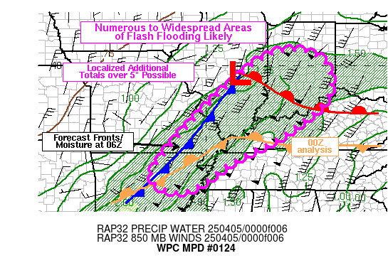
WPC Day 1 Excessive Rainfall Outlook:
Storm system will approach and cross SE TX today into Saturday.
Heavy rainfall will be possible this afternoon NW of a line from Huntsville to Columbus and possibly tonight along and north of I-10.
Radar this morning shows a developing large mass of thunderstorms across SW/C TX. This line has been increasing in intensity and coverage this morning as a short wave ejects out of MX and interacts with a frontal boundary moving SE over NW TX. Morning soundings from CRP and BRO shows a good fetch of low level inflow over the coastal bend which will help to feed this activity through the morning hours as it approaches SE TX.
While there will be a lot of activity to our west this morning the main question is how far SE this activity survives today. Both meso and global models indicate and general weakening trend with the activity as it moves into SE TX and encounters stronger ridging aloft over the Gulf of Mexico. Think this first line will weaken from Columbus to College Station later this morning with a slowing outflow boundary likely reaching a Wharton to Hempstead to Conroe to Huntsville line by afternoon. Additional activity may fire off this outflow boundary, but short range guidance does not show much. Later this evening the surface front will sink into the region and short range guidance shows additional showers and thunderstorms developing this evening into Saturday morning.
With PWS of nearly 2.0 inches over the area and slowing storm motions, heavy rainfall will be possible this afternoon into early Saturday. Greatest risk at this time will be along and NW of a line from Columbus to Huntsville where 1-3 inches will be possible. Some guidance has been hinting at much higher totals of up to 5-6 inches in that region. This would only appear possible if the morning activity currently nearing I-35 does not weaken and slows over the area this afternoon. One other item to watch during this event is the potential for any sustained heavy rain axis to sink deeper into SE TX especially this evening as low level inflow increases off the Gulf. This is not supported in current model guidance, but it has happened in the past.
Overall ground conditions are dry and should be able to handle 2-4 inches of rainfall without any significant flooding concerns. Most areas will likely see 1-2 inches N of I-10 with 2-3 inches NW of Columbus to Huntsville…isolated totals could be higher. South of I-10 rainfall amounts will likely average less than 1 inch.
WPC Day 1 Excessive Rainfall Outlook:
- Add Image

The big question is does it hold together or fall apart? Models versus instinct. Ridge versus diffluence. Tough call.
We've got Streamer showers, but the line appears to be hitting the wall around a Caldwell to Hearne line (i.e., the AggieDome). I'd be shocked if we get more than an inch of rain. It will be slow and steady all day though. A little soaking.jasons wrote:The big question is does it hold together or fall apart? Models versus instinct. Ridge versus diffluence. Tough call.
Looks iffy for you Jason. NAM is more optimistic than GFS.


Looks like some new cells are popping-up inside the mass of rain. A lot N and NE of the Bryan/College Station areas and also towards Giddings and Fayeteville. A sign that the diffluence and instability is winning out...
For what its worth the HRRR is starting to show some redevelopment in our neck of the woods around 2-3 AM
Dare I say it, but I think we're about to get some rain 
Edit to add - as I look at it, just not overly impressed. The outlflow is advancing east without much development on it. We would need a LLJ to setup and feed this overnight. Maybe tonight will be a different story but for now it's pretty vanilla.
Edit to add - as I look at it, just not overly impressed. The outlflow is advancing east without much development on it. We would need a LLJ to setup and feed this overnight. Maybe tonight will be a different story but for now it's pretty vanilla.
Looks like we're going to get a dash of rain, but goodness has that line of storms really become anemic.