
I like the new "Inundation Map" feature https://www.harriscountyfws.org/ If you zoom in on the gauge at Little Cypress at Becker (out of banks) it shows the expected area flooding
Possible round 2 today? Bumped up rain chances to 50%
MAY 2018 - Feelin Hot Hot Hot to end May
Area Forecast Discussion
National Weather Service Houston/Galveston TX
349 AM CDT Mon May 21 2018
.DISCUSSION...
At 300 AM, radar was rather quiet with just a few showers near Matagorda bay. Short term guidance is bullish with redevelopment over much of the CWA between 09-12z. Yesterday, the Hi_Res ARW outperformed every other model but it seems overdone today as the air mass should be worked over. 06z surface analysis shows several boundaries lying across SE TX and these features will likely serve as a focus for additional shra/tsra today. Fcst soundings show convective temperatures in the mid 80's so would expect development beginning later this morning and continuing into the afternoon. NAM soundings much more unstable than the GFS with PW values approaching 2.00 inches by 21z while the GFS is only 1.60. 850m mb temps are cooler so trimmed a few degrees from previous forecast Max T. Will broad brush 50 PoPs today with lower rain chances near the coast this afternoon. Rain should end early this evening with the loss of heating. Could get some patchy fog by early Tuesday morning as skies slowly clear.
An upper level ridge over northern Mexico will expand into Texas through the mid week with a gradual increase in temperatures. PW values remain below 1.50 inches and convective temperatures are in the upper 80's. Subsidence from the expanding ridge should limit convective potential but fcst soundings show weak capping that could be overcome with heating. Can't rule out isolated showers so will carry 20 PoPs through the period.
The end of the week is looking more interesting. Both the Canadian and the ECMWF try develop low pressure over the southern Gulf, both models vary in their respective placements, with the ECMWF farther west. The GFS keeps an open wave and moves this feature toward the FL peninsula. The Memorial Day weekend forecast will be tied to how this system eventually evolves. FWIW, WPC currently has a weak low over south central Louisiana and for now will lean in that direction. Will keep rain chances in the forecast through the holiday weekend, especially over the eastern half of the CWA. Confidence is low and the forecast will likely change several times by the time next weekend rolls around. It'd be a good idea to keep up with the forecasts for next weekend. 43
&&
.CLIMATE...
Houston Hobby did not receive measurable rain yesterday so that is 29 consecutive days without measurable rain. This is the 12th longest streak of consecutive days without rain for this location. Bush IAH only reached 87 yesterday and this ends the 90 day streak at 8 days. 43
&&
.MARINE...
Caution flags are currently flying for Matagorda Bay and western nearshore waters as winds remain elevated this morning. These winds should slacken off later this morning. Light onshore flow continues through around midweek before becoming light and variable. Periods of showers and thunderstorms are expected on and off through the period. 11
&&
.PRELIMINARY POINT TEMPS/POPS...
College Station (CLL) 89 69 91 70 92 / 50 20 20 10 10
Houston (IAH) 88 71 91 73 92 / 50 20 20 10 20
Galveston (GLS) 84 76 84 78 84 / 50 10 20 10 10
&&
.HGX WATCHES/WARNINGS/ADVISORIES...
TX...NONE.
GM...SMALL CRAFT SHOULD EXERCISE CAUTION until 9 AM CDT this morning
for the following zones: Coastal waters from Freeport to Matagorda Ship Channel TX out 20 NM... Matagorda Bay.
Hazardous Weather Outlook
National Weather Service Houston/Galveston TX
355 AM CDT Mon May 21 2018
...
This hazardous weather outlook is for portions of Southeast Texas..
.DAY ONE... Today and Tonight
Scattered showers and thunderstorms are expected to become more numerous during the late morning and early afternoon. Brief, but locally heavy rain will be possible with a few of the stronger storms. The storms are expected to end during the early evening.
.DAYS TWO THROUGH SEVEN... Tuesday through Sunday
The warmer than normal afternoon temperatures are expected continue through the upcoming week. Heat index values could reach 100 degrees by the end of the week. Because of how early in the year this heat is occurring, residents are urged to take precautions for heat illness. These include taking frequent breaks if working outdoors, wearing lightweight and loose-fitting clothing and drinking plenty of water.
.SPOTTER INFORMATION STATEMENT...
Spotter activation will not be needed.
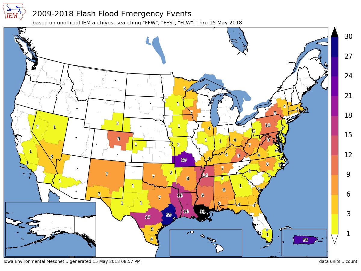
interesting map from Daryl Herzmann at https://mesonet.agron.iastate.edu/
2009-2018 Flash Flood Emergency Events (thru May 15)
https://twitter.com/akrherz/status/996570655146627073
...here's what my archives have for number of Flash Flood Emergency events by NWS Office. Unofficial totals of course, please let me know of issues.
https://pbs.twimg.com/media/DdSHk_tV0AANovj.jpg:large
-
srainhoutx

- Site Admin

- Posts: 19616
- Joined: Tue Feb 02, 2010 2:32 pm
- Location: Maggie Valley, NC
- Contact:
A quick look ahead toward the Long Memorial Day Weekend and what our weather may bring. Let me echo what HGX stated this morning regarding a very low confidence in the forecast beyond Thursday/Friday with the potential of a weak surface low and sharp upper trough developing across the Central Gulf of Mexico. At this time we do NOT believe that anything tropical will form at this time, but a very large area of disturbed weather is situated in the Western Caribbean Sea this morning associated with a broad area of monsoonal gyre lower pressures extending from the Eastern Pacific across Central America into the Western Caribbean Sea.

The ensembles suggest that height falls aloft and lowering pressures at the surface begin to enter the Southern Gulf on Thursday and a weak surface low develops on Friday. Abundant deep tropical moisture will attend this feature and heavy flooding rainfall maybe possible during the long Holiday weekend roughly from East Texas to Florida along the West Central Gulf Coast and inland ahead of a slow moving frontal boundary. We expect many changes throughout the coning week as the guidance attempts to resolve this developing storm system and the potential heavy rainfall threat mainly along the Louisiana Gulf Coast and points E. Stay Tuned!
The ensembles suggest that height falls aloft and lowering pressures at the surface begin to enter the Southern Gulf on Thursday and a weak surface low develops on Friday. Abundant deep tropical moisture will attend this feature and heavy flooding rainfall maybe possible during the long Holiday weekend roughly from East Texas to Florida along the West Central Gulf Coast and inland ahead of a slow moving frontal boundary. We expect many changes throughout the coning week as the guidance attempts to resolve this developing storm system and the potential heavy rainfall threat mainly along the Louisiana Gulf Coast and points E. Stay Tuned!
Carla/Alicia/Jerry(In The Eye)/Michelle/Charley/Ivan/Dennis/Katrina/Rita/Wilma/Humberto/Ike/Harvey
Member: National Weather Association
Facebook.com/Weather Infinity
Twitter @WeatherInfinity
Member: National Weather Association
Facebook.com/Weather Infinity
Twitter @WeatherInfinity
-
srainhoutx
- Site Admin
- Posts: 19616
- Joined: Tue Feb 02, 2010 2:32 pm
- Location: Maggie Valley, NC
- Contact:
NWS National Hurricane Center Miami FL
830 AM EDT Mon May 21 2018
For the North Atlantic...Caribbean Sea and the Gulf of Mexico:
1. Widespread cloudiness and showers extending from the northwestern
Caribbean Sea across Cuba and the Florida peninsula are associated
with the interaction of a large upper-level low with a weak surface
trough. While environmental conditions are expected to be
unfavorable for development during the next couple of days, some
gradual development is possible later this week while the system
moves into the central or eastern Gulf of Mexico. Regardless of
development, locally heavy rainfall is possible across western Cuba
and Florida over the next several days. For more information on
the heavy rain threat, please see products issued by your local
weather office. The next Special Tropical Weather Outlook on this
system will be issued by 800 PM EDT tonight.
* Formation chance through 48 hours...low...near 0 percent.
* Formation chance through 5 days...low...20 percent.
Forecaster Blake
Carla/Alicia/Jerry(In The Eye)/Michelle/Charley/Ivan/Dennis/Katrina/Rita/Wilma/Humberto/Ike/Harvey
Member: National Weather Association
Facebook.com/Weather Infinity
Twitter @WeatherInfinity
Member: National Weather Association
Facebook.com/Weather Infinity
Twitter @WeatherInfinity
-
srainhoutx
- Site Admin
- Posts: 19616
- Joined: Tue Feb 02, 2010 2:32 pm
- Location: Maggie Valley, NC
- Contact:
Monday morning briefing from Jeff:
Additional showers and thunderstorms likely today over the region.
Low level moisture is making a return to the region this morning after being pushed southward yesterday evening by the complex of storms that moved out of central TX. Air mass is already heating and trigger/convective temperatures in the mid 80’s suggest storms will begin to fire on the inland moving seabreeze fronts by mid to late morning becoming numerous by early afternoon. Air mass remains moist and slow storm motions again today suggest heavy rainfall is the primary threat. Do not expect as much storm organization as Sunday as we do not have a weak short wave approaches from the WSW.
Rainfall totals today will average generally less than .50 of an inch for most locations, but isolated locations will see 2-3 inches in a very short period of time. Street flooding will be the main concerns as grounds remain generally dry over the area…except for those areas of NW Harris/SW Montgomery County where 4-6 inches of rain fell on Sunday.
Upper level ridge begins to build into TX from the SW on Tuesday and this should help to lower rain chances. Ridge never fully gains a strong foothold like last week, so think daily (20%) rain chances look good through the middle of the week. May need slightly higher rain chances Thursday and Friday with deeper moisture and a weak short wave across the area.
Hydro:
Flows moving down Spring and Cypress Creeks will result in a rise along the West Fork of the San Jacinto River today into Tuesday. The river is currently forecast to rise to near 46.7 feet which is still roughly 3 ft below flood stage of 49.3ft. Expect additional rainfall today to be scattered enough as to not significantly affect the current river forecast.
Gulf of Mexico/Memorial Day Weekend:
A surface trough appears to be forming in the SW Caribbean Sea and this feature is expected to gradually lift NNW/NW over the next several days into the SE Gulf of Mexico. While conditions appear to be fairly unfavorable for any sort of tropical development…at least in the near term…conditions potentially become a bit better once the system is in the Gulf by the end of this week. The ECMWF and some of the other global guidance brings a slow moving and very large feature toward the Louisiana coast Memorial Day weekend and lingers it in that area for days. The GFS takes a weaker open wave type feature toward FL. Both solutions seem plausible at the moment and it is too soon to attempt to determine if and where any sort of tropical or sub-tropical system may form.
NHC has just released a Special Tropical Weather Outlook on this feature and gives it a 20% chance of development over the next 5 days. Regardless of any development, widespread excessive rainfall appears to be an increasing threat for portions of the US Gulf coast by this weekend.
Locally, the forecast will hinge on how far west any sort of Gulf feature would drift and if the deep tropical moisture associated with any system would arrive into SE TX. For now will go with 30% rain chances for the Memorial Day weekend into the following week, but will need to keep an eye on how things evolve over the Gulf.
- Attachments
-
Carla/Alicia/Jerry(In The Eye)/Michelle/Charley/Ivan/Dennis/Katrina/Rita/Wilma/Humberto/Ike/Harvey
Member: National Weather Association
Facebook.com/Weather Infinity
Twitter @WeatherInfinity
Member: National Weather Association
Facebook.com/Weather Infinity
Twitter @WeatherInfinity
anyone know why there's so much missing data on precip analysis pages?
https://water.weather.gov/precip/
* edit to say it's working for me now, so thanks if any of you fixed it !
https://water.weather.gov/precip/
* edit to say it's working for me now, so thanks if any of you fixed it !
pouring over area that had a bunch yesterday, at least it's moving today though
https://www.harriscountyfws.org/GageDet ... v=rainfall
https://atmo.tamu.edu/ciams/lma/network_loop.html

https://www.harriscountyfws.org/GageDet ... v=rainfall
https://atmo.tamu.edu/ciams/lma/network_loop.html

unome wrote:pouring over area that had a bunch yesterday, at least it's moving today though
https://www.harriscountyfws.org/GageDet ... v=rainfall
https://atmo.tamu.edu/ciams/lma/network_loop.html
Popcorn sea breeze showers popping up tantalizingly close. Hope we see one or two IMBY. New rain gauge emptied, poised, and ready. Fill'er up!
GFS is a bit wetter than last week through early June, with a half inch to inch of rain/week. Topical development near Florida against in late May.
Canadian brings a TS into the Central Gulf next weekend.

Similar solution for a TS on the Euro:

Liquid GOLD coming down now in CLL.
Flood advisory in Harris Co, Montgomery Co, particularly areas that saw a deluge yesterday:
Areal Flood Advisory
Issued: 2:54 PM CDT May. 21, 2018 – National Weather Service
The National Weather Service in League City has issued a
* urban and small stream flood advisory for poor drainage areas
for...
southwestern Montgomery County in southeastern Texas...
northwestern Harris County in southeastern Texas...
* until 500 PM CDT.
* At 253 PM CDT, Doppler radar indicated heavy rain due to
thunderstorms. This will cause urban and small stream flooding.
Overflowing poor drainage areas will result in minor flooding in
the advisory area. Up to one inch of rain has already fallen in
parts of the advisory area per hcfcd rain gauges.
* Some locations that will experience flooding include...
Tomball, Jersey Village, Pinehurst, Addicks park ten, northeastern
Eldridge / West Oaks, Spring Branch west, Magnolia, Stagecoach,
Cypress, Dobbin, Addicks and Memorial.
Precautionary/preparedness actions...
Turn around, don't drown when encountering flooded roads. Most flood
deaths occur in vehicles.
A flood advisory means river or stream flows are elevated, or ponding
of water in urban or other areas is occurring or is imminent.
that was some scary/crazy lightning here, sounded like a bomb at one point - lost power for a bit, internet & phones for about an hr
https://www.harriscountyfws.org/GageDet ... v=rainfall
look at the 5 & 10 minute data - nearly 1/2" in 5 minutes at one point, over 3/4" in 10
we won't have to water for a little while
https://www.harriscountyfws.org/GageDet ... v=rainfall
look at the 5 & 10 minute data - nearly 1/2" in 5 minutes at one point, over 3/4" in 10
we won't have to water for a little while
Can see rain from rosharon but none is coming here again. 
-
Texaspirate11

- Posts: 1278
- Joined: Tue Dec 31, 2013 12:24 am
- Contact:
Rain all around but not a drop in the bay area so far.
Just because you're disabled, you don't have to be a victim
Be Weather Aware & Prepared!
Barbara Jordan Winner in Media
Disability Integration Consultant
Be Weather Aware & Prepared!
Barbara Jordan Winner in Media
Disability Integration Consultant
It has been raining here in Stafford since about 4:15pm. Light, than heavy, hearing some thunder also!
Not about to enjoy this trip to College Station. Looks like crap weather and crap traffic the entire way.
Intense cell over Sugar Land.
Message: NOAA-NWS-ALERTS-TX125AA4CC7AC0.SpecialWeatherStatement.125AA4CC8934TX.HGXSPSHGX.68124e77decf06b3e0475e4ccf735f06 from w-nws.webmaster@noaa.gov
Sent: 17:08 CDT on 05-21-2018
Effective: 17:08 CDT on 05-21-2018
Expires: 17:45 CDT on 05-21-2018
Event: Special Weather Statement
Alert:
...SPECIAL WEATHER STATEMENT...
At 506 PM CDT, Doppler radar was tracking strong thunderstorms over
Addicks Park Ten, moving north at 20 mph.
Winds in excess of 30 mph will be possible with these storms.
Locations impacted include...
Sugar Land, Richmond, Hunters Creek Village, Bunker Hill Village,
Piney Point Village, Town West, Pecan Grove, Spring Branch North,
Eldridge / West Oaks, Spring Branch West, Addicks Park Ten, Spring
Valley, Mission Bend, Meadows Place, Hedwig Village, Hilshire
Village, Spring Branch East, Spring Branch Central, Cinco Ranch and
Fairbanks / Northwest Crossing.
Instructions: 1 to 2 inch rainfall rates are occurring with these storms, and this may lead to localized flooding. Do not drive your vehicle through flooded roadways.
Target Area:
Fort Bend
Inland Harris
http://weather.cod.edu/satrad/exper/?pa ... colorbars=
building up fast south of I-10
* edit - deleted duplicate text- we posted at the same time, Dr !
building up fast south of I-10
* edit - deleted duplicate text- we posted at the same time, Dr !
Last edited by unome on Mon May 21, 2018 6:27 pm, edited 1 time in total.
Special Weather Statement
National Weather Service Houston/Galveston TX
549 PM CDT MON MAY 21 2018
TXZ213-227-237-238-313-212330-
Inland Brazoria TX-Coastal Harris TX-Inland Galveston TX-
Inland Harris TX-Fort Bend TX-
549 PM CDT MON MAY 21 2018
...SPECIAL WEATHER STATEMENT...
At 546 PM CDT, Doppler radar was tracking strong thunderstorms over eastern Fort Bend County, moving northeast at 25 mph.
Winds in excess of 30 mph will be possible with these storms.
Locations impacted include...
Pasadena, Pearland, Missouri City, Friendswood, Deer Park, Alvin, Stafford, South Houston, Bellaire, West University Place, northwestern Seabrook, Galena Park, Webster, Manvel, Hunters Creek Village, Piney Point Village, Midtown Houston, Downtown Houston, Greenway / Upper Kirby Area and Second Ward.
PRECAUTIONARY/PREPAREDNESS ACTIONS...
Around 1 inch per hour rainfall rates are occurring with these storms, and this may may lead to localized nuisance flooding. Do not drive your vehicle through flooded roadways.
Frequent cloud to ground lightning is occurring with these storms. Lightning can strike 10 miles away from a thunderstorm. Seek a safe shelter inside a building or vehicle.
These storms may intensify, so be certain to monitor local radio stations and available television stations for additional information and possible warnings from the National Weather Service.
-
- Information
-
Who is online
Users browsing this forum: Ahrefs [Bot], Amazon [Bot], Bing [Bot], Semrush [Bot] and 66 guests