
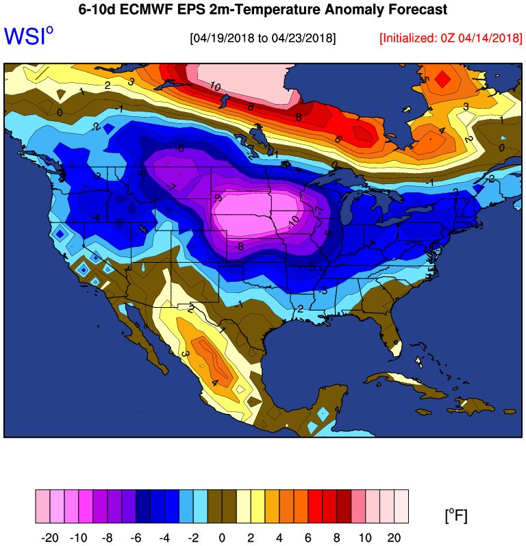
April 2018- April To End Cooler/Drier Than Normal
At a car show in Baytown. It is raining with thunder - Cole and wind at. Looks like more rain per the radar!
The weather can stay like this year round as far as I'm concerned. Who looks forward to the oppressive summers we have?jojotheidiotclown wrote:When the heck is the temps going to stabilize and start climbing? These cold snaps are crappy.
-
srainhoutx

- Site Admin

- Posts: 19616
- Joined: Tue Feb 02, 2010 2:32 pm
- Location: Maggie Valley, NC
- Contact:
Here come the sun and look out for those chilly overnight/early morning temperatures on Sunday!
- Attachments
-
Carla/Alicia/Jerry(In The Eye)/Michelle/Charley/Ivan/Dennis/Katrina/Rita/Wilma/Humberto/Ike/Harvey
Member: National Weather Association
Facebook.com/Weather Infinity
Twitter @WeatherInfinity
Member: National Weather Association
Facebook.com/Weather Infinity
Twitter @WeatherInfinity
Rain can stop any day now!!!!! Woyld like to get some things done....this is for the birds!!!


Finished with .86”. I’m very pleased and looking forward to some beautiful weather the next few days.
-
Texaspirate11

- Posts: 1278
- Joined: Tue Dec 31, 2013 12:24 am
- Contact:
My son is sitting in Minneapolis so I shouldn't complain that I'm cold at 47 degrees this morning....
Just because you're disabled, you don't have to be a victim
Be Weather Aware & Prepared!
Barbara Jordan Winner in Media
Disability Integration Consultant
Be Weather Aware & Prepared!
Barbara Jordan Winner in Media
Disability Integration Consultant
-
srainhoutx
- Site Admin
- Posts: 19616
- Joined: Tue Feb 02, 2010 2:32 pm
- Location: Maggie Valley, NC
- Contact:
Just a bit chilly in NW Harris County early this morning with a temperature in my backyard of 45F. Breezy cool winds will bring a beautiful day, so enjoy it!
The week ahead looks very progressive with a semi zonal flow across the Nation. A weak disturbance and a weak cool front nears our Region Wednesday with little fanfair and should wash out without any meaningful chance of rain.
Things do get a bit more interesting in the Weather Department next week as a much strong upper air low and a much more Southerly tracking system than last Friday/Yesterday organizes and moves toward the Panhandle/Western Oklahoma. While their is some uncertainty as always beyond day 3 to 5, the ensembles are in rather good agreement suggesting the potential for severe weather across West Texas and the Panhandle. The SPC has outlined a Day 6 Risk Area for that potion of the State. With a the main energy source being much closer to our Region this coming weekend, perhaps we will see a better atmospheric environment for rainfall, but the increase in rain may mean a severe weather threat as well. Stay Tuned!
- Attachments
-
-
Carla/Alicia/Jerry(In The Eye)/Michelle/Charley/Ivan/Dennis/Katrina/Rita/Wilma/Humberto/Ike/Harvey
Member: National Weather Association
Facebook.com/Weather Infinity
Twitter @WeatherInfinity
Member: National Weather Association
Facebook.com/Weather Infinity
Twitter @WeatherInfinity


CFSv2 May forecast.
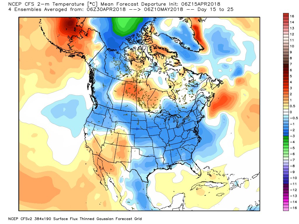
May is two weeks from now and CFSv2 has a cooler May.
May is two weeks from now and CFSv2 has a cooler May.
-
srainhoutx
- Site Admin
- Posts: 19616
- Joined: Tue Feb 02, 2010 2:32 pm
- Location: Maggie Valley, NC
- Contact:
71 years ago this morning the Texas City Disaster began unfolding as the S. S. Grandcamp exploded in the Port of Texas City at 9:02 AM setting off a chain reaction of explosions throughout the day into the next that killed nearly 600 people and seriously injured around 3500. The explosions were felt across Houston with windows blown out in DT Houston and was felt as far away as Louisiana. Some of our parents knew someone killed/injured in the explosions and many responded to assist Texas City in its worst disaster to date.
http://www.texascity-library.org/disaster/first.php
http://www.texascity-library.org/disaster/first.php
Carla/Alicia/Jerry(In The Eye)/Michelle/Charley/Ivan/Dennis/Katrina/Rita/Wilma/Humberto/Ike/Harvey
Member: National Weather Association
Facebook.com/Weather Infinity
Twitter @WeatherInfinity
Member: National Weather Association
Facebook.com/Weather Infinity
Twitter @WeatherInfinity
-
MontgomeryCoWx

- Posts: 2356
- Joined: Wed Dec 14, 2011 4:31 pm
- Location: Weimar, TX
- Contact:
Ptarmigan wrote:CFSv2 May forecast.
May is two weeks from now and CFSv2 has a cooler May.
NICE!
Team #NeverSummer
-
srainhoutx
- Site Admin
- Posts: 19616
- Joined: Tue Feb 02, 2010 2:32 pm
- Location: Maggie Valley, NC
- Contact:
Monday morning briefing from Jeff:
powerful storm system will arrive across TX late this week/early this weekend.
Extremely nice mid April weather will continue today and tomorrow before a weak cool front slides into the area on Wednesday and stalls near the coast on Thursday. Strong capping aloft during this period should prevent much in the way of thunderstorms, but a few scattered showers will be possible from Wednesday afternoon through Thursday over the region. The front will wash out late Thursday with onshore flow developing Thursday night.
Main forecast focus this week will be on the late week/weekend time period as a strong storm system looks poised to impact the region. It should be understood that we are still several days away from any impacts and the forecast will change, but decent global model consistency is pointing toward a very active period late Friday into much of Saturday over the area. Moisture values will rise to impressive mid April levels and the jet stream structure over SE TX looks mostly favorable for strong lifting along an advancing frontal boundary. Severe thunderstorms and heavy rainfall look possible with this system given it will be further south than the recent systems to slide just NE of our area. This system deserves close watch as we move through the week.
Carla/Alicia/Jerry(In The Eye)/Michelle/Charley/Ivan/Dennis/Katrina/Rita/Wilma/Humberto/Ike/Harvey
Member: National Weather Association
Facebook.com/Weather Infinity
Twitter @WeatherInfinity
Member: National Weather Association
Facebook.com/Weather Infinity
Twitter @WeatherInfinity
-
Andrew
- Site Admin
- Posts: 3440
- Joined: Wed Feb 03, 2010 9:46 pm
- Location: North-West Houston
- Contact:
Definitely keeping an eye on this weekend system. ECMWF is the most aggressive with the parameterization but GFS is slowly coming around.
For Your Infinite Source For All Things Weather Visit Our Facebook
-
srainhoutx
- Site Admin
- Posts: 19616
- Joined: Tue Feb 02, 2010 2:32 pm
- Location: Maggie Valley, NC
- Contact:
After our late week/weekend storm system, the afternoon Updated Climate Prediction Center Day 6 to 10 Outlook suggests spectacular weather for late April.
- Attachments
-
-
Carla/Alicia/Jerry(In The Eye)/Michelle/Charley/Ivan/Dennis/Katrina/Rita/Wilma/Humberto/Ike/Harvey
Member: National Weather Association
Facebook.com/Weather Infinity
Twitter @WeatherInfinity
Member: National Weather Association
Facebook.com/Weather Infinity
Twitter @WeatherInfinity
It was a beautiful day indeed! In a perfect world we would have 5 days in a row like today, then one day of rain, then repeated.Katdaddy wrote:Nice weather across SE TX today.
-
srainhoutx
- Site Admin
- Posts: 19616
- Joined: Tue Feb 02, 2010 2:32 pm
- Location: Maggie Valley, NC
- Contact:
The weekend continues to look unsettled with a bowling ball vertically stacked mid/upper low tracking across Texas with a bit of a negative tilt in the trough axis suggesting a better chance of the possibility of seeing strong to severe storms Saturday into early Sunday before the next vigorous cold front sweeps off the Coast. The Storm Prediction Center has Outlined a potential Risk Area across S Central and Central Texas including the Brazos Valley Region. Unlike our past several severe weather events, this one looks much further South and also to our West instead of well to our N and NE.
- Attachments
-
-
-
Carla/Alicia/Jerry(In The Eye)/Michelle/Charley/Ivan/Dennis/Katrina/Rita/Wilma/Humberto/Ike/Harvey
Member: National Weather Association
Facebook.com/Weather Infinity
Twitter @WeatherInfinity
Member: National Weather Association
Facebook.com/Weather Infinity
Twitter @WeatherInfinity
Here we go again...from the local NWS office:
We will have to monitor this frontal passage for potential of both severe weather and locally heavy rain, but
at this time the biggest areas of concern for both look to just miss our area.
unless everything lines up just right, it`s not likely to be a high enough chance to go against basically every model.
I start getting nervous when the NWS has to use the word "still" in their discussions. 90% of the time it's hanging onto the false hope of old model runs.Still think we have the ingredients out there for locally heavy rain and isolated minor flooding issues, but that`s only if they come together just right and right now the models are suggesting that things will be off just enough to give us decent rain, but keep things from getting out of hand. We may just have too narrow a moisture axis, too progressive a front, and maybe even falling under the wrong part of the jet...