
getting pretty dark here, need to turn on some lightsDoctorMu wrote:The heavy band is closing in on Cypress from the NW.
MARCH 2018 - Pleasant Good Friday/Easter Weekend Ahead
that is awesome, so well deserved !srainhoutx wrote:Thought I would post this here since the Topic is active. Jeff and his family are in Orlando for the National Hurricane Conference and as you see, his heart and concern is here in Houston. He just received an Awesome Award and it is very well deserved for those of us that know and partner with Jeff and the Public that he has dedicated his life protecting. Well Done my friend!
Jeff LindnerVerified account @JeffLindner1 · 44m44 minutes ago
Honored to be nominated for the Outstanding Achievement Award by the National Hurricane Conference. This is for all those partnerships that worked so hard to provide life saving information during Harvey @NWSHouston @ReadyHarris @hcfcd @USGS @TxDOTHoustonPIO

Temp has dropped 10 degrees here in the last hour, down to 64 with winds gusting from the north. Rain is getting heavier with some thunder.
Looks like there is some rotation just NW of Katy. Just got a T-storm warning on it.
-
srainhoutx

- Site Admin

- Posts: 19616
- Joined: Tue Feb 02, 2010 2:32 pm
- Location: Maggie Valley, NC
- Contact:
Pea sized hail in NW Harris County now
Carla/Alicia/Jerry(In The Eye)/Michelle/Charley/Ivan/Dennis/Katrina/Rita/Wilma/Humberto/Ike/Harvey
Member: National Weather Association
Facebook.com/Weather Infinity
Twitter @WeatherInfinity
Member: National Weather Association
Facebook.com/Weather Infinity
Twitter @WeatherInfinity
-
Texaspirate11

- Posts: 1278
- Joined: Tue Dec 31, 2013 12:24 am
- Contact:
CONGRATULATIONS!unome wrote:srainhoutx wrote:Thought I would post this here since the Topic is active. Jeff and his family are in Orlando for the National Hurricane Conference and as you see, his heart and concern is here in Houston. He just received an Awesome Award and it is very well deserved for those of us that know and partner with Jeff and the Public that he has dedicated his life protecting. Well Done my friend!
Jeff LindnerVerified account @JeffLindner1 · 44m44 minutes ago
Honored to be nominated for the Outstanding Achievement Award by the National Hurricane Conference. This is for all those partnerships that worked so hard to provide life saving information during Harvey @NWSHouston @ReadyHarris @hcfcd @USGS @TxDOTHoustonPIO
Just because you're disabled, you don't have to be a victim
Be Weather Aware & Prepared!
Barbara Jordan Winner in Media
Disability Integration Consultant
Be Weather Aware & Prepared!
Barbara Jordan Winner in Media
Disability Integration Consultant

-
srainhoutx
- Site Admin
- Posts: 19616
- Joined: Tue Feb 02, 2010 2:32 pm
- Location: Maggie Valley, NC
- Contact:
BULLETIN - EAS ACTIVATION REQUESTED
Tornado Warning
National Weather Service Houston/Galveston TX
530 PM CDT WED MAR 28 2018
The National Weather Service in League City has issued a
* Tornado Warning for...
North central Harris County in southeastern Texas...
* Until 545 PM CDT.
* At 530 PM CDT, a severe thunderstorm capable of producing a tornado
was located over Greater Greenspoint, moving east at 30 mph.
HAZARD...Tornado.
SOURCE...Radar indicated rotation.
IMPACT...Flying debris will be dangerous to those caught without
shelter. Mobile homes will be damaged or destroyed.
Damage to roofs, windows, and vehicles will occur. Tree
damage is likely.
* This dangerous storm will be near...
Northwestern Bush Intercontinental Airport around 540 PM CDT.
Carla/Alicia/Jerry(In The Eye)/Michelle/Charley/Ivan/Dennis/Katrina/Rita/Wilma/Humberto/Ike/Harvey
Member: National Weather Association
Facebook.com/Weather Infinity
Twitter @WeatherInfinity
Member: National Weather Association
Facebook.com/Weather Infinity
Twitter @WeatherInfinity
that was a nice hard shower, just what we needed to clean the pollen away
https://www.harriscountyfws.org/
https://www.harriscountyfws.org/
Lucky you!! Here I am down in Richmond and nada.. guess I’ll have to water the lawnunome wrote:that was a nice hard shower, just what we needed to clean the pollen away
https://www.harriscountyfws.org/
-
Texaspirate11
- Posts: 1278
- Joined: Tue Dec 31, 2013 12:24 am
- Contact:
Still patiently waiting by the Bay
We're just supplying all the energy from the GOM...
stay safe everyone...
We're just supplying all the energy from the GOM...
stay safe everyone...
Just because you're disabled, you don't have to be a victim
Be Weather Aware & Prepared!
Barbara Jordan Winner in Media
Disability Integration Consultant
Be Weather Aware & Prepared!
Barbara Jordan Winner in Media
Disability Integration Consultant
Keep an eye on that discrete cell blowing up near Alvin.
-
Katdaddy

- Global Moderator

- Posts: 2502
- Joined: Thu Feb 04, 2010 8:18 am
- Location: League City, Tx
- Contact:
BULLETIN - EAS ACTIVATION REQUESTED
Tornado Warning
National Weather Service Houston/Galveston TX
530 PM CDT WED MAR 28 2018
The National Weather Service in League City has issued a
* Tornado Warning for...
North central Harris County in southeastern Texas...
* Until 545 PM CDT.
* At 530 PM CDT, a severe thunderstorm capable of producing a tornado
was located over Greater Greenspoint, moving east at 30 mph.
HAZARD...Tornado.
SOURCE...Radar indicated rotation.
IMPACT...Flying debris will be dangerous to those caught without
shelter. Mobile homes will be damaged or destroyed.
Damage to roofs, windows, and vehicles will occur. Tree
damage is likely.
* This dangerous storm will be near...
Northwestern Bush Intercontinental Airport around 540 PM CDT.
PRECAUTIONARY/PREPAREDNESS ACTIONS...
TAKE COVER NOW! Move to a basement or an interior room on the lowest
floor of a sturdy building. Avoid windows. If you are outdoors, in a
mobile home, or in a vehicle, move to the closest substantial shelter
and protect yourself from flying debris.
https://twitter.com/iembot_hgx
https://twitter.com/iembot_spc
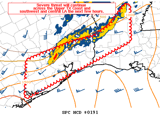
Mesoscale Discussion 0191
NWS Storm Prediction Center Norman OK
0548 PM CDT Wed Mar 28 2018
Areas affected...the Upper Texas Coast into southwest and central
Louisiana
Concerning...Tornado Watch 22...
Valid 282248Z - 290015Z
The severe weather threat for Tornado Watch 22 continues.
SUMMARY...Gradual weakening is expected into the early evening
hours. An isolated strong to severe storm is still possible where
Tornado Watch 22 remains in effect across the Upper Texas Coast into
parts of southwest and central LA.
DISCUSSION...A line of storms stretched from near Houston to Fort
Polk LA, then northeast toward far northeastern LA late this
afternoon. A southeastward surging gust front has largely resulted
in weakening of convection in the Sabine Valley vicinity with some
stronger cells still evident just north of Houston and to the east
of Fort Polk. Regional VWP data shows adequate low level shear for
rotating structures, but instability has begun to wane as peak
heating has passed. Given the overall convective trends over the
last hour, continued weakening is expected. However, an isolated
strong to severe storm along or ahead of the outflow boundary cannot
be ruled out and Tornado Watch 22 will continue across the Upper
Texas Coast into parts of southwest and central LA.
..Leitman.. 03/28/2018
...Please see http://www.spc.noaa.gov for graphic product...
ATTN...WFO...LCH...SHV...HGX...CRP...EWX...
https://twitter.com/iembot_spc
Mesoscale Discussion 0191
NWS Storm Prediction Center Norman OK
0548 PM CDT Wed Mar 28 2018
Areas affected...the Upper Texas Coast into southwest and central
Louisiana
Concerning...Tornado Watch 22...
Valid 282248Z - 290015Z
The severe weather threat for Tornado Watch 22 continues.
SUMMARY...Gradual weakening is expected into the early evening
hours. An isolated strong to severe storm is still possible where
Tornado Watch 22 remains in effect across the Upper Texas Coast into
parts of southwest and central LA.
DISCUSSION...A line of storms stretched from near Houston to Fort
Polk LA, then northeast toward far northeastern LA late this
afternoon. A southeastward surging gust front has largely resulted
in weakening of convection in the Sabine Valley vicinity with some
stronger cells still evident just north of Houston and to the east
of Fort Polk. Regional VWP data shows adequate low level shear for
rotating structures, but instability has begun to wane as peak
heating has passed. Given the overall convective trends over the
last hour, continued weakening is expected. However, an isolated
strong to severe storm along or ahead of the outflow boundary cannot
be ruled out and Tornado Watch 22 will continue across the Upper
Texas Coast into parts of southwest and central LA.
..Leitman.. 03/28/2018
...Please see http://www.spc.noaa.gov for graphic product...
ATTN...WFO...LCH...SHV...HGX...CRP...EWX...

It was dusk-like during mid-day here.unome wrote:getting pretty dark here, need to turn on some lightsDoctorMu wrote:The heavy band is closing in on Cypress from the NW.

Storms are starting to fire SE of Monterrey in Mexico... we will need to monitor how much development occurs and the movement of them as they move NE/ENE. These could be our overnight boomers. Think those mainly South of I-10 will have to worry about the severe aspect.
Edit to add: Models showed storms firing from this area a couple hours ago. So it is a bit late, though, future trends on the HRRR will be interesting to see if it can catch onto new initialization and the severity of it.
Edit to add: Models showed storms firing from this area a couple hours ago. So it is a bit late, though, future trends on the HRRR will be interesting to see if it can catch onto new initialization and the severity of it.
Blake
Boomer Sooner
Boomer Sooner
still a lot of juice there
http://weather.cod.edu/satrad/exper/?pa ... hecked=map
http://weather.cod.edu/satrad/exper/?pa ... hecked=map
http://weather.cod.edu/satrad/exper/?pa ... hecked=map
http://weather.cod.edu/satrad/exper/?pa ... hecked=map
http://www.spc.ncep.noaa.gov/products/md/

Mesoscale Discussion 0192
NWS Storm Prediction Center Norman OK
0653 PM CDT Wed Mar 28 2018
Areas affected...South Texas
Concerning...Severe potential...Watch possible
Valid 282353Z - 290130Z
Probability of Watch Issuance...40 percent
SUMMARY...Storms may develop across South Texas this evening, with
large hail the main threat. A more likely threat will evolve later
tonight as a storms develop along a southward advancing cold front.
Convective trends are being monitored and a watch may be needed at
some point over the next several hours this evening.
DISCUSSION...Weak convergence was evident across South Texas both in
surface observations and band of cumulus from Duval to Starr county
into adjacent portions of northeast Mexico. Hi-res guidance has been
persistent in storm development early this evening in the vicinity
of this boundary in a weakly capped moderately unstable environment.
However, guidance has been quicker and more robust with this
development than is currently being observed, resulting in quite a
bit of uncertainty. Should storms develop across South Texas or move
into this region from adjacent portions of Mexico, large hail will
be the main concern given steep midlevel lapse rates and strong
deep-layer shear profiles. A glance at area VWP data indicates only
weak helicity values with light winds through about 3km. This should
temper any tornado threat.
While uncertainty remains high in the short-term, it appears more
likely that storms will develop later tonight as forcing for ascent
increases in conjunction with a southward advancing cold front. At
this time, it is unclear when a watch may be needed and trends will
be monitored closely.
..Leitman/Guyer.. 03/28/2018
...Please see http://www.spc.noaa.gov for graphic product...
ATTN...WFO...CRP...BRO...
http://weather.cod.edu/satrad/exper/?pa ... hecked=map
http://weather.cod.edu/satrad/exper/?pa ... hecked=map
http://weather.cod.edu/satrad/exper/?pa ... hecked=map
http://weather.cod.edu/satrad/exper/?pa ... hecked=map
http://www.spc.ncep.noaa.gov/products/md/
Mesoscale Discussion 0192
NWS Storm Prediction Center Norman OK
0653 PM CDT Wed Mar 28 2018
Areas affected...South Texas
Concerning...Severe potential...Watch possible
Valid 282353Z - 290130Z
Probability of Watch Issuance...40 percent
SUMMARY...Storms may develop across South Texas this evening, with
large hail the main threat. A more likely threat will evolve later
tonight as a storms develop along a southward advancing cold front.
Convective trends are being monitored and a watch may be needed at
some point over the next several hours this evening.
DISCUSSION...Weak convergence was evident across South Texas both in
surface observations and band of cumulus from Duval to Starr county
into adjacent portions of northeast Mexico. Hi-res guidance has been
persistent in storm development early this evening in the vicinity
of this boundary in a weakly capped moderately unstable environment.
However, guidance has been quicker and more robust with this
development than is currently being observed, resulting in quite a
bit of uncertainty. Should storms develop across South Texas or move
into this region from adjacent portions of Mexico, large hail will
be the main concern given steep midlevel lapse rates and strong
deep-layer shear profiles. A glance at area VWP data indicates only
weak helicity values with light winds through about 3km. This should
temper any tornado threat.
While uncertainty remains high in the short-term, it appears more
likely that storms will develop later tonight as forcing for ascent
increases in conjunction with a southward advancing cold front. At
this time, it is unclear when a watch may be needed and trends will
be monitored closely.
..Leitman/Guyer.. 03/28/2018
...Please see http://www.spc.noaa.gov for graphic product...
ATTN...WFO...CRP...BRO...
-
Texaspirate11
- Posts: 1278
- Joined: Tue Dec 31, 2013 12:24 am
- Contact:
Hoping to get something if just to wash the pollen away....
Just because you're disabled, you don't have to be a victim
Be Weather Aware & Prepared!
Barbara Jordan Winner in Media
Disability Integration Consultant
Be Weather Aware & Prepared!
Barbara Jordan Winner in Media
Disability Integration Consultant
Texaspirate11 wrote:Hoping to get something if just to wash the pollen away....
Same here! Hopefully the mesoscale models are right, there’s a lot left to provide us south of the I-10 corridor later tonight.
2.22” here so far. I’m so glad to see the pollen finally wash away. Watching the new development out to the west and southwest...looks rather impressive so far.
-
- Information
-
Who is online
Users browsing this forum: Ahrefs [Bot], Amazon [Bot], cperk, Cromagnum, Semrush [Bot], TexasBreeze and 58 guests