
August 2017: Looking Back at Harvey 5 Year Later
-
TexasBreeze
- Posts: 942
- Joined: Sun Sep 26, 2010 4:46 pm
- Location: NW Houston, TX
- Contact:
I would say the low could shear out and continue southeastward due to the building high from the west.
-
Texaspirate11

- Posts: 1278
- Joined: Tue Dec 31, 2013 12:24 am
- Contact:
Flood Watch
National Weather Service Houston/Galveston TX
844 PM CDT Tue Aug 8 2017
Galveston-
Including the cities of Friendswood, Galveston, League City,
and Texas City
844 PM CDT Tue Aug 8 2017
...FLASH FLOOD WATCH IN EFFECT UNTIL 8 AM CDT WEDNESDAY...
The National Weather Service in Houston/Galveston has expanded
the
* Flash Flood Watch to include a portion of southeast Texas...
including the following county...Galveston.
* Until 8 AM CDT Wednesday
* Shower and thunderstorm coverage is expected to increase across
portions of the watch area overnight. Storms that repeatably
move over the same locations have the potential to produce
rainfall rates of up to 3 inches per hour which could lead to
flooding.
PRECAUTIONARY/PREPAREDNESS ACTIONS...
Do not drive your vehicle into areas where the water covers the
roadway. The water depth may be too great to allow your car to
cross safely. Vehicles caught in rising water should be abandoned
quickly. If your vehicle stalls...abandon it and seek higher ground
immediately. Rapidly rising water may engulf your vehicle and its
occupants and sweep them away. Move to higher ground.
A Flash Flood Watch means that conditions may develop that lead
to flash flooding. Flash flooding is a very dangerous situation.
You should monitor later forecasts and be prepared to take action
should Flash Flood Warnings be issued.
Just because you're disabled, you don't have to be a victim
Be Weather Aware & Prepared!
Barbara Jordan Winner in Media
Disability Integration Consultant
Be Weather Aware & Prepared!
Barbara Jordan Winner in Media
Disability Integration Consultant
-
Katdaddy

- Global Moderator

- Posts: 2502
- Joined: Thu Feb 04, 2010 8:18 am
- Location: League City, Tx
- Contact:
A Flash Flood Watch is in effect until 8AM Wednesday morning for the SE portion of SETX including the Houston-Galveston areas. We just a very isolated but very heavy shower in W League City.
- Attachments
-

Thankfully for Houston, not much widespread rain tonight for the metro. The heaviest stuff with be off to the East over areas that can handle it. If it were to come to the metro, it would be no bueno as creeks are full and grounds are saturated.
A transplant from Houston to Lincoln, Nebraska.

BULLETIN - EAS ACTIVATION REQUESTED
Flash Flood Warning
National Weather Service Houston/Galveston TX
146 AM CDT WED AUG 9 2017
The National Weather Service in League City has issued a
* Flash Flood Warning for...
Central Galveston County in southeastern Texas...
* Until 345 AM CDT.
* At 145 AM CDT, Doppler radar indicated thunderstorms producing
heavy rain across the warned area. 3 inches of rain have fallen.
Flash flooding is expected to begin shortly.
* Some locations that will experience flooding include...
Galveston Island West End, Galveston Causeway, Schlitterbahn,
Scholes Field, Moody Gardens and Offatts Bayou.
PRECAUTIONARY/PREPAREDNESS ACTIONS...
Turn around, don`t drown when encountering flooded roads. Most flood
deaths occur in vehicles.
Be especially cautious at night when it is harder to recognize the
dangers of flooding.
~~~When Thunder Roars Go Indoors~~~
~~~Turn Around Don't Drown~~~
~~~Run From The Water, Hide From The Wind~~~
~~~Turn Around Don't Drown~~~
~~~Run From The Water, Hide From The Wind~~~
-
srainhoutx

- Site Admin

- Posts: 19616
- Joined: Tue Feb 02, 2010 2:32 pm
- Location: Maggie Valley, NC
- Contact:
Rain chances should begin to diminish today as that pesky mid level warmed core low that meandered over our Region fills in and moves East.
Meanwhile down in the Bay of Campeche, Franklin is strengthening rather quickly and is near becoming a Hurricane. Reconnaissance Aircraft is currently sampling the Storm and has found lower pressures (987mb) at the center of the circulation and winds of 70 MPH.
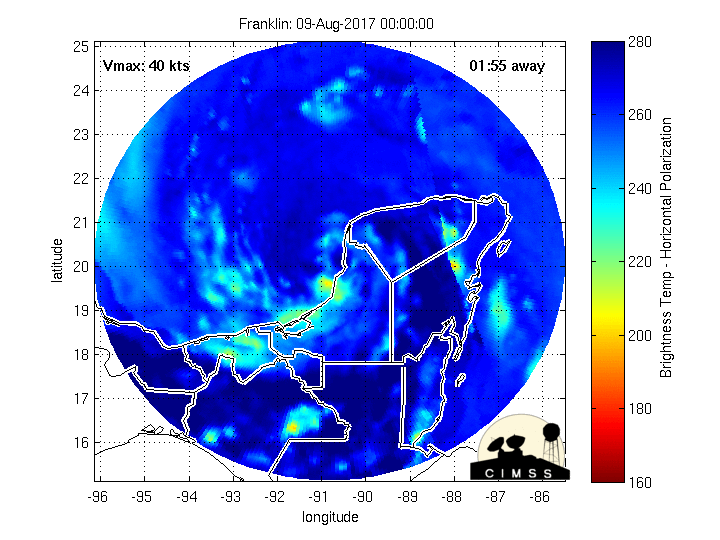
Meanwhile down in the Bay of Campeche, Franklin is strengthening rather quickly and is near becoming a Hurricane. Reconnaissance Aircraft is currently sampling the Storm and has found lower pressures (987mb) at the center of the circulation and winds of 70 MPH.
- Attachments
-
-
-
Carla/Alicia/Jerry(In The Eye)/Michelle/Charley/Ivan/Dennis/Katrina/Rita/Wilma/Humberto/Ike/Harvey
Member: National Weather Association
Facebook.com/Weather Infinity
Twitter @WeatherInfinity
Member: National Weather Association
Facebook.com/Weather Infinity
Twitter @WeatherInfinity
-
srainhoutx
- Site Admin
- Posts: 19616
- Joined: Tue Feb 02, 2010 2:32 pm
- Location: Maggie Valley, NC
- Contact:
Hurricane Franklin Discussion Number 13
NWS National Hurricane Center Miami FL AL072017
400 PM CDT Wed Aug 09 2017
Hurricane Hunter aircraft observations from earlier today indicated
that Franklin was very close to hurricane strength. Since the time
of the last mission, the system has become better organized, with a
faint eye occasionally making an appearance on visible satellite
images. Dvorak intensity estimates from both TAFB and SAB are 65
kt and this value will be used for the advisory intensity, making
Franklin the first hurricane of the season. There is some northerly
shear evident over the system and with several arc clouds evident
over the outer circulation's northwest quadrant, perhaps some dry
air is nearby. These environmental conditions are not expected to
be detrimental enough, however, to prevent at least some additional
strengthening before landfall tonight. An Air Force Hurricane
Hunter aircraft is scheduled to investigate Franklin a few hours
from now to check the strength of the cyclone.
The hurricane continues to move westward, with the initial motion
estimated to be 270/10. There are essentially no changes to the
track forecast or reasoning. The flow on the southern side of a
mid-level high pressure area near the Texas coast should continue
to steer Franklin towards, and across, the southwest Gulf coast of
Mexico. The official track forecast follows the latest dynamical
track model consensus.
FORECAST POSITIONS AND MAX WINDS
INIT 09/2100Z 20.1N 94.9W 65 KT 75 MPH
12H 10/0600Z 19.8N 96.6W 75 KT 85 MPH...INLAND
24H 10/1800Z 19.3N 99.5W 30 KT 35 MPH...INLAND
36H 11/0600Z...DISSIPATED
$$
Forecaster Pasch
- Attachments
-
Carla/Alicia/Jerry(In The Eye)/Michelle/Charley/Ivan/Dennis/Katrina/Rita/Wilma/Humberto/Ike/Harvey
Member: National Weather Association
Facebook.com/Weather Infinity
Twitter @WeatherInfinity
Member: National Weather Association
Facebook.com/Weather Infinity
Twitter @WeatherInfinity
-
Katdaddy
- Global Moderator
- Posts: 2502
- Joined: Thu Feb 04, 2010 8:18 am
- Location: League City, Tx
- Contact:
Hot and humid weather has returned across SE TX. From the HOU-GAL NWS:
...Dangerous heat index values possible this afternoon...
Dangerous heat indices of 105-109 are forecast this afternoon, generally along and south of the I-10 corridor. A heat advisory may be required for this afternoon.
Please practice good heat safety today by staying hydrated and using caution when working outdoors. Know the signs of heat stress and seek medical attention if you suspect that you or someone else is experiencing heat illness.

Stay inside if you can. Dewpoint is out of control right now = 78°F in CLL. Heat index today and tomorrow could approach 110°F here. A boring August WX forecast ahead for the next week.
Area Forecast Discussion
National Weather Service Houston/Galveston TX
616 AM CDT Thu Aug 10 2017
.DISCUSSION...
Some patchy fog at KLBX and KCXO has produced some brief MVFR
conditions, but the fog is shallow and should burn off between
13-14z. The HRRR is bullish with rain chances today along a
developing sea breeze boundary. Fcst soundings show PW values
between 2.00 and 2.10 inches but the moisture profile looks dry.
A weak cap was noted near 850 mb, but the cap looks breakable
with heating. Have kept the VCTS for areas for southern TAF sites
but have removed the mention of precip from KCLL, KUTS and KCXO.
VFR conditions expected tonight with some patchy fog again
possible at KCXO/KLBX toward sunrise. 43
&&
.PREV DISCUSSION... /ISSUED 332 AM CDT Thu Aug 10 2017/
DISCUSSION...
A passing shower or two along with some patchy fog will be
possible early this morning, primarily across the Piney Woods
region. Ridging begins to take hold of the forecast today, helping
us return to a more typical summertime pattern. Could still get
some scattered showers and storms both today and Friday, primarily
along the sea breeze. Rain chances become more limited heading
into the weekend as the ridge remains overhead. With the lowering
chances for showers/storms, high temperatures will be on the rise
for much of the forecast period, generally ranging from the upper
80s right along the coast to the mid/upper 90s across the Brazos
Valley. Light to moderate south to southeasterly flow throughout
the upcoming week will keep humidity high, allowing heat index
values to surge into the 103-109 degree range during the
afternoons. Right now, Friday and Saturday are forecast to have
the highest heat index values, and heat advisories may be
required.
-
srainhoutx
- Site Admin
- Posts: 19616
- Joined: Tue Feb 02, 2010 2:32 pm
- Location: Maggie Valley, NC
- Contact:
If working outdoors, take frequent breaks and stay hydrated...
URGENT - WEATHER MESSAGE
National Weather Service Houston/Galveston TX
419 AM CDT Fri Aug 11 2017
...Heat Advisory in Effect...
.Very warm temperatures coupled with high humidity will produce
heat index values between 106 and 110 degrees this afternoon.
Heat illnesses are possible if precautions are not taken.
Austin-Brazoria-Brazos-Burleson-Chambers-Colorado-Fort Bend-
Galveston-Grimes-Harris-Jackson-Matagorda-Montgomery-Waller-
Washington-Wharton-
Including the cities of Alvin, Anahuac, Angleton, Bay City,
Bellville, Brenham, Brookshire, Bryan, Caldwell, College Station,
Columbus, Conroe, Eagle Lake, Edna, El Campo, Freeport,
Friendswood, Galveston, Hempstead, Houston, Humble, Katy,
Lake Jackson, Lake Somerville, League City, Missouri City,
Mont Belvieu, Navasota, Palacios, Pasadena, Pearland, Pierce,
Prairie View, Richmond, Rosenberg, Sealy, Sugar Land, Texas City,
The Woodlands, Tomball, Weimar, Wharton, Willis, and Winnie
419 AM CDT Fri Aug 11 2017
...HEAT ADVISORY IN EFFECT FROM 1 PM THIS AFTERNOON TO 7 PM CDT
THIS EVENING...
The National Weather Service in Houston/Galveston has issued a
Heat Advisory, which is in effect from 1 PM this afternoon to
7 PM CDT this evening.
* EVENT...Heat index values 106 to 110 degrees across the all of
the advisory area.
* TIMING...This afternoon into the early evening.
* IMPACT...Prolonged exposure to the heat and/or exertion outdoors
without proper hydration and other precautionary actions may
result in heat exhaustion or heat stroke.
PRECAUTIONARY/PREPAREDNESS ACTIONS...
Take extra precautions if you work or spend time outside. When
possible...reschedule strenuous activities to early morning or
evening. Know the signs and symptoms of heat exhaustion and heat
stroke. Wear light weight and loose fitting clothing when
possible and drink plenty of water.
To reduce risk during outdoor work...the occupational safety and
health administration recommends scheduling frequent rest breaks
in shaded or air conditioned environments. Anyone overcome by
heat should be moved to a cool and shaded location. Heat stroke
is an emergency - call 911.
Each year...a number of fatalities occur nationwide due to
children accidentally being left in vehicles during the summer
months. In the past dozen years...500 children have died due to
hyperthermia after being left in or gaining access to cars. Never
leave children or pets unattended in a vehicle not even for a
minute. Remember...beat the heat...check the backseat.
Carla/Alicia/Jerry(In The Eye)/Michelle/Charley/Ivan/Dennis/Katrina/Rita/Wilma/Humberto/Ike/Harvey
Member: National Weather Association
Facebook.com/Weather Infinity
Twitter @WeatherInfinity
Member: National Weather Association
Facebook.com/Weather Infinity
Twitter @WeatherInfinity
-
srainhoutx
- Site Admin
- Posts: 19616
- Joined: Tue Feb 02, 2010 2:32 pm
- Location: Maggie Valley, NC
- Contact:
While the Tropics have quieted down for the time being, there are indications that the Hemispheric Pattern could become very favorable for Tropical Development in about a week to 10 days. We are likely to see a big increase in tropical wave activity developing across Africa as the Convectively Coupled Kelvin Wave that assisted Franklin to form shifts over Africa and the Indian Ocean. The Madden Julian Oscillation appears to strengthen across the Indian Ocean increasing odds in the Atlantic Basin for the possibilities of Tropical Troubles to organize.
Michael VentriceVerified account @MJVentrice · 23m23 minutes ago
When the MJO is located over the Indian Ocean (Blue shading), there's a 4x more likelihood for Hurricanes over the Atlantic Basin
NOAA has increased to their numbers for Tropical Storms and Hurricanes in their latest Update as of August 9th:
UPDATED: August 9, 2017. Audio from today's media call is posted to the "Resources" section below.
August 9, 2017 — Today NOAA issued the scheduled update for its 2017 hurricane season outlook. Forecasters are now predicting a higher likelihood of an above-normal season, and they increased the predicted number of named storms and major hurricanes. The season has the potential to be extremely active, and could be the most active since 2010.
Forecasters now say there is a 60-percent chance of an above-normal season (compared to the May prediction of 45 percent chance), with 14-19 named storms (increased from the May predicted range of 11-17) and 2-5 major hurricanes (increased from the May predicted range of 2-4). A prediction for 5-9 hurricanes remains unchanged from the intial May outlook.
“We’re now entering the peak of the season when the bulk of the storms usually form,” said Gerry Bell, Ph.D., lead seasonal hurricane forecaster at NOAA’s Climate Prediction Center. “The wind and air patterns in the area of the tropical Atlantic and Caribbean where many storms develop are very conducive to an above-normal season. This is in part because the chance of an El Nino forming, which tends to prevent storms from strengthening, has dropped significantly from May.”
Bell noted other factors that point to an above-normal season include warmer waters across the tropical Atlantic than models previously predicted and higher predicted activity from available models.
In just the first nine weeks of this season there have been six named storms, which is half the number of storms during an average six-month season and double the number of storms that would typically form by early August. An average Atlantic hurricane season, which runs from June 1-November 30, produces 12 named storms, of which six become hurricanes, including three major hurricanes.
“Today’s updated outlook underscores the need for everyone to know their true vulnerabilities to storms and storm surge,” said FEMA Administrator Brock Long. “As we enter the height of hurricane season, it’s important for everyone to know who issues evacuation orders in their community, heed the warnings, update their insurance and have a preparedness plan.”
The updated outlook is based on the current and evolving atmospheric and oceanic conditions, the most recent model predictions, and pre-and early-season storm activity. The numbers announced today include the season activity to-date. The Atlantic basin has seen six named storms (Arlene in April; Bret and Cindy in June; Don and Emily in July; and Franklin in August). Two of these storms, Cindy and Emily, struck the United States. Cindy made landfall on June 22 at the Louisiana-Texas border and caused heavy rain, inland flooding and multiple tornado outbreaks. Emily made landfall on July 31 in Anna Maria Island, Florida. Franklin is predicted to make landfall in Mexico overnight as a hurricane.
Today’s update also decreases the chance of a near-normal season from 35 percent to 30 percent, and a below-normal season from 20 percent to only 10 percent from the initial outlook issued in May.
As we move into the peak of hurricane season, when hurricanes are most frequent and at their strongest, NOAA urges coastal residents to make sure they have their hurricane preparedness plans in place and to monitor the latest forecasts.
[/i]
Michael VentriceVerified account @MJVentrice · 23m23 minutes ago
When the MJO is located over the Indian Ocean (Blue shading), there's a 4x more likelihood for Hurricanes over the Atlantic Basin
NOAA has increased to their numbers for Tropical Storms and Hurricanes in their latest Update as of August 9th:
UPDATED: August 9, 2017. Audio from today's media call is posted to the "Resources" section below.
August 9, 2017 — Today NOAA issued the scheduled update for its 2017 hurricane season outlook. Forecasters are now predicting a higher likelihood of an above-normal season, and they increased the predicted number of named storms and major hurricanes. The season has the potential to be extremely active, and could be the most active since 2010.
Forecasters now say there is a 60-percent chance of an above-normal season (compared to the May prediction of 45 percent chance), with 14-19 named storms (increased from the May predicted range of 11-17) and 2-5 major hurricanes (increased from the May predicted range of 2-4). A prediction for 5-9 hurricanes remains unchanged from the intial May outlook.
Bell noted other factors that point to an above-normal season include warmer waters across the tropical Atlantic than models previously predicted and higher predicted activity from available models.
In just the first nine weeks of this season there have been six named storms, which is half the number of storms during an average six-month season and double the number of storms that would typically form by early August. An average Atlantic hurricane season, which runs from June 1-November 30, produces 12 named storms, of which six become hurricanes, including three major hurricanes.
The updated outlook is based on the current and evolving atmospheric and oceanic conditions, the most recent model predictions, and pre-and early-season storm activity. The numbers announced today include the season activity to-date. The Atlantic basin has seen six named storms (Arlene in April; Bret and Cindy in June; Don and Emily in July; and Franklin in August). Two of these storms, Cindy and Emily, struck the United States. Cindy made landfall on June 22 at the Louisiana-Texas border and caused heavy rain, inland flooding and multiple tornado outbreaks. Emily made landfall on July 31 in Anna Maria Island, Florida. Franklin is predicted to make landfall in Mexico overnight as a hurricane.
Today’s update also decreases the chance of a near-normal season from 35 percent to 30 percent, and a below-normal season from 20 percent to only 10 percent from the initial outlook issued in May.
As we move into the peak of hurricane season, when hurricanes are most frequent and at their strongest, NOAA urges coastal residents to make sure they have their hurricane preparedness plans in place and to monitor the latest forecasts.
[/i]
Carla/Alicia/Jerry(In The Eye)/Michelle/Charley/Ivan/Dennis/Katrina/Rita/Wilma/Humberto/Ike/Harvey
Member: National Weather Association
Facebook.com/Weather Infinity
Twitter @WeatherInfinity
Member: National Weather Association
Facebook.com/Weather Infinity
Twitter @WeatherInfinity

Just had a coworker collapse of heat exhaustion. Please please take precautions when working outside for any given amount of time. It only takes minutes for heat exhaustion to happen. This person was even acclimated to this type of weather. Just go to show that it could be anyone. Thankfully he is ok now but will remain in the hospital overnight. Drink plenty of WATER! Stay in the shade as much as possible. Extreme heat advisory for all of southeast Texas. Heat index here in bmt is currently 112. Heat can kill! Stay safe everyone! Cheers!
Mike
Beaumont, TX
(IH-10 & College Street)
Beaumont, TX
(IH-10 & College Street)
Hearing thunder here in Stafford. Front of the house looks darkish, back of the house is just cloudy. Dang just saw a big lightning bolt on the back side of the house. It is getting a bit windy also. Very loud thunder.
That storm split right over my neighborhood. One went west.... the other went ENE ...and all I got was Thunder and not a drop. Truly the Dog Days of Summer are upon us.
~~~When Thunder Roars Go Indoors~~~
~~~Turn Around Don't Drown~~~
~~~Run From The Water, Hide From The Wind~~~
~~~Turn Around Don't Drown~~~
~~~Run From The Water, Hide From The Wind~~~
All that noise and a lovely breeze and NOT A DROP of rain. Sigh...djjordan wrote:That storm split right over my neighborhood. One went west.... the other went ENE ...and all I got was Thunder and not a drop. Truly the Dog Days of Summer are upon us.
-
srainhoutx
- Site Admin
- Posts: 19616
- Joined: Tue Feb 02, 2010 2:32 pm
- Location: Maggie Valley, NC
- Contact:
Heat Advisories continue today, so stay hydrated. The sensible weather forecast for the week ahead looks a bit murky due to some rather significant differences between the hot and dry GFS solutions versus lowering heights and a couple of weak disturbance traveling West beneath the Upper Ridge across Sputh Texas suggested by the ECMWF solutions. The European model has been performing more closely to reality day to day, so will give its solutions a bit more favorability. Isolated sea/ bay breeze showers and storms may begin to increase throughout the coming week.
In the Tropics, Tropical Depression 8 has formed East of the Bahamas and could become TS Gert passing well offshore of the United States East Coast. With that said there are growing indications that tropical activity may increase over the next week to 10 days. The overnight ECMWF suggests at least 3 potential Tropical Troublemakers on the long range charts.
Michael VentriceVerified account @MJVentrice · 2h2 hours ago
Eyes now turn to the Atlantic's Main Development Region for our next developing tropical cyclone; Models favor a track towards the GoMEX
In the Tropics, Tropical Depression 8 has formed East of the Bahamas and could become TS Gert passing well offshore of the United States East Coast. With that said there are growing indications that tropical activity may increase over the next week to 10 days. The overnight ECMWF suggests at least 3 potential Tropical Troublemakers on the long range charts.
Eyes now turn to the Atlantic's Main Development Region for our next developing tropical cyclone; Models favor a track towards the GoMEX
Carla/Alicia/Jerry(In The Eye)/Michelle/Charley/Ivan/Dennis/Katrina/Rita/Wilma/Humberto/Ike/Harvey
Member: National Weather Association
Facebook.com/Weather Infinity
Twitter @WeatherInfinity
Member: National Weather Association
Facebook.com/Weather Infinity
Twitter @WeatherInfinity
-
srainhoutx
- Site Admin
- Posts: 19616
- Joined: Tue Feb 02, 2010 2:32 pm
- Location: Maggie Valley, NC
- Contact:
Monday morning briefing from Jeff:
Tropical Storm Gert has formed off the east coast of the US and is forecast to become a hurricane while remaining east of the US coast.
91L:
A series of tropical waves have moved off the western coast of Africa extending several hundred miles westward over the Atlantic Ocean. Organization of these waves continues and conditions look favorable for the formation of a tropical cyclone over the next 5 days. It is unclear at the moment which wave may become the dominant system which will likely have implications for track forecasts down the road.
Local:
Area continues to be normally hot for mid August. The past few days have featured a struggle for low level dewpoints to mix out which helped support 107-111 heat index values on Friday and Saturday. Dewpoints mixed out better on Sunday and values maxed out in the 105-107 range. Ridge axis nearby is shifting slightly today and 850mb temperatures has cooled a degree or two, so not expecting widespread 108 heat index readings…hence no advisory.
Yet another rare August frontal boundary has sunk into NE TX overnight along with numerous showers and thunderstorms. Position of jet stream disturbances just north of the region may help to force a few showers and thunderstorms this afternoon and again Tuesday especially as a pool of deeper moisture over the Gulf moves into the area on Tuesday. Wednesday will likely feature the best rain chances of the week (30-40%) with the upper ridge backing off the area slightly cooling mid level temperatures. Will likely see scattered showers and thunderstorms on Wednesday. Ridging builds back over the area Thursday-next week, but is not overly strong so expect to see a continue slightly chance of daily thunderstorms and temperature near normal.
- Attachments
-
Carla/Alicia/Jerry(In The Eye)/Michelle/Charley/Ivan/Dennis/Katrina/Rita/Wilma/Humberto/Ike/Harvey
Member: National Weather Association
Facebook.com/Weather Infinity
Twitter @WeatherInfinity
Member: National Weather Association
Facebook.com/Weather Infinity
Twitter @WeatherInfinity
-
srainhoutx
- Site Admin
- Posts: 19616
- Joined: Tue Feb 02, 2010 2:32 pm
- Location: Maggie Valley, NC
- Contact:
We'll need to monitor the progression of 91L and it makes the trip across the Atlantic over the next 5 to 7 days. We are nearing "Prime Time" in the North Atlantic Basin for Tropical Development according to Climatology and it is also noteworthy that the Hemispheric Pattern Indicators have coincided with the burst of tropical waves marching across Africa and into the Eastern Atlantic Waters. MIMIC clearly shows a wave break associated with the very large area of disturbed weather over the Eastern and Central Atlantic suggesting development may well be delayed before the broad area of disturbed weather can coalesce somewhere near or just beyond 50W.

The Hour 72 NWS/NHC Forecast suggests the board and large Azores/Bermuda Ridge will dominate the steering flow across the Deep Tropics with the Easterly Trade Winds moving 91L generally West around 15 MPH.
Saharan Air Layer is a bit dusty with the lead tropical wave, but is less of an issue where 91L is currently positioned S of the Cabo Verde Islands.
The overnight Ensemble Guidance does suggest TC Genesis may be possible in the 48 to 72 hour time frame and the individual 51 members of the ECMWF Ensembles do suggest a potential threat to the Caribbean Islands by this weekend. Beyond that, there will be a lot of speculation about the future track. While it is possible that a potential threat to the United States Mainland could occur. It is far too soon to know with any certainty where this disturbance make go, particularly before we actually have a Storm to track.
The Hour 72 NWS/NHC Forecast suggests the board and large Azores/Bermuda Ridge will dominate the steering flow across the Deep Tropics with the Easterly Trade Winds moving 91L generally West around 15 MPH.
Carla/Alicia/Jerry(In The Eye)/Michelle/Charley/Ivan/Dennis/Katrina/Rita/Wilma/Humberto/Ike/Harvey
Member: National Weather Association
Facebook.com/Weather Infinity
Twitter @WeatherInfinity
Member: National Weather Association
Facebook.com/Weather Infinity
Twitter @WeatherInfinity
-
srainhoutx
- Site Admin
- Posts: 19616
- Joined: Tue Feb 02, 2010 2:32 pm
- Location: Maggie Valley, NC
- Contact:
Interesting to see a 10 degree shift further West with the 12Z Best Track. The Statistical Guidance for 91L may begin to trend more Westward in time. The Dynamical Guidance (ECMWF/GFS/UKMET/Canadian) probably will not change that much in the near term.
Carla/Alicia/Jerry(In The Eye)/Michelle/Charley/Ivan/Dennis/Katrina/Rita/Wilma/Humberto/Ike/Harvey
Member: National Weather Association
Facebook.com/Weather Infinity
Twitter @WeatherInfinity
Member: National Weather Association
Facebook.com/Weather Infinity
Twitter @WeatherInfinity
-
- Information
-
Who is online
Users browsing this forum: Amazon [Bot], Bing [Bot], Semrush [Bot] and 65 guests