
I was watching that. He almost seemed shell shocked while he was presenting the forecast. He's been around for a very long time, did not think I'd ever see that.txsnowmaker wrote:Yes. "High" chance for most of Harris County is what he tweeted: https://mobile.twitter.com/TillmanWeath ... 7249140736. The time stamp for that is 6 pm Saturday.sau27 wrote:Saw a graphic posted on twitter by Channel 13 indicating possibly widespread power outages in Houston. I knew spotty outages were possible but did not think widespread outages were a big concern. Anyone else see this?
Frank Billingsley was a bit concerned to say the least on Ch. 2's 10 pm newscast. While showing the "American" model rain forecast, he said "If you see on Facebook that Frank Billingsley is in tears, this is why..."
August 2017: Looking Back at Harvey 5 Year Later
Hey im not one to overly hype and certainly never believe in fixating on one model run.
But if the 0z gfs actually were to happen it would literally be catastrophic for SE Texas.
Run isnt even over yet and parts of our area would be in a tropical storm until at least next Thursday. No breaks, i meant a constant tropical storm.
But if the 0z gfs actually were to happen it would literally be catastrophic for SE Texas.
Run isnt even over yet and parts of our area would be in a tropical storm until at least next Thursday. No breaks, i meant a constant tropical storm.
000
FXUS64 KHGX 250343
AFDHGX
Area Forecast Discussion
National Weather Service Houston/Galveston TX
1043 PM CDT Thu Aug 24 2017
.DISCUSSION...
...Devastating and life threatening flooding expected from a
prolonged heavy rain and flooding threat from Harvey...
Harvey has undergone an eyewall replacement and the rapid
intensification slowing. One of Harvey`s spiral bands moving into
the coastal areas around 1030 pm this evening. Winds gradually
increasing this evening and expect seas to build quickly overnight
becoming dangerous Friday. Showers should become more numerous
toward morning along with gustier winds across the inland areas.
Harvey track only has very minor changes with no significant
changes to the forecast for Southeast Texas with this update.
Hurricane Center intends to start hour position updates at
midnight.
This GFS run is actually making me wonder I shouldn't evacuate.

The 0z GFS would be truly historical if it panned out 
-
txsnowmaker
- Posts: 632
- Joined: Wed Feb 03, 2010 4:07 pm
- Location: SW Houston (Galleria area)
- Contact:
I wouldn't make any decision just based on one run of one model.javakah wrote:This GFS run is actually making me wonder I shouldn't evacuate.
-
stormlover
- Posts: 439
- Joined: Wed Dec 04, 2013 10:21 am
- Location: Lumberton TX
- Contact:
Gfs slowly getting on board with euro
-
TXWeatherFan
- Posts: 2
- Joined: Wed Aug 23, 2017 11:40 am
- Contact:
Anyone have a clip of Frank giving that forecast?sau27 wrote:I was watching that. He almost seemed shell shocked while he was presenting the forecast. He's been around for a very long time, did not think I'd ever see that.txsnowmaker wrote:Yes. "High" chance for most of Harris County is what he tweeted: https://mobile.twitter.com/TillmanWeath ... 7249140736. The time stamp for that is 6 pm Saturday.sau27 wrote:Saw a graphic posted on twitter by Channel 13 indicating possibly widespread power outages in Houston. I knew spotty outages were possible but did not think widespread outages were a big concern. Anyone else see this?
Frank Billingsley was a bit concerned to say the least on Ch. 2's 10 pm newscast. While showing the "American" model rain forecast, he said "If you see on Facebook that Frank Billingsley is in tears, this is why..."
-
txsnowmaker
- Posts: 632
- Joined: Wed Feb 03, 2010 4:07 pm
- Location: SW Houston (Galleria area)
- Contact:
All the while, in the spirit of being prepared and probably taking things a bit too far, I am also somewhat considering whether to buy an inflatable boat tomorrow just in case things go from bad to worse to unimaginable.txsnowmaker wrote:I wouldn't make any decision just based on one run of one model.javakah wrote:This GFS run is actually making me wonder I shouldn't evacuate.
-
MontgomeryCoWx

- Posts: 2357
- Joined: Wed Dec 14, 2011 4:31 pm
- Location: Weimar, TX
- Contact:
He's strengthening again. This bad boy could make a run at Cat 4...
Team #NeverSummer

...to nowhere in east Texas, that's for sure.don wrote:The 0z GFS would be truly historical if it panned out
-
MontgomeryCoWx
- Posts: 2357
- Joined: Wed Dec 14, 2011 4:31 pm
- Location: Weimar, TX
- Contact:
Officially a Cat 2
Team #NeverSummer
What do you mean?DoctorMu wrote:...to nowhere in east Texas, that's for sure.don wrote:The 0z GFS would be truly historical if it panned out
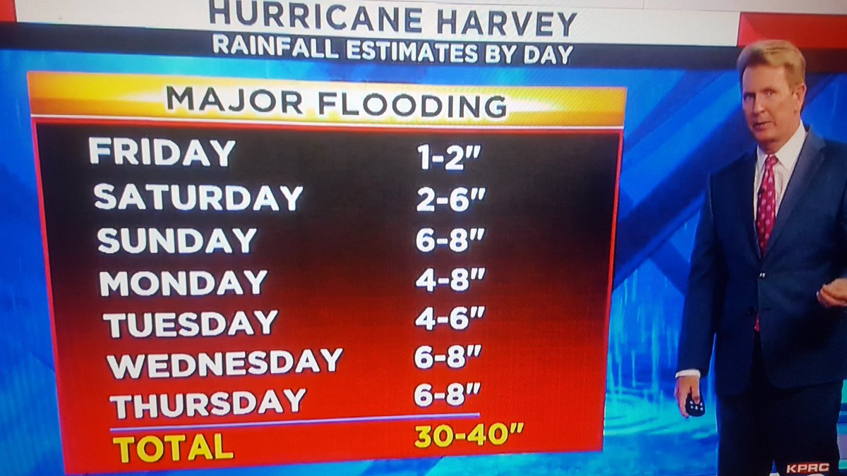
This visual alone...TXWeatherFan wrote:Anyone have a clip of Frank giving that forecast?sau27 wrote:I was watching that. He almost seemed shell shocked while he was presenting the forecast. He's been around for a very long time, did not think I'd ever see that.txsnowmaker wrote:
Yes. "High" chance for most of Harris County is what he tweeted: https://mobile.twitter.com/TillmanWeath ... 7249140736. The time stamp for that is 6 pm Saturday.
Frank Billingsley was a bit concerned to say the least on Ch. 2's 10 pm newscast. While showing the "American" model rain forecast, he said "If you see on Facebook that Frank Billingsley is in tears, this is why..."
Meaning the GFS has Harvey wandering from Corpus, near Houston, to up near Marshall. IF that model holds up, there will be a lot more inland flooding north of Houston than originally anticipated.javakah wrote:What do you mean?DoctorMu wrote:...to nowhere in east Texas, that's for sure.don wrote:The 0z GFS would be truly historical if it panned out
-
MontgomeryCoWx
- Posts: 2357
- Joined: Wed Dec 14, 2011 4:31 pm
- Location: Weimar, TX
- Contact:
This thing is blowing up. It's going to hit Cat 4
Team #NeverSummer
What makes you say that?MontgomeryCoWx wrote:This thing is blowing up. It's going to hit Cat 4
-
MontgomeryCoWx
- Posts: 2357
- Joined: Wed Dec 14, 2011 4:31 pm
- Location: Weimar, TX
- Contact:
Little to no shear, upper 80s bath water and slower movement
Last edited by MontgomeryCoWx on Fri Aug 25, 2017 12:47 am, edited 1 time in total.
Team #NeverSummer
-
MontgomeryCoWx
- Posts: 2357
- Joined: Wed Dec 14, 2011 4:31 pm
- Location: Weimar, TX
- Contact:
Anyone see HWRF dumping 60 inches of rain in Houston. That's more than our YEARLY average.
Team #NeverSummer
Where are you seeing that?MontgomeryCoWx wrote:Anyone see HWRF dumping 60 inches of rain in Houston. That's more than our YEARLY average.
-
- Information
-
Who is online
Users browsing this forum: Ahrefs [Bot], Bing [Bot], DoctorMu, Houstonkid, TexasBreeze, Texashawk, TXWeatherMan and 240 guests