
August 2017: Looking Back at Harvey 5 Year Later
Damn. This is an absolute nightmare scenario for emergency managers.
-
srainhoutx

- Site Admin

- Posts: 19616
- Joined: Tue Feb 02, 2010 2:32 pm
- Location: Maggie Valley, NC
- Contact:
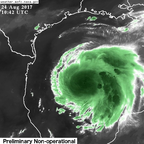
FYI: GOES 16 has Mesoscale Imagery centered over Harvey.
http://weather.cod.edu/satrad/exper/?pa ... o2-13-48-1
http://weather.cod.edu/satrad/exper/?pa ... o2-13-48-1
- Attachments
-
Carla/Alicia/Jerry(In The Eye)/Michelle/Charley/Ivan/Dennis/Katrina/Rita/Wilma/Humberto/Ike/Harvey
Member: National Weather Association
Facebook.com/Weather Infinity
Twitter @WeatherInfinity
Member: National Weather Association
Facebook.com/Weather Infinity
Twitter @WeatherInfinity
-
srainhoutx
- Site Admin
- Posts: 19616
- Joined: Tue Feb 02, 2010 2:32 pm
- Location: Maggie Valley, NC
- Contact:
NOAA G-IV High Altitude mission underway. This data should be in the 12Z suite of guidance...
The G-IV hurricane hunter jet continues to fly around Harvey
August 24, 2017 · by noaahrd
NOAA’s hurricane hunter G-IV jet is gearing up for another flight. The jet will takeoff at 0530 UTC (1:30 AM ET) for a seven-hour flight. It will fly from Lakeland Linder Regional Airport in Lakeland, FL. The G-IV is unique because it can fly at high altitudes and collects data in the surrounding environment. This data is important because it tells us what kind of atmospheric conditions Harvey will encounter as it makes it way over the Gulf of Mexico. The data collected will go into NOAA’s weather prediction model. The flight pattern is shown below. The dots represent the dropwindsonde launch locations.
- Attachments
-
- 08242017 GIV 0530Z untitled.png (56.08 KiB) Viewed 3992 times
Carla/Alicia/Jerry(In The Eye)/Michelle/Charley/Ivan/Dennis/Katrina/Rita/Wilma/Humberto/Ike/Harvey
Member: National Weather Association
Facebook.com/Weather Infinity
Twitter @WeatherInfinity
Member: National Weather Association
Facebook.com/Weather Infinity
Twitter @WeatherInfinity
-
srainhoutx
- Site Admin
- Posts: 19616
- Joined: Tue Feb 02, 2010 2:32 pm
- Location: Maggie Valley, NC
- Contact:
Tropical Storm Harvey Local Statement Advisory Number 15
National Weather Service Houston/Galveston TX AL092017
510 AM CDT Thu Aug 24 2017
This product covers Southeast Texas
**A HURRICANE WARNING HAS BEEN ISSUED FROM PORT MANSFIELD TO MATAGORDA**
**A TROPICAL STORM WARNING HAS BEEN ISSUED FROM MATAGORDA TO HIGH ISLAND**
**A STORM SURGE WARNING HAS BEEN ISSUED FROM PORT MANSFIELD TO SAN LUIS PASS**
**A STORM SURGE WATCH HAS BEEN ISSUED FROM SAN LUIS PASS TO HIGH ISLAND**
NEW INFORMATION
---------------
* CHANGES TO WATCHES AND WARNINGS:
- The Tropical Storm Watch has been upgraded to a Tropical Storm
Warning for Chambers, Fort Bend, Galveston, Harris, Liberty,
and Wharton
- The Storm Surge Watch has been upgraded to a Storm Surge
Warning and the Hurricane Watch has been upgraded to a Tropical
Storm Warning for Brazoria
- The Hurricane Watch has been upgraded to a Hurricane Warning
and the Storm Surge Watch has been upgraded to a Storm Surge
Warning for Jackson and Matagorda
- The Tropical Storm Watch has been cancelled for Austin,
Colorado, and Waller
* CURRENT WATCHES AND WARNINGS:
- A Storm Surge Warning and Tropical Storm Warning are in effect
for Brazoria
- A Storm Surge Warning and Hurricane Warning are in effect for
Jackson and Matagorda
- A Tropical Storm Warning and Storm Surge Watch are in effect
for Chambers, Galveston, and Harris
- A Tropical Storm Warning is in effect for Fort Bend, Liberty,
and Wharton
* STORM INFORMATION:
- About 420 miles south-southeast of Freeport TX
- 23.2N 92.8W
- Storm Intensity 45 mph
- Movement North or 360 degrees at 10 mph
SITUATION OVERVIEW
------------------
Tropical Storm Harvey is gradually strengthening as it moves NW
towards the Texas Coast. Harvey is expected to continue to strengthen
into a hurricane on Friday before landfall. The primary impact from
Harvey remains heavy rainfall and subsequent flooding for southeast
Texas, but there is also the threat for tropical storm to hurricane
force winds and storm surge along the coast. The most likely arrival
time for tropical storm force winds to reach the upper Texas coast is
during the day on Friday.
POTENTIAL IMPACTS
-----------------
* FLOODING RAIN:
Protect against life-threatening rainfall flooding having possible
extensive impacts across Southeast Texas.
Potential impacts include:
- Major rainfall flooding may prompt several evacuations and
rescues.
- Rivers and tributaries may rapidly overflow their banks in
multiple places. Small streams, creeks, canals, and ditches may
become dangerous rivers. Flood control systems and barriers
may become stressed.
- Flood waters can enter many structures within multiple
communities, some structures becoming uninhabitable. Flood waters
may cover escape routes. Streets and parking lots could become
rivers of moving water with underpasses becoming submerged
creating dangerous driving conditions.
* SURGE:
Protect against life-threatening surge having possible extensive
impacts along the coast southwest of San Luis Pass.
Potential impacts in this area include:
- Large areas of deep inundation with storm surge flooding
accentuated by battering waves. Structural damage to buildings,
with some washing away. Damage may be compounded by floating
debris. Locations may become uninhabitable for an extended period
of time.
- Large sections of nearshore escape routes and secondary roads may
become washed out or severely flooded. Flood control systems and
barriers could become stressed.
- Significant beach erosion with dune loss.
- Moderate to locally severe damage to marinas, docks, boardwalks,
and piers. Small craft may break away from moorings, especially
in unprotected anchorages with some lifted onshore and stranded.
Also, protect against locally hazardous surge having possible limited
impacts across Galveston Bay.
* WIND:
Protect against dangerous wind having possible significant impacts across
coastal Jackson and Matagorda Counties.
Potential impacts in this area include:
- Moderate to locally significant damage to roofing and siding
materials, along with damage to porches, awnings, carports, and
sheds. Buildings may experience window, door, and garage door
failures. Severely damaged mobile homes, with some destroyed.
Damage will be accentuated by airborne projectiles.
- Several large trees snapped or uprooted but with greater numbers
in places where trees are shallow rooted. Several fences and
roadway signs blown over.
- Some roads impassable from large debris, and more within urban or
heavily wooded places. A few impassable bridges, causeways, and
access routes.
- Scattered areas with power and communications outages but more prevalent
in areas with above ground lines.
Also, protect against locally hazardous winds having possible limited impacts across
more inland locations within Jackson and Matagorda Counties, as well
as southern Brazoria, Wharton and Fort Bend Counties.
* TORNADOES:
Protect against a tornadoes within the surrounding thunderstorm bands
of Harvey across southeastern Texas.
Potential impacts include:
- The occurrence of isolated tornadoes can hinder the execution
of emergency plans during tropical events.
- A few places may experience tornado damage, along with power
and communications disruptions.
- Locations impacted by isolated tornadoes would experience roofs
peeled off buildings, chimneys toppled, mobile homes pushed off
foundations or overturned, large tree tops and branches snapped
off, shallow rooted trees knocked over, moving vehicles blown off
roads, and small boats pulled from moorings.
PRECAUTIONARY/PREPAREDNESS ACTIONS
----------------------------------
* EVACUATIONS:
For those under evacuation orders, leave as soon as practical with a
destination in mind. Gas up your vehicle well ahead of time. Be sure
that you take all essential materials from your emergency supplies kit.
Let others know where you are going and when you intend to arrive.
If evacuating the area, stick to prescribed evacuation routes. Look
for additional traffic information on roadway smart signs and listen to
select radio channels for further travel instructions. Drivers should
not use cell phones while operating vehicles.
For those not under evacuation orders, understand that there are
inherent risks to evacuation (such as traffic congestion, accidents,
and driving in bad weather), so evacuate only if necessary. Help keep
roadways open for those that are under evacuation orders.
If you are exceptionally vulnerable to wind or water hazards from
tropical systems, consider voluntary evacuation, especially if being
officially recommended. Relocate to a predetermined shelter or safe
destination.
If evacuating away from the area or relocating to a nearby shelter,
leave early before weather conditions become hazardous.
* OTHER PREPAREDNESS INFORMATION:
Now is the time to bring to completion all preparations to protect
life and property in accordance with your emergency plan.
Outside preparations should be wrapped up as soon as possible before
weather conditions completely deteriorate. Any remaining evacuations
and relocations should be expedited before the onset of tropical
storm force wind.
If you are relocating to safe shelter, leave as early as possible. If
heading to a community shelter, become familiar with the shelter
rules before arrival, especially if you have special needs or own a
pet. Take essential items with you from your Emergency Supplies Kit.
Check the latest weather forecast before departing.
Failure to adequately shelter may result in serious injury or loss of
life. Always heed the advice of local officials and comply with any
orders that are issued. Remember, during the storm 9 1 1 Emergency
Services may not be able to immediately respond if conditions are
unsafe. This should be a big factor in your decision making.
Check-in with your emergency points of contact among family, friends,
and workmates. Inform them of your status and well-being. Let them
know how you intend to ride out the storm and when you plan to
check-in again.
Keep cell phones well charged and handy. Also, cell phone chargers
for automobiles can be helpful after the storm. Locate your chargers
and keep them with your cell phone.
If relocating to a nearby shelter or to the home of a family member
or friend, drive with extra caution, especially on secondary roads.
Remember, many bridges and causeways will be closed once higher winds
arrive. Also, if you encounter water covering the road, seek an
alternate route. Always obey official road signs for closures and
detours.
Closely monitor NOAA Weather radio or other local news outlets for
official storm information. Be ready to adapt to possible changes to
the forecast.
* ADDITIONAL SOURCES OF INFORMATION:
- For information on appropriate preparations see ready.gov
- For information on creating an emergency plan see getagameplan.org
- For additional disaster preparedness information see redcross.org
NEXT UPDATE
-----------
The next local statement will be issued by the National Weather
Service in Houston/Galveston TX around 8 AM CDT, or sooner if
conditions warrant.
Carla/Alicia/Jerry(In The Eye)/Michelle/Charley/Ivan/Dennis/Katrina/Rita/Wilma/Humberto/Ike/Harvey
Member: National Weather Association
Facebook.com/Weather Infinity
Twitter @WeatherInfinity
Member: National Weather Association
Facebook.com/Weather Infinity
Twitter @WeatherInfinity
-
srainhoutx
- Site Admin
- Posts: 19616
- Joined: Tue Feb 02, 2010 2:32 pm
- Location: Maggie Valley, NC
- Contact:
For our Neighbors in the NWS Corpus Christi Forecast Area...
Tropical Storm Harvey Local Statement Advisory Number 15
National Weather Service Corpus Christi TX AL092017
451 AM CDT Thu Aug 24 2017
This product covers SOUTH TEXAS
**HARVEY FORECAST TO STRENGTHEN TO A HURRICANE**
NEW INFORMATION
---------------
* CHANGES TO WATCHES AND WARNINGS:
- The Hurricane Watch has been upgraded to a Hurricane Warning
for Bee, Goliad, Jim Wells, Live Oak, and Victoria
- The Hurricane Watch has been upgraded to a Hurricane Warning
and the Storm Surge Watch has been upgraded to a Storm Surge
Warning for Aransas, Calhoun, Kleberg, Nueces, Refugio, and San
Patricio
- A Tropical Storm Warning has been issued for Duval and McMullen
* CURRENT WATCHES AND WARNINGS:
- A Hurricane Warning is in effect for Bee, Goliad, Jim Wells,
Live Oak, and Victoria
- A Storm Surge Warning and Hurricane Warning are in effect for
Aransas, Calhoun, Kleberg, Nueces, Refugio, and San Patricio
- A Tropical Storm Warning is in effect for Duval and McMullen
* STORM INFORMATION:
- About 420 miles southeast of Port Aransas TX or about 420 miles
south-southeast of Port Oconnor TX
- 23.2N 92.8W
- Storm Intensity 45 mph
- Movement North or 360 degrees at 10 mph
SITUATION OVERVIEW
------------------
Tropical Storm Harvey is moving slightly faster to the northwest
over the southern Gulf of Mexico. Harvey is expected to continue
to strengthen as it approaches the Texas coast today into Friday.
Tropical storm force winds could approach coastal areas in the
Coastal Bend as early as late tonight.
Heavy rainfall is expected through much of the area with rainfall
totals of 15 to 20 inches east of I37 with isolated amounts around
25 inches possible. Lesser amounts are expected further west and
southwest. These numbers and locations are subject to change
depending on the exact point of landfall along the Texas coast.
Flash flooding is possible with these high rainfall totals. The
heaviest rains are expected to occur Thursday night through Saturday
night and possibly into early next week.
Peak Storm surge inundation is generally expected to be 5 to 7 feet
above ground level along and to the right of where the center
crosses the coast. Impacts would be felt along the barrier islands
and into the inland bays and waterways. Isolated locations could see
slightly higher inundation.
Tornadoes are possible as rainbands move onshore tonight through Saturday.
POTENTIAL IMPACTS
-----------------
* FLOODING RAIN:
Prepare for dangerous rainfall flooding having possible significant
impacts across the Coastal Bend, especially east of I37. Potential
impacts include:
- Moderate rainfall flooding may prompt several evacuations and
rescues.
- Rivers and tributaries may quickly become swollen with swifter
currents and overspill their banks in a few places, especially
in usually vulnerable spots. Small streams, creeks, canals, and
ditches overflow.
- Flood waters can enter some structures or weaken foundations.
Several places may experience expanded areas of rapid
inundation at underpasses, low-lying spots, and poor drainage
areas. Some streets and parking lots take on moving water as
storm drains and retention ponds overflow. Driving conditions
become hazardous. Some road and bridge closures.
Prepare for locally hazardous rainfall flooding having possible
limited impacts across the Brush Country.
* SURGE:
Prepare for life-threatening surge having possible extensive impacts
across the Middle Texas Coast and barrier islands. Potential impacts
in this area include:
- Large areas of deep inundation with storm surge flooding
accentuated by battering waves. Structural damage to buildings,
with several washing away. Damage compounded by floating
debris. Locations may be uninhabitable for an extended period.
- Large sections of near-shore escape routes and secondary roads
washed out or severely flooded. Flood control systems and
barriers may become stressed.
- Severe beach erosion with significant dune loss.
- Major damage to marinas, docks, boardwalks, and piers. Many
small craft broken away from moorings, especially in
unprotected anchorages with some lifted onshore and stranded.
Elsewhere across SOUTH TEXAS, little to no impact is anticipated.
* WIND:
Prepare for life-threatening wind having possible extensive impacts
across the Coastal Bend. Potential impacts in this area include:
- Considerable roof damage to sturdy buildings, with some having
window, door, and garage door failures leading to structural
damage. Mobile homes severely damaged, with some destroyed.
Damage accentuated by airborne projectiles. Locations may be
uninhabitable for weeks.
- Many large trees snapped or uprooted along with fences and
roadway signs blown over.
- Some roads impassable from large debris, and more within urban
or heavily wooded places. Several bridges, causeways, and
access routes impassable.
- Large areas with power and communications outages.
Also, prepare for dangerous wind having possible significant impacts
across the Brush Country.
* TORNADOES:
Prepare for a tornado event having possible limited impacts across South Texas.
Potential impacts include:
- The occurrence of isolated tornadoes can hinder the execution
of emergency plans during tropical events.
- A few places may experience tornado damage, along with power
and communications disruptions.
- Locations could realize roofs peeled off buildings, chimneys
toppled, mobile homes pushed off foundations or overturned,
large tree tops and branches snapped off, shallow-rooted trees
knocked over, moving vehicles blown off roads, and small boats
pulled from moorings.
PRECAUTIONARY/PREPAREDNESS ACTIONS
----------------------------------
* EVACUATIONS:
If evacuating the area, stick to prescribed evacuation routes.
Look for additional traffic information on roadway smart signs
and listen to select radio channels for further travel
instructions. Drivers should not use cell phones while operating
vehicles.
* OTHER PREPAREDNESS INFORMATION:
Del Mar will be closing at 10 PM CDT this evening.
Padre Island National Seashore will close its beaches to driving at
noon today.
Texas A & M - Corpus Christi has issued a mandatory evacuation for its
campus. All students and residents must vacate the campus by 7 AM CDT today.
Texas A & M - Kingsville will be closing at 5 PM CDT today and will
remain closed through at least Sunday.
Now is the time to check your emergency plan and take necessary
actions to secure your home or business. Deliberate efforts should be
underway to protect life and property. Ensure that your Emergency
Supplies Kit is stocked and ready.
Closely monitor NOAA Weather Radio or other local news outlets for
official storm information. Listen for possible changes to the
forecast.
* ADDITIONAL SOURCES OF INFORMATION:
- For information on appropriate preparations see ready.gov
- For information on creating an emergency plan see getagameplan.org
- For additional disaster preparedness information see redcross.org
NEXT UPDATE
-----------
The next local statement will be issued by the National Weather
Service in Corpus Christi TX around 7 AM CDT, or sooner if conditions
warrant.
Carla/Alicia/Jerry(In The Eye)/Michelle/Charley/Ivan/Dennis/Katrina/Rita/Wilma/Humberto/Ike/Harvey
Member: National Weather Association
Facebook.com/Weather Infinity
Twitter @WeatherInfinity
Member: National Weather Association
Facebook.com/Weather Infinity
Twitter @WeatherInfinity
-
Katdaddy

- Global Moderator

- Posts: 2502
- Joined: Thu Feb 04, 2010 8:18 am
- Location: League City, Tx
- Contact:
Not sure I can add much that already has not been said. Harvey is now a Tropical Storm as the intensification process is ongoing with banding and looking impressive on IR satellite this morning. Harvey will become a hurricane prior to landfall early Saturday morning NE of Corpus Christi. If I lived in the Corpus Christi areas up to Matagorda; I would be taking a PTO and putting up storm panels starting in 30 minutes with the first daylight. Depending on the model trends today, I may be doing this this evening or first thing tomorrow morning. Time to take things serious and the first of 6 very busy weather days ahead.
I have concern Harvey could strengthen more before landfall with the warm waters and slow movement. The GFS model run this morning ramps Harvey up to powerful hurricane with landfall at Corpus Christi.
In addition, prolonged heavy rains are still forecast by the models for S, S Central, SE TX, and SW LA with 10-20” rains and possibly higher totals.

Anyone think the models / track will shift northward any? A graphic I saw showed harvey coming back into the gulf and riding up the coast. Just concerned about the catching us off guard scenario. Either way my preps are beginning today!
Last edited by djmike on Thu Aug 24, 2017 6:02 am, edited 1 time in total.
Mike
Beaumont, TX
(IH-10 & College Street)
Beaumont, TX
(IH-10 & College Street)
6z hwrf has a decent shift up the coast into Matagorda Bay.
-
srainhoutx
- Site Admin
- Posts: 19616
- Joined: Tue Feb 02, 2010 2:32 pm
- Location: Maggie Valley, NC
- Contact:
06Z Hurricane Models landfall:
HWRF = Western Matagorda Bay = Major
HMON = Padre Island = CAT 2, close to CAT 3 but sheared
HWRF = Western Matagorda Bay = Major
HMON = Padre Island = CAT 2, close to CAT 3 but sheared
Carla/Alicia/Jerry(In The Eye)/Michelle/Charley/Ivan/Dennis/Katrina/Rita/Wilma/Humberto/Ike/Harvey
Member: National Weather Association
Facebook.com/Weather Infinity
Twitter @WeatherInfinity
Member: National Weather Association
Facebook.com/Weather Infinity
Twitter @WeatherInfinity
Scott747 wrote:6z hwrf has a decent shift up the coast into Matagorda Bay.
Man you guys are quick,i was just getting ready to post on that.
-
TexasBreeze
- Posts: 943
- Joined: Sun Sep 26, 2010 4:46 pm
- Location: NW Houston, TX
- Contact:
Still 12in + in the gfs 6z for the southern half of the area.
-
srainhoutx
- Site Admin
- Posts: 19616
- Joined: Tue Feb 02, 2010 2:32 pm
- Location: Maggie Valley, NC
- Contact:
For our Neighbors and many KHOU Weather Forum friends/supporters in The Rio Grande Valley...
Tropical Storm Harvey Local Statement Advisory Number 15
National Weather Service Brownsville TX AL092017
619 AM CDT Thu Aug 24 2017
This product covers The Rio Grande Valley and Deep South Texas
**Tropical Storm Harvey Gaining Strength, Moving Faster**
NEW INFORMATION
---------------
* CHANGES TO WATCHES AND WARNINGS:
- A Tropical Storm Warning has been issued for Brooks, Inland
Cameron, and Inland Willacy
- The Tropical Storm Watch has been upgraded to a Hurricane Watch
and the Tropical Storm Watch has been upgraded to a Tropical
Storm Warning and a Storm Surge Watch have been issued for
Coastal Cameron and Coastal Willacy
- The Hurricane Watch has been upgraded to a Hurricane Warning
and the Storm Surge Watch has been upgraded to a Storm Surge
Warning for Kenedy
* CURRENT WATCHES AND WARNINGS:
- A Tropical Storm Warning is in effect for Brooks, Inland
Cameron, and Inland Willacy
- A Tropical Storm Warning, Storm Surge Watch, and Hurricane
Watch are in effect for Coastal Cameron and Coastal Willacy
- A Storm Surge Warning and Hurricane Warning are in effect for
Kenedy
* STORM INFORMATION:
- About 350 miles east-southeast of Brownsville TX or about 370
miles southeast of Port Mansfield TX
- 23.2N 92.8W
- Storm Intensity 45 mph
- Movement North or 360 degrees at 10 mph
SITUATION OVERVIEW
------------------
Tropical Storm Harvey has strengthen overnight and continues to show
steady organization this morning. NOAA and Air Force Hurricane Hunter
aircraft have been investigating the storm all night and found a
larger wind field, steadily fall central pressure and detected a faster
forward motion. Due to the increase in forward speed and forecast for
continued intensification today through Friday Hurricane and Tropical
Warnings have been issued.
The faster motion and larger wind field could result in Tropical Storm
force winds approaching coastal waters and portions of the Lower Texas
coast as early as late this evening and overnight with some small
probability of portions of the Lower Rio Grande Valley seeing some
Tropical Storm wind gusts after midnight Friday morning. The more
likely time for tropical storm force winds will be during the day
Friday.
A voluntary evacuation declaration for high profile and recreational
vehicles has been issued for residents and visitors at South Padre
Island. Also county beach access 3 to 6 and Boca Chica beach are
closed until further notice.
Heavy rainfall is expected in the path of Harvey Tonight and Friday
and once Harvey moves inland Friday night and Saturday. A Flash Flood
Watch has been issued for Brooks and Kenedy counties where 3 to 5
inches with locally higher amounts exceeding 6 inches are expected.
Elsewhere, 2 to 4 inches with local higher amounts of 5 inches. The
Flash Flood watch could be expanded into portions of the Rio Grande
Valley if the track of Harvey varies slightly to the west.
Storm surge inundation of up to 7 feet is possible across Padre Island
and along the Laguna Madre in Kenedy county. 2 to 4 feet is possible
along the South Padre and Boca Chica beach as well as along the Willacy
county coast.
POTENTIAL IMPACTS
-----------------
* FLOODING RAIN:
Prepare for dangerous rainfall flooding having possible significant
impacts across Brooks and Kenedy counties as well as portions of the
Mid and Lower Rio Grande Valley
. Potential impacts include:
- Moderate rainfall flooding may prompt several evacuations and
rescues.
- Rivers and tributaries may quickly become swollen with swifter
currents and overspill their banks in a few places, especially
in usually vulnerable spots. Small streams, creeks, canals,
arroyos, and ditches overflow.
- Flood waters can enter some structures or weaken foundations.
Several places may experience expanded areas of rapid
inundation at underpasses, low-lying spots, and poor drainage
areas. Some streets and parking lots take on moving water as
storm drains and retention ponds overflow. Driving conditions
become hazardous. Some road and bridge closures.
Prepare for locally hazardous rainfall flooding having possible
limited impacts across the Upper Rio Grande Valley and the Western
Ranchlands.
* WIND:
Prepare for against life-threatening wind having possible extensive
impacts across Coastal areas of Deep South Texas and the Barrier Island
. Potential impacts in this area include:
- Considerable roof damage to sturdy buildings, with some having
window, door, and garage door failures leading to structural
damage. Mobile homes severely damaged, with some destroyed.
Damage accentuated by airborne projectiles. Locations may be
uninhabitable for weeks.
- Many large trees snapped or uprooted along with fences and
roadway signs blown over.
- Some roads impassable from large debris, and more within urban
or heavily wooded places. Several bridges, causeways, and
access routes impassable.
- Large areas with power and communications outages.
Also, protect against dangerous wind having possible limited to
significant impacts across the mid and lower Rio Grande Valley.
* SURGE:
Protect against life-threatening surge having possible extensive
impacts across Kenedy county and along the Barrier Island.
. Potential impacts in this area include:
- Large areas of deep inundation with storm surge flooding
accentuated by battering waves. Structural damage to buildings,
with several washing away. Damage compounded by floating
debris. Locations may be uninhabitable for an extended period.
- Large sections of near-shore escape routes and secondary roads
washed out or severely flooded. Flood control systems and
barriers may become stressed.
- Severe beach erosion with significant dune loss.
- Major damage to marinas, docks, boardwalks, and piers. Many
small craft broken away from moorings, especially in
unprotected anchorages with some lifted onshore and stranded.
Also, protect against life-threatening surge having possible
significant impacts across South Padre Island and Boca Chica Beaches as
well as the Barrier Island north of South Padre Island and south of
Port Mansfield.
Also, protect against locally hazardous surge having possible limited
impacts across portions of the Laguna Madre near South Padre Island.
Elsewhere across The Rio Grande Valley and Deep South Texas, little
to no impact is anticipated.
* TORNADOES:
Prepare for a tornado event having possible limited impacts across
portions of Kenedy county. Potential impacts include:
- The occurrence of isolated tornadoes can hinder the execution
of emergency plans during tropical events.
- A few places may experience tornado damage, along with power
and communications disruptions.
- Locations could realize roofs peeled off buildings, chimneys
toppled, mobile homes pushed off foundations or overturned,
large tree tops and branches snapped off, shallow-rooted trees
knocked over, moving vehicles blown off roads, and small boats
pulled from moorings.
Elsewhere across The Rio Grande Valley and Deep South Texas, little
to no impact is anticipated at this time.
PRECAUTIONARY/PREPAREDNESS ACTIONS
----------------------------------
* EVACUATIONS:
If evacuating the area, stick to prescribed evacuation routes. Look
for additional traffic information on roadway smart signs and listen to
select radio channels for further travel instructions. Drivers should
not use cell phones while operating vehicles.
If you are exceptionally vulnerable to wind or water hazards from
tropical systems, consider voluntary evacuation, especially if being
officially recommended. Relocate to a predetermined shelter or safe
destination.
If evacuating away from the area or relocating to a nearby shelter,
leave early before weather conditions become hazardous.
* OTHER PREPAREDNESS INFORMATION:
Now is the time to bring to completion all preparations to protect
life and property in accordance with your emergency plan.
If you live in a place that is particularly vulnerable to high wind,
such as a mobile home, an upper floor of a high rise building, or on
a boat, plan to move to safe shelter. Take enough supplies for you
and your family for several days.
Always heed the advice of local officials and comply with any orders
that are issued. Do not needlessly jeopardize your life or the lives
of others.
Check-in with your emergency points of contact among family, friends,
and workmates. Inform them of your status and well-being. Let them
know how you intend to ride out the storm and when you plan to
check-in again.
Keep cell phones well charged and handy. Also, cell phone chargers
for automobiles can be helpful after the storm. Locate your chargers
and keep them with your cell phone.
In emergencies it is best to remain calm. Stay informed and focused
on the situation at hand. Exercise patience with those you encounter.
Be a Good Samaritan and helpful to others.
If you are a visitor and still in the area, listen for the name of the
city or town in which you are staying within local news updates. Be
sure you know the name of the county in which it resides. Pay
attention for instructions from local authorities.
Closely monitor NOAA Weather radio or other local news outlets for
official storm information. Be ready to adapt to possible changes to
the forecast.
* ADDITIONAL SOURCES OF INFORMATION:
- For information on appropriate preparations see ready.gov
- For information on creating an emergency plan see getagameplan.org
- For additional disaster preparedness information see redcross.org
NEXT UPDATE
-----------
The next local statement will be issued by the National Weather
Service in Brownsville TX around 11am CDT, or sooner if conditions
warrant.
Carla/Alicia/Jerry(In The Eye)/Michelle/Charley/Ivan/Dennis/Katrina/Rita/Wilma/Humberto/Ike/Harvey
Member: National Weather Association
Facebook.com/Weather Infinity
Twitter @WeatherInfinity
Member: National Weather Association
Facebook.com/Weather Infinity
Twitter @WeatherInfinity
Hell of a difference in appearance from last night.
 Pressures already dropped to 985Mb which puts it in Cat 1 range already.
Pressures already dropped to 985Mb which puts it in Cat 1 range already.Are we still looking at Friday evening the rain and wind starting for us here in SE Texas? Trying not to be stuck at work when this starts - want to be at home.
-
srainhoutx
- Site Admin
- Posts: 19616
- Joined: Tue Feb 02, 2010 2:32 pm
- Location: Maggie Valley, NC
- Contact:
We in Coastal SE TX could start feeling the effects of the outer bands late tonight. Check back for updates as the day wears on.ticka1 wrote:Are we still looking at Friday evening the rain and wind starting for us here in SE Texas? Trying not to be stuck at work when this starts - want to be at home.
Carla/Alicia/Jerry(In The Eye)/Michelle/Charley/Ivan/Dennis/Katrina/Rita/Wilma/Humberto/Ike/Harvey
Member: National Weather Association
Facebook.com/Weather Infinity
Twitter @WeatherInfinity
Member: National Weather Association
Facebook.com/Weather Infinity
Twitter @WeatherInfinity
-
srainhoutx
- Site Admin
- Posts: 19616
- Joined: Tue Feb 02, 2010 2:32 pm
- Location: Maggie Valley, NC
- Contact:
Pressures continue to fall on the current USAF RECON mission first center pass. Pressure down to 985.3mb
Carla/Alicia/Jerry(In The Eye)/Michelle/Charley/Ivan/Dennis/Katrina/Rita/Wilma/Humberto/Ike/Harvey
Member: National Weather Association
Facebook.com/Weather Infinity
Twitter @WeatherInfinity
Member: National Weather Association
Facebook.com/Weather Infinity
Twitter @WeatherInfinity
http://www.nhc.noaa.gov/#Harvey
WTNT34 KNHC 241146
TCPAT4
BULLETIN
Tropical Storm Harvey Intermediate Advisory Number 15A
NWS National Hurricane Center Miami FL AL092017
700 AM CDT Thu Aug 24 2017
...AIR FORCE HURRICANE HUNTER PLANE FINDS HARVEY STRENGTHENING...
SUMMARY OF 700 AM CDT...1200 UTC...INFORMATION
----------------------------------------------
LOCATION...23.8N 93.0W
ABOUT 380 MI...615 KM SE OF PORT OCONNOR TEXAS
ABOUT 335 MI...540 KM SE OF PORT MANSFIELD TEXAS
MAXIMUM SUSTAINED WINDS...60 MPH...95 KM/H
PRESENT MOVEMENT...NNW OR 345 DEGREES AT 10 MPH...17 KM/H
MINIMUM CENTRAL PRESSURE...986 MB...29.12 INCHES
WATCHES AND WARNINGS
--------------------
CHANGES WITH THIS ADVISORY:
None.
SUMMARY OF WATCHES AND WARNINGS IN EFFECT:
A Storm Surge Warning is in effect for...
* Port Mansfield to San Luis Pass Texas
A Storm Surge Watch is in effect for...
* South of Port Mansfield Texas to the Mouth of the Rio Grande
* North of San Luis Pass to High Island Texas
A Hurricane Warning is in effect for...
* Port Mansfield to Matagorda Texas
A Tropical Storm Warning is in effect for...
* North of Matagorda to High Island Texas
* South of Port Mansfield Texas to the Mouth of the Rio Grande
A Hurricane Watch is in effect for...
* South of Port Mansfield Texas to the Mouth of the Rio Grande
A Tropical Storm Watch is effect for...
* South of the Mouth of the Rio Grande to Boca de Catan Mexico
A Storm Surge Warning means there is a danger of life-threatening
inundation, from rising water moving inland from the coastline,
during the next 36 hours in the indicated locations. For a
depiction of areas at risk, please see the National Weather
Service Storm Surge Watch/Warning Graphic, available at
hurricanes.gov. This is a life-threatening situation. Persons
located within these areas should take all necessary actions to
protect life and property from rising water and the potential for
other dangerous conditions. Promptly follow evacuation and other
instructions from local officials.
A Hurricane Warning means that hurricane conditions are expected
somewhere within the warning area. A warning is typically issued
36 hours before the anticipated first occurrence of tropical-storm-
force winds, conditions that make outside preparations difficult or
dangerous. Preparations to protect life and property should be
rushed to completion.
A Tropical Storm Warning means that tropical storm conditions are
expected somewhere within the warning area within 36 hours.
A Storm Surge Watch means there is a possibility of life-
threatening inundation, from rising water moving inland from the
coastline, in the indicated locations during the next 48 hours.
A Hurricane Watch means that hurricane conditions are possible
within the watch area.
A Tropical Storm Watch means that tropical storm conditions are
possible within the watch area.
In addition, interests in southwestern Louisiana should continue to
monitor the progress of this system.
For storm information specific to your area in the United
States, including possible inland watches and warnings, please
monitor products issued by your local National Weather Service
forecast office. For storm information specific to your area outside
the United States, please monitor products issued by your national
meteorological service.
DISCUSSION AND 48-HOUR OUTLOOK
------------------------------
At 700 AM CDT (1200 UTC), the center of Tropical Storm Harvey was
located by a reconnaissance plane near latitude 23.8 North,
longitude 93.0 West. Harvey is moving toward the north-northwest
near 10 mph (17 km/h). A track toward the northwest or
north-northwest at a faster forward speed is expected for the next
48 hours. On the forecast track, Harvey will approach the southern
Texas coast on Friday.
An Air Force Reserve aircraft reports that the maximum sustained
winds have increased to near 60 mph (95 km/h) with higher gusts.
Additional strengthening is forecast during the next 48 hours, and
Harvey is expected to become a hurricane by Friday.
Tropical-storm-force winds extend outward up to 115 miles (185 km)
from the center.
The minimum central pressure based on data from the Air Force
Hurricane Hunter aircraft is 986 mb (29.12 inches).
HAZARDS AFFECTING LAND
----------------------
RAINFALL: Harvey is expected to produce total rain accumulations of
10 to 15 inches with isolated maximum amounts of 25 inches over the
Texas coast through next Wednesday. During the same time period
Harvey is expected to produce total rain accumulations of 3 to 9
inches along its outer radius including parts of south, central, and
eastern Texas and the lower Mississippi Valley. Rainfall from Harvey
may cause life-threatening flooding.
STORM SURGE: The combination of a dangerous storm surge and the
tide will cause normally dry areas near the coast to be flooded by
rising waters moving inland from the shoreline. The water is
expected to reach the following heights above ground if the peak
surge occurs at the time of high tide...
Port Mansfield to San Luis Pass...5 to 7 ft
San Luis Pass to High Island...2 to 4 ft
Mouth of the Rio Grande to Port Mansfield...2 to 4 ft
The deepest water will occur along the immediate coast near and to
the northeast of the landfall location, where the surge will be
accompanied by large and destructive waves. Surge-related flooding
depends on the relative timing of the surge and the tidal cycle, and
can vary greatly over short distances. For information specific to
your area, please see products issued by your local National Weather
Service forecast office.
WIND: Hurricane conditions are likely within the hurricane warning
area late Friday or Friday night, with tropical storm conditions
expected to first reach the coast in the hurricane warning area
Friday.
SURF: Swells generated by Harvey are likely to affect the Texas,
Louisiana, and northeast Mexico coasts by Friday. These swells are
likely to cause life-threatening surf and rip current conditions.
Please consult products from your local weather office.
NEXT ADVISORY
-------------
Next complete advisory at 1000 AM CDT.
$$
Forecaster Berg
It's only the first fix of the mission but harvey is still tracking more to the north.
Need another fix to confirm.
Need another fix to confirm.
Anyone think the track will shift northward any per the latest runs?
Mike
Beaumont, TX
(IH-10 & College Street)
Beaumont, TX
(IH-10 & College Street)
-
TexasBreeze
- Posts: 943
- Joined: Sun Sep 26, 2010 4:46 pm
- Location: NW Houston, TX
- Contact:
That storm looks quite large!! The new storm surge products will be put to the test unfortunately.