Re: June 2017: Typical Summertime WX To End Month
Posted: Thu Jun 29, 2017 7:46 am
000
FXUS64 KHGX 290946
AFDHGX
Area Forecast Discussion
National Weather Service Houston/Galveston TX
446 AM CDT Thu Jun 29 2017
.DISCUSSION...
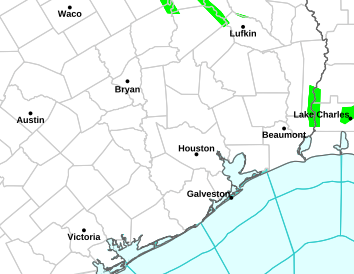
Periods of showers and thunderstorms will likely continue along
the coast and over the Gulf waters for much of the morning.
Isolated pockets of heavy rain are possible this morning,
especially if these storms continue to train over the same areas.
Isolated to scattered showers and storms will be possible this
afternoon further inland, but the greatest potential will likely
be generally south of the Hwy 59 corridor. Right now, there is a
pretty tight PW gradient across the CWA, with values close to 2.0"
right at the coast and offshore tapering off to around 1.3" in
the College Station area. With southwest flow in place, this PW
gradient will likely remain in place for today and severely limit
PoP chances across the Brazos Valley. Scattered showers and storms
are forecast again on Friday, with the greatest chances over the
eastern portion of the area as an upper-level weakness pushes
further off to the east.
Ridging noses in beginning on Friday night and takes hold of the
forecast through the rest of the forecast period, leaving us with
very summer-like conditions through next week. Temperatures will
warm into the mid 90s during the afternoons, with heat indices
pushing into the mid 100s. Make sure any holiday plans include
plenty of water and a place to cool off.
11
&&
.MARINE...
Storms ongoing across the coastal waters this morning along the
remains of the boundary with it slowly drifting north into SETX.
Southwesterly along the boundary and moderate southerly flow to the
south of it should warrant SCEC conditions through at least late
morning. Expect storm coverage to diminish this morning with a lull
over the waters this afternoon with redevelopment (less so than with
ongoing coverage) this evening. The persistent southerly flow
becomes dominant as upper ridging builds over the western US and
pressures fall over the Plains. Periods of SCEC winds possible
through Saturday. Tide levels still elevated and don`t see much in
the way of improvement until Friday and that may only be slightly.
Will continue the Beach Hazard Statement for strong rip currents and
elevate tide levels through this afternoon but will likely need
extending.
45
&&
.AVIATION...
Not quite as messy as last night...main issue is possibly some
MVFR/IFR ceilings possible for an hour or two near sunrise across
the northern terminals but across the south is the threat of showers
and isolated thunderstorms. Gusty winds of 15 to 20 mph with storms
near the coast should gradually expand north and may reach HOU
before weakening. Scattered SHRA/TSRA possible for HOU southward
this morning then decreasing coverage this afternoon and VCSH will
likely the norm for HOU southward. Patchy MVFR ceilings after 06z
Friday for IAH/HOU northward. Quieter weather expected Friday
afternoon thanks to increased upper ridging influence.
45
&&
.PRELIMINARY POINT TEMPS/POPS...
College Station (CLL) 93 77 94 77 96 / 10 10 20 10 10
Houston (IAH) 91 78 93 78 94 / 30 10 30 10 10
Galveston (GLS) 87 82 89 81 88 / 50 10 20 10 10
&&
.HGX WATCHES/WARNINGS/ADVISORIES...
TX...NONE.
GM...SMALL CRAFT SHOULD EXERCISE CAUTION through this afternoon for
the following zones: Coastal waters from Freeport to the
Matagorda Ship Channel out 20 NM...Coastal waters from High
Island to Freeport out 20 NM...Waters from Freeport to the
Matagorda Ship Channel from 20 to 60 NM...Waters from High
Island to Freeport from 20 to 60 NM.
&&
$$
Discussion...11
Aviation/Marine...45
FXUS64 KHGX 290946
AFDHGX
Area Forecast Discussion
National Weather Service Houston/Galveston TX
446 AM CDT Thu Jun 29 2017
.DISCUSSION...
Periods of showers and thunderstorms will likely continue along
the coast and over the Gulf waters for much of the morning.
Isolated pockets of heavy rain are possible this morning,
especially if these storms continue to train over the same areas.
Isolated to scattered showers and storms will be possible this
afternoon further inland, but the greatest potential will likely
be generally south of the Hwy 59 corridor. Right now, there is a
pretty tight PW gradient across the CWA, with values close to 2.0"
right at the coast and offshore tapering off to around 1.3" in
the College Station area. With southwest flow in place, this PW
gradient will likely remain in place for today and severely limit
PoP chances across the Brazos Valley. Scattered showers and storms
are forecast again on Friday, with the greatest chances over the
eastern portion of the area as an upper-level weakness pushes
further off to the east.
Ridging noses in beginning on Friday night and takes hold of the
forecast through the rest of the forecast period, leaving us with
very summer-like conditions through next week. Temperatures will
warm into the mid 90s during the afternoons, with heat indices
pushing into the mid 100s. Make sure any holiday plans include
plenty of water and a place to cool off.
11
&&
.MARINE...
Storms ongoing across the coastal waters this morning along the
remains of the boundary with it slowly drifting north into SETX.
Southwesterly along the boundary and moderate southerly flow to the
south of it should warrant SCEC conditions through at least late
morning. Expect storm coverage to diminish this morning with a lull
over the waters this afternoon with redevelopment (less so than with
ongoing coverage) this evening. The persistent southerly flow
becomes dominant as upper ridging builds over the western US and
pressures fall over the Plains. Periods of SCEC winds possible
through Saturday. Tide levels still elevated and don`t see much in
the way of improvement until Friday and that may only be slightly.
Will continue the Beach Hazard Statement for strong rip currents and
elevate tide levels through this afternoon but will likely need
extending.
45
&&
.AVIATION...
Not quite as messy as last night...main issue is possibly some
MVFR/IFR ceilings possible for an hour or two near sunrise across
the northern terminals but across the south is the threat of showers
and isolated thunderstorms. Gusty winds of 15 to 20 mph with storms
near the coast should gradually expand north and may reach HOU
before weakening. Scattered SHRA/TSRA possible for HOU southward
this morning then decreasing coverage this afternoon and VCSH will
likely the norm for HOU southward. Patchy MVFR ceilings after 06z
Friday for IAH/HOU northward. Quieter weather expected Friday
afternoon thanks to increased upper ridging influence.
45
&&
.PRELIMINARY POINT TEMPS/POPS...
College Station (CLL) 93 77 94 77 96 / 10 10 20 10 10
Houston (IAH) 91 78 93 78 94 / 30 10 30 10 10
Galveston (GLS) 87 82 89 81 88 / 50 10 20 10 10
&&
.HGX WATCHES/WARNINGS/ADVISORIES...
TX...NONE.
GM...SMALL CRAFT SHOULD EXERCISE CAUTION through this afternoon for
the following zones: Coastal waters from Freeport to the
Matagorda Ship Channel out 20 NM...Coastal waters from High
Island to Freeport out 20 NM...Waters from Freeport to the
Matagorda Ship Channel from 20 to 60 NM...Waters from High
Island to Freeport from 20 to 60 NM.
&&
$$
Discussion...11
Aviation/Marine...45