
June 2017: Typical Summertime WX To End Month

12z Euro is weaker with the system it shows it as a very broad area of low pressure, that stays a open wave or depression the interesting thing is that regardless it still brings the system to Texas/Mexico and still brings heavy rains into Southeast Texas next Thursday - Saturday with rainfall amounts of 4-8 inches across Southeast Texas fwiw.
-
srainhoutx

- Site Admin

- Posts: 19616
- Joined: Tue Feb 02, 2010 2:32 pm
- Location: Maggie Valley, NC
- Contact:
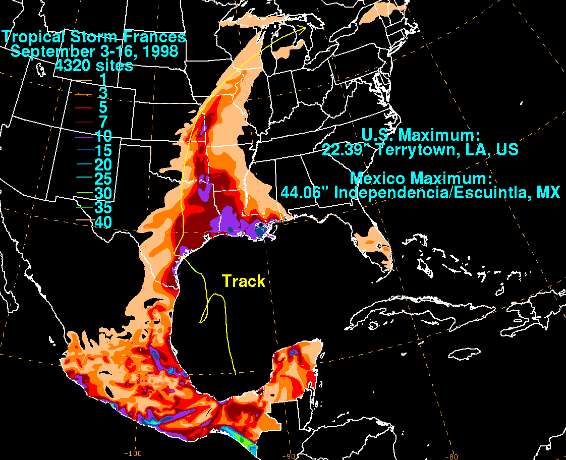
It appears that the tropical wave about to enter the Eastern Caribbean is the disturbance that the models are attempting to develop sometime Sunday or Monday the NW Caribbean near the Yucatan Peninsula. Although Frances 1998 may not be a prefect analog, it does appear there are some potential similarities. Frances was very erratic and did have at least a couple of vortices that stretched across the Western Gulf and brought torrential rainfall across Texas and Louisiana as well as Mexico.

Carla/Alicia/Jerry(In The Eye)/Michelle/Charley/Ivan/Dennis/Katrina/Rita/Wilma/Humberto/Ike/Harvey
Member: National Weather Association
Facebook.com/Weather Infinity
Twitter @WeatherInfinity
Member: National Weather Association
Facebook.com/Weather Infinity
Twitter @WeatherInfinity

869MB wrote:I think it's really funny and ironic you say that because I was just thinking the exact same thing after I read what they had to say. My vibe is they may get away with it regarding this particular system, but they may want to be more careful going forward in regards to their verbiage and attitude with respect to possible future tropical systems this year because one of these disturbances may pull a surprise and their discussions may come back to haunt them.Portastorm wrote:I mean no disrespect or throwing "shade" on HGX but I don't understand how they can continue to be so dismissive of the possibility of this potential system impacting South and Southeast Texas. Caution and patience are certainly the guidance key words here so that folks don't freak out about one model run. But that being said, there is a litany of tropical systems impacting this region in the month of June. It's not like it's unheard of.
With the GFS and Euro suffering beyond Day 5 in the skill scores, I'd be really concerned about any possibility beyond that range.
They are *probably* correct, but agreed this verbiage is a near taunting of mother nature...
Guidance has been suggesting the possibility of a broad sfc low
developing near the Yucatan or Bay of Campeche about that time as
well. It`s always worth keeping an eye on the evolution of these
things, but until if/when something becomes better defined, wouldn`t
put a lot of stock on any particular model solution. They`ll
likely continue change run-to-run... 47
Euro has featured that NW drift of a wave/low for a couple of days now. Something to monitor.don wrote:12z Euro is weaker with the system it shows it as a very broad area of low pressure, that stays a open wave or depression the interesting thing is that regardless it still brings the system to Texas/Mexico and still brings heavy rains into Southeast Texas next Thursday - Saturday with rainfall amounts of 4-8 inches across Southeast Texas fwiw.


Tropical Storm Francis in 1998 was quite a rainmaker. It caused a lot of beach erosion despite being a tropical storm. It was a very large tropical storm.srainhoutx wrote:It appears that the tropical wave about to enter the Eastern Caribbean is the disturbance that the models are attempting to develop sometime Sunday or Monday the NW Caribbean near the Yucatan Peninsula. Although Frances 1998 may not be a prefect analog, it does appear there are some potential similarities. Frances was very erratic and did have at least a couple of vortices that stretched across the Western Gulf and brought torrential rainfall across Texas and Louisiana as well as Mexico.
http://www.ssd.noaa.gov/goes/east/watl/avn-animated.gif
Yes it was - I remember seeing much of the Gulf covered in her feeder clouds.Ptarmigan wrote:Tropical Storm Francis in 1998 was quite a rainmaker. It caused a lot of beach erosion despite being a tropical storm. It was a very large tropical storm.srainhoutx wrote:It appears that the tropical wave about to enter the Eastern Caribbean is the disturbance that the models are attempting to develop sometime Sunday or Monday the NW Caribbean near the Yucatan Peninsula. Although Frances 1998 may not be a prefect analog, it does appear there are some potential similarities. Frances was very erratic and did have at least a couple of vortices that stretched across the Western Gulf and brought torrential rainfall across Texas and Louisiana as well as Mexico.
http://www.ssd.noaa.gov/goes/east/watl/avn-animated.gif
Massive rainfall:
-
srainhoutx
- Site Admin
- Posts: 19616
- Joined: Tue Feb 02, 2010 2:32 pm
- Location: Maggie Valley, NC
- Contact:
It looks like the monsoonal gyre is starting in earnest this morning over/near Guatemala/Honduras and the SW/Western Caribbean. The NHC has increased chances for Tropical Development to 50% which to me suggests we are about 24 hours or so from an INVEST being declared and the Hurricane Models being initiated for this potential tropical disturbance. Also of note, the Experimental Ensemble TC Genesis Probabilities have steadily increased to near 80% to 90% in the NW Caribbean Sea/Yucatan Peninsula. A new Advisory Feature this year that will be tested is Watches/Warnings being initiated before any actual Tropical Cyclone develops, possibly as much as 48 hours prior to any actual TC development and making a potential landfall or where Tropical Storm Force winds can be expected.. It is more likely that the NHC may wait until 24 to 36 hours ahead of actual Development, more likely Sunday or Monday. This morning the Frances 1998 analog appears to be the most likely outcome with a broad low level circulation with imbedded multiple smaller vortices rotating around the broad surface low pressure. Interest from Mexico, Texas and Louisiana should closely monitor further updates. The Weather Prediction Center indicated in their early morning Extended Outlook that Texas may see significant rainfall during their conference call with the NHC. Stay Tuned and Stay Weather aware through the weekend into early next week!

Tropical Weather Outlook
NWS National Hurricane Center Miami FL
800 AM EDT Thu Jun 15 2017
For the North Atlantic...Caribbean Sea and the Gulf of Mexico:
1. A tropical wave located several hundred miles south-southwest of
the Cabo Verde Islands is producing disorganized showers and
thunderstorms. Some gradual development of this system is possible
during the next few days while the wave moves westward near 20 mph
over the tropical Atlantic.
* Formation chance through 48 hours...low...10 percent.
* Formation chance through 5 days...low...20 percent.
2. A complex area of low pressure is expected to form over the
northwestern Caribbean Sea and the Yucatan peninsula this
weekend. Conditions appear to be favorable for gradual development
of this system while it moves slowly northwestward toward the
southern Gulf of Mexico by early next week.
* Formation chance through 48 hours...low...near 0 percent.
* Formation chance through 5 days...medium...50 percent.
Forecaster Cangialosi
Carla/Alicia/Jerry(In The Eye)/Michelle/Charley/Ivan/Dennis/Katrina/Rita/Wilma/Humberto/Ike/Harvey
Member: National Weather Association
Facebook.com/Weather Infinity
Twitter @WeatherInfinity
Member: National Weather Association
Facebook.com/Weather Infinity
Twitter @WeatherInfinity
-
srainhoutx
- Site Admin
- Posts: 19616
- Joined: Tue Feb 02, 2010 2:32 pm
- Location: Maggie Valley, NC
- Contact:
Thursday morning briefing from Jeff:
NHC has increased the potential for tropical cyclone formation around the Yucatan over the next 5 days to 50%.
Tropical system possible in the Gulf of Mexico late this weekend/early next week
A complicated pattern will evolve across the western Caribbean Sea and southern Gulf of Mexico this weekend which may give rise to the formation of a tropical storm in the Gulf of Mexico by late this weekend or early next week. A tropical wave currently moving through the Caribbean Sea will arrive into the western Caribbean Sea early this weekend while a northward lifting trough off the coast of Panama will interact with this wave. Convection has been increasing over much of the western Caribbean Sea over the last 24 hours and expect a continued increase in thunderstorm develop as these two features interact.
Model agreement from the ECWMF, GFS, CMC, UKMET, and many of the ensemble members show the formation of a very large surface low around the Yucatan over the weekend. While it is certainly possible for such a large surface low to develop into a tropical system, they tend to be very slow in doing so due to the massive size. What tends to be more common is that vorticity centers will rotate around the average low position and can sometimes become the dominate circulation center which can cause a plethora of forecast issues. Overall the organization of such a system takes longer than normal and can remain a disorganized mess. Several Gulf systems have developed this way and the main important feature from a system like this is to spread out the impacts over a wide area.
While the land interaction of the Yucatan will play some role in how this system develops and likely when, the overall model consensus and large size of the system should be able to overcome the interaction with the Yucatan. There is certainly enough support to have some confidence that a tropical depression or tropical storm will be forming in the south/south-central Gulf of Mexico by late this weekend.
The track of any developing tropical system will hinge on the ridge axis across the SW US and how far east that ridge axis may extend into TX. Additionally, the position of the mid and upper level ridge across the southern plains and where/how strong a weakness in this ridge over the W/NW Gulf by early next week. Models have been trending toward a ridge axis further to the north than previously expected along with the formation of an upper level weakness over the western Gulf of Mexico. This would likely help to bring any S/SC Gulf tropical system toward the WNW/NW into the western or northwestern Gulf of Mexico. It should be noted that some of the model guidance brings a stronger system more quickly northward toward the central and eastern US Gulf coast caught in the tail end of a trough over the Great Lakes. This solution appears less likely given the fact that the developing system will likely be disorganized and not as strong as those models are forecasting.
Most confident solution at this time is to bring a tropical depression/tropical storm away from the NW coast of the Yucatan Sun/Mon on a WNW motion and into the SC Gulf of MX Tues/Wed and then into the W Gulf of MX by the end of next week. A large mass of potential tropical storm force winds may cover much of the central Gulf of Mexico by the middle of next week.
Points of Interest:
o Actual formation of the surface center may be key to track…but may not be as important as with other systems…given the very large size
o Large size of the system will have far reaching impacts
o Land interaction will complicate development over the weekend
o Track is still uncertain
Possible TX Impacts:
It is too early to be certain of any impacts along the TX coast given the uncertainty in the track forecast and what shape the system gradually develops into. Following the WNW track coordinated by NHC and WPC overnight into the western Gulf of Mexico middle to late next week would bring some degree of impacts toward the TX coast.
o Seas will likely begin to respond as early as Tuesday especially if the large mass of TS force winds forms across the northern semi-circle of the system
o As seas increase so may tides as more water is brought toward the coast in larger swells. Additionally winds will back to a more ESE/E direction across the northern Gulf which is a favorable tidal increase direction for the TX coast
o At some point could see a significant increase in moisture into TX if the center reaches the western Gulf allowing deep ESE flow through the column to transport copious moisture toward the coast.
Impacts, if any, will continue to be defined and clarified over the coming days.
Residents along the Gulf coast should closely monitor the progress of this system. Now is the time to make sure hurricane preparation plans and kits are fully stocked and in place.
- Attachments
-
Carla/Alicia/Jerry(In The Eye)/Michelle/Charley/Ivan/Dennis/Katrina/Rita/Wilma/Humberto/Ike/Harvey
Member: National Weather Association
Facebook.com/Weather Infinity
Twitter @WeatherInfinity
Member: National Weather Association
Facebook.com/Weather Infinity
Twitter @WeatherInfinity

Very Interesting.
Of course I will be out of town next week, but I can make it back.
Of course I will be out of town next week, but I can make it back.
-
tireman4

- Global Moderator

- Posts: 4493
- Joined: Wed Feb 03, 2010 9:24 pm
- Location: Humble, Texas
- Contact:
From HGX this morning...
TROPICAL...
There`s not much to be said at this point about the tropics that
astute watchers of the weather don`t already know (as the readers
of this AFD likely are). There is a pretty decent looking wave in
the eastern Atlantic and another about to exit Africa, but it`s
probably a little early for main development region activity.
Regardless, tons of time to monitor anything that far east.
Our Yucatan region has gotten a bump up to 40% for development in
the next 5 days from NHC. There`s certainly some potential here,
and we`ve given it the focus of this section in previous days. But
the expectation continues to be for any low pressure center to be
week, and stay confined to the southern Gulf with no direct
impact to our area. As yesterday`s 00Z Euro showed, there may be
avenues for that to change, but is also a caution against putting
much/any stock in individual runs of deterministic models at this
range. Something to watch, a good reminder to complete those
seasonal preparations, not something to stress over at this point.
tireman4 wrote:From HGX this morning...
TROPICAL...
There`s not much to be said at this point about the tropics that
astute watchers of the weather don`t already know (as the readers
of this AFD likely are). There is a pretty decent looking wave in
the eastern Atlantic and another about to exit Africa, but it`s
probably a little early for main development region activity.
Regardless, tons of time to monitor anything that far east.
Our Yucatan region has gotten a bump up to 40% for development in
the next 5 days from NHC. There`s certainly some potential here,
and we`ve given it the focus of this section in previous days. But
the expectation continues to be for any low pressure center to be
week, and stay confined to the southern Gulf with no direct
impact to our area. As yesterday`s 00Z Euro showed, there may be
avenues for that to change, but is also a caution against putting
much/any stock in individual runs of deterministic models at this
range. Something to watch, a good reminder to complete those
seasonal preparations, not something to stress over at this point.
Sounds like they are really downplaying any chances of this affecting Texas...
They are cozying up to the Euro. 
Even though the Euro has the system making landfall in Mexico most of the moisture is displaced well off to the north across Southeast Texas and Louisiana, it shows very heavy rainfall across the area fwiw.
-
TexasBreeze
- Posts: 943
- Joined: Sun Sep 26, 2010 4:46 pm
- Location: NW Houston, TX
- Contact:
Euro holds ground into NE Mx and GFS goes to east Gulf. The 2 model camps make it a difficult forecast, but the west Gulf solution looks more plausible at this point.
There would be quite a bit of rain on the mid and SE Texas coast with this solution.TexasBreeze wrote:Euro holds ground into NE Mx and GFS goes to east Gulf. The 2 model camps make it a difficult forecast, but the west Gulf solution looks more plausible at this point.

-
TexasBreeze
- Posts: 943
- Joined: Sun Sep 26, 2010 4:46 pm
- Location: NW Houston, TX
- Contact:
Yes there would be considering the large size of the progged system!
when do you think they will name it an invest?
-
wxman57

- Global Moderator
- Posts: 2621
- Joined: Thu Feb 04, 2010 5:34 am
- Location: Southwest Houston (Westbury)
- Contact:
Looks like the 18Z GFS gave up on the Florida hit. It shifted west with a weaker system heading for northern Mexico, though it has it very weak by then. I still like the Euro best. Was in touch with AFMET today (S2K Forum). He is able to view the private military model that did very well with Hermine & Matthew last year. It's in line with the Euro in the westward track into Mexico. I think there's about an 80-90% chance we will have TS Bret by Monday PM, Tuesday AM at the latest and Monday AM at the earliest. Most likely track west into NE Mexico next Thursday.
This would mean very heavy rain moving into the lower to mid TX coast next Thu/Fri. We'll probably escape the heaviest rain this far north.
This would mean very heavy rain moving into the lower to mid TX coast next Thu/Fri. We'll probably escape the heaviest rain this far north.
It needs to park somewhere where we can catch up on rain. My yard is already trying to die again.
-
- Information
-
Who is online
Users browsing this forum: Ahrefs [Bot], Cpv17, DoctorMu, TexasBreeze and 57 guests