
June 2017: Typical Summertime WX To End Month
-
Katdaddy

- Global Moderator

- Posts: 2502
- Joined: Thu Feb 04, 2010 8:18 am
- Location: League City, Tx
- Contact:
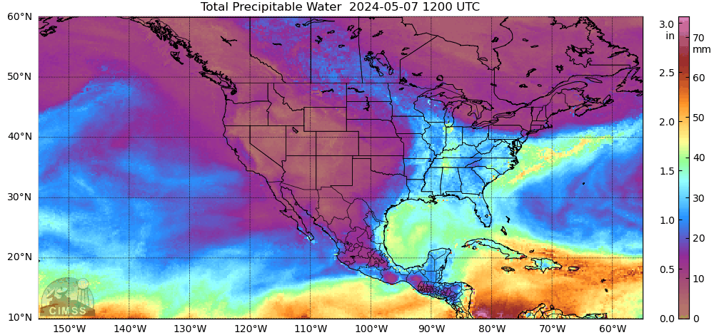
A few scattered showers off the Upper TX Coast this morning. Additional isolated tropical showers and thunderstorms today and Saturday with the potential of more widespread rains Sunday and Monday. This morning’s satellite shows a stream of deep tropical moisture across MX and the GOM as well as a storm complex over SW TX.
- Attachments
-
- Screen Shot 2017-06-02 at 5.44.44 AM.png (222.43 KiB) Viewed 4947 times
-
srainhoutx

- Site Admin

- Posts: 19616
- Joined: Tue Feb 02, 2010 2:32 pm
- Location: Maggie Valley, NC
- Contact:
Friday morning briefing from Jeff:
Heavy rainfall ongoing across SW TX this morning as the next upper level trough approaches the state.
Moisture remains plentiful over the region today with trigger temperatures in the lower 80’s so expect to see showers and thunderstorms develop late morning into the afternoon hours as the seabreeze moves inland. Similar setup on Saturday with scattered pockets of thunderstorms and heavy rainfall.
Forecast becomes significantly more complicated Sunday-Tuesday as a slow moving upper level trough tries to cut off over TX. Deep tropical moisture (some from the tropical storm which made landfall over southern Mexico yesterday) will be brought northward into the TX coast late Sunday and especially on Monday. PWS surge to near 2.2 inches by Monday and this combined with the upper trough overhead is cause for concern with respect to heavy rainfall. CIPS analogs and hinting at the upper trough trying to become warm core as it sits in this tropical environment and this is certainly possible given a deep saturated level and very high PWS values along with generally weak winds aloft. Such systems in the past have produce excessive nocturnal core rains near their circulation centers as they begin to behave like a decaying tropical system. Position of this upper level feature would support excessive rainfall over SW/SC TX Sunday and then across SE TX late Sunday-Tuesday. Storm motions also drop off to less than 10kts during this period which is also concerning. Positive factor is that there does not appear to be any low level boundary in place to focus thunderstorms, but outflow boundaries and even the seabreeze this time of year can be the needed boundary to anchor and sustain convection.
Tropics:
Moisture plume from landfalling MX tropical storm is spread out across the entire Gulf of Mexico and aimed mainly at the central and eastern Gulf coast. Approach of the southern stream trough this weekend will help to redirect some of this moisture back NW toward the TX coast. Mid level vort center associated with the landfalling system still looks to moving into the Bay of Campeche at some point this weekend. Model solutions have generally backed away from any sort of surface low forming in the western Gulf, but this remains an area to at least keep an eye on through early next week.
Carla/Alicia/Jerry(In The Eye)/Michelle/Charley/Ivan/Dennis/Katrina/Rita/Wilma/Humberto/Ike/Harvey
Member: National Weather Association
Facebook.com/Weather Infinity
Twitter @WeatherInfinity
Member: National Weather Association
Facebook.com/Weather Infinity
Twitter @WeatherInfinity
-
tireman4

- Global Moderator
- Posts: 4488
- Joined: Wed Feb 03, 2010 9:24 pm
- Location: Humble, Texas
- Contact:
000
FXUS64 KHGX 021747
AFDHGX
Area Forecast Discussion
National Weather Service Houston/Galveston TX
1247 PM CDT Fri Jun 2 2017
.AVIATION...
Radar so far today looking a lot like yesterday. Convection along
the seabreeze continuing to move inland...with reports of locally
heavy rains and some funnel clouds. Will keep the mention of TSRA
in for central sites until 22Z (or so). Also going with MVFR CIGS
for the overnight/early Sat morning hours...but would not be that
surprised to see them go lower as they were last night/early this
morning. As for tomorrow, we will likely see a repeat of the SHRA
starting at the coast in the morning, and then slowly working its
way inland through the afternoon. 41
&&
.PREV DISCUSSION... /ISSUED 404 AM CDT Fri Jun 2 2017/
At 300 AM, sfc high pressure was located over the mid Mississippi
Valley with low pressure over eastern Colorado. Light onshore
winds persist under generally clear skies. This has allowed some
patchy fog to develop and have added morning fog to the wx grids.
Showers continue to increase over the Gulf this morning and a few
of these showers should make it to the coast around sunrise. Fcst
soundings show convective temps in the lower 80`s today and PW
values around 1.75 inches. Daytime heating should serve as a
catalyst for scattered showers and thunderstorms today. Storm
motion looks to be on the slow side and slow moving storms will
have the potential to produce locally heavy rain but widespread
heavy rain is not expected.
Some lingering showers will be possible into the evening but skies
are expected to clear by 03z and patchy fog will again be possible
especially areas to the southwest of Houston. Conditions on
Saturday look similar to today with scattered showers and
thunderstorms developing as temperatures warm into the middle 80s.
Rain chances will increase Sunday and Monday as an upper level
trough nears the region. Heights will fall and lift on the east
side of the upper low should give the region a good chance of
precipitation both days. Jet dynamics not looking terrific but
with PW values approaching 1.90 inches on Sunday and 2.10 inches
on Monday and convective temps in the lower 80`s, feel rain
chances will be high both days. Storm motion will be around 5
knots both days so locally heavy rain will remain a threat. The
ECMWF is a little more robust with the upper level system and this
feature is a bit worrisome as some fairly heavy nocturnal June
rain events have developed very close to the upper level low. CIPS
analog guidance shows several precip maximums near SE TX with
several of these between 2 and 4 inches of rain.
The upper trough axis lingers across SE TX on Tuesday but PW
values begin to drop and convective temps begin to warm. Both the
GFS and ECMWF are generous with QPF on Tuesday but signals in the
models would support drier conditions. PW values continue to dry
Wed-Fri and in the wake of a weak cold front that will cross the
area on Tuesday. Low temperatures will trend cooler over the
second half of next week but the drier air will heat efficiently
and afternoon highs should still warm to near 90 degrees each
afternoon. 43
&&
.PRELIMINARY POINT TEMPS/POPS...
College Station (CLL) 88 71 89 72 87 / 30 20 30 30 60
Houston (IAH) 88 74 89 74 87 / 50 20 30 20 60
Galveston (GLS) 85 79 87 80 86 / 30 20 30 20 50
&&
.HGX WATCHES/WARNINGS/ADVISORIES...
TX...NONE.
GM...NONE.
&&
$$
-
srainhoutx
- Site Admin
- Posts: 19616
- Joined: Tue Feb 02, 2010 2:32 pm
- Location: Maggie Valley, NC
- Contact:
Lots of tropical rainstorms around the Region and reports of several tropical funnels have been received. These storms are capable of dropping a quick inch or two wherever than move through. Copious deep and rich tropical moisture is surging toward the Texas Coast and PW's look to increase to above 2.2 inches which let's us know how deep and moist this tropical moisture is. It is also noteworthy that virtually all of the 12Z Global guidance suggest a wave of low pressure will advance North out of the Bay of Campeche ahead od a potent upper air disturbance on Sunday and Monday. The 1007mb low looks to move to near or just SW of Corpus as the shortwave exits Mexico into S Central Texas. Looks like an unsettled period may be ahead.

I will also note that the Ensembles suggest an Upper Ridge builds across the Northern Plains and Mid West with lowering pressures across the Gulf Of Mexico and a potential Easterly Wave cross the Gulf from East to West beneath that building Upper Ridge well to our North.
I will also note that the Ensembles suggest an Upper Ridge builds across the Northern Plains and Mid West with lowering pressures across the Gulf Of Mexico and a potential Easterly Wave cross the Gulf from East to West beneath that building Upper Ridge well to our North.
Carla/Alicia/Jerry(In The Eye)/Michelle/Charley/Ivan/Dennis/Katrina/Rita/Wilma/Humberto/Ike/Harvey
Member: National Weather Association
Facebook.com/Weather Infinity
Twitter @WeatherInfinity
Member: National Weather Association
Facebook.com/Weather Infinity
Twitter @WeatherInfinity
might mow the grass a little shorter ?
MIMIC TPW2 72 hrs: http://tropic.ssec.wisc.edu/real-time/m ... anim=html5
last 24 hrs
MIMIC TPW2 72 hrs: http://tropic.ssec.wisc.edu/real-time/m ... anim=html5
last 24 hrs
^^ That looks perrrttyyy.. Hope it gets here though. Everything I see shows most of the rain going to the East of Texas due to the Jet.

I think today will be a busy day. Convective temps are low and cells are already popping in this tropical airmass. I'm watching the outflow boundary to our north, along with activity out west.
-
srainhoutx
- Site Admin
- Posts: 19616
- Joined: Tue Feb 02, 2010 2:32 pm
- Location: Maggie Valley, NC
- Contact:
The current surface analysis suggest that a weak, highly sheared surface low has developed in the Bay of Campeche East of Veracruz and North of Tabasco. A trough extends N in the Western Gulf and along the Middle and Upper Texas Coast.
Sorry I cannot make the Hurricane Expo today, but I encourage those that have never attended to head down to the GRB and meet our NWS, Harris County Flood Control and other folks that are huge fans of our KHOU Weather Forum.
Sorry I cannot make the Hurricane Expo today, but I encourage those that have never attended to head down to the GRB and meet our NWS, Harris County Flood Control and other folks that are huge fans of our KHOU Weather Forum.
- Attachments
-
Carla/Alicia/Jerry(In The Eye)/Michelle/Charley/Ivan/Dennis/Katrina/Rita/Wilma/Humberto/Ike/Harvey
Member: National Weather Association
Facebook.com/Weather Infinity
Twitter @WeatherInfinity
Member: National Weather Association
Facebook.com/Weather Infinity
Twitter @WeatherInfinity

Interesting.
I would assume most of this weather would be pushed off to the East?
I would assume most of this weather would be pushed off to the East?
Did get a mention.

Are we done with the sea breeze storms today?
Got a good one here earlier, but radar seems pretty quiet, even with all the Gulf moisture out there.
Got a good one here earlier, but radar seems pretty quiet, even with all the Gulf moisture out there.

Rip76 wrote:Are we done with the sea breeze storms today?
Got a good one here earlier, but radar seems pretty quiet, even with all the Gulf moisture out there.
Mostly in the NW HGX region. Teasing College Station at the moment.

Praise the Lord and pass the ammunition? Surge of Tropical moisture on the way.
Won the jackpot! Scored 1.4 in of rain in 20 min IMBY. As heavy a downpour I've seen in CLL in a decade - sheets of rain lashing the yard...
...or driving through a cloudburst in Florida
...or driving through a cloudburst in Florida
Evening briefing from Jeff.
An upper level trough will bring widespread rains…some heavy to SE TX over the next 48 hours.
An upper level trough over NW TX will slowly drop SE toward SE TX while moisture surges inland from the Gulf of Mexico. Have seen several thunderstorms develop late this afternoon over the region along numerous outflow boundaries. Thus far storms have been very outflow dominant and not able to sustain themselves for much longer than 30 min to about an hour which has kept short duration rainfall totals under control. Short term guidance is not in good agreement on where or when additional storms will develop. Think the loss of heating will lead to a gradual decline in storms by mid evening, but surge of moisture arriving at the coast around 300am combined with any disturbances approaching from the W/SW could result in the formation of storms between 300-600am Sunday morning. Runs of the HRRR and TX TECH WRF model suggest this potential but do not really agree on a location. Appears this activity may fire along a surface trough along US 59, but that is highly questionable.
Depending on what happens early Sunday will likely dictate development later in the morning on into Sunday afternoon. Global models show widespread development once trigger temperatures in the lower 80’s are achieved, but meso models are not as aggressive likely because they develop more early morning activity which would tend to stabilize the air mass some….but not completely.
With high moisture levels remaining in place, slowing storm motions (10kts or less), general large scale lift, and a nearly saturated air column all point toward a heavy rainfall threat. Good news thus far continues to be the lack of any sustained surface trough or boundary which could anchor or stall convection greatly increasing the flash flood threat. Current thinking is that storms will continue to be outflow dominated with a quick 1-2 inches of rainfall in the stronger cells. Some of the meso models are pegging a couple 3-5 inch bullseyes over the region Sunday and Monday which suggest some sort of slow moving convection, but without any defined surface boundary in place (not saying one wont form at some point) think the threat for significant flash flooding is low. Main threat will be street flooding from intense short term rainfall rates.
Will continue with high rain chances Sunday night-Tuesday with the upper trough overhead shifting slowly toward the NW Gulf. Some sort of sustained boundary could form during this period over the region along with fairly favorable venting of the upper levels…so the heavy rainfall threat will be maintained.
Trough moves into the Gulf by Wednesday with a rare June cool front crossing the area. Dewpoints may fall into the 50’s by Thursday which is very rare for June.
Tropics:
Remains of eastern Pacific tropical storm are currently located over the Bay of Campeche where surface pressures have fallen to 1007mb. Surface circulation is evident on visible images, but strong WSW upper level winds are preventing convection from developing near this circulation. Not expecting any development from this feature.
Overall pattern across the Gulf will remain unsettle into middle June with surges of tropical moisture out of the Caribbean Sea and some interaction with troughs across the northern Gulf. Will need to continue to watch the Gulf into middle June.
Area Forecast Discussion
National Weather Service Houston/Galveston TX
712 PM CDT Sat Jun 3 2017
.AVIATION...
A few short term concerns. Scattered storms in Harris Co should be
in the vicinity of IAH for the next hour or two. Lightning, wind
gusts ~25kt and brief heavy rain the primary concern there.
Looking further north where a line of showers and embedded tstms
are situated from roughly Crockett to Brenham will be pivoting ese
thru the evening - likely making it thru UTS, CXO, and possibly
IAH between now and 11pm or so. Same type of impacts - brief heavy
rain limiting visby to 0.75-1.5nm, wind gusts ~30kt and lightning.
There are numerous boundaries running around, so brief collisions
will enhance overall strength at times.
Think we`ll probably see things start tapering off toward
midnight. After the precip, confidence as to whether cigs will
fill in and fall is low, so will keep prevailing at MVFR or higher
until trends are established. By mid/late morning Sunday, we
should see precip redeveloping and expand in areal coverage and
persist thru much of the day. Probably could have gone
categorical -ra vcts working after about 17z and will consider
that for the 6z package. Wide range on conditions expected, VFR
outside of convection, to IFR under the strongest cells. 47
&&
.PREV DISCUSSION... /ISSUED 339 PM CDT Sat Jun 3 2017/
Showers and thunderstorms ongoing this afternoon mainly along the
seabreeze now east of I-45 and starting to develop along the
Highway 59 corridor southwest of Richmond. Active storms over West
and North-Central Texas this afternoon in association with the
slow moving upper low near KFDR. Storms in SETX should continue to
expand inland and likely increase a little in coverage and
intensity with atmosphere becoming more unstable across the
northern CWA. Brief heavy downpours still possible this
afternoon/early evening.
Guidance is all over the place for tonight/Sunday. Storms that are
going on across TX not lining up well with most of the higher res
modeling and hence confidence is lower on how this plays out
overnight. Thinking the general trend should be southeastward as
the upper low detaches and drifts towards SETX. Complex of storms
rolling down the Rio Grande will also add more uncertainty to the
forecast as some of this mass could shift eastward. WV/Vis imagery
showing the deeper moisture over the Gulf moving toward SETX/LA
and the leading edge of the deeper moisture should reach the
coastal areas by 03z. This should set the stage for slow moving
heavy rain as remnants of storms to the west die off during the
convective minimum and then leave a boundary to potentially help
focus storms along in the morning. Convective temperatures Sunday
82-83 which will be easily reachable. PW spiking up to 2-2.2"
should increase rainfall efficiency. Thinking the coverage will be
fairly widespread with pockets of heavy rains of 2 to 4 inches.
May lead to some isolated street flooding.
Upper low continues to track southeastward and should move through
the area Tuesday with a `cold front`. This should further
destabilize the airmass and lead to continued threat of slow
moving showers and thunderstorms Monday night/Tuesday. Eventually
Wednesday SETX gets on the back side of the upper low and coverage
should diminish with warming mid levels and drying in the lower
levels of the atmosphere thanks to weak high pressure building
into the area in the wake of the `June front`.
Thursday through Saturday looking pleasant for June with low pops
and heat index readings of 85-95. 45
mice little downpour here, nothing severe http://atmo.tamu.edu/ciams/lma/network_loop.html
https://twitter.com/iembot_hgx
Special Weather Statement
National Weather Service Houston/Galveston TX
840 PM CDT SAT JUN 3 2017
TXZ164-177>179-198-199-212-213-040245-
San Jacinto TX-Walker TX-Grimes TX-Waller TX-Polk TX-Harris TX-
Montgomery TX-Trinity TX-
840 PM CDT SAT JUN 3 2017
...Line of strong thunderstorms impacting the region through 930
PM CDT...
At 838 PM CDT, Doppler radar was tracking strong thunderstorms along
a line extending from 8 miles northwest of Montgomery to near Prairie
View. Movement was northeast at approximately 30 mph.
Half inch hail and winds in excess of 30 mph will be possible with
these storms.
Locations impacted include...
Huntsville, Willis, Prairie View, Pinehurst, Magnolia, New Waverly,
Pine Island, Point Blank, Montgomery, Riverside, Todd Mission,
Huntsville State Park, Lake Conroe Dam, Crabbs Prairie, Dobbin,
Oakhurst and Dacus.
PRECAUTIONARY/PREPAREDNESS ACTIONS...
Torrential rainfall is also occurring with these storms, and may lead
to localized flooding. Do not drive your vehicle through flooded
roadways.
Frequent cloud to ground lightning is occurring with these storms.
Lightning can strike 10 miles away from a thunderstorm. Seek a safe
shelter inside a building or vehicle.
These storms may intensify, so be certain to monitor local radio
stations and available television stations for additional information
and possible warnings from the National Weather Service.
Special Weather Statement
National Weather Service Houston/Galveston TX
114 AM CDT SUN JUN 4 2017
TXZ195>198-040645-
Brazos TX-Washington TX-Grimes TX-Burleson TX-
114 AM CDT SUN JUN 4 2017
...SIGNIFICANT WEATHER ADVISORY FOR SOUTHEASTERN BURLESON...NORTHERN
GRIMES...NORTHEASTERN WASHINGTON AND BRAZOS COUNTIES UNTIL 145 AM
CDT...
At 113 AM CDT, Doppler radar was tracking a strong thunderstorm 9
miles southwest of Millican, or 14 miles west of Navasota, moving
northeast at 35 mph.
Winds in excess of 40 mph will be possible with this storm.
Locations impacted include...
College Station, Bryan, Navasota, Washington, Somerville, Snook,
Kurten, Wixon Valley, Millican, Lake Somerville Dam, Kyle Field,
Independence, Wellborn, Roans Prairie and Carlos.
PRECAUTIONARY/PREPAREDNESS ACTIONS...
Torrential rainfall is also occurring with this storm, and may lead
to localized flooding. Do not drive your vehicle through flooded
roadways.
Frequent cloud to ground lightning is occurring with this storm.
Lightning can strike 10 miles away from a thunderstorm. Seek a safe
shelter inside a building or vehicle.
If on or near Lake Somerville, get out of the water and move indoors
or inside a vehicle. Remember, lightning can strike out to 10 miles
from the parent thunderstorm. If you can hear thunder, you are close
enough to be struck by lightning. Move to safe shelter now! Do not
be caught on the water in a thunderstorm.
&&
LAT...LON 3074 9647 3087 9639 3065 9588 3021 9624
3032 9656
TIME...MOT...LOC 0613Z 209DEG 28KT 3038 9633
-
Katdaddy
- Global Moderator
- Posts: 2502
- Joined: Thu Feb 04, 2010 8:18 am
- Location: League City, Tx
- Contact:
Flash Flood Warnings continue for Galveston and Chambers Counties as well as the Beaumont and Port Arthur areas as the heavy rains drift slowly offshore.
- Attachments
-
- Screen Shot 2017-06-04 at 11.41.36 AM.png (13.43 KiB) Viewed 4559 times
-
- Screen Shot 2017-06-04 at 11.42.20 AM.png (99.36 KiB) Viewed 4559 times

Over 5" and higher here in Bmt. Many roads closed due to flooding. Heaviest rains now moving east and offshore but another system to affect us later tonight/overnight and Monday and Tuesday. Hadnt had a drop of rain in 36 days but today it sure made up for it. Light rain now. Lighting and thunder were intense. Now just a constant rolling thunder. Nice for a relax and due nothing Sunday. Might take me a nap.
Mike
Beaumont, TX
(IH-10 & College Street)
Beaumont, TX
(IH-10 & College Street)

djmike wrote:Over 5" and higher here in Bmt. Many roads closed due to flooding. Heaviest rains now moving east and offshore but another system to affect us later tonight/overnight and Monday and Tuesday. Hadnt had a drop of rain in 36 days but today it sure made up for it. Light rain now. Lighting and thunder were intense. Now just a constant rolling thunder. Nice for a relax and due nothing Sunday. Might take me a nap.
Gotta love Texas. Feast or famine in the precipitation department.
Anyways attention shifts to our west as more develops for the afternoon and evening hours.
~~~When Thunder Roars Go Indoors~~~
~~~Turn Around Don't Drown~~~
~~~Run From The Water, Hide From The Wind~~~
~~~Turn Around Don't Drown~~~
~~~Run From The Water, Hide From The Wind~~~
-
- Information
-
Who is online
Users browsing this forum: Ahrefs [Bot], Bing [Bot], tireman4 and 61 guests