
I shutter to mention anything with how bad the GFS has been recently and it's the very long range. But since it's that time of year and a need for a early heads up for everyone to start dusting off the cobwebs.....
The GFS has been hinting at a possible Gulf system later next week. It's born from slop so who knows where it originates, but the trend on modeling has been enough towards the WGOM too at least keep a tiny eye on things even if it's the likely phantom system.
June 2017: Typical Summertime WX To End Month
-
srainhoutx

- Site Admin

- Posts: 19616
- Joined: Tue Feb 02, 2010 2:32 pm
- Location: Maggie Valley, NC
- Contact:
As Scott mentioned, we are seeing signs that the monsoonal trough with several broad spurious low pressure systems attempt to organize out of the monsoonal trough slop as it lifts North from. Central America. Typically these disturbances are slow to develop, if they do and can be prolific rain makers.
I am seeing a couple of other synoptic features that suggest conditions for potential tropical development have some credibility. A rather stout Convective Coupled Kelvin Wave as well as a favorable MJO pulse may allow for rising air allowing for tropical thunderstorms to organize as well as lowering mean sea level pressures across the NW Caribbean and the Western Gulf. The latest GEFS ensemble members as well as the ECMWF suggest we may need to turn our eyes South toward the NW Caribbean, Yucatan Peninsula and the Western Gulf later next week for any potential Tropical Troubles that may spin up.
I am seeing a couple of other synoptic features that suggest conditions for potential tropical development have some credibility. A rather stout Convective Coupled Kelvin Wave as well as a favorable MJO pulse may allow for rising air allowing for tropical thunderstorms to organize as well as lowering mean sea level pressures across the NW Caribbean and the Western Gulf. The latest GEFS ensemble members as well as the ECMWF suggest we may need to turn our eyes South toward the NW Caribbean, Yucatan Peninsula and the Western Gulf later next week for any potential Tropical Troubles that may spin up.
- Attachments
-
-
Carla/Alicia/Jerry(In The Eye)/Michelle/Charley/Ivan/Dennis/Katrina/Rita/Wilma/Humberto/Ike/Harvey
Member: National Weather Association
Facebook.com/Weather Infinity
Twitter @WeatherInfinity
Member: National Weather Association
Facebook.com/Weather Infinity
Twitter @WeatherInfinity
-
srainhoutx
- Site Admin
- Posts: 19616
- Joined: Tue Feb 02, 2010 2:32 pm
- Location: Maggie Valley, NC
- Contact:
Friday morning briefing from Jeff:
NW flow aloft this morning with a thunderstorms complex approaching from N TX.
Radar showing leading edge of isolated to scattered thunderstorms associated with a decaying thunderstorm complex over NC TX nearing our NW counties. General air mass over SE TX appears stable, but with heating today and approach of vortex associated with the N TX complex would not rule out an isolated thunderstorm.
Vortex actually grows into an upper level low over SE TX on Saturday which will begin another wet period for the area…although shorter in duration than the last one. Moisture will still be lacking on Saturday, so not expecting much coverage of thunderstorms. Additionally the position of the upper level low is overhead or just east of SE TX which is usually the subsident side of the system. Upper ridge over the Midwest into the NE US early next week will begin to push or retrograde the upper level low or shear axis westward across SE TX Sunday-Tuesday. Position of this feature will allow moisture to return from the Gulf of Mexico with PWS rising to near 2.0 inches by late Sunday. Expect scattered showers and thunderstorms on Sunday along the seabreeze and more widespread activity on Monday.
Upper level shear axis will progress into SW TX by next Tuesday, but moisture will linger and expect activity along the seabreeze likely each day next week. Upper ridge appears to never really gain a good hold over the region and this may become important later next week into the 3rd week of June.
Tropics:
Focus continues to be in the longer range period from roughly the 18th of June onward with now several global forecast models including the GFS, ECMWF, CMC, NOGAPS, and many of their ensemble members developing a large monsoon circulation over the western Caribbean Sea/central America after the 19th. It will be important where this feature actually forms, if at all, as to what chances of development it may have. One important factor that continues to show up in the 500mb height fields is a general weakness over the NC Gulf of Mexico and trough axis across the Great Lakes into the Ohio Valley. As mentioned above upper level ridging never really builds across the US Gulf coast over the next 2 weeks which may leave the door open for any possible tropical development to migrate northward. In fact the latest ensemble clustering has shifted northward away from central America and into the SE/S Gulf of Mexico over the last few runs with a general average position of a very large low pressure system somewhere near/N of the Yucatan between the 18th and 23rd of June. This is all still way out in model la la land…but the increasing consistency is something to watch.
Carla/Alicia/Jerry(In The Eye)/Michelle/Charley/Ivan/Dennis/Katrina/Rita/Wilma/Humberto/Ike/Harvey
Member: National Weather Association
Facebook.com/Weather Infinity
Twitter @WeatherInfinity
Member: National Weather Association
Facebook.com/Weather Infinity
Twitter @WeatherInfinity

Something to keep an eye on down by the Yuc?
-
tireman4

- Global Moderator

- Posts: 4488
- Joined: Wed Feb 03, 2010 9:24 pm
- Location: Humble, Texas
- Contact:
448
FXUS64 KHGX 091451
AFDHGX
Area Forecast Discussion
National Weather Service Houston/Galveston TX
951 AM CDT Fri Jun 9 2017
.DISCUSSION...
Current forecast package looks good, and do not anticipate any significant
changes on the morning update. We`ll be watching the weakening/dissipating
activity off to our north and northwest that continues to edge this
way, and we have low rain chances across parts of our northern counties
in case some of the storms survive. Other than that, the increasing
clouds from this activity could keep afternoon high temperatures a
degree or two lower than expected. 42
&&
.PREV DISCUSSION... /ISSUED 618 AM CDT Fri Jun 9 2017/
AVIATION...
VFR conditions and light winds throughout the forecast period.
Satellite and obs show some mid to high cloud decks working
across the area this morning, but ceilings should stay VFR.
PREV DISCUSSION... /ISSUED 402 AM CDT Fri Jun 9 2017/
DISCUSSION...
GOES 16 IR is showing some impressive cold cloud top temperatures
in SW Oklahoma with ongoing convection. This convection and most
likely resulting vorticity maximum should track within northwest
jet stream flow into north Texas today. Short range models hint at
the possibility of this convection skirting northern areas of the
forecast area from maybe College Station to Crockett early in the
afternoon before dissipating. The HRRR and Texas Tech WRF are most
robust with holding convection together into the Brazos Valley
while the WRF ARW/NMM scatter shoot convection with no real
organization. Low level moisture will be highest over central
Texas so thought would be for convection to develop within this
axis west of the area and if it does move more to the southeast,
then convection will likely dissipate given decreasing instability
and increasing capping. Forecast will go with some 20 PoPs for the
northern tier of counties in SE Texas but little confidence in the
forecast since moisture/instability will be an issue.
The aforementioned vorticity maximum does move into SE TExas by
Saturday morning with a developing upper level low over the area
for Saturday. Deep moisture will just begin to increase so think
rain chances will be on the increase Sunday into Monday. Sunday
the upper low will still be over the NW Gulf and will likely begin
to shear out over the Gulf. The shear axis this moves towards the
northern Gulf Monday into Tuesday. Rain chances look respectable
for scattered showers and storms mainly Monday into Tuesday.
Precipitable water values begin to increase Sunday but do not
reach the 1.8 to 1.9 inch range until Monday. Higher moisture
lingers through Tuesday. Forecast will go with mainly 40-50 PoPs
on Monday and 30-40 PoPs on Tuesday since ridging aloft begins to
build over the area.
Upper level ridge looks to remain west of Texas over Mexico as
zonal flow over the northern U.S. begins to transition to a trough
in the northern plains for the end of next week. This means that
northwest jet stream flow and lingering Gulf moisture will support
at least some slight thunderstorm chances for the end of the week.
As for temperatures, this type of pattern with the upper low
forming and then northwest flow aloft in its wake supports
temperatures fairly close to normal ranges for the second week of
June. This means low temperatures in the low 70s and high
temperatures in the low 90s for most areas.
Overpeck
TROPICS...
With generally west to northwest upper level flow over the Gulf of
Mexico, no tropical cyclone formation is expected.
Overpeck
MARINE...
Winds are now onshore, and this flow will continue more or less ad
nauseum (or at least through the end of the forecast period). These
winds should generally be light to moderate, but at times passing
upper troughs will spur some lee troughing in NM/West TX. This
should tighten up the pressure gradient and build winds so that
caution flags may be needed at times over the next week. This is
particularly something to watch for late this weekend into early
next week.
With the long, persistent fetch, tides will be running above normal
through the next several days. However, we should be staying below
known thresholds for coastal flooding concerns - perhaps at worst,
the Galveston Entrance looks to run about a foot above normal and
likely to 2.5 feet above MLLW at high tide Monday morning.
Probabilistic surge guidance indicates a reasonable worst case
scenario is 2.7 feet above MLLW.
Luchs
&&
.PRELIMINARY POINT TEMPS/POPS...
College Station (CLL) 88 67 90 70 91 / 20 10 10 10 20
Houston (IAH) 89 70 89 73 89 / 10 10 10 10 20
Galveston (GLS) 85 77 86 79 86 / 10 10 10 10 20
&&
.HGX WATCHES/WARNINGS/ADVISORIES...
TX...NONE.
GM...NONE.
&&
$$
-
srainhoutx
- Site Admin
- Posts: 19616
- Joined: Tue Feb 02, 2010 2:32 pm
- Location: Maggie Valley, NC
- Contact:
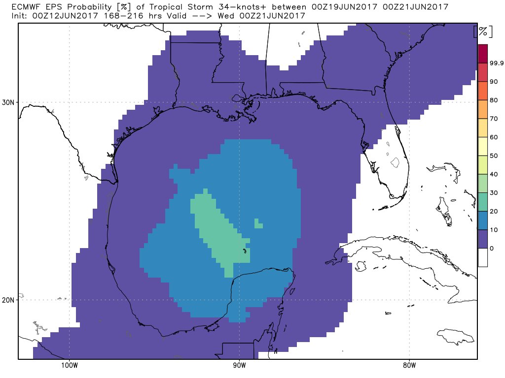
Confidence is slowly increasing regarding the potential for Tropical Development. during the Week 2 timeframe in the NW Caribbean Sea and the Western Gulf of Mexico.
- Attachments
-
Carla/Alicia/Jerry(In The Eye)/Michelle/Charley/Ivan/Dennis/Katrina/Rita/Wilma/Humberto/Ike/Harvey
Member: National Weather Association
Facebook.com/Weather Infinity
Twitter @WeatherInfinity
Member: National Weather Association
Facebook.com/Weather Infinity
Twitter @WeatherInfinity

GFS is still sniffing out the Western Gulf low.

GEM has a more powerful and eastward solution.

who knows what...but something is brewing.
GEM has a more powerful and eastward solution.
who knows what...but something is brewing.
-
Andrew
- Site Admin
- Posts: 3440
- Joined: Wed Feb 03, 2010 9:46 pm
- Location: North-West Houston
- Contact:
Models (GFS first) have been hinting at development over the past 3-5 days and the EURO is jumping on board slightly. I remain skeptical on what will develop with the time of the year and the foretasted environment in the BOC and gulf in general. In 3-5 days if development still looks likely from a model standpoint then I think more observation will be needed.
For Your Infinite Source For All Things Weather Visit Our Facebook
-
srainhoutx
- Site Admin
- Posts: 19616
- Joined: Tue Feb 02, 2010 2:32 pm
- Location: Maggie Valley, NC
- Contact:
Remember this potential is a broad monsoonal gyre or "spin" where we cannot accurately determine exactly where/when or if and TC will organize. This monsoonal gyre is rather well modeled and the synoptic setup regarding the MJO and CCKW are artifacts that tend to provide some mild confidence that the pattern will need to be monitored. Keep an eye on the trends this week to see if in fact there is some validity to what the reliable models are 'sniffing out'.
Levi Cowan @TropicalTidbits · 23m23 minutes ago
Models still moving monsoon gyre into W Carib or BOC end of next week. Still uncertain 8-10 day forecast, but this time not just a GFS error
Levi Cowan @TropicalTidbits · 23m23 minutes ago
Models still moving monsoon gyre into W Carib or BOC end of next week. Still uncertain 8-10 day forecast, but this time not just a GFS error
Carla/Alicia/Jerry(In The Eye)/Michelle/Charley/Ivan/Dennis/Katrina/Rita/Wilma/Humberto/Ike/Harvey
Member: National Weather Association
Facebook.com/Weather Infinity
Twitter @WeatherInfinity
Member: National Weather Association
Facebook.com/Weather Infinity
Twitter @WeatherInfinity
Still a few days before modeling gets into the medium range and more reason to take it seriously. The 18z GFS does create some chatter for the lower Texas coast folks. Needless to say the GFS can turn on a dime on any subsequent run. ;
Starting with the 0z runs tomorrow night is when it might be time to start going 'hmm.' With the slop type of setup this is, it can easily never amount to anything....
Starting with the 0z runs tomorrow night is when it might be time to start going 'hmm.' With the slop type of setup this is, it can easily never amount to anything....
-
Texaspirate11

- Posts: 1278
- Joined: Tue Dec 31, 2013 12:24 am
- Contact:
HGX doesn't seem too excited but reminds us to stay prepared.
Disco Saturday evening
TROPICS...
The GFS, Canadian and ECMWF all show some type of low pressure
system trying to develop in the southern Gulf of Mexico late next
weekend into the following week (June 18/19). Models diverge
significantly on the eventual track and intensity of the system.
Models tend to over forecast these systems (days 7-10) particularly
early in the tropical season. It`s always a good idea to keep up
with the latest forecasts and stay prepared during hurricane
season. 43
Just because you're disabled, you don't have to be a victim
Be Weather Aware & Prepared!
Barbara Jordan Winner in Media
Disability Integration Consultant
Be Weather Aware & Prepared!
Barbara Jordan Winner in Media
Disability Integration Consultant
-
srainhoutx
- Site Admin
- Posts: 19616
- Joined: Tue Feb 02, 2010 2:32 pm
- Location: Maggie Valley, NC
- Contact:
Looking at the overnight synoptic pattern and what the reliable Global deterministic and Ensemble Guidance suggests, one can see the beginning of the very broad spin and lowering pressures across Central America and Southern Mexico that extends from the Eastern Pacific where 92E has been designated by the NHC and is giving that area of disturbed weather a Medium to High Chance of organizing into a Tropical Cyclone near the Gulf of Tehuantepec.

Tropical Weather Outlook
NWS National Hurricane Center Miami FL
500 AM PDT Sun Jun 11 2017
For the eastern North Pacific...east of 140 degrees west longitude:
1. Showers and thunderstorms continue to become better organized in
association with an area of low pressure located a couple of
hundred miles south-southeast of Salina Cruz, Mexico. Additional
development is possible during the next day or two and this system
could become a tropical depression while it moves slowly
west-northwestward to northwestward toward the coast of southern
Mexico. Regardless of development, locally heavy rains are expected
to spread over the coasts of El Salvador, Guatemala, and
southeastern Mexico during the next few days.
* Formation chance through 48 hours...medium...60 percent.
* Formation chance through 5 days...high...70 percent.
Forecaster Cangialosi/Pasch
Just looking at the Ensembles, one can see that is monsoonal gyre or spin could be capable of developing several spurious low pressure systems at the surface as the rotate around the monsoonal gyre. The ECMWF EPS suggests rather low pressures at both the Lower and Upper Levels across the Western Gulf associated with this monsoonal gyre.
The 06 GEFS also suggest a very similar pattern, both at the Surface and the Upper Levels with the exception of a surface low attempting to organize in near Belize.
Another Hemispheric indicator we examine when analyzing the synoptic pattern is the placement or impacts of the Madden Julian Oscillation (MJO) and are conditions favorable for rising air that assist in developing Tropical Thunderstorms. The MJO is somewhat favorable during the timeframe that we are monitoring.
Another feature is a Convectively Coupled Kelvin Wave (CCKW) which further assists in Tropical Thunderstorm development and this feature too is in a favorable position.
While our sensible weather is yet to be determined, one can investigate the synoptic pattern and clearly see that it is worth monitoring. I have mention before that June can throw a curveball when tropical disturbances attempt to organize in/near the Gulf of Tehuantepec as well as the Gulf of Honduras, Yucatan Peninsula and the Bay of Campeche. We will continue to monitoring regardless of Tropical Cyclone development or not. We live in an age with excellent satellite coverage and improved Guidance that should prevent anyone from being surprised with little advance warning of potential Tropical Troubles spinning up with little warning and lead time.
Tropical Weather Outlook
NWS National Hurricane Center Miami FL
500 AM PDT Sun Jun 11 2017
For the eastern North Pacific...east of 140 degrees west longitude:
1. Showers and thunderstorms continue to become better organized in
association with an area of low pressure located a couple of
hundred miles south-southeast of Salina Cruz, Mexico. Additional
development is possible during the next day or two and this system
could become a tropical depression while it moves slowly
west-northwestward to northwestward toward the coast of southern
Mexico. Regardless of development, locally heavy rains are expected
to spread over the coasts of El Salvador, Guatemala, and
southeastern Mexico during the next few days.
* Formation chance through 48 hours...medium...60 percent.
* Formation chance through 5 days...high...70 percent.
Forecaster Cangialosi/Pasch
Just looking at the Ensembles, one can see that is monsoonal gyre or spin could be capable of developing several spurious low pressure systems at the surface as the rotate around the monsoonal gyre. The ECMWF EPS suggests rather low pressures at both the Lower and Upper Levels across the Western Gulf associated with this monsoonal gyre.
Carla/Alicia/Jerry(In The Eye)/Michelle/Charley/Ivan/Dennis/Katrina/Rita/Wilma/Humberto/Ike/Harvey
Member: National Weather Association
Facebook.com/Weather Infinity
Twitter @WeatherInfinity
Member: National Weather Association
Facebook.com/Weather Infinity
Twitter @WeatherInfinity
Gyre cranking up on the Pacific side of Mexico, not unusual. GFS, GEM, and Euro still persist on a Gulf low developing around the 20th. Some activity in the Gulf this afternoon along an old boundary.


Predictions this far out are dicey...but the persistence and consistency across models...should raise a skeptical eyebrow.
Predictions this far out are dicey...but the persistence and consistency across models...should raise a skeptical eyebrow.
-
srainhoutx
- Site Admin
- Posts: 19616
- Joined: Tue Feb 02, 2010 2:32 pm
- Location: Maggie Valley, NC
- Contact:
No real changes overnight via the reliable guidance concerning the monsoonal gyre expected to organize over Central America/Southern Mexico. What remains to be seen if anything warm cored/closed surface low will consolidates into a TC. As we have repeatedly stated, these monsoonal gyres are very difficult and complicated to forecast with any certainty.Regardless of any development, copious rainfall is possible across the NW Caribbean/Yucatan Peninsula and the Southern/SW Gulf of Mexico beginning this weekend. We still have plenty of time to watch and wait regarding our sensible weather next week along the Western Gulf.
Philippe Papin @pppapin · 9m9 minutes ago
Replying to @MJVentrice
Thanks for the shoutout Mike! Based on diagnostics, system becomes broad/closed enough on GFS to become #CentralAmericanGyre on 18 June.
Replying to @MJVentrice
Thanks for the shoutout Mike! Based on diagnostics, system becomes broad/closed enough on GFS to become #CentralAmericanGyre on 18 June.
Carla/Alicia/Jerry(In The Eye)/Michelle/Charley/Ivan/Dennis/Katrina/Rita/Wilma/Humberto/Ike/Harvey
Member: National Weather Association
Facebook.com/Weather Infinity
Twitter @WeatherInfinity
Member: National Weather Association
Facebook.com/Weather Infinity
Twitter @WeatherInfinity
For those keeping score, in 8 days the Euro and GFS have a weak low off the Texas coast and GEM has a TC off the Louisiana coast. Solutions have in general, moved west. Cantore and TWC, fwiw, jumped on the bandwagon this am.
The dreaded AccuWeather piled on Gyre-watching today as well, with low wind shear expect next week.
"Wind shear is likely to remain significant in the potential development area from the western Caribbean to the Gulf of Mexico this week," according to AccuWeather Hurricane Expert Dan Kottlowski.
However, weakening wind shear may open the door for possible development in the area next week.
“Thunderstorm activity is expected to enhance over Central America next week, and a south-to-north steering flow will provide the opportunity to pull this activity northward toward the Gulf of Mexico,” according to AccuWeather Meteorologist Evan Duffey.
The lowering wind shear may produce a suitable environment for development somewhere from the northwestern Caribbean to the southwestern Gulf of Mexico during June 18-24.

Ed Vallee
@EdValleeWx
Follow
More
Probability for some TC development stands at ~25% per latest European data in the 6-10 day period. Worth keeping an eye on. #tropics
We'll see.
The dreaded AccuWeather piled on Gyre-watching today as well, with low wind shear expect next week.
"Wind shear is likely to remain significant in the potential development area from the western Caribbean to the Gulf of Mexico this week," according to AccuWeather Hurricane Expert Dan Kottlowski.
However, weakening wind shear may open the door for possible development in the area next week.
“Thunderstorm activity is expected to enhance over Central America next week, and a south-to-north steering flow will provide the opportunity to pull this activity northward toward the Gulf of Mexico,” according to AccuWeather Meteorologist Evan Duffey.
The lowering wind shear may produce a suitable environment for development somewhere from the northwestern Caribbean to the southwestern Gulf of Mexico during June 18-24.
Ed Vallee
@EdValleeWx
Follow
More
Probability for some TC development stands at ~25% per latest European data in the 6-10 day period. Worth keeping an eye on. #tropics
We'll see.
-
srainhoutx
- Site Admin
- Posts: 19616
- Joined: Tue Feb 02, 2010 2:32 pm
- Location: Maggie Valley, NC
- Contact:
Monday morning briefing from Jeff:
Elevated rain chances today before a more typical summer pattern establishes the rest of the week
Attention will focus on the Gulf of Mexico by this weekend for any possible tropical cyclone formation
Upper level low over SE TX this morning with deep tropical moisture surging up its eastern flank and into the areas along and just east of I-45. Trigger temperatures in the 84-86 degree range should result in the formation of showers and thunderstorms by early afternoon across areas mainly east of I-45 where moisture is highest. Looking at a pretty strong rainfall gradient across SE TX from west (20%) to east (50-60%) this afternoon.
Flat upper level ridging begins to build over the area tonight into Tuesday which should cut back on rain chances and result in typical summer heat and humidity. Will carry 20-30% for seabreeze storms each afternoon.
Forecast begins to become complicated by late in the week and certainly into next weekend/beyond as another upper trough may want to develop over the TX coast which would beat back the upper ridge and allow a return of deeper moisture and rain chances. Models have not been very consistent on where this trough forms as that will have a determining factor on just how high rain chances may go.
Tropics:
Models continue to forecast the formation of a large monsoon trough and actual surface low across the W Caribbean Sea/southern Gulf of Mexico by this weekend. It is worth noting that nearly all global model guidance is now suggesting this feature and have remained fairly steady with the date of formation for several days now. Big question is where exactly does any surface low form and how does it interact with the landmasses of MX and central America. General consensus is that something will be moving out of the W Caribbean Sea on a general WNW/NW track into the southern Gulf of Mexico by late this weekend or first of next week. System is looking fairly large on models which is common of monsoon lows. If models continue with these trends into the middle and end of this week will need to start taking a look at potential for a tropical system in the Gulf of Mexico next week and what if any impacts such a system might have along the TX coast. Something to closely watch over the next few days.
Now would be a good time to remind residents that it is hurricane season and to check your hurricane preparation plans and kits.
Carla/Alicia/Jerry(In The Eye)/Michelle/Charley/Ivan/Dennis/Katrina/Rita/Wilma/Humberto/Ike/Harvey
Member: National Weather Association
Facebook.com/Weather Infinity
Twitter @WeatherInfinity
Member: National Weather Association
Facebook.com/Weather Infinity
Twitter @WeatherInfinity
-
tireman4
- Global Moderator
- Posts: 4488
- Joined: Wed Feb 03, 2010 9:24 pm
- Location: Humble, Texas
- Contact:
Tropical on the bottom. The HGX NWS agrees with Steve and Jeff's forecast...
000
FXUS64 KHGX 121550
AFDHGX
Area Forecast Discussion
National Weather Service Houston/Galveston TX
1050 AM CDT Mon Jun 12 2017
.UPDATE...
Temps are warming rather quickly this morning and 12z soundings
support max temps between 91-93 degrees so bumped temps up a
degree or two in some spots. Satellite derived PW fields show
quite a moisture gradient across SE TX this morning with the
higher moisture confined to areas east of I45. Current forecast
has a good handle on rain chances and will leave the PoP forecast
as is. 43
&&
.PREV DISCUSSION... /ISSUED 620 AM CDT Mon Jun 12 2017/
AVIATION [12Z TAF Issuance]...
Scattered showers are erupting across Southeast Texas, a bit
earlier and over a bit wider area than expected. Because of this,
moved up VCSH references, and expanded them areawide for at least
a time. At this time, still expect most significant rainfall to be
safely east of all TAF sites, and so dropped the PROB30 lines
rather than convert them to TEMPO.
Otherwise, transient IFR/MVFR ceilings should improve to VFR later
this morning. However, winds will increase and could gust into the
middle/upper teens, particularly from the Houston sites coastward.
Rain activity should largely settle down towards sunset. Expect a
return of at least MVFR ceilings again tonight, and can`t rule
out a new round of light showers overnight for the Houston and
coastal sites.
PREV DISCUSSION /Issued 348 AM CDT Mon Jun 12 2017/...
NEAR TERM [Through Today]...
As on Sunday, focus for rain today will continue to be east of the
Houston metro as an upper low drifts through the area while being
sheared out. Radar shows a line of showers and storms in the Gulf
waters right on our eastern border, generally streaming towards
shore. While the focus will be to our east, that doesn`t mean
we`ll be totally dry. I would expect some showers manage to crop
up at some point today in the area. However, it`s very clear that
there will be a sharp east-west gradient in precip chances, and
though I cautiously spread slight chance PoPs across the entire
area, look for isolated rain at the very best much farther west of
Houston.
In the meantime, some patchy fog and/or low stratus is cropping
up around the area, particularly north and west of the Houston
metro where there may be more subsidence (or at least, less lift)
associated with this compact upper low`s circulation. Would expect
and fog and low stratus to dissipate/lift pretty quickly as the
sun rises and encourages vertical mixing through heating. Expect
highs this afternoon to be in the general vicinity of seasonal
averages - perhaps a touch cooler, but just a touch.
SHORT TERM [Tonight Through Wednesday]...
Corrected for temperature range on Wednesday
We should dry out tonight in general, though less stability over
the waters should imply some nocturnal showers or a storm
overnight there. As the moderate onshore winds continue through
the night, dewpoints will stay high and keep overnight lows warm
and humid. Forget air you can wear, you may burn some extra
calories having to swim through this goop.
Despite the warm start, temperatures should still end up
relatively near seasonal averages on Tuesday. We will get another
shot for rain showers, and as the upper low loses definition and
begins to wash out, we`ll also likely lose that tight east-west
gradient in precip chances from Sunday and Monday. Instead,
isolated to scattered showers and storms will be possible in
something more approximating the typical summertime pattern.
Wednesday will also resemble Tuesday, but with more isolated
shower activity and possibly a thunderstorm expected. But, by this
point upper ridging will be taking control, with the 590 dm line
at 500 mb extending past SE Texas and into Eastern Louisiana. Not
only will this cut down on rain chances, but allow temperatures to
push into the lower 90s for all but coastal areas.
LONG TERM [Wednesday Night Through Monday]...
Thursday into Friday upper level ridging retrogrades as northwest
flow aloft develops in response to a broad trough axis that extends
from the Great Lakes through the Mississippi River Valley. This
allows for a shortwave trough to push into SE Texas on Friday. The
GFS still seems to be a bit stronger with the vorticity maximum than
the ECMWF/CMC however models have backed of from developing much
precipitation. The main reason for this is that precipitable water
values drop closer to 1.5 inches. Capping should be weaker on Friday
with lower heights aloft and the ridge over Mexico. GFS has CAPE
around 3000 J/kg and deep layer shear around 25-30kts so a few
strong/severe storms may be possible if there is enough lift. There
in lies the problem. With decreasing overall moisture and perhaps
not enough lift, forecast models are not producing much
precipitation. Forecast will keep 20/30 PoPs even though model
guidance is less. Saturday through Monday the GFS/ECMWF both have
another upper level low or shear axis forming over the region which
will support at least some chance of storms. Any thunderstorm
activity should be isolated in coverage and diurnally driven.
Overpeck
MARINE...
Showers and thunderstorms have increased this morning from near
42035 buoy to the Flower Garden Banks. This convection may be
enhancing winds and seas briefly with wind speeds up to 15 to 20
knots. Most buoys are showing winds around 15 knots or less. The
general trend is for winds to decrease this morning so will not have
any small craft exercise cautions. Overall the forecast has not
changed much for winds and seas this week. Winds and seas are
expected to increase again tonight and will have to monitor for more
persistent caution conditions. Beyond Tuesday, southeast winds will
prevail at around 10 to 15 knots, closer to 15 knots at night time
with the nocturnal increase. The pressure gradient does loosen for
the end of the week so winds may be closer to 10 knots with low seas.
Overpeck
TROPICAL...
Southwest to west shear will remain over the Gulf through the week.
Shear may weaken enough next Monday with an upper level low over the
Texas Gulf coast. GFS/ECMWF/CMC are hinting at some slow tropical
development over the NW Caribbean. This is still on days 7-8 of the
forecast period. Models seem to be picking up on some type of
easterly wave that moves across Central America during the week and
the turns north into the NW Caribbean for the weekend. It then moves
over the Yucatan on Sunday and emerge in the Gulf next Monday.
Depending upon the environment, there may not even be a system after
it moves over land. Even its initial development in the NW Caribbean
will be challenging given that it quickly emerges from Central
America into the Caribbean and quickly moves inland. There are
certainly a lot more hindrances to tropical development at this
stage and expect widely different model solutions for this situation.
Overpeck
&&
.PRELIMINARY POINT TEMPS/POPS...
College Station (CLL) 91 75 91 75 92 / 20 10 30 10 20
Houston (IAH) 90 78 90 77 90 / 40 30 40 10 20
Galveston (GLS) 88 82 87 82 86 / 40 20 30 10 20
&&
.HGX WATCHES/WARNINGS/ADVISORIES...
TX...NONE.
GM...SMALL CRAFT SHOULD EXERCISE CAUTION from 7 PM CDT this evening
through Tuesday morning for the following zones: Coastal
waters from Freeport to the Matagorda Ship Channel out 20
NM...Coastal waters from High Island to Freeport out 20
NM...Waters from Freeport to the Matagorda Ship Channel
from 20 to 60 NM...Waters from High Island to Freeport from
20 to 60 NM.
&&
-
Andrew
- Site Admin
- Posts: 3440
- Joined: Wed Feb 03, 2010 9:46 pm
- Location: North-West Houston
- Contact:
Looks like currently models are indicating two different paths this storm could take (if it develops at all). A weakness over the central/western gulf is expected to remain over the region through the weekend. How fast that shortwave moves west and ridging builds will determine if a more westward track will occur. I still think shear will remain an issue over the gulf through early next week and development (if any) will be slow with such a circulation.
For Your Infinite Source For All Things Weather Visit Our Facebook
The trend starting with the 0z runs has been further S and W. The 12z set continues that and models bury it in the BoC and into Mexico before any real development can occur. Actually surprised there hasn't been more wild swings with the modeling with this system born from slop (monsoonal gyre.)
Bottom line is that all the models that are used as tools has been seeing something for days now. Could easily swing back to a potential WGOM possibility or nothing but an EPAC issue, if anything at all.
Bottom line is that all the models that are used as tools has been seeing something for days now. Could easily swing back to a potential WGOM possibility or nothing but an EPAC issue, if anything at all.
-
srainhoutx
- Site Admin
- Posts: 19616
- Joined: Tue Feb 02, 2010 2:32 pm
- Location: Maggie Valley, NC
- Contact:
The afternoon Updated Weather Prediction Center Day3 through 7 surface charts do suggest a tropical wave nearing the Western Caribbean that eventually develops a surface low near Belize that meanders generally. WNW to NW entering the Bay of Campeche.
- Attachments
-
Carla/Alicia/Jerry(In The Eye)/Michelle/Charley/Ivan/Dennis/Katrina/Rita/Wilma/Humberto/Ike/Harvey
Member: National Weather Association
Facebook.com/Weather Infinity
Twitter @WeatherInfinity
Member: National Weather Association
Facebook.com/Weather Infinity
Twitter @WeatherInfinity
-
- Information
-
Who is online
Users browsing this forum: Ahrefs [Bot], Bing [Bot], Semrush [Bot] and 73 guests