

Are we done with the sea breeze storms today?
Got a good one here earlier, but radar seems pretty quiet, even with all the Gulf moisture out there.
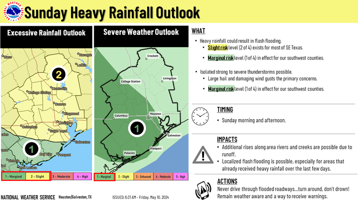
June 2017: Typical Summertime WX To End Month

Rip76 wrote:Are we done with the sea breeze storms today?
Got a good one here earlier, but radar seems pretty quiet, even with all the Gulf moisture out there.
Mostly in the NW HGX region. Teasing College Station at the moment.

Praise the Lord and pass the ammunition? Surge of Tropical moisture on the way.
Won the jackpot! Scored 1.4 in of rain in 20 min IMBY. As heavy a downpour I've seen in CLL in a decade - sheets of rain lashing the yard...
...or driving through a cloudburst in Florida
...or driving through a cloudburst in Florida
Evening briefing from Jeff.
An upper level trough will bring widespread rains…some heavy to SE TX over the next 48 hours.
An upper level trough over NW TX will slowly drop SE toward SE TX while moisture surges inland from the Gulf of Mexico. Have seen several thunderstorms develop late this afternoon over the region along numerous outflow boundaries. Thus far storms have been very outflow dominant and not able to sustain themselves for much longer than 30 min to about an hour which has kept short duration rainfall totals under control. Short term guidance is not in good agreement on where or when additional storms will develop. Think the loss of heating will lead to a gradual decline in storms by mid evening, but surge of moisture arriving at the coast around 300am combined with any disturbances approaching from the W/SW could result in the formation of storms between 300-600am Sunday morning. Runs of the HRRR and TX TECH WRF model suggest this potential but do not really agree on a location. Appears this activity may fire along a surface trough along US 59, but that is highly questionable.
Depending on what happens early Sunday will likely dictate development later in the morning on into Sunday afternoon. Global models show widespread development once trigger temperatures in the lower 80’s are achieved, but meso models are not as aggressive likely because they develop more early morning activity which would tend to stabilize the air mass some….but not completely.
With high moisture levels remaining in place, slowing storm motions (10kts or less), general large scale lift, and a nearly saturated air column all point toward a heavy rainfall threat. Good news thus far continues to be the lack of any sustained surface trough or boundary which could anchor or stall convection greatly increasing the flash flood threat. Current thinking is that storms will continue to be outflow dominated with a quick 1-2 inches of rainfall in the stronger cells. Some of the meso models are pegging a couple 3-5 inch bullseyes over the region Sunday and Monday which suggest some sort of slow moving convection, but without any defined surface boundary in place (not saying one wont form at some point) think the threat for significant flash flooding is low. Main threat will be street flooding from intense short term rainfall rates.
Will continue with high rain chances Sunday night-Tuesday with the upper trough overhead shifting slowly toward the NW Gulf. Some sort of sustained boundary could form during this period over the region along with fairly favorable venting of the upper levels…so the heavy rainfall threat will be maintained.
Trough moves into the Gulf by Wednesday with a rare June cool front crossing the area. Dewpoints may fall into the 50’s by Thursday which is very rare for June.
Tropics:
Remains of eastern Pacific tropical storm are currently located over the Bay of Campeche where surface pressures have fallen to 1007mb. Surface circulation is evident on visible images, but strong WSW upper level winds are preventing convection from developing near this circulation. Not expecting any development from this feature.
Overall pattern across the Gulf will remain unsettle into middle June with surges of tropical moisture out of the Caribbean Sea and some interaction with troughs across the northern Gulf. Will need to continue to watch the Gulf into middle June.
Area Forecast Discussion
National Weather Service Houston/Galveston TX
712 PM CDT Sat Jun 3 2017
.AVIATION...
A few short term concerns. Scattered storms in Harris Co should be
in the vicinity of IAH for the next hour or two. Lightning, wind
gusts ~25kt and brief heavy rain the primary concern there.
Looking further north where a line of showers and embedded tstms
are situated from roughly Crockett to Brenham will be pivoting ese
thru the evening - likely making it thru UTS, CXO, and possibly
IAH between now and 11pm or so. Same type of impacts - brief heavy
rain limiting visby to 0.75-1.5nm, wind gusts ~30kt and lightning.
There are numerous boundaries running around, so brief collisions
will enhance overall strength at times.
Think we`ll probably see things start tapering off toward
midnight. After the precip, confidence as to whether cigs will
fill in and fall is low, so will keep prevailing at MVFR or higher
until trends are established. By mid/late morning Sunday, we
should see precip redeveloping and expand in areal coverage and
persist thru much of the day. Probably could have gone
categorical -ra vcts working after about 17z and will consider
that for the 6z package. Wide range on conditions expected, VFR
outside of convection, to IFR under the strongest cells. 47
&&
.PREV DISCUSSION... /ISSUED 339 PM CDT Sat Jun 3 2017/
Showers and thunderstorms ongoing this afternoon mainly along the
seabreeze now east of I-45 and starting to develop along the
Highway 59 corridor southwest of Richmond. Active storms over West
and North-Central Texas this afternoon in association with the
slow moving upper low near KFDR. Storms in SETX should continue to
expand inland and likely increase a little in coverage and
intensity with atmosphere becoming more unstable across the
northern CWA. Brief heavy downpours still possible this
afternoon/early evening.
Guidance is all over the place for tonight/Sunday. Storms that are
going on across TX not lining up well with most of the higher res
modeling and hence confidence is lower on how this plays out
overnight. Thinking the general trend should be southeastward as
the upper low detaches and drifts towards SETX. Complex of storms
rolling down the Rio Grande will also add more uncertainty to the
forecast as some of this mass could shift eastward. WV/Vis imagery
showing the deeper moisture over the Gulf moving toward SETX/LA
and the leading edge of the deeper moisture should reach the
coastal areas by 03z. This should set the stage for slow moving
heavy rain as remnants of storms to the west die off during the
convective minimum and then leave a boundary to potentially help
focus storms along in the morning. Convective temperatures Sunday
82-83 which will be easily reachable. PW spiking up to 2-2.2"
should increase rainfall efficiency. Thinking the coverage will be
fairly widespread with pockets of heavy rains of 2 to 4 inches.
May lead to some isolated street flooding.
Upper low continues to track southeastward and should move through
the area Tuesday with a `cold front`. This should further
destabilize the airmass and lead to continued threat of slow
moving showers and thunderstorms Monday night/Tuesday. Eventually
Wednesday SETX gets on the back side of the upper low and coverage
should diminish with warming mid levels and drying in the lower
levels of the atmosphere thanks to weak high pressure building
into the area in the wake of the `June front`.
Thursday through Saturday looking pleasant for June with low pops
and heat index readings of 85-95. 45
mice little downpour here, nothing severe http://atmo.tamu.edu/ciams/lma/network_loop.html
https://twitter.com/iembot_hgx
Special Weather Statement
National Weather Service Houston/Galveston TX
840 PM CDT SAT JUN 3 2017
TXZ164-177>179-198-199-212-213-040245-
San Jacinto TX-Walker TX-Grimes TX-Waller TX-Polk TX-Harris TX-
Montgomery TX-Trinity TX-
840 PM CDT SAT JUN 3 2017
...Line of strong thunderstorms impacting the region through 930
PM CDT...
At 838 PM CDT, Doppler radar was tracking strong thunderstorms along
a line extending from 8 miles northwest of Montgomery to near Prairie
View. Movement was northeast at approximately 30 mph.
Half inch hail and winds in excess of 30 mph will be possible with
these storms.
Locations impacted include...
Huntsville, Willis, Prairie View, Pinehurst, Magnolia, New Waverly,
Pine Island, Point Blank, Montgomery, Riverside, Todd Mission,
Huntsville State Park, Lake Conroe Dam, Crabbs Prairie, Dobbin,
Oakhurst and Dacus.
PRECAUTIONARY/PREPAREDNESS ACTIONS...
Torrential rainfall is also occurring with these storms, and may lead
to localized flooding. Do not drive your vehicle through flooded
roadways.
Frequent cloud to ground lightning is occurring with these storms.
Lightning can strike 10 miles away from a thunderstorm. Seek a safe
shelter inside a building or vehicle.
These storms may intensify, so be certain to monitor local radio
stations and available television stations for additional information
and possible warnings from the National Weather Service.
Special Weather Statement
National Weather Service Houston/Galveston TX
114 AM CDT SUN JUN 4 2017
TXZ195>198-040645-
Brazos TX-Washington TX-Grimes TX-Burleson TX-
114 AM CDT SUN JUN 4 2017
...SIGNIFICANT WEATHER ADVISORY FOR SOUTHEASTERN BURLESON...NORTHERN
GRIMES...NORTHEASTERN WASHINGTON AND BRAZOS COUNTIES UNTIL 145 AM
CDT...
At 113 AM CDT, Doppler radar was tracking a strong thunderstorm 9
miles southwest of Millican, or 14 miles west of Navasota, moving
northeast at 35 mph.
Winds in excess of 40 mph will be possible with this storm.
Locations impacted include...
College Station, Bryan, Navasota, Washington, Somerville, Snook,
Kurten, Wixon Valley, Millican, Lake Somerville Dam, Kyle Field,
Independence, Wellborn, Roans Prairie and Carlos.
PRECAUTIONARY/PREPAREDNESS ACTIONS...
Torrential rainfall is also occurring with this storm, and may lead
to localized flooding. Do not drive your vehicle through flooded
roadways.
Frequent cloud to ground lightning is occurring with this storm.
Lightning can strike 10 miles away from a thunderstorm. Seek a safe
shelter inside a building or vehicle.
If on or near Lake Somerville, get out of the water and move indoors
or inside a vehicle. Remember, lightning can strike out to 10 miles
from the parent thunderstorm. If you can hear thunder, you are close
enough to be struck by lightning. Move to safe shelter now! Do not
be caught on the water in a thunderstorm.
&&
LAT...LON 3074 9647 3087 9639 3065 9588 3021 9624
3032 9656
TIME...MOT...LOC 0613Z 209DEG 28KT 3038 9633
-
Katdaddy

- Global Moderator

- Posts: 2502
- Joined: Thu Feb 04, 2010 8:18 am
- Location: League City, Tx
- Contact:
Flash Flood Warnings continue for Galveston and Chambers Counties as well as the Beaumont and Port Arthur areas as the heavy rains drift slowly offshore.
- Attachments
-
- Screen Shot 2017-06-04 at 11.41.36 AM.png (13.43 KiB) Viewed 4557 times
-
- Screen Shot 2017-06-04 at 11.42.20 AM.png (99.36 KiB) Viewed 4557 times

Over 5" and higher here in Bmt. Many roads closed due to flooding. Heaviest rains now moving east and offshore but another system to affect us later tonight/overnight and Monday and Tuesday. Hadnt had a drop of rain in 36 days but today it sure made up for it. Light rain now. Lighting and thunder were intense. Now just a constant rolling thunder. Nice for a relax and due nothing Sunday. Might take me a nap.
Mike
Beaumont, TX
(IH-10 & College Street)
Beaumont, TX
(IH-10 & College Street)

djmike wrote:Over 5" and higher here in Bmt. Many roads closed due to flooding. Heaviest rains now moving east and offshore but another system to affect us later tonight/overnight and Monday and Tuesday. Hadnt had a drop of rain in 36 days but today it sure made up for it. Light rain now. Lighting and thunder were intense. Now just a constant rolling thunder. Nice for a relax and due nothing Sunday. Might take me a nap.
Gotta love Texas. Feast or famine in the precipitation department.
Anyways attention shifts to our west as more develops for the afternoon and evening hours.
~~~When Thunder Roars Go Indoors~~~
~~~Turn Around Don't Drown~~~
~~~Run From The Water, Hide From The Wind~~~
~~~Turn Around Don't Drown~~~
~~~Run From The Water, Hide From The Wind~~~
No kidding. We had a month of nothing in April - May. A few busts in late May...then came up aces last night. 4 inches IMBY altogether in clusters...djjordan wrote:djmike wrote:Over 5" and higher here in Bmt. Many roads closed due to flooding. Heaviest rains now moving east and offshore but another system to affect us later tonight/overnight and Monday and Tuesday. Hadnt had a drop of rain in 36 days but today it sure made up for it. Light rain now. Lighting and thunder were intense. Now just a constant rolling thunder. Nice for a relax and due nothing Sunday. Might take me a nap.
Gotta love Texas. Feast or famine in the precipitation department.
Anyways attention shifts to our west as more develops for the afternoon and evening hours.
-
Texaspirate11

- Posts: 1278
- Joined: Tue Dec 31, 2013 12:24 am
- Contact:
Galvesotn experienced flooding this morning - now this area
Me? Here I am stuck in the middle with you: NADA
Take care y'all
Flash Flood Warning
National Weather Service Houston/Galveston TX
312 PM CDT SUN JUN 4 2017
The National Weather Service in League City has issued a
* Flash Flood Warning for...
Northeastern Fort Bend County in southeastern Texas...
Central Harris County in southeastern Texas...
* Until 515 PM CDT.
* At 310 PM CDT, trained weather spotters reported showers and
thunderstorms producing very heavy rain across the warned area.
Two to three inches of rain have already fallen, and an additional
2 to 4 inches are possible. Flash flooding is expected, especially
in the Sugar Land and Mission Bend areas.
* Some locations that will experience flooding include...
Sugar Land, Missouri City, eastern Rosenberg, Stafford, Bellaire,
West University Place, Jersey Village, Hunters Creek Village,
Bunker Hill Village, Piney Point Village, Northside / Northline,
Greenway / Upper Kirby Area, Spring Branch North, Greater Heights,
Town West, Memorial Park, Spring Branch West, First Colony, Spring
Valley and Afton Oaks / River Oaks Area.
PRECAUTIONARY/PREPAREDNESS ACTIONS...
Turn around, don`t drown when encountering flooded roads. Most flood
deaths occur in vehicles.
A Flash Flood Warning means that flooding is imminent or occurring.
If you are in the warned area move to higher ground immediately.
Residents living along streams and creeks should take immediate
precautions to protect life and property.
Just because you're disabled, you don't have to be a victim
Be Weather Aware & Prepared!
Barbara Jordan Winner in Media
Disability Integration Consultant
Be Weather Aware & Prepared!
Barbara Jordan Winner in Media
Disability Integration Consultant
-
srainhoutx

- Site Admin

- Posts: 19616
- Joined: Tue Feb 02, 2010 2:32 pm
- Location: Maggie Valley, NC
- Contact:
I have received almost 5 inches of rain since this morning. That makes my totals since last Sunday night/early Monday over 7 inches in the rain gauge. Will need to monitor the shortwave near Big Bend for additional heavy rainfall through tomorrow as that upper level feature drops SE into our Region.
MESOSCALE PRECIPITATION DISCUSSION 0297 NWS WEATHER PREDICTION CENTER COLLEGE PARK MD 353 PM EDT SUN JUN 04 2017 AREAS AFFECTED...SOUTHEAST TX CONCERNING...HEAVY RAINFALL...FLASH FLOODING POSSIBLE VALID 042000Z - 050000Z SUMMARY...SLOW MOVING HIGHLY EFFICIENT LINE OF CONVECTION MAY POSE SHORT-TERM FLASH FLOOD THREAT PARTICULARLY IN URBAN CORRIDOR/HOUSTON METROPLEX DISCUSSION...GOES-EAST WV LOOP DENOTES A WEAK TWIST OVER SOUTH-CENTRAL TX NEAR BAZ SHIFTING EAST. AHEAD OF IT MODEST DIFFLUENCE ALOFT FROM 5H AND ABOVE SUPPORTS BROAD SCALE ASCENT TO SUPPORT LOWER LEVEL CONVERGENCE ALLOWING FOR CONVECTIVE GROWTH AND MAINTENANCE OVER THE NEXT FEW HOURS. THE MCS THAT LEAD TO FF ALONG THE UPPER TX/W LA COAST THIS MORNING HAS KICKED AN OUTFLOW WEST THROUGH THE HOUSTON METRO DENOTED IN HGX REFLECTIVITY...THIS IS AN ADDED ELEMENT OF LOWER LEVEL CONVERGENCE WITH A NARROW AXIS OF ENHANCED INSTABILITY WHERE CLEAR SKIES THIS MORNING (NOT AFFECTED BY MCS CIRRUS SHIELD) SUPPORTED MID TO UPPER 80F TEMPS INCREASING MLCAPES FROM 1500-2500 J/KG (TOWARD THE COAST). SURFACE TDS IN THE LOW TO MID-70S AND FAIRLY SATURATED MID-LEVELS SUPPORT TPWS TO 2.0". AS SUCH PARAMETERS SUPPORT CONVECTION CAPABLE OF 2"/HR RAIN RATES. LOW LEVEL FLUX IS NOT TOO STRONG TO SUPPORT INCREASED RATES THOUGH ALSO ALLOWS FOR NEAR ZERO PROPAGATION VECTORS PER THE RECENT RAP AND WITH CLOUD BARING MEAN WINDS OF 10-15KTS IN A DIFFLUENT REGIME. CURRENT RADAR DENOTES THE OUTFLOW AS WELL AS THE MID-LEVEL TROF FORCING LINE ARE WELL ESTABLISHED AND LIKELY TO MERGE OVER THE NEXT HOUR IN PROXIMITY TO THE HOUSTON METRO WHERE FLASH FLOODING WILL BE MORE LIKELY. AS SUCH RAIN TOTALS OF 2-4" ARE POSSIBLE WITH SOME HI-RES CAMS SUGGESTING AS MUCH AS 5" WHICH MAY NOT BE FULLY RULED OUT GIVEN SLOW MOTIONS/RAINFALL EFFICIENCY AND MERGERS. TOWARD 23-00Z THE COMPLEX WILL MOVE THROUGH HOUSTON TOWARD SE TX AND WILL LIKELY REDUCE IN INTENSITY DUE TO STABILIZED ENVIRONMENT WITH LITTLE/NO RECHARGE FROM SOLAR INSOLATION AT PEAK HEATING. GALLINA ATTN...WFO...CRP...HGX...
MESOSCALE PRECIPITATION DISCUSSION 0297 NWS WEATHER PREDICTION CENTER COLLEGE PARK MD 353 PM EDT SUN JUN 04 2017 AREAS AFFECTED...SOUTHEAST TX CONCERNING...HEAVY RAINFALL...FLASH FLOODING POSSIBLE VALID 042000Z - 050000Z SUMMARY...SLOW MOVING HIGHLY EFFICIENT LINE OF CONVECTION MAY POSE SHORT-TERM FLASH FLOOD THREAT PARTICULARLY IN URBAN CORRIDOR/HOUSTON METROPLEX DISCUSSION...GOES-EAST WV LOOP DENOTES A WEAK TWIST OVER SOUTH-CENTRAL TX NEAR BAZ SHIFTING EAST. AHEAD OF IT MODEST DIFFLUENCE ALOFT FROM 5H AND ABOVE SUPPORTS BROAD SCALE ASCENT TO SUPPORT LOWER LEVEL CONVERGENCE ALLOWING FOR CONVECTIVE GROWTH AND MAINTENANCE OVER THE NEXT FEW HOURS. THE MCS THAT LEAD TO FF ALONG THE UPPER TX/W LA COAST THIS MORNING HAS KICKED AN OUTFLOW WEST THROUGH THE HOUSTON METRO DENOTED IN HGX REFLECTIVITY...THIS IS AN ADDED ELEMENT OF LOWER LEVEL CONVERGENCE WITH A NARROW AXIS OF ENHANCED INSTABILITY WHERE CLEAR SKIES THIS MORNING (NOT AFFECTED BY MCS CIRRUS SHIELD) SUPPORTED MID TO UPPER 80F TEMPS INCREASING MLCAPES FROM 1500-2500 J/KG (TOWARD THE COAST). SURFACE TDS IN THE LOW TO MID-70S AND FAIRLY SATURATED MID-LEVELS SUPPORT TPWS TO 2.0". AS SUCH PARAMETERS SUPPORT CONVECTION CAPABLE OF 2"/HR RAIN RATES. LOW LEVEL FLUX IS NOT TOO STRONG TO SUPPORT INCREASED RATES THOUGH ALSO ALLOWS FOR NEAR ZERO PROPAGATION VECTORS PER THE RECENT RAP AND WITH CLOUD BARING MEAN WINDS OF 10-15KTS IN A DIFFLUENT REGIME. CURRENT RADAR DENOTES THE OUTFLOW AS WELL AS THE MID-LEVEL TROF FORCING LINE ARE WELL ESTABLISHED AND LIKELY TO MERGE OVER THE NEXT HOUR IN PROXIMITY TO THE HOUSTON METRO WHERE FLASH FLOODING WILL BE MORE LIKELY. AS SUCH RAIN TOTALS OF 2-4" ARE POSSIBLE WITH SOME HI-RES CAMS SUGGESTING AS MUCH AS 5" WHICH MAY NOT BE FULLY RULED OUT GIVEN SLOW MOTIONS/RAINFALL EFFICIENCY AND MERGERS. TOWARD 23-00Z THE COMPLEX WILL MOVE THROUGH HOUSTON TOWARD SE TX AND WILL LIKELY REDUCE IN INTENSITY DUE TO STABILIZED ENVIRONMENT WITH LITTLE/NO RECHARGE FROM SOLAR INSOLATION AT PEAK HEATING. GALLINA ATTN...WFO...CRP...HGX...
Carla/Alicia/Jerry(In The Eye)/Michelle/Charley/Ivan/Dennis/Katrina/Rita/Wilma/Humberto/Ike/Harvey
Member: National Weather Association
Facebook.com/Weather Infinity
Twitter @WeatherInfinity
Member: National Weather Association
Facebook.com/Weather Infinity
Twitter @WeatherInfinity
https://twitter.com/HoustonOEM/status/8 ... 8334821376
.@cohoustonfire reporting many calls for help in stranded vehicles across the City. Wait for rain to clear before traveling. #houwx
.@cohoustonfire reporting many calls for help in stranded vehicles across the City. Wait for rain to clear before traveling. #houwx
Finally getting some rain here in Stafford. Last night we saw an awesome lightshow driving back from Angleton, but did not see a drop of rain.
We got zippo yesterday and none until about 45 mintues ago. I think we are making up for lost time now. It is coming down pretty good. But skies appear to be clearing.srainhoutx wrote:I have received almost 5 inches of rain since this morning. That makes my totals since last Sunday night/early Monday over 7 inches in the rain gauge. Will need to monitor the shortwave near Big Bend for additional heavy rainfall through tomorrow as that upper level feature drops SE into our Region.
http://cohweb.houstontx.gov/ActiveIncid ... bined.aspx
FD WILCREST DR 489U 06/04/2017 15:54 Water Rescue N
FD SYNOTT RD 528C 06/04/2017 15:52 Water Rescue N
FD LONG POINT RD BLK FOLEY ST 450U 06/04/2017 15:50 Water Rescue N
FD BRIARBROOK DR 489M 06/04/2017 15:44 Water Rescue N
FD KIMBERLEY LN 489G 06/04/2017 15:30 Water Rescue N
FD WILCREST DR 489U 06/04/2017 15:54 Water Rescue N
FD SYNOTT RD 528C 06/04/2017 15:52 Water Rescue N
FD LONG POINT RD BLK FOLEY ST 450U 06/04/2017 15:50 Water Rescue N
FD BRIARBROOK DR 489M 06/04/2017 15:44 Water Rescue N
FD KIMBERLEY LN 489G 06/04/2017 15:30 Water Rescue N
Looks like another line forming up near Victoria.
-
Texaspirate11
- Posts: 1278
- Joined: Tue Dec 31, 2013 12:24 am
- Contact:
Well, I got a spit and a holla' finally
but seeing how others were flooding out, I'm not complaining.
but seeing how others were flooding out, I'm not complaining.
Just because you're disabled, you don't have to be a victim
Be Weather Aware & Prepared!
Barbara Jordan Winner in Media
Disability Integration Consultant
Be Weather Aware & Prepared!
Barbara Jordan Winner in Media
Disability Integration Consultant
-
- Information
-
Who is online
Users browsing this forum: Ahrefs [Bot], Amazon [Bot], Bing [Bot] and 65 guests