
June 2017: Typical Summertime WX To End Month
-
srainhoutx

- Site Admin

- Posts: 19616
- Joined: Tue Feb 02, 2010 2:32 pm
- Location: Maggie Valley, NC
- Contact:
I see the 12Z ECMWF is back again with a weak surface reflection exiting the Bay of Campeche on Saturday generally drifting N into the NW Gulf by Sunday afternoon into early Monday.
- Attachments
-
Carla/Alicia/Jerry(In The Eye)/Michelle/Charley/Ivan/Dennis/Katrina/Rita/Wilma/Humberto/Ike/Harvey
Member: National Weather Association
Facebook.com/Weather Infinity
Twitter @WeatherInfinity
Member: National Weather Association
Facebook.com/Weather Infinity
Twitter @WeatherInfinity
-
Katdaddy

- Global Moderator

- Posts: 2502
- Joined: Thu Feb 04, 2010 8:18 am
- Location: League City, Tx
- Contact:
Welcome to the first day of the Atlantic Basin 2017 Hurricane Season.
EPAC TD 2 is making landfall along the MX Coast and adding to the moisture streaming across the GOM. Models have continued to advertise the potential of a weak low developing in the WGOM during the upcoming weekend.
Scattered showers and thunderstorms are moving across portions of SE TX this morning. Additional scattered activity is possible this afternoon and through the weekend.
- Attachments
-
- Screen Shot 2017-06-01 at 5.28.18 AM.png (62 KiB) Viewed 4996 times
-
- Screen Shot 2017-06-01 at 5.38.22 AM.png (194.65 KiB) Viewed 4996 times
-
srainhoutx
- Site Admin
- Posts: 19616
- Joined: Tue Feb 02, 2010 2:32 pm
- Location: Maggie Valley, NC
- Contact:
Thursday morning briefing from Jeff:
Active weather pattern will remain in place over the next several days.
Short wave overnight that produce a couple of rounds of showers and thunderstorms is progressing east of the region with rainfall generally ending over the area as slightly drier air sweeps northward from the Gulf of Mexico. Main question is do we see any re development of showers and thunderstorms with heating this afternoon. Weak subsidence behind the short wave will be in place through much of the morning hours, but as temperatures rise into the upper 70’s to lower 80’s expect a few showers and thunderstorms to develop. Should we get more heating than expected thunderstorms could become more numerous.
Expect overall less coverage of showers and thunderstorms on Friday and possibly Saturday with rain chances in the 30-40% range.
New surge of tropical moisture will arrive into the TX coast late Saturday into Sunday as northern fringe of current TD-2E in the eastern Pacific spreads northward across the western Gulf and into TX. Additionally another upper level trough will be approaching from the west at this time yielding lift across the moistening air mass. Not seeing any surface boundary to help focus heavy thunderstorms, but will have to keep an eye on any outflow boundaries that may be lingering over the region. The upper trough is looking slower and slower in model guidance which will keep rain chances going now well into next week.
Main threat over the next several days will continue to be locally heavy rainfall with PWS hovering around 1.8-2.0 inches and at times slow storm motions which could yield a quick 1-2 inches of rain.
Gulf of Mexico:
Today marks the start of the 2017 Atlantic basin hurricane season. Current season predictors including the forecasted state of El Nino, sea surface temperatures across the Atlantic, and forecasted moisture and sea level pressures this summer over the basin suggest a near normal to above average number of named storms for 2017. Most of these indicators have been trending more favorable for an active hurricane season over the last two months.
Tropical depression 2E currently over the eastern Pacific Ocean just south of the Mexican coast is moving NE this morning and will make landfall along the coast later today. Mid and high level moisture from this system is already expanding NNE across the southern Gulf of Mexico and some of this moisture will be brought northward toward the US Gulf coast over the weekend. Additionally, global forecast models show some sort of mid level circulation from TD 2E arriving into the southern Gulf of Mexico early this weekend and have off and on shown the formation of a surface reflection over the western Gulf by late this weekend. With an upper trough approaching TX by Sunday upper level winds across the NW/W Gulf should generally be unfavorable for development, but there is at least some potential for a weak sheared tropical system to attempt to form this weekend or early next week across the western Gulf of Mexico.
- Attachments
-
Carla/Alicia/Jerry(In The Eye)/Michelle/Charley/Ivan/Dennis/Katrina/Rita/Wilma/Humberto/Ike/Harvey
Member: National Weather Association
Facebook.com/Weather Infinity
Twitter @WeatherInfinity
Member: National Weather Association
Facebook.com/Weather Infinity
Twitter @WeatherInfinity

I got a welcome .76" overnight. Nice way to start the month of June.
-
MontgomeryCoWx

- Posts: 2356
- Joined: Wed Dec 14, 2011 4:31 pm
- Location: Weimar, TX
- Contact:
Frankly, if I get 1-2 inches of rain per month from June to August, I'm happy.
I'd prefer the June of 2007 as it was very cool and very rainy.
I'd prefer the June of 2007 as it was very cool and very rainy.
Team #NeverSummer
-
Texaspirate11

- Posts: 1278
- Joined: Tue Dec 31, 2013 12:24 am
- Contact:
I'm STILL waiting for rain....
Just because you're disabled, you don't have to be a victim
Be Weather Aware & Prepared!
Barbara Jordan Winner in Media
Disability Integration Consultant
Be Weather Aware & Prepared!
Barbara Jordan Winner in Media
Disability Integration Consultant

0.53" today out of 34 days. We need rain!!! This week or last has not been the deluge we were hoping for. 
Mike
Beaumont, TX
(IH-10 & College Street)
Beaumont, TX
(IH-10 & College Street)
-
srainhoutx
- Site Admin
- Posts: 19616
- Joined: Tue Feb 02, 2010 2:32 pm
- Location: Maggie Valley, NC
- Contact:
Picked up 1.4 Sunday into Monday...emptied .88 this evening. The crepe myrtles are loving it.
Carla/Alicia/Jerry(In The Eye)/Michelle/Charley/Ivan/Dennis/Katrina/Rita/Wilma/Humberto/Ike/Harvey
Member: National Weather Association
Facebook.com/Weather Infinity
Twitter @WeatherInfinity
Member: National Weather Association
Facebook.com/Weather Infinity
Twitter @WeatherInfinity
-
CrashTestDummy
- Posts: 187
- Joined: Mon Jul 25, 2016 3:44 pm
- Location: Pearland, Texas
- Contact:
I think we got a tenth, or so, this morning. Better than nuttin'. We could use a little more rain, but you have to be careful about what you ask for around here. The oaks are weeping, so we're at least getting enough for the established plants.
Gene Beaird,
Pearland, Texas
"You can learn a lot from a Dummy."
Pearland, Texas
"You can learn a lot from a Dummy."

Only 0.3 in out of 3-4 days. A lot of Lucy pulling away the football, as we were close to a few downpours. Really don't need a bust going into June. Last summer was brutal in July and the first half of August, but the ground was pretty saturated from May and June rains. Made a huge difference with the trees.djmike wrote:0.53" today out of 34 days. We need rain!!! This week or last has not been the deluge we were hoping for.
-
Katdaddy
- Global Moderator
- Posts: 2502
- Joined: Thu Feb 04, 2010 8:18 am
- Location: League City, Tx
- Contact:
A few scattered showers off the Upper TX Coast this morning. Additional isolated tropical showers and thunderstorms today and Saturday with the potential of more widespread rains Sunday and Monday. This morning’s satellite shows a stream of deep tropical moisture across MX and the GOM as well as a storm complex over SW TX.
- Attachments
-
- Screen Shot 2017-06-02 at 5.44.44 AM.png (222.43 KiB) Viewed 4945 times
-
srainhoutx
- Site Admin
- Posts: 19616
- Joined: Tue Feb 02, 2010 2:32 pm
- Location: Maggie Valley, NC
- Contact:
Friday morning briefing from Jeff:
Heavy rainfall ongoing across SW TX this morning as the next upper level trough approaches the state.
Moisture remains plentiful over the region today with trigger temperatures in the lower 80’s so expect to see showers and thunderstorms develop late morning into the afternoon hours as the seabreeze moves inland. Similar setup on Saturday with scattered pockets of thunderstorms and heavy rainfall.
Forecast becomes significantly more complicated Sunday-Tuesday as a slow moving upper level trough tries to cut off over TX. Deep tropical moisture (some from the tropical storm which made landfall over southern Mexico yesterday) will be brought northward into the TX coast late Sunday and especially on Monday. PWS surge to near 2.2 inches by Monday and this combined with the upper trough overhead is cause for concern with respect to heavy rainfall. CIPS analogs and hinting at the upper trough trying to become warm core as it sits in this tropical environment and this is certainly possible given a deep saturated level and very high PWS values along with generally weak winds aloft. Such systems in the past have produce excessive nocturnal core rains near their circulation centers as they begin to behave like a decaying tropical system. Position of this upper level feature would support excessive rainfall over SW/SC TX Sunday and then across SE TX late Sunday-Tuesday. Storm motions also drop off to less than 10kts during this period which is also concerning. Positive factor is that there does not appear to be any low level boundary in place to focus thunderstorms, but outflow boundaries and even the seabreeze this time of year can be the needed boundary to anchor and sustain convection.
Tropics:
Moisture plume from landfalling MX tropical storm is spread out across the entire Gulf of Mexico and aimed mainly at the central and eastern Gulf coast. Approach of the southern stream trough this weekend will help to redirect some of this moisture back NW toward the TX coast. Mid level vort center associated with the landfalling system still looks to moving into the Bay of Campeche at some point this weekend. Model solutions have generally backed away from any sort of surface low forming in the western Gulf, but this remains an area to at least keep an eye on through early next week.
Carla/Alicia/Jerry(In The Eye)/Michelle/Charley/Ivan/Dennis/Katrina/Rita/Wilma/Humberto/Ike/Harvey
Member: National Weather Association
Facebook.com/Weather Infinity
Twitter @WeatherInfinity
Member: National Weather Association
Facebook.com/Weather Infinity
Twitter @WeatherInfinity
-
tireman4

- Global Moderator
- Posts: 4488
- Joined: Wed Feb 03, 2010 9:24 pm
- Location: Humble, Texas
- Contact:
000
FXUS64 KHGX 021747
AFDHGX
Area Forecast Discussion
National Weather Service Houston/Galveston TX
1247 PM CDT Fri Jun 2 2017
.AVIATION...
Radar so far today looking a lot like yesterday. Convection along
the seabreeze continuing to move inland...with reports of locally
heavy rains and some funnel clouds. Will keep the mention of TSRA
in for central sites until 22Z (or so). Also going with MVFR CIGS
for the overnight/early Sat morning hours...but would not be that
surprised to see them go lower as they were last night/early this
morning. As for tomorrow, we will likely see a repeat of the SHRA
starting at the coast in the morning, and then slowly working its
way inland through the afternoon. 41
&&
.PREV DISCUSSION... /ISSUED 404 AM CDT Fri Jun 2 2017/
At 300 AM, sfc high pressure was located over the mid Mississippi
Valley with low pressure over eastern Colorado. Light onshore
winds persist under generally clear skies. This has allowed some
patchy fog to develop and have added morning fog to the wx grids.
Showers continue to increase over the Gulf this morning and a few
of these showers should make it to the coast around sunrise. Fcst
soundings show convective temps in the lower 80`s today and PW
values around 1.75 inches. Daytime heating should serve as a
catalyst for scattered showers and thunderstorms today. Storm
motion looks to be on the slow side and slow moving storms will
have the potential to produce locally heavy rain but widespread
heavy rain is not expected.
Some lingering showers will be possible into the evening but skies
are expected to clear by 03z and patchy fog will again be possible
especially areas to the southwest of Houston. Conditions on
Saturday look similar to today with scattered showers and
thunderstorms developing as temperatures warm into the middle 80s.
Rain chances will increase Sunday and Monday as an upper level
trough nears the region. Heights will fall and lift on the east
side of the upper low should give the region a good chance of
precipitation both days. Jet dynamics not looking terrific but
with PW values approaching 1.90 inches on Sunday and 2.10 inches
on Monday and convective temps in the lower 80`s, feel rain
chances will be high both days. Storm motion will be around 5
knots both days so locally heavy rain will remain a threat. The
ECMWF is a little more robust with the upper level system and this
feature is a bit worrisome as some fairly heavy nocturnal June
rain events have developed very close to the upper level low. CIPS
analog guidance shows several precip maximums near SE TX with
several of these between 2 and 4 inches of rain.
The upper trough axis lingers across SE TX on Tuesday but PW
values begin to drop and convective temps begin to warm. Both the
GFS and ECMWF are generous with QPF on Tuesday but signals in the
models would support drier conditions. PW values continue to dry
Wed-Fri and in the wake of a weak cold front that will cross the
area on Tuesday. Low temperatures will trend cooler over the
second half of next week but the drier air will heat efficiently
and afternoon highs should still warm to near 90 degrees each
afternoon. 43
&&
.PRELIMINARY POINT TEMPS/POPS...
College Station (CLL) 88 71 89 72 87 / 30 20 30 30 60
Houston (IAH) 88 74 89 74 87 / 50 20 30 20 60
Galveston (GLS) 85 79 87 80 86 / 30 20 30 20 50
&&
.HGX WATCHES/WARNINGS/ADVISORIES...
TX...NONE.
GM...NONE.
&&
$$
-
srainhoutx
- Site Admin
- Posts: 19616
- Joined: Tue Feb 02, 2010 2:32 pm
- Location: Maggie Valley, NC
- Contact:
Lots of tropical rainstorms around the Region and reports of several tropical funnels have been received. These storms are capable of dropping a quick inch or two wherever than move through. Copious deep and rich tropical moisture is surging toward the Texas Coast and PW's look to increase to above 2.2 inches which let's us know how deep and moist this tropical moisture is. It is also noteworthy that virtually all of the 12Z Global guidance suggest a wave of low pressure will advance North out of the Bay of Campeche ahead od a potent upper air disturbance on Sunday and Monday. The 1007mb low looks to move to near or just SW of Corpus as the shortwave exits Mexico into S Central Texas. Looks like an unsettled period may be ahead.

I will also note that the Ensembles suggest an Upper Ridge builds across the Northern Plains and Mid West with lowering pressures across the Gulf Of Mexico and a potential Easterly Wave cross the Gulf from East to West beneath that building Upper Ridge well to our North.
I will also note that the Ensembles suggest an Upper Ridge builds across the Northern Plains and Mid West with lowering pressures across the Gulf Of Mexico and a potential Easterly Wave cross the Gulf from East to West beneath that building Upper Ridge well to our North.
Carla/Alicia/Jerry(In The Eye)/Michelle/Charley/Ivan/Dennis/Katrina/Rita/Wilma/Humberto/Ike/Harvey
Member: National Weather Association
Facebook.com/Weather Infinity
Twitter @WeatherInfinity
Member: National Weather Association
Facebook.com/Weather Infinity
Twitter @WeatherInfinity
might mow the grass a little shorter ?
MIMIC TPW2 72 hrs: http://tropic.ssec.wisc.edu/real-time/m ... anim=html5
last 24 hrs
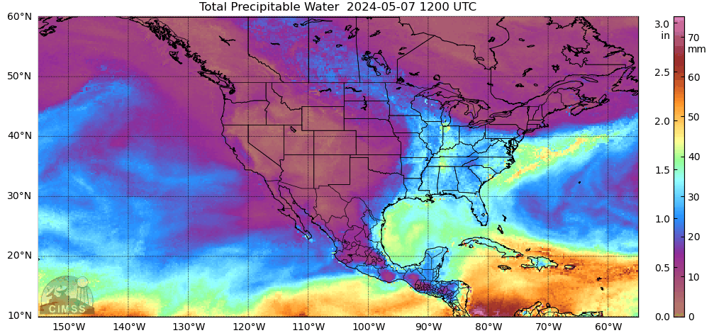
MIMIC TPW2 72 hrs: http://tropic.ssec.wisc.edu/real-time/m ... anim=html5
last 24 hrs
^^ That looks perrrttyyy.. Hope it gets here though. Everything I see shows most of the rain going to the East of Texas due to the Jet.
I think today will be a busy day. Convective temps are low and cells are already popping in this tropical airmass. I'm watching the outflow boundary to our north, along with activity out west.
-
srainhoutx
- Site Admin
- Posts: 19616
- Joined: Tue Feb 02, 2010 2:32 pm
- Location: Maggie Valley, NC
- Contact:
The current surface analysis suggest that a weak, highly sheared surface low has developed in the Bay of Campeche East of Veracruz and North of Tabasco. A trough extends N in the Western Gulf and along the Middle and Upper Texas Coast.
Sorry I cannot make the Hurricane Expo today, but I encourage those that have never attended to head down to the GRB and meet our NWS, Harris County Flood Control and other folks that are huge fans of our KHOU Weather Forum.
Sorry I cannot make the Hurricane Expo today, but I encourage those that have never attended to head down to the GRB and meet our NWS, Harris County Flood Control and other folks that are huge fans of our KHOU Weather Forum.
- Attachments
-
Carla/Alicia/Jerry(In The Eye)/Michelle/Charley/Ivan/Dennis/Katrina/Rita/Wilma/Humberto/Ike/Harvey
Member: National Weather Association
Facebook.com/Weather Infinity
Twitter @WeatherInfinity
Member: National Weather Association
Facebook.com/Weather Infinity
Twitter @WeatherInfinity

Interesting.
I would assume most of this weather would be pushed off to the East?
I would assume most of this weather would be pushed off to the East?
Did get a mention.

-
- Information
-
Who is online
Users browsing this forum: Ahrefs [Bot], Amazon [Bot], Semrush [Bot] and 65 guests