Re: April 2017 - MS 150 Forecast This Weekend
Posted: Fri Apr 28, 2017 3:53 pm
Continued questions about the cap, expectations of more of a linear storm mode, and expecting the storms around 4 a.m. (Sunday) in Houston itself, gone by probably 7-10 am.
Area Forecast Discussion
National Weather Service Houston/Galveston TX
318 PM CDT Fri Apr 28 2017
.SHORT TERM...
Today resembles more mid/late June than late April with
temperatures in the upper 80s to low 90s. Surface dewpoints are in
the low 70s so combined with the temperatures, heat index values
have reached the upper 90s this afternoon. The only thing that is
making it feel "cooler" are the winds which have been gusting to
30 mph at times. Gusty southerly winds will continue tonight which
means temperatures will not drop too much. Low temperatures in the
upper 70s look on track. This may break a few record high minimum
temperatures for Saturday but that may depend upon cooling
Saturday night as a cold front approaches. The strong winds will
certainly drive up tide levels and increase the threat for rip
currents through tomorrow.
Severe weather threat Saturday night...
Water vapor imagery and upper level analysis show a pretty strong
upper level low over the Great Basin which should drop south
towards the Southern Rockies by 12Z Saturday. A warm front should
extend from the Ozarks SW through Oklahoma to the Trans Pecos of
Texas with perhaps a couple small centers of low pressure along it
depending upon the evolution of convection tonight.
Upper level low should then move towards Tx/Ok Panhandles by 12Z
Sunday allowing for a broad area of large scale lift and height
falls to spread over the region. With this there will also be an
elevated mixed layer support capping over much of SE Texas
Saturday going into Saturday night. Upper level forcing may be
slow to spread over the area depending upon the track of the upper
low. Yesterday this lift looked out of phase with surface forcing
and suggest capping may hinder thunderstorm development. Cold
frontal forcing should be strong enough to at least initiate
linear convection with a squall line moving through the area.
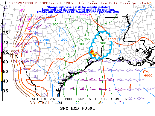
Models differ in instability but overall looks like CAPE over 2000
J/Kg will be possible Saturday night over SE Texas. Deep layer
shear near 40-50 knots may be increasing with strong low level
shear around 20-30 knots during the overnight time frame. This
suggests at least a small tornado threat if a discrete cell can
develop which with the frontal forcing look unlikely since the
cap will be eroding all along the front. Storm model looks linear
as suggested by several of the WRF models so feel confident with a
squall line support hail/damaging wind threats. Any tornado may
be brief and along the squall line. Once again this all depends
upon there being enough instability and that capping weakens.
Basic timing of the line of storms looks to be near midnight
Sunday for the College Station area, 4AM Sunday for Houston area
and off the coast 7-10AM Sunday. Temperatures will be dropping
behind the front into the 60s/50s for Sunday.
Last but not least, the flood threat does not look at great for SE
Texas. While there will be high precipitable water values near 2
inches, the axis of moisture looks to move east Saturday afternoon
and night which would support heavy rainfall more over NE Texas
into Arkansas. The line of storms may produce brief heavy rainfall
but the storms will be moving quickly through the area which will
limit the flood threat.