
April 2017 - MS 150 Forecast This Weekend
-
Katdaddy

- Global Moderator

- Posts: 2502
- Joined: Thu Feb 04, 2010 8:18 am
- Location: League City, Tx
- Contact:
A large area of light to moderate rain is moving off the Upper TX Coast behind the line of thunderstorms that moved across SE TX this afternoon. The rain was welcome along the Upper TX Coast who have missed some of the recent weather events so I will enjoy my 0.79" rainfall total. Areas across Central TX saw very heavy rains with flash flooding along with reports of hail and wind damage. Additional strong to occassionally severe storms are moving through STX this evening from NW and W of Corpus Christi to Laredo.
- Attachments
-
- Screen Shot 2017-04-11 at 7.08.55 PM.png (45.19 KiB) Viewed 4485 times
-
Katdaddy
- Global Moderator
- Posts: 2502
- Joined: Thu Feb 04, 2010 8:18 am
- Location: League City, Tx
- Contact:
A slight chance of a few isolated showers and thunderstorms today followed by partly cloudy to mostly sunny skies through Saturday across SE TX. Easter may see an increase in scattered showers and thunderstorms into early next week. A beautiful sunrise is likely the morning from streaming cirrus overhead from a mesoscale convective complex in Mexico.
- Attachments
-
- Screen Shot 2017-04-12 at 5.41.54 AM.png (89.71 KiB) Viewed 4409 times

Flood Advisory
National Weather Service Houston/Galveston TX
242 PM CDT WED APR 12 2017
TXC039-122145-
/O.NEW.KHGX.FA.Y.0048.170412T1942Z-170412T2145Z/
/00000.N.ER.000000T0000Z.000000T0000Z.000000T0000Z.OO/
Brazoria TX-
242 PM CDT WED APR 12 2017
The National Weather Service in League City has issued a
* Flood Advisory for...
Central Brazoria County in southeastern Texas...
* Until 445 PM CDT.
* At 242 PM CDT, Doppler radar indicated heavy rain due to
thunderstorms. This will cause minor flooding in the advisory area.
Up to two inches of rain have already fallen.
* Some locations that will experience flooding include...
West Columbia, Holiday Lakes and Bonney.
~~~When Thunder Roars Go Indoors~~~
~~~Turn Around Don't Drown~~~
~~~Run From The Water, Hide From The Wind~~~
~~~Turn Around Don't Drown~~~
~~~Run From The Water, Hide From The Wind~~~
-
Katdaddy
- Global Moderator
- Posts: 2502
- Joined: Thu Feb 04, 2010 8:18 am
- Location: League City, Tx
- Contact:
Patches of fog this morning so drive safely. Partly cloudy to mostly sunny skies today and Friday followed by some showers and a few thunderstorms Easter weekend through the early part of next week.
- Attachments
-
-
srainhoutx

- Site Admin

- Posts: 19616
- Joined: Tue Feb 02, 2010 2:32 pm
- Location: Maggie Valley, NC
- Contact:
Thursday morning briefing from Jeff:
Fairly typical mid April weather pattern in place for the next few days with lows in the 60’s and highs in the 80’s under partly cloudy and at times hazy skies.
Upper level pattern this morning has a ridge of high pressure over the eastern US which has backed WSW into SE TX overnight with a trough over the SW US. This is allowing for a weak SW flow in the upper levels across W/C TX and disturbances within this flow when combined with favorable moisture over the region have allowed for numerous showers and thunderstorms to our west overnight. This complex of storms has been weakening as it has moved into the TX Hill Country and progresses into a more stable air mass. However surface outflow boundaries may approach or move into our western counties (College Station to Victoria) by mid to late afternoon when the local air mass will be most unstable resulting in a few showers or thunderstorms.
SW flow aloft will continue into next week and surely disturbances will move across the state during this period. Global models are trying to resolve these small scale features which would tend to focus higher rain chances at certain times over the next few days. Latest indications are that Sunday into Monday will feature the highest rain chances, but will cap those at 30-40% for now given much uncertainty. It is getting to be that time of year where warmth and moisture along boundaries such as the seabreeze or outflow boundaries from storms well away from the area can result in widely varying forecasts.
Carla/Alicia/Jerry(In The Eye)/Michelle/Charley/Ivan/Dennis/Katrina/Rita/Wilma/Humberto/Ike/Harvey
Member: National Weather Association
Facebook.com/Weather Infinity
Twitter @WeatherInfinity
Member: National Weather Association
Facebook.com/Weather Infinity
Twitter @WeatherInfinity
-
tireman4

- Global Moderator
- Posts: 4488
- Joined: Wed Feb 03, 2010 9:24 pm
- Location: Humble, Texas
- Contact:
00
FXUS64 KHGX 130955
AFDHGX
Area Forecast Discussion
National Weather Service Houston/Galveston TX
455 AM CDT Thu Apr 13 2017
.DISCUSSION...
Scattered cirrus traveling across from the west...thick enough to
keep the majority of the forecast area from experiencing near
sunrise dense fog formation. A short fuse Dense Fog Advisory may
be needed for the eastern CWA or near coastal locations as local
visibilities have recently fallen to under a mile. No small nor
large scale surface boundaries...with upper ridging planted just
to our east (ridge axis is centered across Appalachia) and the
bulk of the lower to middle layer moisture positioned over southern
Texas...all suggest that today will be dry. There are slight
western county afternoon convective chances in relation to being
in the proximity of the eastern reaches of an early day west Texas
upper trough/shortwave disturbance passage. There is a remote
possibility that outflow from the QLCS that is pushing east across
SJT (or EWX`s) CWA this morning will be entering our warmed...moist
and unstable (west-southwestern county) afternoon environment. If
so...the day may end with scattered convection flaring up over the
Brazos River Valley and points south and west. A typical spring-
like day can be expected...southeast breezes and partially cloudy
skies as temperatures warm into the lower 80s by Noon.
Very little change in the synoptic pattern through Saturday...
generally lowering heights over the Great Basin will prime next
week`s weather. Very low Friday and Saturday PoPs to account for a
short-lived shower or an isolated storm that develops along the
local breezes...daily middle 60 minTs with daily lower to middle
80 maxTs as moisture/humidity levels remain bearable. The pattern
does begin to undergo some subtle change beginning Easter Sunday.
Shallow upper troughing across the Rockies may allow a shortwave
disturbance (or two) to pass across eastern Texas Sunday and Monday.
Heightened moisture levels pooling up within a persistent (PM)
conditionally unstable inland environment...will create a primed
early week set-up for the increased probability of enhanced shower
and storm activity. Global models are pegging Easter Sunday and
Monday as the days we are most likely to experience precipitation.
31
&&
.MARINE...
Persistent southeasterly winds 10-15kts & 3-5 ft seas should persist
for the next several days with a ridge of high pressure remaining
over the SE US. 47
&&
.AVIATION...
IFR/MVFR cigs & fog should begin lifting during the mid & late
morning hours as some drier llvl air makes its way into the region
from the se. VFR for the remainder of the day with just some cirrus
debris from w/n Tx precip streaming overhead. 47
&&
.PRELIMINARY POINT TEMPS/POPS...
College Station (CLL) 82 62 82 62 84 / 10 10 10 10 10
Houston (IAH) 82 63 82 65 82 / 10 10 10 10 20
Galveston (GLS) 78 70 78 69 78 / 10 10 10 10 20
&&
.HGX WATCHES/WARNINGS/ADVISORIES...
TX...NONE.
GM...NONE.
&&
$$
Discussion...31/47

Seems like the radar is a bit busier than forecast. The 'remote possibility' of storms to impact Brazos valley area not supposed to happen until this afternoon and look...
-
CrashTestDummy
- Posts: 187
- Joined: Mon Jul 25, 2016 3:44 pm
- Location: Pearland, Texas
- Contact:
Hopefully today's forecast doesn't get blown out of the water like yesterday's did. I'm not sure my property can survive another 10% chance of rain day! 
For now, though, it does look like that training 'stream' that dropped rain on Galveston Island and up the Gulf freeway all day yesterday, has shifted southward some.
For now, though, it does look like that training 'stream' that dropped rain on Galveston Island and up the Gulf freeway all day yesterday, has shifted southward some.
Gene Beaird,
Pearland, Texas
"You can learn a lot from a Dummy."
Pearland, Texas
"You can learn a lot from a Dummy."
-
brooksgarner

- Global Moderator
- Posts: 226
- Joined: Tue Jun 04, 2013 3:06 pm
- Location: Houston, TX
- Contact:
... it was a 20% chance yesterday.  Of course, for Pearland it was ultimately a 100% chance, but per the Houston viewing area and our official forecast to cover the region, we only saw about 20%-30% coverage.
  Agree though: my yard can't take another inch. We had 4.2" in the last 2 days.
Broadcast Met
http://BrooksGarner.com
http://twitter.com/BrooksWeather
http://BrooksGarner.com
http://twitter.com/BrooksWeather
- '17 Harvey
- '12 Sandy (P3 Orion)
- '91 Bob
- '85 Gloria
-
CrashTestDummy
- Posts: 187
- Joined: Mon Jul 25, 2016 3:44 pm
- Location: Pearland, Texas
- Contact:
I don't remember even seeing that in the zone forecast, but could have missed it. The models were showing a few pop-up showers, mostly 'splash and dash' showers, but not the training and constant raining all day long that we experienced.
It happens, but was annoying that it happened, again on the commute home for the second day in a row. Hopefully we're dry this afternoon.
It happens, but was annoying that it happened, again on the commute home for the second day in a row. Hopefully we're dry this afternoon.
Gene Beaird,
Pearland, Texas
"You can learn a lot from a Dummy."
Pearland, Texas
"You can learn a lot from a Dummy."
-
brooksgarner
- Global Moderator
- Posts: 226
- Joined: Tue Jun 04, 2013 3:06 pm
- Location: Houston, TX
- Contact:
I can't speak for the National Weather Service's zone forecasts... I mean our KHOU 11 news forecast.
Broadcast Met
http://BrooksGarner.com
http://twitter.com/BrooksWeather
http://BrooksGarner.com
http://twitter.com/BrooksWeather
- '17 Harvey
- '12 Sandy (P3 Orion)
- '91 Bob
- '85 Gloria
-
srainhoutx
- Site Admin
- Posts: 19616
- Joined: Tue Feb 02, 2010 2:32 pm
- Location: Maggie Valley, NC
- Contact:
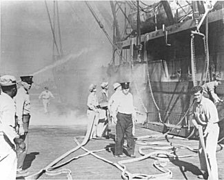
Easter Sunday marks the 70th Anniversary of one of the worst Industrial Accidents we have ever seen here in SE Texas. My Mom and Grandmother lost friends in the Texas City Disaster and I am sure that others on this Board can share experiences of their families on that fateful day, April 16, 1947.
- Attachments
-
Carla/Alicia/Jerry(In The Eye)/Michelle/Charley/Ivan/Dennis/Katrina/Rita/Wilma/Humberto/Ike/Harvey
Member: National Weather Association
Facebook.com/Weather Infinity
Twitter @WeatherInfinity
Member: National Weather Association
Facebook.com/Weather Infinity
Twitter @WeatherInfinity

This is probably the last pictures taken of my Grandfather. He was the Fire Chief for Texas City and was killed during the first explosion.
Growing up in Texas City, the disaster was talked about very often within the town.
I travel a lot for work in the state of Texas, and you would be amazed how many people don't even know about this.
This is a great website about the Texas City Disaster, with tons of information.
http://www.local1259iaff.org/disaster.html

Seems like we're moving from severe season to popcorn shower season a little earlier.jasons wrote:Seems like the radar is a bit busier than forecast. The 'remote possibility' of storms to impact Brazos valley area not supposed to happen until this afternoon and look...
There's certainly noise, but the thing I've noticed over the 25 years in the Brazos Valley in the Spring the frequency of rain is more intermittent, more variable (although, hey's it's Texas!)...and severe season seems to trend earlier and more variably. 10 year drought, CC, vagaries of Texas weather all at play. Never a dull moment...and many frustrating/exhilarating days in horticulture for sure.
Speaking of which...we got 1.4 in or rain IMBY with the recent storm...so I'm enjoying that week or two in April and the week or two in early October when everything around here is Green! Have a great Easter weekend.
Wow. I'm sorry to hear that, but it is an iconic image of heroes at work.Rip76 wrote:This is probably the last pictures taken of my Grandfather. He was the Fire Chief for Texas City and was killed during the first explosion.
Growing up in Texas City, the disaster was talked about very often within the town.
I travel a lot for work in the state of Texas, and you would be amazed how many people don't even know about this.
This is a great website about the Texas City Disaster, with tons of information.
http://www.local1259iaff.org/disaster.html
-
Katdaddy
- Global Moderator
- Posts: 2502
- Joined: Thu Feb 04, 2010 8:18 am
- Location: League City, Tx
- Contact:
I lost a great uncle in the second explosion of the S. S. High Flyer while he was helping rescue survivors of the first explosion. I remember my mom telling me she could see the black smoke from Pearland during recess in elementary school.
I too lost a great-uncle. He was a chemist with Monsanto who died in the first explosion.
Anyway, in more weather related things, it's kind of interesting that there's already something on the 8-day (for eastern Oklahoma/SE Kansas). You don't see that everyday.
It's also interesting reading the explanation. It seems like it reads as 'We don't really know what's coming, but whatever it is, it's looking bad, so we're putting something up already to make sure people pay attention.'.
Day 4-8 Convective Outlook
NWS Storm Prediction Center Norman OK
0359 AM CDT Fri Apr 14 2017
Valid 171200Z - 221200Z
...DISCUSSION...
A low-amplitude zonal flow pattern is evident early in the extended
period with predictability concerns for severe early in the work
week. By Wednesday (day 6), rich low-level moisture over the
western Gulf Basin will likely become established and indications
suggest an elevated mixed layer will reside over the plateau areas
in the southwest U.S./northern Mexico. Both medium-range
deterministic, time-lagged deterministic, and ensemble data suggest
increasing potential for the development of a trough over the
western U.S. during the Wednesday-Thursday period (days 6-7). While
significant spread in models on the evolution of the trough into the
central U.S. (ejecting shortwaves) are acknowledged given the long
time scales associated with this forecast, there appears to be
increasing probability for severe when a disturbance/mean
longitudinal trough position moves into the central-southern High
Plains. Given what appears to be several factors in a background
sense supporting an increased severe risk [i.e., projected mid-level
wave timing, meteorological (dryline, EML, moisture) and seasonal
climatology], have opted to include a 15% severe risk on Friday (day
8) to highlight severe potential for late in the extended period.
Refinements to the area on Friday (day 8) are an almost certainty in
later outlook updates as well as the possible inclusion of other
potential areas on other days.
- Attachments
-
- 8-day
- day8prob.gif (12.42 KiB) Viewed 5275 times
Wow, some impressive looking tornadoes in the panhandle today:
https://www.youtube.com/watch?v=Wz7AImzru5I
https://www.youtube.com/watch?v=mucfpddZd0U
https://www.youtube.com/watch?v=74IGf5GMa5I
https://www.youtube.com/watch?v=Wz7AImzru5I
https://www.youtube.com/watch?v=mucfpddZd0U
https://www.youtube.com/watch?v=74IGf5GMa5I


Texas City Disaster is the deadliest industrial accident in American history. 28 Texas City Firefighters were killed along with nearly 600 people. It was the deadliest for firefighters prior to 9/11, which claimed 343 at the World Trade Center.
Texas City Librar-1947 Texas City Disaster
http://www.texascity-library.org/disaster/first.php
Texas City Librar-1947 Texas City Disaster
http://www.texascity-library.org/disaster/first.php
hearing some rumbles out there !
http://weather.cod.edu/satrad/exper/?pa ... tx-13-48-1
http://weather.cod.edu/satrad/nexrad/in ... X-N0Q-1-48
https://www.harriscountyfws.org/
http://weather.cod.edu/satrad/exper/?pa ... tx-13-48-1
http://weather.cod.edu/satrad/nexrad/in ... X-N0Q-1-48
https://www.harriscountyfws.org/