

Today a clone of yesterday. Humid, followed by tanking dew point and drier, warm air with NW wind.
More seasonable for couple days, then a rain mode for a few days. Warm weekend, then seasonable early next week.
February 2017- Spring Like Weather Returns

-
srainhoutx

- Site Admin

- Posts: 19616
- Joined: Tue Feb 02, 2010 2:32 pm
- Location: Maggie Valley, NC
- Contact:
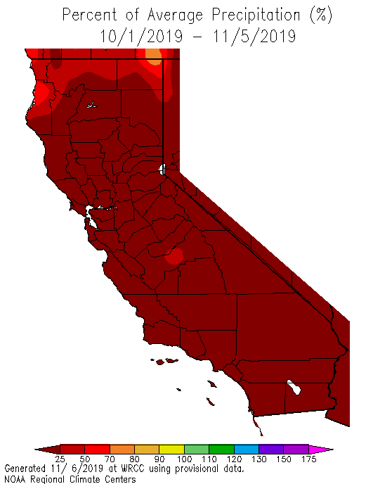
Starting to see some strong signals that a favorable MJO and Convectively Coupled Kelvin Wave will bring unsettled weather across drought parched California as well as Texas over the next 7 days.
- Attachments
-
Carla/Alicia/Jerry(In The Eye)/Michelle/Charley/Ivan/Dennis/Katrina/Rita/Wilma/Humberto/Ike/Harvey
Member: National Weather Association
Facebook.com/Weather Infinity
Twitter @WeatherInfinity
Member: National Weather Association
Facebook.com/Weather Infinity
Twitter @WeatherInfinity
Fortunately, this winter has been very good to Cali. Hoping to squeeze out as much precip as possible as climb catches up with the rainy season. LA area colleagues tell me it's rained more than in many a year...srainhoutx wrote:Starting to see some strong signals that a favorable MJO and Convectively Coupled Kelvin Wave will bring unsettled weather across drought parched California as well as Texas over the next 7 days.
-
Katdaddy

- Global Moderator

- Posts: 2502
- Joined: Thu Feb 04, 2010 8:18 am
- Location: League City, Tx
- Contact:
Last night's cool front has led to a much cooler morning across SE TX with temps mostly in the 50s under fair skies. It will feel a little more like February today but be ready for the warmth to return beginning tomorrow with highs in the upper 70s to near 80 again by Saturday. In addition, an unsettled weather pattern arrives this weekend into the first half of next week with increasing rain chances.
Katdaddy wrote:Last night's cool front has led to a much cooler morning across SE TX with temps mostly in the 50s under fair skies. It will feel a little more like February today but be ready for the warmth to return beginning tomorrow with highs in the upper 70s to near 80 again by Saturday. In addition, an unsettled weather pattern arrives this weekend into the first half of next week with increasing rain chances.
Low of 42°F IMBY.
haha - that's just average. Take what you can get this "winter."
-
Katdaddy
- Global Moderator
- Posts: 2502
- Joined: Thu Feb 04, 2010 8:18 am
- Location: League City, Tx
- Contact:
Spring-like weather returns again to SE TX. The warming trend is ongoing this morning across the Upper TX Coast. It was 51F in Pearland at 3AM and it is now up to 58F at 5AM. Expect highs into the the mid 70s this afternoon with some increasing clouds. Upper 70s to low 80s with partly to mostly cloudy skies for the weekend as well as increasing rain chances by Sunday. The first part of next week is looking very wet for SE TX with some areas of heavy rainfall Tuesday resulting in 1-3" totals and locally higher amounts.
Since Winter has vanished for now; here is a light snow photo from December 4, 2009 here in League City.
Since Winter has vanished for now; here is a light snow photo from December 4, 2009 here in League City.
- Attachments
-
-
srainhoutx
- Site Admin
- Posts: 19616
- Joined: Tue Feb 02, 2010 2:32 pm
- Location: Maggie Valley, NC
- Contact:
We will need to monitor the trends over the weekend for next Tuesday into Tuesday night for the possibility of some strong to severe thunderstorms as a potent 500mb upper low moves out of Mexico into Texas. The GFS indicates dewpoints in the low 60's mainly S and W of Metro Houston and rather impressive dynamics at multiple levels suggesting the potential for rotating updrafts if storm do form. We are several day away from this potential, but with warmer air at the surface and much colder air aloft to our West, the trends will need to be watch rather closely.
Carla/Alicia/Jerry(In The Eye)/Michelle/Charley/Ivan/Dennis/Katrina/Rita/Wilma/Humberto/Ike/Harvey
Member: National Weather Association
Facebook.com/Weather Infinity
Twitter @WeatherInfinity
Member: National Weather Association
Facebook.com/Weather Infinity
Twitter @WeatherInfinity
-
srainhoutx
- Site Admin
- Posts: 19616
- Joined: Tue Feb 02, 2010 2:32 pm
- Location: Maggie Valley, NC
- Contact:
Friday morning briefing from Jeff:
Powerful storm system will arrive into TX early next week
After one day of only slightly above normal temperatures…well above normal temperatures will return for the weekend as southerly winds bring moisture back into the region. A strong upper level storm system currently off the CA coast will move into the SW US this weekend and then slowly move into and across TX early next week. A cold front will move southward ahead of this storm system likely crossing the area sometime Sunday evening into Monday morning allowing a cooler air mass to filter southward. There are questions as to where this front will stall, but the latest thinking is that it will progress to near the coast by Monday.
Rain chances will start to increase late Sunday as the front moves into the region and moisture increases. Expect showers and possibly a few thunderstorms to develop as the front crosses the region along with some support from an approaching short wave.
Potent CA system will begin to eject toward TX late Monday with increasing jet dynamics aloft, increasing lift as a low level jet develops atop the surface cool pool and increasing moisture from both the Pacific and Gulf. I am starting to become concerned that the frontal boundary may attempt to lift northward as a warm front early on Tuesday although this is fairly uncertain at this range. This would produce a surface focus for slow moving thunderstorms and heavy rainfall and we have been burned many times before with these surface boundaries in such setups. Main threat time period looks to be from about midday Tuesday into early Wednesday where a large swath of thunderstorms will slowly move across SE TX from WSW to ENE. Wild card will be any surface warm front that would help to focus, sustain, and train convection. PWS do rise toward 1.5 inches and with a 25-30kt low level jet feed of moisture toward any SW/NE line of convection points toward a heavy rainfall setup for SE TX.
Widespread rainfall amounts of 1-3 inches are looking likely with isolated totals of up to 5 inches possible. While grounds have dried since the nearly foot of rainfall in mid January over portions of SE TX, vegetation is still fairly dormant and run-off will be maximized especially with any decent wetting rainfall on Sunday and Monday.
Might have to take a look at the severe threat if the warm front is able to progress inland.
7 Day Forecasted Rainfall Amounts:
Carla/Alicia/Jerry(In The Eye)/Michelle/Charley/Ivan/Dennis/Katrina/Rita/Wilma/Humberto/Ike/Harvey
Member: National Weather Association
Facebook.com/Weather Infinity
Twitter @WeatherInfinity
Member: National Weather Association
Facebook.com/Weather Infinity
Twitter @WeatherInfinity
Ah the ol' front + low level jet combo. They make quite the team as we saw last month.
I could sure use a good soaking rain. Just installed my entire back yard with sod and rain would be so much better than COH water.
-
srainhoutx
- Site Admin
- Posts: 19616
- Joined: Tue Feb 02, 2010 2:32 pm
- Location: Maggie Valley, NC
- Contact:
Consensus is growing that a wet and stormy pattern will develop Monday into Tuesday as a potent upper low currently located near Southern California migrates East across Northern Mexico today into Monday. At the surface, indications are that a wave or surface low begins to organize across South Central Texas and head East along the Middle and Upper Texas Coast by Tuesday.
As the cold upper low enters Texas, cyclogenesis develops pushing a cold front across Central Texas and Northern portions of SE Texas before stalling near the I-10 Corridor Sunday night into Monday. As the surface wave of low pressure organizes Monday, rainfall rates increase along and North of the stalled frontal boundary. It appears the surface low will deepen Monday night into Tuesday as the upper low and the associated upper trough merge with a strong Northern stream storm system moving across the Great Lakes heading toward the NE where another Nor'Easter develops bringing heavy snow and Blizzard conditions across New England.
Locally, heavy rainfall and elevated storms appear likely North of the stalled frontal boundary. To the South of the front, strong to severe thunderstorms are possible across the Southern portion of SE Texas extending into SW and Southern Louisiana. The main threat as of this morning appears to be heavy rainfall of 1 to 3 inches with isolated higher amounts along and North of the frontal boundary where training storms are possible. In the warm sector, surface based thunderstorms are possible with the possibility of strong damaging winds and perhaps an isolated tornado or two. We are still a couple of days away and this is a complicated forecast, so expect day to day changes. Currently the Storm Prediction Center has outlined a Marginal Risk for Severe Storms in their Day 3 Outlook.
Carla/Alicia/Jerry(In The Eye)/Michelle/Charley/Ivan/Dennis/Katrina/Rita/Wilma/Humberto/Ike/Harvey
Member: National Weather Association
Facebook.com/Weather Infinity
Twitter @WeatherInfinity
Member: National Weather Association
Facebook.com/Weather Infinity
Twitter @WeatherInfinity
https://www.youtube.com/watch?v=Bqa1s4jhkQ8
but Tuesday's just as bad...
The front's a little ahead of schedule - hardly a surprise. Around Hearne right now moving SE briskly.

but Tuesday's just as bad...
The front's a little ahead of schedule - hardly a surprise. Around Hearne right now moving SE briskly.
HGX:
Last gasp? way, way out there in fantasyland...since the 17°F night and the day of gale force winds, it's been kind of a joke

This winter was a bigger letdown than anything Ive experienced recently. Two days of cold and now its steadily in the mid 80s with no end in sight. I have to work where the job is, but no way will I retire on the gulf coast.
The front has passed through CLL and is on its way to Houston. Some relief on the way!Cromagnum wrote:This winter was a bigger letdown than anything Ive experienced recently. Two days of cold and now its steadily in the mid 80s with no end in sight. I have to work where the job is, but no way will I retire on the gulf coast.
The wind shift line is from a Brenham to just north of Navasota to Huntsville line at 5:45 pm, with drier and cooler air filtering in. It should reach NW Harris Co by 7 pm. Highs about 70°F both tomorrow and Tuesday in HOU. High in CLL about 60°F on Tuesday
The front is past Prairie View and about Cypress now...
-
srainhoutx
- Site Admin
- Posts: 19616
- Joined: Tue Feb 02, 2010 2:32 pm
- Location: Maggie Valley, NC
- Contact:
Will need to be on Weather Watch Tuesday afternoon into Tuesday night across SE Texas into SW and Southern Louisiana. The Storm Prediction Center has outlined a Slight Risk for Severe Thunderstorms across Metro Houston extending East in Beaumont/Lake Charles, Lafayette, Baton Rouge and New Orleans.
The vigorous upper low to our WSW will continue moving ENE today over Mexico and should be absorbed in the upper trough by this evening heading toward the ArkLaTex Region tomorrow night. At the surface, a developing surface low reflection organizes over S Texas this afternoon and recognizes over SE Texas by Tuesday afternoon and shifts East into S Central Louisiana Tuesday night.
A surface boundary draped across the Region will be responsible for heavy training elevated storms along and North of the boundary while surface based thunderstorms South of the boundary initiate with daytime heating. Strong dynamics at multiple levels of the atmosphere suggest rotating updrafts are possible along and ahead of the surface low Tuesday afternoon into Tuesday evening. The primary threats are tornadoes, damaging winds and heavy rainfall rates where thunderstorms develop and possibly begin to train. Stay weather aware tomorrow.
Carla/Alicia/Jerry(In The Eye)/Michelle/Charley/Ivan/Dennis/Katrina/Rita/Wilma/Humberto/Ike/Harvey
Member: National Weather Association
Facebook.com/Weather Infinity
Twitter @WeatherInfinity
Member: National Weather Association
Facebook.com/Weather Infinity
Twitter @WeatherInfinity
-
srainhoutx
- Site Admin
- Posts: 19616
- Joined: Tue Feb 02, 2010 2:32 pm
- Location: Maggie Valley, NC
- Contact:
Monday morning briefing from Jeff:
Strong storm system will cross TX tonight and Tuesday
Another storm system will impact the region late this weekend
A strong upper level storm system currently over the SW US will move eastward and across TX on Tuesday. At the surface a weak frontal boundary has stalled along a line from near Beaumont to BUSH IAH to roughly Columbus with a slightly drier and cooler air mass north of this feature. South of this boundary conditions remain “summer like” with dewpoints in the mid to upper 60’s and temperatures in the upper 60’s and low 70’s. This weak boundary will begin to lift northward today in response to height falls spreading across TX ahead of the approaching upper level system.
Low level jet begins to ramp up this evening and expect 25-35kt jet in place helping to transport moisture northward by Tuesday morning. PWS rise into the 1.4-1.6 inch range by Tuesday morning as favorable jet stream dynamics come to bear across the region. Low level shear values really increase on Tuesday morning with good turning in the low and mid levels especially south of I-10 and mid/upper level winds become broadly divergent. While instability is generally lacking, have seen multiple times where low CAPE/high shear environments can produce severe weather along the Gulf coast.
Showers and thunderstorms will begin to develop in the broad ascent on Tuesday morning while a sharp cold front with strong lift will sweep eastward from C TX during the mid morning to mid afternoon hours. Strong linear forcing along the cold front will result in the formation of a line of thunderstorms. Timing of the frontal boundary around midday supports slightly better instability across the region, but still not great and this in the end may help keep the severe threat in check. SPC has upgraded areas roughly from eastern Fort Bend County east into a slight risk for severe storms with the primary threats being strong winds and isolated tornadoes. Tornado threat will be highest with any cells that form ahead of the main line in SW to NE moving supercells generally south of I-10 and east of SH 288.
High PW values for this time of year certainly support heavy rainfall, but the progressive nature of the system should help to mitigate any serious flooding concerns. Widespread rainfall amounts of 1-2 inches will be common with isolated totals of 3-5 inches possible. Those heavier totals will only materialize if convection can develop ahead of the main line of thunderstorms as the line along the front will be fairly progressive. High moisture levels support 1-2 inch per hour rainfall rates and this could lead to street flooding in urban areas. As we saw back on 1-18-17 it only takes a few hours to get into trouble with high hourly rainfall rates under training convection in these highly moist air masses.
Front and weather should rapidly clear the area by early evening on Tuesday, but wrap around low clouds will be possible into Wednesday and when combined with cold air advection will keep high temperatures in the 50’s and 60’s on Wednesday.
Active pattern will be maintained going forward as a series of CA then southern US storm systems move across the US. Next deep upper level trough set to affect TX this weekend with Sunday into Monday looking wet again along with some strong thunderstorm potential.
Over the next 7 days portions of SE TX could see 4-6 inches of rainfall.
Day 2 (Tuesday) Severe Weather Outlook:
Carla/Alicia/Jerry(In The Eye)/Michelle/Charley/Ivan/Dennis/Katrina/Rita/Wilma/Humberto/Ike/Harvey
Member: National Weather Association
Facebook.com/Weather Infinity
Twitter @WeatherInfinity
Member: National Weather Association
Facebook.com/Weather Infinity
Twitter @WeatherInfinity
-
- Information
-
Who is online
Users browsing this forum: Ahrefs [Bot], Amazon [Bot], Bing [Bot], Semrush [Bot] and 57 guests