


...FLASH FLOOD WATCH IN EFFECT FROM LATE TONIGHT THROUGH MONDAY
AFTERNOON...
The National Weather Service in Houston/Galveston has issued a
* Flash Flood Watch for portions of Southeast Texas...including
the following counties...Jackson. In southeast Texas...Austin...
Brazoria...Brazos...Burleson...Chambers...Colorado...Fort Bend...
Galveston...Grimes...Harris...Liberty...Madison...Matagorda...
Montgomery...San Jacinto...Walker...Waller...Washington and Wharton.
* From late tonight through Monday afternoon
* The combination of an approaching upper level storm system from
the west and well above normal moisture levels will set the
stage for widespread thunderstorm development with locally heavy
rainfall. The flash flood threat will begin across western
portions of southeast Texas during the early morning hours and
will slowly progress eastward during the day. Rainfall amounts
are expected to average between 1 to 3 inches across the watch
area with localized areas expected to receive between 4 and 6
inches of rainfall. These localized rainfall amounts when coupled
with wet soils from previous rainfall would lead to flash flooding.
* Street flooding and flooding of low lying areas are the most
likely impacts tonight and Monday. Small streams and bayous may
be impacted during the day on Monday.
PRECAUTIONARY/PREPAREDNESS ACTIONS...
A Flash Flood Watch means that conditions may develop that lead
to flash flooding. Flash flooding is a very dangerous situation.
You should monitor later forecasts and be prepared to take action
should Flash Flood Warnings be issued.
February 2017- Spring Like Weather Returns
-
srainhoutx

- Site Admin

- Posts: 19616
- Joined: Tue Feb 02, 2010 2:32 pm
- Location: Maggie Valley, NC
- Contact:
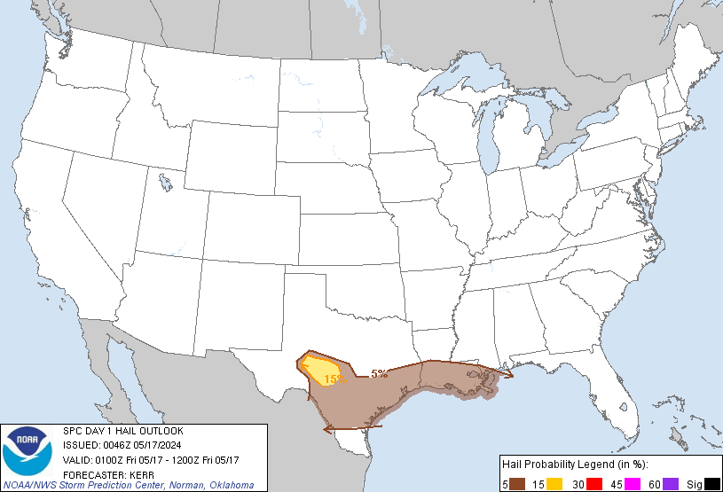
The Weather Prediction Center issues a Slight Risk for Excessive Rainfall across portions of SE Texas including Metro Houston in their updated Outlook for tomorrow.
- Attachments
-
Carla/Alicia/Jerry(In The Eye)/Michelle/Charley/Ivan/Dennis/Katrina/Rita/Wilma/Humberto/Ike/Harvey
Member: National Weather Association
Facebook.com/Weather Infinity
Twitter @WeatherInfinity
Member: National Weather Association
Facebook.com/Weather Infinity
Twitter @WeatherInfinity
lots of chasers out there
http://www.iweathernet.com/thunderstorm ... storm-cams
http://www.severestudios.com/livechase/
http://www.iweathernet.com/thunderstorm ... storm-cams
http://www.severestudios.com/livechase/

The SPC loop to follow the action

High CAPE, jest - awfully N-S are going to stay west at least. Hopefully, more of a heavy rain and flooding main issue than tornado, but mesos over performing.


High CAPE, jest - awfully N-S are going to stay west at least. Hopefully, more of a heavy rain and flooding main issue than tornado, but mesos over performing.
Last edited by DoctorMu on Sun Feb 19, 2017 9:38 pm, edited 1 time in total.
pretty wicked looking, busy night for TX Mets
http://weather.cod.edu/satrad/?type=TX- ... verDim=100
http://www.spc.ncep.noaa.gov/products/md/
http://www.wpc.ncep.noaa.gov/metwatch/metwatch_mpd.php
http://weather.cod.edu/satrad/?type=TX- ... verDim=100
http://www.spc.ncep.noaa.gov/products/md/
http://www.wpc.ncep.noaa.gov/metwatch/metwatch_mpd.php
Bow echo forming and taking aim at San Antonio.
Hail and flash flooding concerns.
Hail and flash flooding concerns.
Slight hail risk:
Last edited by DoctorMu on Sun Feb 19, 2017 9:35 pm, edited 3 times in total.
WUUS54 KEWX 200310
SVREWX
TXC325-200400-
/O.NEW.KEWX.SV.W.0022.170220T0310Z-170220T0400Z/
BULLETIN - IMMEDIATE BROADCAST REQUESTED
Severe Thunderstorm Warning
National Weather Service Austin/San Antonio TX
910 PM CST SUN FEB 19 2017
The National Weather Service in Austin San Antonio has issued a
* Severe Thunderstorm Warning for...
Southern Medina County in south central Texas...
* Until 1000 PM CST
* At 910 PM CST, a severe thunderstorm was located near Yancey, or 9
miles south of Hondo, moving east at 40 mph.
HAZARD...60 mph wind gusts and penny size hail.
SOURCE...Radar indicated.
IMPACT...Expect damage to roofs, siding, and trees.
* Locations impacted include...
Hondo, Devine, Castroville, Lytle, Natalia, Lacoste, Cliff,
D'Hanis, Noonan, New Fountain, Quihi, Dunlay, Biry, Pearson,
Yancey, Bader and Rio Medina.
PRECAUTIONARY/PREPAREDNESS ACTIONS...
Remain alert for a possible tornado! Tornadoes can develop quickly
from severe thunderstorms. If you spot a tornado go at once into the
basement or small central room in a sturdy structure.
For your protection move to an interior room on the lowest floor of a
building.
Torrential rainfall is occurring with this storm, and may lead to
flash flooding. Do not drive your vehicle through flooded roadways.
&&
LAT...LON 2909 9937 2929 9939 2953 9881 2917 9881
TIME...MOT...LOC 0310Z 253DEG 36KT 2922 9919
TORNADO...POSSIBLE
HAIL...0.75IN
WIND...60MPH
Well south and west. Fingers crossed things chill a bit overnight.
WFUS54 KCRP 200256
TORCRP
TXC131-479-200330-
/O.NEW.KCRP.TO.W.0005.170220T0256Z-170220T0330Z/
BULLETIN - EAS ACTIVATION REQUESTED
Tornado Warning
National Weather Service Corpus Christi TX
856 PM CST SUN FEB 19 2017
The National Weather Service in Corpus Christi has issued a
* Tornado Warning for...
Northwestern Duval County in south central Texas...
East central Webb County in south central Texas...
* Until 930 PM CST
* At 854 PM CST, a severe thunderstorm capable of producing a tornado
was located 13 miles east of Callaghan, or 17 miles southeast of
Encinal, moving east at 40 mph.
HAZARD...Tornado.
SOURCE...Radar indicated rotation.
IMPACT...Flying debris will be dangerous to those caught without
shelter. Mobile homes will be damaged or destroyed.
Damage to roofs, windows, and vehicles will occur. Tree
damage is likely.
* This tornadic thunderstorm will remain over mainly rural areas of
northwestern Duval and east central Webb Counties.
PRECAUTIONARY/PREPAREDNESS ACTIONS...
TAKE COVER NOW! Move to a basement or an interior room on the lowest
floor of a sturdy building. Avoid windows. If you are outdoors, in a
mobile home, or in a vehicle, move to the closest substantial shelter
and protect yourself from flying debris.
&&
LAT...LON 2774 9924 2788 9929 2805 9878 2778 9872
TIME...MOT...LOC 0254Z 257DEG 36KT 2784 9918
TORNADO...RADAR INDICATED
HAIL...<.75IN
MESOSCALE PRECIPITATION DISCUSSION 0059
NWS WEATHER PREDICTION CENTER COLLEGE PARK MD
915 PM EST SUN FEB 19 2017
AREAS AFFECTED...CENTRAL AND SOUTH TEXAS
CONCERNING...HEAVY RAINFALL...FLASH FLOODING POSSIBLE
VALID 200215Z - 200615Z
SUMMARY...STRONG THUNDERSTORMS ORGANIZING OVER PARTS OF CENTRAL
AND SOUTHERN TX AND THE RIO GRANDE VALLEY. HEAVY RAINS WILL RESULT
IN SOME FLASH FLOODING POTENTIAL.
DISCUSSION...AN EXPANDING N/S AREA OF ORGANIZED THUNDERSTORMS WITH
HEAVY RAINFALL RATES UPWARDS OF 2 INCHES/HR EXTENDS FROM CENTRAL
TX SOUTH DOWN TO THE RIO GRANDE RIVER AND INTO NORTHERN MEXICO.
THE BAND OF THUNDERSTORMS IS FORMING ALONG AND JUST AHEAD OF A
COLD FRONT AND WITHIN AN AREA OF QUITE DIFFLUENT FLOW ALOFT
ASSOCIATED WITH A 90+KT 250 MB JET LIFTING NORTH AROUND THE EAST
SIDE OF A STRONG UPPER VORT CENTER OVER NORTHERN MEXICO.
THE AIRMASS AHEAD OF THE BAND OF CONVECTION IS MODERATELY UNSTABLE
WITH MLCAPE VALUES OF 1500 TO 2500 J/KG. MEANWHILE...PWATS OF 1.2
TO 1.4 INCHES ARE NOTED WITH A DEEP SOUTHERLY FETCH OF MOISTURE
TRANSPORT NOTED AHEAD OF THE EJECTING UPPER TROUGH THAT EXTENDS
OVER THE SOUTHERN PLAINS AND INTO NORTHERN MEXICO.
THE HIRES MODEL GUIDANCE IS NOT HANDLING THE CONVECTIVE EVOLUTION
NEAR THE RIO GRANDE WELL...AS CONVECTION IS MUCH MORE ORGANIZED
THAN WHAT WAS FORECAST. THE LATEST IR SATELLITE IMAGERY SHOWS
COOLING CLOUDS WITH EMBEDDED OVERSHOOTING TOPS...ESPECIALLY IN
VICINITY OF KINNEY...MAVERICK...ZAVALA AND DIMMIT COUNTIES. ALSO
STRONG OVERSHOOTING TOPS ARE MOVING INTO WEBB COUNTY JUST OVER THE
RIO GRANDE RIVER.
THE CONVECTION SHOULD REMAIN ORGANIZED GIVEN THE LEVEL OF
INSTABILITY AND MOISTURE POOLED OVER SOUTH TX...WITH THE ACTIVITY
GRADUALLY BOWING OFF TO THE EAST OVER THE NEXT SEVERAL HOURS AS
THE UPPER TROUGH AXIS TO THE WEST GRADUALLY ADVANCES EAST.
EXPECT RAINFALL AMOUNTS OF 2 TO 4 INCHES TO BE POSSIBLE OVER JUST
A COUPLE OF HOURS...WHICH MAY RESULT IN SOME RUNOFF PROBLEMS AND
POSSIBLE FLASH FLOODING.
WUUS54 KEWX 200434
SVREWX
TXC029-091-187-493-200530-
/O.NEW.KEWX.SV.W.0023.170220T0434Z-170220T0530Z/
BULLETIN - IMMEDIATE BROADCAST REQUESTED
Severe Thunderstorm Warning
National Weather Service Austin/San Antonio TX
1034 PM CST SUN FEB 19 2017
The National Weather Service in Austin San Antonio has issued a
* Severe Thunderstorm Warning for...
Southwestern Guadalupe County in south central Texas...
Northwestern Wilson County in south central Texas...
Central Bexar County in south central Texas...
South central Comal County in south central Texas...
* Until 1130 PM CST
* At 1034 PM CST, severe thunderstorms were located along a line
extending from near San Antonio Int Ap to near Elmendorf, moving
northeast at 30 mph.
HAZARD...60 mph wind gusts and quarter size hail.
SOURCE...Radar indicated.
IMPACT...Hail damage to vehicles is expected. Expect wind damage
to roofs, siding, and trees.
* Locations impacted include...
San Antonio, New Braunfels, Schertz, Cibolo, Universal City, Live
Oak, Selma, San Antonio Int Ap, Stinson Municipal Airport, Randolph
AFB, Kirby, Alamo Heights, Windcrest, Canyon Lake, Terrell Hills,
Bulverde, Garden Ridge, Hollywood Park, Olmos Park and St. Hedwig.
BULLETIN - EAS ACTIVATION REQUESTED
Tornado Warning
National Weather Service Austin/San Antonio TX
1102 PM CST SUN FEB 19 2017
The National Weather Service in Austin San Antonio has issued a
* Tornado Warning for...
West central Guadalupe County in south central Texas...
Southeastern Comal County in south central Texas...
* Until 1145 PM CST
* At 1102 PM CST, severe thunderstorms capable of producing both
tornadoes and extensive straight line wind damage were located near
Garden Ridge, or near Selma, moving northeast at 35 mph.
HAZARD...Tornado.
SOURCE...Radar indicated rotation.
IMPACT...Flying debris will be dangerous to those caught without
shelter. Mobile homes will be damaged or destroyed.
Damage to roofs, windows, and vehicles will occur. Tree
damage is likely.
* Locations impacted include...
New Braunfels, Schertz, Cibolo, Garden Ridge, Santa Clara,
Freiheit, Solms, Gruene and New Braunfels Regional Airport.
PRECAUTIONARY/PREPAREDNESS ACTIONS...
TAKE COVER NOW! Move to a basement or an interior room on the lowest
floor of a sturdy building. Avoid windows. If you are outdoors, in a
mobile home, or in a vehicle, move to the closest substantial shelter
and protect yourself from flying debris.
Hope this cell chills...because the vector is towards Navasota, BCS area...

WFUS54 KEWX 200605
TOREWX
TXC021-453-200630-
/O.NEW.KEWX.TO.W.0007.170220T0605Z-170220T0630Z/
BULLETIN - EAS ACTIVATION REQUESTED
Tornado Warning
National Weather Service Austin/San Antonio TX
1205 AM CST MON FEB 20 2017
The National Weather Service in Austin San Antonio has issued a
* Tornado Warning for...
Northeastern Travis County in south central Texas...
North central Bastrop County in south central Texas...
* Until 1230 AM CST
* At 1205 AM CST, severe thunderstorms capable of producing both
tornadoes and extensive straight line wind damage were located near
Manor, or 7 miles northeast of Austin Bergstrom Int Ap, moving
northeast at 60 mph.
HAZARD...Tornado.
SOURCE...Radar indicated rotation.
IMPACT...Flying debris will be dangerous to those caught without
shelter. Mobile homes will be damaged or destroyed.
Damage to roofs, windows, and vehicles will occur. Tree
damage is likely.
* Locations impacted include...
Austin, Pflugerville, Elgin, Manor, Webberville, Cedar Hills and
Butler.
PRECAUTIONARY/PREPAREDNESS ACTIONS...
TAKE COVER NOW! Move to a basement or an interior room on the lowest
floor of a sturdy building. Avoid windows. If you are outdoors, in a
mobile home, or in a vehicle, move to the closest substantial shelter
and protect yourself from flying debris.
This cluster of thunderstorms is capable of producing tornadoes and
widespread significant wind damage. Do not wait to see or hear the
tornado. For your protection move to an interior room on the lowest
floor of a building.
Possible continuing event into the SE. Could be a long 24 hours ahead. MS in the bullseye yet again.
Storms should arrive in CLL area in about 1 hour. Under 2 hours for the worst of it.
Columbus should feel effects in about an hour. 2 hours to near Katy.
Area Forecast Discussion
National Weather Service Houston/Galveston TX
1127 PM CST Sun Feb 19 2017
.AVIATION...
Just minor tweaks for the 6z TAFs compared to the previous set.
Most fcsts were already updated for estimates as to when the
leading edge of storms currently in cntl will be moving into SE Tx
overnight. Moderate to heavy rain & perhaps 25-40kt gusts
expected along the initial boundary followed by several hours of
light to occasional moderate rainfall during the day Mon. Did
bring in some more favorable aviation conditions in the mid/late
afternoon hours. There`s a chance we fog up tomorrow night w/
light winds & wet grounds. 47
&&
.PREV DISCUSSION... /ISSUED 1006 PM CST Sun Feb 19 2017/
More models are jumping on board with the Texas Tech WRF in
showing a little earlier arrival of the approaching system
overnight tonight. Current thinking puts the onset of showers and
storms to around 1 to 4 am for the Brazos Valley down to Matagorda
Bay, 3 to 6 am for the Houston metro, and 5 to 8 am for Liberty
County and around Galveston Bay. Of course, this is just the
onset, and showers and storms will likely impact SE Texas for much
of the day tomorrow. Some models including the HRRR are
suggesting the formation of a surface boundary which could be a
focus for training storms and heavier rainfall. Confidence on
where this boundary ends up focusing the heaviest rainfall is low.
A Flash Flood Watch remains in effect for much of SE Texas from 3
am to 4 pm. 11/47
WFUS54 KEWX 200623
TOREWX
TXC491-200645-
/O.NEW.KEWX.TO.W.0008.170220T0623Z-170220T0645Z/
BULLETIN - EAS ACTIVATION REQUESTED
Tornado Warning
National Weather Service Austin/San Antonio TX
1223 AM CST MON FEB 20 2017
The National Weather Service in Austin San Antonio has issued a
* Tornado Warning for...
Southeastern Williamson County in south central Texas...
* Until 1245 AM CST
* At 1223 AM CST, a severe thunderstorm capable of producing a
tornado was located near Taylor, moving east at 30 mph.
HAZARD...Tornado.
SOURCE...Radar indicated rotation.
IMPACT...Flying debris will be dangerous to those caught without
shelter. Mobile homes will be damaged or destroyed.
Damage to roofs, windows, and vehicles will occur. Tree
damage is likely.
* Locations impacted include...
Taylor, Thrall, Coupland, Granger Dam, Laneport, Noack, Hoxie,
Beyarsville, Waterloo, Hare and Sandoval.
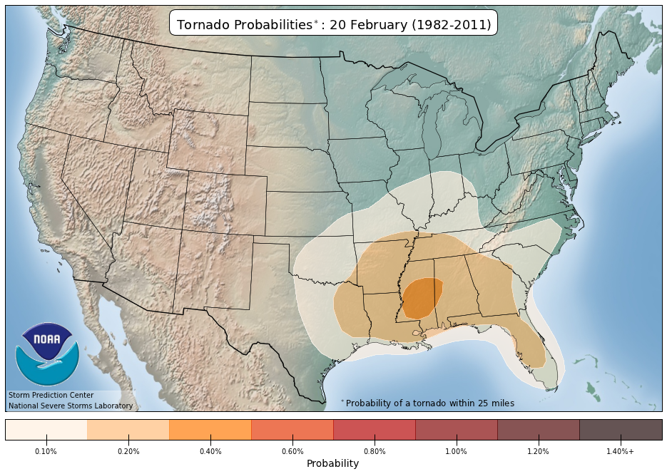
that probability map is based on climo, not current weather - from the site:
http://www.spc.ncep.noaa.gov/new/SVRcli ... rm=allTorn
*These probability values were estimated from a 30-year period of severe weather reports from 1982-2011. The procedure to create the maps is as follows:
1. Reports for each day are put onto a grid 80 km x 80 km.
2. If one or more reports occur in a grid box, that box is assigned the value "1" for the day. If no reports occur, it's a zero.
3. The raw frequency for each day at each grid location is found for the period (number of "1" values divided by number of years) to get a raw annual cycle.
4. The raw annual cycle at each point is smoothed in time, using a Gaussian filter with a standard deviation of 15 days.
5. The smoothed time series are then smoothed in space with a 2-D Gaussian filter (SD = 120 km in each direction).
DoctorMu wrote:Possible continuing event into the SE. Could be a long 24 hours ahead. MS in the bullseye yet again.
you can find tweets from NWS Southern Region offices on one page here, compliments of Corey Pieper
https://twitter.com/Geostrophic/lists/n ... ern-region
https://twitter.com/Geostrophic/lists/n ... ern-region