
February 2017- Spring Like Weather Returns
-
srainhoutx

- Site Admin

- Posts: 19616
- Joined: Tue Feb 02, 2010 2:32 pm
- Location: Maggie Valley, NC
- Contact:
Saturday morning briefing from Jeff:
Powerful California storm system will arrive into TX Sunday.
Parameters will come together over the next 48 hours to produce a round of strong to possibly severe thunderstorms with a heavy rainfall threat. Upper level system that brought the flooding rainfall to southern California on Friday will progress into N MX today and then begin to enter W TX on Sunday. Strong low level jet axis will increase tonight allowing very high moisture levels to spread inland across TX from the southern Gulf of Mexico while additional mid and high level moisture arrives from the eastern Pacific. Area will be capped for most of Sunday with only a few light south to north moving showers expected, but capping will be along the I-35 corridor by mid to late afternoon as strong ascent arrives from the west and overspreads the deep moisture axis. Forecast soundings show varying degrees of CAPE (instability) across the I-35 corridor yielding varying solutions on how rapidly storms begin to evolve. Moisture profiles rise Sunday evening into Monday morning into a very respectable 1.5-1.8 inches over SE TX with that upper values near/at maximum record levels for this time of year.
Expect widespread showers and thunderstorms to develop Sunday afternoon over C TX and spread into SE TX Sunday night into Monday morning. Latest Texas Tech WRF is fairly progressive with this line of storms, but other models are not as fast. Position of the upper level low and uni-directional shear values support a slower progression of this line and also the potential for repeat cell training across SE TX especially on Monday morning. High moisture values are concerning especially given the potential convective nature which may yield high hourly rainfall rates of 2-3 inches. One aspect that does appear to be missing is any sort of defined slow moving surface boundary to help focus and anchor convection.
Overall expect rainfall amounts from Sunday evening to Monday evening to average 2-3 inches with isolated totals of 5-6 inches possible. These higher totals will only be realized under areas of cell training and virtually the entire region is at risk.
Over SE TX the severe threat looks marginal at this time
Carla/Alicia/Jerry(In The Eye)/Michelle/Charley/Ivan/Dennis/Katrina/Rita/Wilma/Humberto/Ike/Harvey
Member: National Weather Association
Facebook.com/Weather Infinity
Twitter @WeatherInfinity
Member: National Weather Association
Facebook.com/Weather Infinity
Twitter @WeatherInfinity
-
brooksgarner

- Global Moderator

- Posts: 226
- Joined: Tue Jun 04, 2013 3:06 pm
- Location: Houston, TX
- Contact:
Hi Steve,
Thanks for posting your thoughts. Heck of a California storm. My bro is in LA and has said it's pretty real.
For Houston, I agree that the system looks consistently progressive and the 2-3"/hr for 6-12 hours scenario and big flooding does not look likely this go around. This is a divergence from earlier, wetter model runs this week...
Interesting to note one, "change" to be on the lookout for is if that low to become inverted about 60-100 miles farther west than currently forecast/advertised by the models, pushing that flooding-favorable upper wind axis/trough over Houston instead of over Beaumont and western Louisiana. That'd give us a few more hours of the intense rain, instead of just a 1-2hr downpour. (Sabine River region could easily see 5-7" as it currently stands, compared to Houston's 1.5"-4".)
Finally, CAPE values look to hovering around 700-1,000 J/kg for Houston during time of heaviest rain in the morning, with PWATS approaching 2". That'll be a burst of rain and gusts to 40mph, but with no jet streak over about 80 knots, any twisters would be brief/weak.
As of Saturday afternoon, I'm giving it just a 30% chance of being a BIG deal for Houston with big floods. I'm giving it a 60% chance that we'll see some severe weather (brief, weak tornadoes, and/or straight-line winds to 50mph) -- but a 70% chance it'll be just be a common, stormy Monday morning with nothing historically notable.
That said, potential is there so we're doing team coverage (myself with KHOU forum vet, Blake Mathews) Monday morning starting at 4:30am, in case anything changes. This is weather, after all, so we humans can only speculate. Nature decides! See you there!
-Brooks
Broadcast Met
http://BrooksGarner.com
http://twitter.com/BrooksWeather
http://BrooksGarner.com
http://twitter.com/BrooksWeather
- '17 Harvey
- '12 Sandy (P3 Orion)
- '91 Bob
- '85 Gloria
-
srainhoutx
- Site Admin
- Posts: 19616
- Joined: Tue Feb 02, 2010 2:32 pm
- Location: Maggie Valley, NC
- Contact:
Thanks for sharing your thoughts, Brooks. I did notice a slight slowing with the 500mb upper low and a bit of a shift West with the heaviest rainfall axis. The WPC/HPC afternoon updated quantitative precipitation forecast has indeed shifted somewhat West placing SE Texas in the higher rainfall totals. I also noticed the PW's are very near the 2 inch mark which is unusually high for late February in our part of the World.
- Attachments
-
Carla/Alicia/Jerry(In The Eye)/Michelle/Charley/Ivan/Dennis/Katrina/Rita/Wilma/Humberto/Ike/Harvey
Member: National Weather Association
Facebook.com/Weather Infinity
Twitter @WeatherInfinity
Member: National Weather Association
Facebook.com/Weather Infinity
Twitter @WeatherInfinity
-
brooksgarner
- Global Moderator
- Posts: 226
- Joined: Tue Jun 04, 2013 3:06 pm
- Location: Houston, TX
- Contact:
It'll be a watcher. The RPM's been pretty progressive on the latest runs. EURO also pretty fast. All it takes is that upper ridge to strengthen ever so slightly over FL and the Yucatan Peninsula to slow it all down... Of course, even then, if a meso cold pool develops behind the line, it'll push east before hanging up. Chaos.... 
Broadcast Met
http://BrooksGarner.com
http://twitter.com/BrooksWeather
http://BrooksGarner.com
http://twitter.com/BrooksWeather
- '17 Harvey
- '12 Sandy (P3 Orion)
- '91 Bob
- '85 Gloria
Maybe im misreading things but it looks like the 18z model runs keep the rain around longer and have shifted the higher accumulations back towards the central and eastern part of the area. The Texas Tech WRF has the leading line move through early morning but keeps rain over the area until late afternoon/evening.
-
srainhoutx
- Site Admin
- Posts: 19616
- Joined: Tue Feb 02, 2010 2:32 pm
- Location: Maggie Valley, NC
- Contact:
The Weather Prediction Center issues a Slight Risk for Excessive Rainfall along portions of the Middle Texas Coast in the Day 1 Outlook surrounded by a Marginal Risk for our Western and South Western areas of SE Texas. All of SE Texas is in a Marginal Risk for Excessive Rainfall tomorrow, but that may change as additional data becomes available throughout the day into the overnight hours. Expect a lot of changes in the complicated and challenging forecast. Some of the shorter term overnight guidance have trended less progressive with the Storm System and keep the Heavy Rainfall threat going throughout much of Monday. Stay weather aware the next 12 to 24 hours in the very changeable forecast situation.
- Attachments
-
-
Carla/Alicia/Jerry(In The Eye)/Michelle/Charley/Ivan/Dennis/Katrina/Rita/Wilma/Humberto/Ike/Harvey
Member: National Weather Association
Facebook.com/Weather Infinity
Twitter @WeatherInfinity
Member: National Weather Association
Facebook.com/Weather Infinity
Twitter @WeatherInfinity
-
srainhoutx
- Site Admin
- Posts: 19616
- Joined: Tue Feb 02, 2010 2:32 pm
- Location: Maggie Valley, NC
- Contact:
Sunday morning briefing from Jeff:
A strong storm system will approach and move across TX today and Monday.
Moisture is on the increase this morning, but strong capping in the mid levels should preclude the development of showers and thunderstorms until late afternoon along I-35 and overnight across SE TX. Latest model guidance continues to be in decent agreement on the progression of this storm system across SE TX in the morning hours on Monday with lingering rainfall into the afternoon hours. Rapid advection of moisture into the area early this evening will help to moisten the air mass and models continue to point toward near record values of PWS of around 1.80 inches on Monday morning.
Deep convection will develop over SW TX late this afternoon and spread eastward in clusters/lines into C TX this evening and SE TX overnight. Have noticed some of the most recent models pushing an outflow boundary out ahead of the main line which then slows down across the eastern portions of SE TX late Monday morning. This is likely an indication of a well defined cold pool outrunning the main dynamics associated with the upper level system. It remains in question just how fast the main line may cross the area and if it could potentially slow down especially along and east of I-45.
Overall rainfall amounts of 1-3 inches will be common with isolated totals of 3-5 inches. Given the saturated moisture profiles for Monday morning combined with the threat for cell training does suggest high hourly rainfall rates of 1-2 inches in an hour which can result in rapid onset flash flood in urban areas. It is possible that the heaviest rainfall may impact the morning rush hour across the Houston metro area. With the upper level system remain to our west into late Monday moisture will be brought up and over the top of the surface cool pool so expect showers and maybe even a few thunderstorms to continue into Monday afternoon and evening.
As for the severe weather threat…the air mass looks only modestly unstable on Monday morning given the time of day and about 700-900 J/kg of CAPE. Wind energy aloft is not overly impressive and mainly from the south and southwest with little turning resulting in marginal shear values. This supports more of a heavy rainfall threat than a severe threat. However cannot rule out some gusty winds or even an isolated tornado with the line of storms and SPC has the western half of SE TX in a marginal (1 out of 5 risk) category.
Flash Flooding Risk:
Forecasted Rainfall Totals (Monday):
Severe Weather Outlook (Today into Monday):
[/i]
A strong storm system will approach and move across TX today and Monday.
Moisture is on the increase this morning, but strong capping in the mid levels should preclude the development of showers and thunderstorms until late afternoon along I-35 and overnight across SE TX. Latest model guidance continues to be in decent agreement on the progression of this storm system across SE TX in the morning hours on Monday with lingering rainfall into the afternoon hours. Rapid advection of moisture into the area early this evening will help to moisten the air mass and models continue to point toward near record values of PWS of around 1.80 inches on Monday morning.
Deep convection will develop over SW TX late this afternoon and spread eastward in clusters/lines into C TX this evening and SE TX overnight. Have noticed some of the most recent models pushing an outflow boundary out ahead of the main line which then slows down across the eastern portions of SE TX late Monday morning. This is likely an indication of a well defined cold pool outrunning the main dynamics associated with the upper level system. It remains in question just how fast the main line may cross the area and if it could potentially slow down especially along and east of I-45.
Overall rainfall amounts of 1-3 inches will be common with isolated totals of 3-5 inches. Given the saturated moisture profiles for Monday morning combined with the threat for cell training does suggest high hourly rainfall rates of 1-2 inches in an hour which can result in rapid onset flash flood in urban areas. It is possible that the heaviest rainfall may impact the morning rush hour across the Houston metro area. With the upper level system remain to our west into late Monday moisture will be brought up and over the top of the surface cool pool so expect showers and maybe even a few thunderstorms to continue into Monday afternoon and evening.
As for the severe weather threat…the air mass looks only modestly unstable on Monday morning given the time of day and about 700-900 J/kg of CAPE. Wind energy aloft is not overly impressive and mainly from the south and southwest with little turning resulting in marginal shear values. This supports more of a heavy rainfall threat than a severe threat. However cannot rule out some gusty winds or even an isolated tornado with the line of storms and SPC has the western half of SE TX in a marginal (1 out of 5 risk) category.
Flash Flooding Risk:
Carla/Alicia/Jerry(In The Eye)/Michelle/Charley/Ivan/Dennis/Katrina/Rita/Wilma/Humberto/Ike/Harvey
Member: National Weather Association
Facebook.com/Weather Infinity
Twitter @WeatherInfinity
Member: National Weather Association
Facebook.com/Weather Infinity
Twitter @WeatherInfinity

PREV DISCUSSION... /ISSUED 1059 AM CST Sun Feb 19 2017/
DISCUSSION...
Seeing a few patches of drizzle still around late this morning.
Otherwise, no showers yet. With some heating, we are likely to
see isolated showers develop later this aft, especially across nw
areas. Removed the mention of thunder for this aft. Temps are
likely to peak close to 80 inland today with mostly cloudy skies.
The main event will begin after midnight as showers/thunderstorms
approach and/or develop across western areas. Expecting widespread
shwrs/tstms slowly moving from west to east in the 2 AM Mon to
late afternoon period. Looking like there will be a flash flood
threat where we see repeated cell movement over the same areas,
especially across the SE 2/3rds of the area. We are likely going
to be issuing a flash flood watch for portions of SE Texas later
this afternoon for the time period of early Monday morning through
Monday afternoon.
PREV DISCUSSION... /ISSUED 351 AM CST Sun Feb 19 2017/
DISCUSSION...
Patchy fog and low clouds prevail early this morning. The fog is
expected to dissipate by mid morning but skies will remain
generally cloudy through the day. Could be a light sprinkle or
some drizzle this morning beneath a strong capping inversion. 850
temps remain very warm and considering the warm start to the day,
it won`t take much heating to boost high temps to 80. Limiting
factors would be the cloud cover and stronger winds. Trimmed PoPs
for today as ascent from the approaching upper trough won`t arrive
until tonight and fcst soundings show relatively dry moisture
profiles and a capping inversion in place for most of the day.
Moisture increase rapidly tonight as an upper level trough
approaches West Texas. PW values reach 1.5-1.6 inches by 09z and
1.80 inches by 12z. Fcst soundings show a saturated profile from
the sfc to 500 mb at 12z over the central/coastal zones. The GFS
dries things out over the west with very dry air moving into the
900-700 mb layer at 12z which considering the dynamics and
orientation of the moisture axis, well, it looks weird. The GFS
fcst soundings tries to dry things out quickly on Monday but with
the upper level trough axis to the west, shra/tsra likely to
persist into the mid afternoon before drying commences. The TT WRF
which performed very well on Friday maintains rain all day
Monday. Upper level winds still look very favorable as SE TX will
lie in a splitting jet at 300 mb and will also lie in a weak jet
couplet. Have added locally heavy rain to the weather grids. At
this time, it appears widespread rainfall of 1 to 2 inches with
isolated totals between 3 and 5 inches will fall across the area.
SPC has placed the western half of SE TX in a marginal risk for
severe weather for late tonight. Could get some gusty winds and
small hail but it appears the primary hazard will be heavy rain.
Drier air will work into the region Mon night and Tuesday as weak
high pressure moves into the state behind the departing upper
trough. Temperatures will remain unseasonably warm with highs in
the mid/upper 70s. Unseasonably warm temps will prevail for much
of next week as 850 temps stay warm. The air mass will be dry so
there should be a relatively large diurnal range each day. Low
pressure will develop in the lee of the Rockies on Thursday and
this system will move northeast and drag a cold front across SE TX
Friday evening. Might have enough moisture to squeeze out a
shower or two but will keep the fcst dry for now. Temps will trend
cooler next Saturday in the wake of the front. Warm air advection
next Sunday will bring a few showers and slightly warmer temps
back to the area.
-
Katdaddy

- Global Moderator
- Posts: 2502
- Joined: Thu Feb 04, 2010 8:18 am
- Location: League City, Tx
- Contact:
...FLASH FLOOD WATCH IN EFFECT FROM LATE TONIGHT THROUGH MONDAY
AFTERNOON...
The National Weather Service in Houston/Galveston has issued a
* Flash Flood Watch for portions of Southeast Texas...including
the following counties...Jackson. In southeast Texas...Austin...
Brazoria...Brazos...Burleson...Chambers...Colorado...Fort Bend...
Galveston...Grimes...Harris...Liberty...Madison...Matagorda...
Montgomery...San Jacinto...Walker...Waller...Washington and Wharton.
* From late tonight through Monday afternoon
* The combination of an approaching upper level storm system from
the west and well above normal moisture levels will set the
stage for widespread thunderstorm development with locally heavy
rainfall. The flash flood threat will begin across western
portions of southeast Texas during the early morning hours and
will slowly progress eastward during the day. Rainfall amounts
are expected to average between 1 to 3 inches across the watch
area with localized areas expected to receive between 4 and 6
inches of rainfall. These localized rainfall amounts when coupled
with wet soils from previous rainfall would lead to flash flooding.
* Street flooding and flooding of low lying areas are the most
likely impacts tonight and Monday. Small streams and bayous may
be impacted during the day on Monday.
PRECAUTIONARY/PREPAREDNESS ACTIONS...
A Flash Flood Watch means that conditions may develop that lead
to flash flooding. Flash flooding is a very dangerous situation.
You should monitor later forecasts and be prepared to take action
should Flash Flood Warnings be issued.
- Attachments
-
- Screen Shot 2017-02-19 at 2.05.35 PM.png (23.47 KiB) Viewed 5112 times
-
srainhoutx
- Site Admin
- Posts: 19616
- Joined: Tue Feb 02, 2010 2:32 pm
- Location: Maggie Valley, NC
- Contact:
The Weather Prediction Center issues a Slight Risk for Excessive Rainfall across portions of SE Texas including Metro Houston in their updated Outlook for tomorrow.
- Attachments
-
Carla/Alicia/Jerry(In The Eye)/Michelle/Charley/Ivan/Dennis/Katrina/Rita/Wilma/Humberto/Ike/Harvey
Member: National Weather Association
Facebook.com/Weather Infinity
Twitter @WeatherInfinity
Member: National Weather Association
Facebook.com/Weather Infinity
Twitter @WeatherInfinity
lots of chasers out there
http://www.iweathernet.com/thunderstorm ... storm-cams
http://www.severestudios.com/livechase/
http://www.iweathernet.com/thunderstorm ... storm-cams
http://www.severestudios.com/livechase/
The SPC loop to follow the action

High CAPE, jest - awfully N-S are going to stay west at least. Hopefully, more of a heavy rain and flooding main issue than tornado, but mesos over performing.


High CAPE, jest - awfully N-S are going to stay west at least. Hopefully, more of a heavy rain and flooding main issue than tornado, but mesos over performing.
Last edited by DoctorMu on Sun Feb 19, 2017 9:38 pm, edited 1 time in total.
pretty wicked looking, busy night for TX Mets
http://weather.cod.edu/satrad/?type=TX- ... verDim=100
http://www.spc.ncep.noaa.gov/products/md/
http://www.wpc.ncep.noaa.gov/metwatch/metwatch_mpd.php
http://weather.cod.edu/satrad/?type=TX- ... verDim=100
http://www.spc.ncep.noaa.gov/products/md/
http://www.wpc.ncep.noaa.gov/metwatch/metwatch_mpd.php
Bow echo forming and taking aim at San Antonio.
Hail and flash flooding concerns.
Hail and flash flooding concerns.
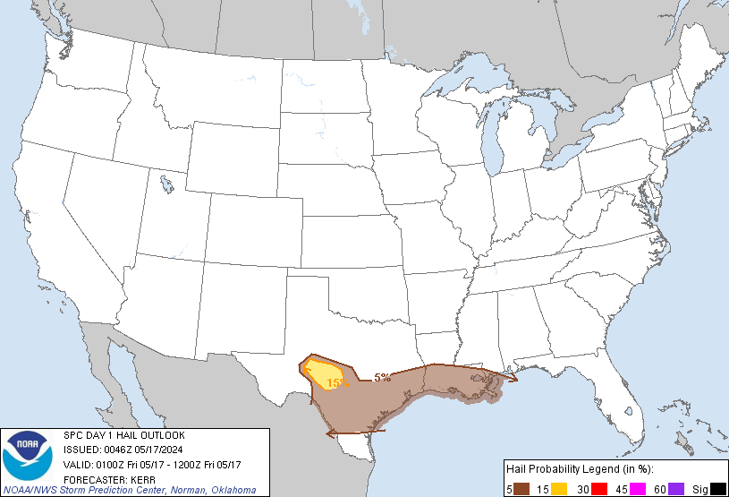
Slight hail risk:
Last edited by DoctorMu on Sun Feb 19, 2017 9:35 pm, edited 3 times in total.
WUUS54 KEWX 200310
SVREWX
TXC325-200400-
/O.NEW.KEWX.SV.W.0022.170220T0310Z-170220T0400Z/
BULLETIN - IMMEDIATE BROADCAST REQUESTED
Severe Thunderstorm Warning
National Weather Service Austin/San Antonio TX
910 PM CST SUN FEB 19 2017
The National Weather Service in Austin San Antonio has issued a
* Severe Thunderstorm Warning for...
Southern Medina County in south central Texas...
* Until 1000 PM CST
* At 910 PM CST, a severe thunderstorm was located near Yancey, or 9
miles south of Hondo, moving east at 40 mph.
HAZARD...60 mph wind gusts and penny size hail.
SOURCE...Radar indicated.
IMPACT...Expect damage to roofs, siding, and trees.
* Locations impacted include...
Hondo, Devine, Castroville, Lytle, Natalia, Lacoste, Cliff,
D'Hanis, Noonan, New Fountain, Quihi, Dunlay, Biry, Pearson,
Yancey, Bader and Rio Medina.
PRECAUTIONARY/PREPAREDNESS ACTIONS...
Remain alert for a possible tornado! Tornadoes can develop quickly
from severe thunderstorms. If you spot a tornado go at once into the
basement or small central room in a sturdy structure.
For your protection move to an interior room on the lowest floor of a
building.
Torrential rainfall is occurring with this storm, and may lead to
flash flooding. Do not drive your vehicle through flooded roadways.
&&
LAT...LON 2909 9937 2929 9939 2953 9881 2917 9881
TIME...MOT...LOC 0310Z 253DEG 36KT 2922 9919
TORNADO...POSSIBLE
HAIL...0.75IN
WIND...60MPH
Well south and west. Fingers crossed things chill a bit overnight.
WFUS54 KCRP 200256
TORCRP
TXC131-479-200330-
/O.NEW.KCRP.TO.W.0005.170220T0256Z-170220T0330Z/
BULLETIN - EAS ACTIVATION REQUESTED
Tornado Warning
National Weather Service Corpus Christi TX
856 PM CST SUN FEB 19 2017
The National Weather Service in Corpus Christi has issued a
* Tornado Warning for...
Northwestern Duval County in south central Texas...
East central Webb County in south central Texas...
* Until 930 PM CST
* At 854 PM CST, a severe thunderstorm capable of producing a tornado
was located 13 miles east of Callaghan, or 17 miles southeast of
Encinal, moving east at 40 mph.
HAZARD...Tornado.
SOURCE...Radar indicated rotation.
IMPACT...Flying debris will be dangerous to those caught without
shelter. Mobile homes will be damaged or destroyed.
Damage to roofs, windows, and vehicles will occur. Tree
damage is likely.
* This tornadic thunderstorm will remain over mainly rural areas of
northwestern Duval and east central Webb Counties.
PRECAUTIONARY/PREPAREDNESS ACTIONS...
TAKE COVER NOW! Move to a basement or an interior room on the lowest
floor of a sturdy building. Avoid windows. If you are outdoors, in a
mobile home, or in a vehicle, move to the closest substantial shelter
and protect yourself from flying debris.
&&
LAT...LON 2774 9924 2788 9929 2805 9878 2778 9872
TIME...MOT...LOC 0254Z 257DEG 36KT 2784 9918
TORNADO...RADAR INDICATED
HAIL...<.75IN