
Unconvential delivery of cold air, but i'll take it.
I still think we could see a few pellets or flakes this week on the backside of the rain.
December 2016- End Of Year Forecast
-
MontgomeryCoWx

- Posts: 2356
- Joined: Wed Dec 14, 2011 4:31 pm
- Location: Weimar, TX
- Contact:
Team #NeverSummer
-
MontgomeryCoWx
- Posts: 2356
- Joined: Wed Dec 14, 2011 4:31 pm
- Location: Weimar, TX
- Contact:
By the way, the Euro trend is from a cold few days to cold as **** couple days followed by some more cold days.
Team #NeverSummer
Hypothetically speaking, if the setup for this weekend had an additional feature of temperatures being in the 80's, would we be talking more rain? Seems like a lot of the players are in place, similar to last April and May's rain event.
Thanks.
Thanks.
-
srainhoutx

- Site Admin

- Posts: 19616
- Joined: Tue Feb 02, 2010 2:32 pm
- Location: Maggie Valley, NC
- Contact:
The afternoon updated quantitative precipitation forecast for the next 3 days has increased. Careful driving around this weekend.
- Attachments
-
Carla/Alicia/Jerry(In The Eye)/Michelle/Charley/Ivan/Dennis/Katrina/Rita/Wilma/Humberto/Ike/Harvey
Member: National Weather Association
Facebook.com/Weather Infinity
Twitter @WeatherInfinity
Member: National Weather Association
Facebook.com/Weather Infinity
Twitter @WeatherInfinity
it looks like days 4-7 have little to no precip forecast in our area now - we've had only light mist so far - it will be interesting to see how this verifies after it's all blown through http://www.wpc.ncep.noaa.gov/verificati ... age=page-1srainhoutx wrote:The afternoon updated quantitative precipitation forecast for the next 3 days has increased. Careful driving around this weekend.

Looks like they just made a minor adjustment, just below 10" maximums.
-
MontgomeryCoWx
- Posts: 2356
- Joined: Wed Dec 14, 2011 4:31 pm
- Location: Weimar, TX
- Contact:
For those of us worried about a mild flip into Christmas... I don't believe we will be seeing that per the long range ensembles.
Team #NeverSummer
So to be clear, the Houston area is expecting up to 10 inches of rain over a 3 day period of time? Not a flooding situation like this past spring, right?
Thank you for all you do to keep us informed and safe!
Thank you for all you do to keep us informed and safe!

I'm hearing that it may rain this weekend?

-
christinac2016

- Posts: 115
- Joined: Thu Dec 01, 2016 3:18 pm
- Location: The Woodlands
- Contact:
I've noticed the timing of the start of the rain keeps getting pushed back. Just checked weather.com and now it's around 10. Going to do my shopping tonight so I don't have to get out in it tomorrow. Cold, rainy and Christmas music. Ahhh!
-
srainhoutx
- Site Admin
- Posts: 19616
- Joined: Tue Feb 02, 2010 2:32 pm
- Location: Maggie Valley, NC
- Contact:
Remember we received 15 to 20 inches in about 12 hours last April. This storm system is coming in waves over the next 60 hours or so.
Austin will see rainfall as well, but likely not as much as SE Texas. Hopefully that answered your questions and eased your minds a bit.
Austin will see rainfall as well, but likely not as much as SE Texas. Hopefully that answered your questions and eased your minds a bit.
Carla/Alicia/Jerry(In The Eye)/Michelle/Charley/Ivan/Dennis/Katrina/Rita/Wilma/Humberto/Ike/Harvey
Member: National Weather Association
Facebook.com/Weather Infinity
Twitter @WeatherInfinity
Member: National Weather Association
Facebook.com/Weather Infinity
Twitter @WeatherInfinity
-
srainhoutx
- Site Admin
- Posts: 19616
- Joined: Tue Feb 02, 2010 2:32 pm
- Location: Maggie Valley, NC
- Contact:
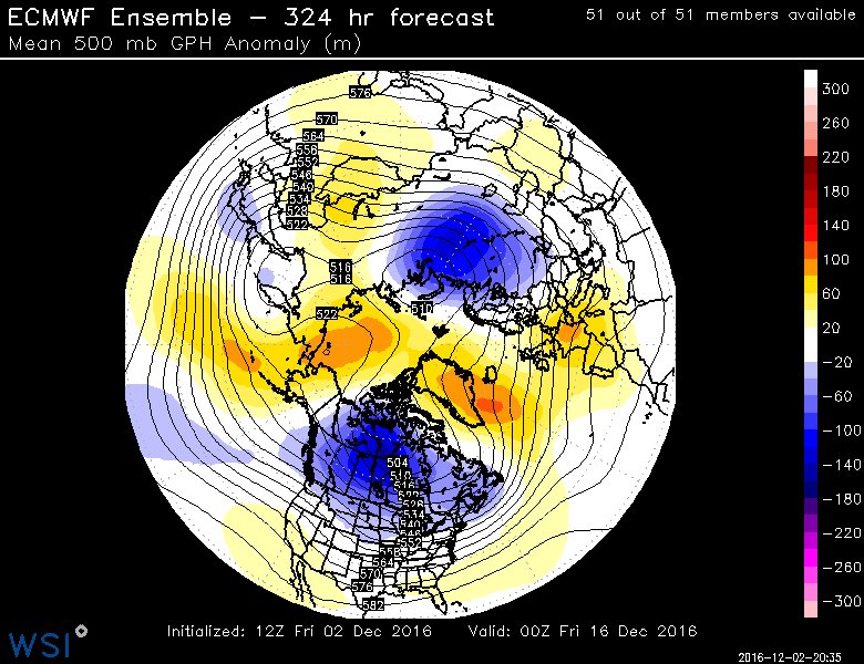
Classic split of the Polar Vortex, if that very long range ECMWF is correct. That Vortex has been anchored from the North Pole towards Siberia of late. What this model is showing is the very strong Arctic High over the Bering Sea and Western Alaska will break the Vortex into two pieces at the Tropospheric level.MontgomeryCoWx wrote:For those of us worried about a mild flip into Christmas... I don't believe we will be seeing that per the long range ensembles.
Carla/Alicia/Jerry(In The Eye)/Michelle/Charley/Ivan/Dennis/Katrina/Rita/Wilma/Humberto/Ike/Harvey
Member: National Weather Association
Facebook.com/Weather Infinity
Twitter @WeatherInfinity
Member: National Weather Association
Facebook.com/Weather Infinity
Twitter @WeatherInfinity
-
MontgomeryCoWx
- Posts: 2356
- Joined: Wed Dec 14, 2011 4:31 pm
- Location: Weimar, TX
- Contact:
Give me some 1983 blockingsrainhoutx wrote:Classic split of the Polar Vortex, if that very long range ECMWF is correct. That Vortex has been anchored from the North Pole towards Siberia of late. What this model is showing is the very strong Arctic High over the Bering Sea and Western Alaska will break the Vortex into two pieces at the Tropospheric level.MontgomeryCoWx wrote:For those of us worried about a mild flip into Christmas... I don't believe we will be seeing that per the long range ensembles.
Team #NeverSummer
-
Texaspirate11

- Posts: 1278
- Joined: Tue Dec 31, 2013 12:24 am
- Contact:
Nice downpour by the bay with that wind just gusting...brrrr. I'm over winter now.
The worse rain is, so far, off Galveston...
The worse rain is, so far, off Galveston...
Just because you're disabled, you don't have to be a victim
Be Weather Aware & Prepared!
Barbara Jordan Winner in Media
Disability Integration Consultant
Be Weather Aware & Prepared!
Barbara Jordan Winner in Media
Disability Integration Consultant
-
BlueJay
- Posts: 938
- Joined: Tue Mar 04, 2014 10:47 am
- Location: Alden Bridge-The Woodlands, Texas
- Contact:
srainhoutx wrote:Remember we received 15 to 20 inches in about 12 hours last April. This storm system is coming in waves over the next 60 hours or so.
Austin will see rainfall as well, but likely not as much as SE Texas. Hopefully that answered your questions and eased your minds a bit.
Thanks srain!
The NAM paints a LOT of rain in a band roughly along US-59 between now and Monday.
-
Andrew
- Site Admin
- Posts: 3440
- Joined: Wed Feb 03, 2010 9:46 pm
- Location: North-West Houston
- Contact:
Here are the bullet points for the next week or so:
Short term:
Short term:
- 1. 3-6 inches are expected across the region from tonight to Monday afternoon. Isolated totals of 10+ inches look possible.
2. Rain should spread-out over these three days which should reduce the flooding risk, but flash flooding still remains possible, especially Sunday.
3. All this rain is due to multiple coastal lows originating over the southwest gulf that will track towards the northeast. A coastal trough will also setup along the southern half of SE Texas with a southwest to northeast orientation. Finally, a mid level cutoff low will slowly move across Texas late afternoon as it shears out. Combine all these things and you get a classic multiple day heavy rain event.
4. Some disagreement on where the heavier/heaviest rain will setup and we won't know that for sure until we see where banding occurs.
- 1. An artic front is expected to move through SE Texas Wednesday Night. Depending on how much return flow occurs, dewpoints could drop from the upper 50s & low 60s to the 30s and 20s by Thursday morning.
2. It is looking more and more likely that most of SE Texas will see the first freeze of the year (yes, even the coastal counties could see one).
3. Exact low temperatures are still unknown but anywhere from the mid 20s to lower 30s look possible.
4. Models (especially the GFS) will continue to have trouble with how far south and how fast the cold air moves before it tracks east. Don't be fooled by the day to day changes. Keep an eye on the trends.
For Your Infinite Source For All Things Weather Visit Our Facebook
-
srainhoutx
- Site Admin
- Posts: 19616
- Joined: Tue Feb 02, 2010 2:32 pm
- Location: Maggie Valley, NC
- Contact:
Friday evening briefing from Jeff:
Heavy rainfall event likely this weekend which may lead to flooding
Discussion:
Coastal trough is forming off the upper TX coast with scattered showers advancing inland across much of SE TX this evening. Will see a gradual increase in coverage and intensity of rainfall tonight into Saturday with deeper convection and increasing rainfall rates. Radar trends over the Rio Grande plains currently starting to show an increase in returns and some sort of disturbance may be moving out of MX toward TX currently. Short terms models showing some potential for banding and cell training over the area within this extremely moist air mass. Coastal front will back inland starting Saturday with heavier convection likely along this feature and then the meso models show it waffling back and forth over the area into Sunday ahead of the main upper level system.
Point is that heavy rainfall and flooding will be possible from Saturday into Monday.
Rainfall Amounts:
Rainfall amounts have continued to increase today with widespread totals of 5-7 inches or more and isolated amounts of 8-10 inches possible. Should these amounts be realized flooding would be possible, but much of the run-off will be determined on just how fast the rain falls. Think tonight into Saturday will feature modest hourly totals with breaks between batches/bands giving the dry ground time to absorb the rainfall. The concern is Sunday onward when rainfall rates look to increase and the grounds become increasing saturated. Run-off will be maximized by Sunday and this appears to be the favored time when jet stream dynamics when be their strongest favoring higher hourly rainfall rates.
Prolonged nature of the event points toward our northern and western creeks, the San Jacinto system, Cedar Bayou, and Clear Creek as potential issues given that these watersheds take time to drain and prolonged rainfall will gradually add more and more water to these basins. The urban bayous….White Oak, Brays, Buffalo tend to be more vulnerable to the high intensity short duration rainfall rates instead of the spread out lighter rates. With the uncertainty on when and where higher rates may occur under any training bands it is hard to say with any area has a higher flooding threat than another. Feel most watersheds should be able to handle 5 inches...after that concern would be increasing.
Severe Threat:
Have not spent much time on this with the primary threat rainfall and flooding, but there will be a threat especially Sunday into Monday as the warm sector moves inland and shear and dynamics increase. Main threat would appear to be wind damage and maybe an isolated tornado in low topped supercells.
Tides:
Total water levels running about 1.0-1.5 ft this evening…with stiff ENE winds now in place across the upper TX coast. Water levels forecast to push to near 3.5 ft on Saturday as ENE winds continue to pile water on the coast and wave heights gradually rise. Could see some overwash in the typical vulnerable areas on the west side of the bay and on Bolivar.
HCFCD:
The Clear Creek Outlet Gates were opened this evening and will remain opened at least into Monday.
HCFCD staff should be ready to work flood operations with little notice over the weekend.
3-Day Forecasted Rainfall Totals:
- Attachments
-
Carla/Alicia/Jerry(In The Eye)/Michelle/Charley/Ivan/Dennis/Katrina/Rita/Wilma/Humberto/Ike/Harvey
Member: National Weather Association
Facebook.com/Weather Infinity
Twitter @WeatherInfinity
Member: National Weather Association
Facebook.com/Weather Infinity
Twitter @WeatherInfinity
MESOSCALE DISCUSSION 1862
NWS STORM PREDICTION CENTER NORMAN OK
0141 AM CST SAT DEC 03 2016
AREAS AFFECTED...MUCH OF SOUTH-CENTRAL TX TOWARD THE UPPER TX COAST
CONCERNING...SEVERE POTENTIAL...WATCH UNLIKELY
VALID 030741Z - 031145Z
PROBABILITY OF WATCH ISSUANCE...5 PERCENT
SUMMARY...A FEW STRONG STORMS EMBEDDED WITHIN A BROAD AREA OF
PRECIPITATION MAY BECOME CAPABLE OF MARGINALLY SEVERE HAIL THIS
MORNING.
DISCUSSION...STRONG WARM ADVECTION IS CURRENTLY UNDERWAY NORTH OF
THE SURFACE BOUNDARY WHICH CURRENTLY EXTENDS FROM NEAR CORPUS
CHRISTI NORTHEASTWARD TO JUST SOUTH OF GALVESTON. RADAR TRENDS SHOW
PERHAPS STRONGER LIFT BEING AUGMENTED BY LOW-LEVEL UPSLOPE FLOW
ACROSS THE FOOTHILLS OF THE SERRANIAS DEL BURROS WITH A FEW CORES
CAPABLE OF MAINLY SMALL HAIL EXTENDING TO JUST SOUTH OF THE SAN
ANTONIO AREA.
ALTHOUGH HEIGHT TENDENCIES ALOFT WILL REMAIN NEUTRAL...STRONG
DEEP-LAYER SHEAR ABOVE THE SURFACE STABLE LAYER WILL CONTINUE TO
SUPPORT ISOLATED STRONG CELLS ACROSS THE WARM ADVECTION ZONE AS IT
SLOWLY SHIFTS NORTHWARD THIS MORNING. MOST HAIL IS EXPECTED TO
REMAIN SUB-SEVERE DUE TO MARGINAL MUCAPE AT OR BELOW 1000 J/KG...BUT
HAIL IN THE 0.5" TO 1.0" DIAMETER RANGE CANNOT BE RULED OUT GIVEN
THE POTENTIAL FOR LONG-ACTING SHEAR ON A FEW OF THE MORE ROBUST
UPDRAFTS.
..JEWELL/EDWARDS.. 12/03/2016
-
- Information
-
Who is online
Users browsing this forum: Ahrefs [Bot], Amazon [Bot], Semrush [Bot] and 72 guests