
December 2016- End Of Year Forecast
-
christinac2016

- Posts: 115
- Joined: Thu Dec 01, 2016 3:18 pm
- Location: The Woodlands
- Contact:
Well guess I will use this cold and wet weekend to bake and put up the tree. Hoping to get the grocery shopping done before a deluge comes. 
-
Andrew
- Site Admin

- Posts: 3440
- Joined: Wed Feb 03, 2010 9:46 pm
- Location: North-West Houston
- Contact:
This weekend trend is turning wetter with an estimated 3-6inches widespread with isolated locations of 6-8 inches possible. The coastal lows looks to come closer to shore/onshore which should help increase estimates further inland.
The biggest change in models is the growing consensus that we will see our first freeze (most if not all of SE Texas) late next week. Models are doing a much better job at funneling the colder Arctic air south instead of eastward so quickly. Looks like dewpoints could reach the teens and with proper clearing (high pressure is expected to be nearly overhead) temps in the upper 20s to low 30s seem likely.
The biggest change in models is the growing consensus that we will see our first freeze (most if not all of SE Texas) late next week. Models are doing a much better job at funneling the colder Arctic air south instead of eastward so quickly. Looks like dewpoints could reach the teens and with proper clearing (high pressure is expected to be nearly overhead) temps in the upper 20s to low 30s seem likely.
For Your Infinite Source For All Things Weather Visit Our Facebook
-
MontgomeryCoWx

- Posts: 2356
- Joined: Wed Dec 14, 2011 4:31 pm
- Location: Weimar, TX
- Contact:
GFS keeps us cold through the following week.
Crazy Canadian drops is into the lower 20s
Crazy Canadian drops is into the lower 20s
Team #NeverSummer
-
srainhoutx

- Site Admin
- Posts: 19616
- Joined: Tue Feb 02, 2010 2:32 pm
- Location: Maggie Valley, NC
- Contact:
The overnight guidance has trended wetter for our weekend storm system. The Weather Prediction Center 5 Day quantitative precipitation forecast continue to increase. There is a Moderate Risk for Excessive Rainfall Saturday with a Slight Risk outlined for Sunday. Flash Flood Watches may be hoisted later today if the trends continue. Stay tuned!
- Attachments
-
-
Carla/Alicia/Jerry(In The Eye)/Michelle/Charley/Ivan/Dennis/Katrina/Rita/Wilma/Humberto/Ike/Harvey
Member: National Weather Association
Facebook.com/Weather Infinity
Twitter @WeatherInfinity
Member: National Weather Association
Facebook.com/Weather Infinity
Twitter @WeatherInfinity
http://www.wpc.ncep.noaa.gov/index.php#page=ero
because of the tight cape gradient along-just offshore the gulf coast...will continue to be more conservative with the inland extent of the >1.00 inch 24 hour amounts...as expect some degree of obstruction.
I don't want to see their "not conservative" qpf...
because of the tight cape gradient along-just offshore the gulf coast...will continue to be more conservative with the inland extent of the >1.00 inch 24 hour amounts...as expect some degree of obstruction.
I don't want to see their "not conservative" qpf...
Last edited by unome on Fri Dec 02, 2016 4:28 am, edited 1 time in total.
-
srainhoutx
- Site Admin
- Posts: 19616
- Joined: Tue Feb 02, 2010 2:32 pm
- Location: Maggie Valley, NC
- Contact:
Regarding the sharp 'Blue Norther' expected to arrive next Wednesday/Thursday, the overnight ensemble guidance continues to advertise the coldest air of the season will spread across Texas. Potential is slowly increasing that we may see freezing temperatures all the way to the Coast overnight next Thursday/Friday morning. Some inland locations may approach the Hard Freeze threshold if the trends continue. Stay tuned for further updates as we get closer to that news worthy weather event.
- Attachments
-
Carla/Alicia/Jerry(In The Eye)/Michelle/Charley/Ivan/Dennis/Katrina/Rita/Wilma/Humberto/Ike/Harvey
Member: National Weather Association
Facebook.com/Weather Infinity
Twitter @WeatherInfinity
Member: National Weather Association
Facebook.com/Weather Infinity
Twitter @WeatherInfinity
-
Katdaddy

- Global Moderator

- Posts: 2502
- Joined: Thu Feb 04, 2010 8:18 am
- Location: League City, Tx
- Contact:
A busy weather weekend on the way before next week's "Blue Norther" arrives. Coastal Flood Advisory in effect through Saturday morning. Expect Flash Flood Watches to be issued for SE TX as well later this morning.
COASTAL HAZARD MESSAGE
NATIONAL WEATHER SERVICE HOUSTON/GALVESTON TX
436 AM CST FRI DEC 2 2016
...ELEVATED TIDES THIS AFTERNOON THROUGH SATURDAY MORNING...
.ELEVATED EASTERLY WINDS WILL RESULT IN INCREASING TIDE LEVELS
FOR EAST FACING BAY AND GULF SHORELINES FROM FRIDAY AFTERNOON
THROUGH SATURDAY MORNING. WATER LEVELS WILL LIKELY EXCEED 3 FEET
BY THIS EVENING... WITH MAXIMUM WATER LEVELS NEARING 4 FEET DURING
HIGH TIDE TIMES.
TXZ213-214-237-238-031200-
/O.UPG.KHGX.CF.A.0002.161202T1800Z-161203T1200Z/
/O.NEW.KHGX.CF.Y.0008.161202T1800Z-161203T1200Z/
BRAZORIA-CHAMBERS-GALVESTON-HARRIS-
436 AM CST FRI DEC 2 2016
...COASTAL FLOOD ADVISORY IN EFFECT FROM NOON TODAY TO 6 AM CST
SATURDAY...
THE NATIONAL WEATHER SERVICE IN HOUSTON/GALVESTON HAS ISSUED A
COASTAL FLOOD ADVISORY...WHICH IS IN EFFECT FROM NOON TODAY TO
6 AM CST SATURDAY. THE COASTAL FLOOD WATCH IS NO LONGER IN
EFFECT.
* COASTAL FLOODING...WATER LEVELS OF BETWEEN 3.3 FEET TO AROUND
4 FEET WILL CAUSE COASTAL FLOODING ALONG EAST FACING
SHORELINES.
* TIMING...FRIDAY AFTERNOON THROUGH SATURDAY MORNING.
* IMPACTS...GULF AND BAY WATERS WILL OVERCOME DUNES AND POSSIBLY
OVERWASH PORTIONS OF HIGHWAY 87 ON THE BOLIVAR PENINSULA...AS
WELL AS SECTIONS OF THE BLUE WATER HIGHWAY IN BRAZORIA COUNTY.
LOW LYING ROADWAYS...SUCH AS TODDVILLE ROAD IN SEABROOK...MAY
ALSO EXPERIENCE MINOR FLOODING.
PRECAUTIONARY/PREPAREDNESS ACTIONS...
A COASTAL FLOOD ADVISORY INDICATES THAT ONSHORE WINDS AND TIDES
WILL COMBINE TO GENERATE FLOODING OF LOW AREAS ALONG THE SHORE.
-
srainhoutx
- Site Admin
- Posts: 19616
- Joined: Tue Feb 02, 2010 2:32 pm
- Location: Maggie Valley, NC
- Contact:
Friday morning briefing from Jeff:
Significant rainfall event this weekend….some flooding possible
Coastal Flooding likely this afternoon into Saturday morning
Discussion:
Factors will be in place by late this afternoon to produce a prolonged rainfall events over SE TX this weekend into Monday. A powerful upper level storm system will slowly approach TX today and moisture return is already well under way with mid level moisture pouring into the state from the SW and low level moisture starting to return from the Gulf. Will be watching closely as the coastal trough forms later today on its exact position as this will likely determine where at least one major band of excessive rainfall develops…as early as this evening. Models are all over the place with respect to banding of rainfall and where and breaks if any between large rounds…so will be broadbrush the potential for the entire period from this afternoon through midday Monday. Heavy rainfall will be possible at any time during that period.
Coastal low looks to track up to coast and into SE TX late Sunday along with main dynamics of the upper level system moving across TX at the same time. Warm sector air mass will likely move inland over portions of the area and bring with it a severe weather risk. This is looking more and more like a cool season low CAPE/high shear severe weather threat which can produce low topped supercells. Still fairly far out in time to be certain, but the Sunday night and Monday AM period will need to be watched closely.
Main threat will certainly be the heavy rainfall potential.
Rainfall:
Overall QPF numbers have been increased over the last 24 hours and with widespread amounts of 5-6 inches likely across the entire area and isolated totals of 8 inches or higher. Overnight WPC has increased their 5 day totals to over 9 inches over SE TX which is very concerning given that most of this will fall tonight-Sunday night over in about a 48 hour period. While grounds are dry, rainfall of this magnitude is going to result in considerable run-off and significant rises on area watersheds. Main focus will be along the coastal trough which looks to establish just inland of the coast and possibly along a 850mb front draped over our northern counties.
High moisture levels will certainly support high hourly rainfall rates of 1-3 inches and this will result in street flooding in urban areas.
Flash Flood Watches will likely be required over the weekend.
Tides:
Increasing ENE winds are pushing water toward the coast and coastal flooding is likely this afternoon and overnight. Expect total water levels of 3.5-4.0 ft by late this afternoon which will produce overwash on Bolivar and on the east facing shorelines within Galveston Bay. 4.5 ft is the critical elevation within Galveston Bay to start resulting in widespread coastal flooding…and at this time do not think the tides will get that high…but close.
5 Day Forecasted Rainfall Totals:
- Attachments
-
Carla/Alicia/Jerry(In The Eye)/Michelle/Charley/Ivan/Dennis/Katrina/Rita/Wilma/Humberto/Ike/Harvey
Member: National Weather Association
Facebook.com/Weather Infinity
Twitter @WeatherInfinity
Member: National Weather Association
Facebook.com/Weather Infinity
Twitter @WeatherInfinity
-
srainhoutx
- Site Admin
- Posts: 19616
- Joined: Tue Feb 02, 2010 2:32 pm
- Location: Maggie Valley, NC
- Contact:
The morning Updated CPC GEFS Super Ensembles suggest a very cold pattern may develop with the memorable December 1989 Analogs year appearing a couple of times. Notice the red lines indicating very high heights or Higher Pressures. The chart is indicating High pressure in Eurasia and Siberia with a cross Polar flow into the Western half of North America. The blue shades or line are lower pressures.
- Attachments
-
Carla/Alicia/Jerry(In The Eye)/Michelle/Charley/Ivan/Dennis/Katrina/Rita/Wilma/Humberto/Ike/Harvey
Member: National Weather Association
Facebook.com/Weather Infinity
Twitter @WeatherInfinity
Member: National Weather Association
Facebook.com/Weather Infinity
Twitter @WeatherInfinity
Sure wish I could read that map 
-
MontgomeryCoWx
- Posts: 2356
- Joined: Wed Dec 14, 2011 4:31 pm
- Location: Weimar, TX
- Contact:
Unconvential delivery of cold air, but i'll take it.
I still think we could see a few pellets or flakes this week on the backside of the rain.
I still think we could see a few pellets or flakes this week on the backside of the rain.
Team #NeverSummer
-
MontgomeryCoWx
- Posts: 2356
- Joined: Wed Dec 14, 2011 4:31 pm
- Location: Weimar, TX
- Contact:
By the way, the Euro trend is from a cold few days to cold as **** couple days followed by some more cold days.
Team #NeverSummer
Hypothetically speaking, if the setup for this weekend had an additional feature of temperatures being in the 80's, would we be talking more rain? Seems like a lot of the players are in place, similar to last April and May's rain event.
Thanks.
Thanks.
-
srainhoutx
- Site Admin
- Posts: 19616
- Joined: Tue Feb 02, 2010 2:32 pm
- Location: Maggie Valley, NC
- Contact:
The afternoon updated quantitative precipitation forecast for the next 3 days has increased. Careful driving around this weekend.
- Attachments
-
Carla/Alicia/Jerry(In The Eye)/Michelle/Charley/Ivan/Dennis/Katrina/Rita/Wilma/Humberto/Ike/Harvey
Member: National Weather Association
Facebook.com/Weather Infinity
Twitter @WeatherInfinity
Member: National Weather Association
Facebook.com/Weather Infinity
Twitter @WeatherInfinity
it looks like days 4-7 have little to no precip forecast in our area now - we've had only light mist so far - it will be interesting to see how this verifies after it's all blown through http://www.wpc.ncep.noaa.gov/verificati ... age=page-1srainhoutx wrote:The afternoon updated quantitative precipitation forecast for the next 3 days has increased. Careful driving around this weekend.

Looks like they just made a minor adjustment, just below 10" maximums.
-
MontgomeryCoWx
- Posts: 2356
- Joined: Wed Dec 14, 2011 4:31 pm
- Location: Weimar, TX
- Contact:
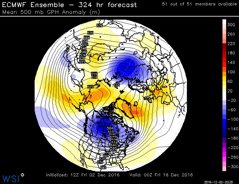
For those of us worried about a mild flip into Christmas... I don't believe we will be seeing that per the long range ensembles.
Team #NeverSummer
So to be clear, the Houston area is expecting up to 10 inches of rain over a 3 day period of time? Not a flooding situation like this past spring, right?
Thank you for all you do to keep us informed and safe!
Thank you for all you do to keep us informed and safe!

I'm hearing that it may rain this weekend?