
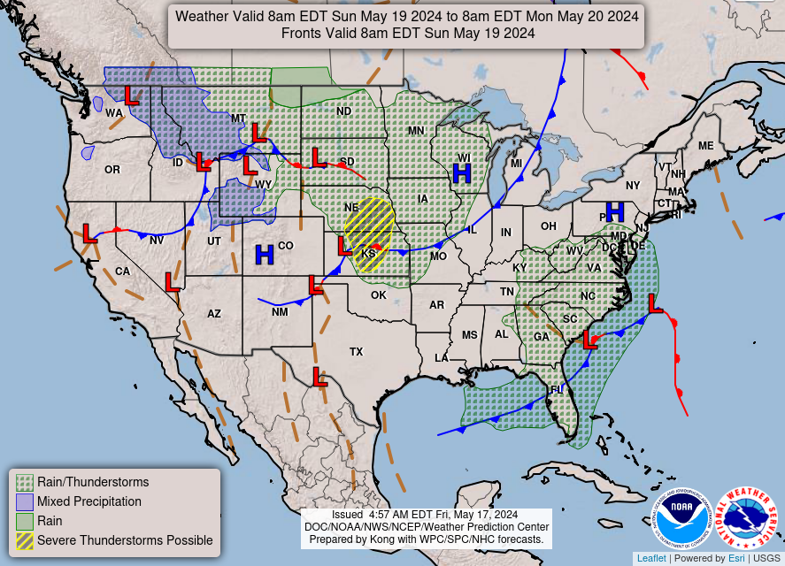
November 2016 -will cooler temps prevail along with rain
Yay for having to water the lawn in October and now in November. Summer from hell comtinues...
-
A.V.
Ohh.jasons wrote:A cap in November?? Geez. Amazing that areas to our north and west are getting a soaking and here along the coast we sit high and dry.
Last edited by A.V. on Fri Nov 04, 2016 8:43 pm, edited 1 time in total.
-
A.V.
Cromagnum wrote:Yay for having to water the lawn in October and now in November. Summer from hell comtinues...
While the rain is needed, the Nov-March period is, honestly, the absolute best time for long dry-spells/dryness to happen; evaporation from the plants is limited, so drought stress is minimized, and the weather is dry, warm and sunny, rather than cold, wet, freezing and gloomy.jasons wrote:A cap in November?? Geez. Amazing that areas to our north and west are getting a soaking and here along the coast we sit high and dry.
Summer (late May-early October) is the best time for rains to happen; heavy, soaking rains just aren't right outside of that range.

I haven't had a good soaking since April, so yes I need the rain.
-
srainhoutx

- Site Admin

- Posts: 19616
- Joined: Tue Feb 02, 2010 2:32 pm
- Location: Maggie Valley, NC
- Contact:
Friday morning briefing from Jeff:
Record warmth of the last few days (88 at IAH yesterday) will be replaced to cooler and wetter conditions over the next week.
Heavy rainfall occurred yesterday afternoon and evening over portions of the area with a large part of Colorado County receiving widespread rainfall of 2-4 inches. A weak cool front will slide into the region today and may offer a slight chances of late afternoon thunderstorms across the area.
A slightly drier air mass will only briefly filter into the region tonight into Saturday before Gulf moisture makes a robust return to the region Saturday night into Sunday. ECMWF and even the latest GFS run is showing some QPF Saturday afternoon over the region as a strong disturbance moves across TX. In the upper levels, the sub-tropical ridge which has been anchored over S TX for the last few weeks will begin to break down allowing a cooling trend in temperatures and a more favorable rainfall pattern. An upper level storm system will approach SW/W TX Sunday and shear across TX early next week.
Robust moisture return on Sunday in strong warm air advection pattern will likely support the formation of scattered to numerous northward moving showers and thunderstorms…especially Sunday afternoon. Sub-tropical jet stream noses into the region Sunday evening with a splitting jet stream and favorable upper level divergence aloft. Surface coastal trough will be forced near the coast providing a surface trigger and PWS rise to 1.8-2.0 inches. This all points to good rain chances…especially along and SE of US 59 during this period. Do not think severe weather is likely at this point, but heavy rainfall will certainly be possible.
Will broad brush rainfall totals today-Tuesday of 1-3 inches across the region with isolated amounts of 5 inches especially near the coast where deepest moisture will reside. Will need to watch activity closely Sunday night into Monday for any signs of sustained cell training which would increase these QPF numbers. Dry grounds across the area should be able to handle much of this rainfall as long as it falls over a spread out time period and not all in a short duration.
Note: While the last few months have been fairly dry over the region, now is a good time to remind residents that the majority of the fatalities (19) in the last 18 months of flooding in Harris County were vehicle related and mostly at underpasses. It is important to remember not to drive into high water and in the unfortunate situation where one does find themselves trapped in a vehicle in high water…get out of the vehicle immediately.
Note: Day Light Saving Time begins Sunday morning at 200am when clocks “fall back” one hour.
Carla/Alicia/Jerry(In The Eye)/Michelle/Charley/Ivan/Dennis/Katrina/Rita/Wilma/Humberto/Ike/Harvey
Member: National Weather Association
Facebook.com/Weather Infinity
Twitter @WeatherInfinity
Member: National Weather Association
Facebook.com/Weather Infinity
Twitter @WeatherInfinity
-
TexasBreeze
- Posts: 942
- Joined: Sun Sep 26, 2010 4:46 pm
- Location: NW Houston, TX
- Contact:
Along and south of 59? Doesn't bode well for soaking rain for north of that area and most rain could stay offshore maybe...
-
A.V.
Not even in May, June, July, or August?jasons wrote:I haven't had a good soaking since April, so yes I need the rain.

Looks unsettled for the weekend and Monday. Hoped to get out now that temp is temperate. Rainfall has potential to be widespread.
.PREV DISCUSSION... /ISSUED 411 PM CDT Fri Nov 4 2016/
Near term forecast will have to focus on existing convection, as
well as potential for more showers and a stray storm far inland
tonight. Perhaps the most pressing concern of the forecast period
comes Sunday night into Monday, as ingredients are coming together
to suggest a chance for some locally heavy rain. Afterwards,
rainfall potential decreases some, but unsettled weather can be
expected for much of the week.
Tonight into Saturday...
Radar shows scattered showers inland, roughly north and west of a
line from Victoria to Cleveland, while areas coastward are drier.
ENTLN has shown a single CG lightning strike, with some sporadic
cloud flashes and pulses. The limited activity indicates that
while lightning can`t be ruled out, cells today don`t look to be
very electrically active. Tonight, after these storms diminish,
multiple convective allowing models generate an area of convection
in Central Texas. While drier, easterly flow seems to keep the
most significant convection north of our area, went ahead and
raised PoPs. Forcing is not terribly strong from a shortwave
trough , but these models do indicate some subtle surface
convergence, and perhaps remnant boundaries from this afternoon`s
activity will be enough to get some convection going. At the same
time, wouldn`t be surprised if initiation fails, and tonight ends
up being dry, so tried not to get too crazy with raising PoPs.
Forcing should be at least enough to keep fog from being as much
of a concern as it was this morning.
Sunday into Monday...
Later in the weekend, a cutoff low over the Desert Southwest will
open up and move eastward. At the surface, onshore flow will
continue to boost precipitable water along with a developing
coastal trough. In the meantime, a 90kt upper jet enters the area,
putting our part of SE Texas underneath either its nose, either
more to the right or left exit region depending on which model you
prefer. In general, this should support higher precip chances. The
Euro, putting us under the right exit, is more towards the drier
end. The GFS, which is a touch more to the south, is much wetter.
There is at least a potential for some locally heavy rainfall as
the ingredients needed will all be there. The question is if they
will all come together in the right place and right time, or if -
as the Euro suggests - they will be just out of phase enough to
keep things a bit drier.
Tuesday and beyond...
Afterwards, jet dynamics over our area should weaken, diminishing
the threat of heavier rain. However, aloft, the upper trough
becomes very positively tilted, and leaves behind a lobe of
vorticity and a cutoff low again to our west. This is likely to
keep unsettled weather with us deep into the week, and so precip
chances are likely to linger with skies remaining cloudier. On
the plus side (at least to those of us who grew up in the snowy
north), temperatures should be cooler relative to the lack of
fall we`ve had thus far. Just beyond this forecast period, a
frontal passage may bring in drier air and an end to the unsettled
weather expected in the week to come.
&&
-
srainhoutx
- Site Admin
- Posts: 19616
- Joined: Tue Feb 02, 2010 2:32 pm
- Location: Maggie Valley, NC
- Contact:
Morning showers and some rumbles of thunder possible, particularly the Northern areas today as an upper level disturbance to our West continues to spin.
The overnight guidance continues to advertise an unsettled weather pattern well into next week with abundant tropical moisture from the Eastern Pacific spreading over Texas and a possible weak surface low/trough developing along the NW Gulf. Heavy rainfall rates could be possible tomorrow night into Monday, possibly extending into Election Day.
The overnight guidance continues to advertise an unsettled weather pattern well into next week with abundant tropical moisture from the Eastern Pacific spreading over Texas and a possible weak surface low/trough developing along the NW Gulf. Heavy rainfall rates could be possible tomorrow night into Monday, possibly extending into Election Day.
- Attachments
-
Carla/Alicia/Jerry(In The Eye)/Michelle/Charley/Ivan/Dennis/Katrina/Rita/Wilma/Humberto/Ike/Harvey
Member: National Weather Association
Facebook.com/Weather Infinity
Twitter @WeatherInfinity
Member: National Weather Association
Facebook.com/Weather Infinity
Twitter @WeatherInfinity
-
srainhoutx
- Site Admin
- Posts: 19616
- Joined: Tue Feb 02, 2010 2:32 pm
- Location: Maggie Valley, NC
- Contact:
Sunday morning briefing from Jeff:
Factors coming together to produce a widespread rainfall event today-Monday
A slow moving upper level low will meander into W TX today while a surge a tropical moisture moves inland over TX from the Gulf of Mexico. Morning radar already shows showers and thunderstorms ongoing along the middle TX coast and this area of activity will expand inland today.
By late afternoon into the overnight hours and into Monday strong jet dynamics will come to bear across the region with a 80kt sub-tropical jet stream nosing into the area and moisture surging into the 1.60-1.90 inch range of PW. Forecast soundings become increasingly saturated tonight into Monday. Formation of a coastal trough will likely help to add a surface trigger under a broadly divergent upper level wind field. All the ingredients point to widespread rainfall starting later this afternoon and lasting for a good part of Monday.
Could certainly see some heavy rainfall with this activity given the moisture setup and sustained lift from both the coastal trough and divergent upper air winds. Think the most favored time frame for heavy rains will be tonight into midday Monday.
Rainfall totals of 1-3 inches will be likely along and SW of I-45 with 1-2 inches east of I-45. Isolated totals of 3-5 inches will be possible. Dry grounds should absorb much of this rainfall, but where heavy rains occur some run-off will result. At this point think any flooding will be limited to urban areas where heavy rainfall rates may exceed local drainage capacities in short duration time frames.
Pattern going forward after Monday is uncertain with the GFS and ECMWF completely different in their handling of the upper air pattern over TX. The ECMWF keeps a wet overrunning pattern into place into Election Day and beyond while the GFS shows a drier zonal flow. The CMC does support the ECMWF upper air pattern, but does not generate as much QPF as the ECMWF does. Will lean toward the ECWMF, but keep rain chances in the 40% range or less for now. It may end up cloudy in an overrunning type event…but not much rainfall if drier surface air invades from the NE.
Strong cold front appears likely toward next weekend with a good chance of more showers and thunderstorms Friday and Saturday followed by significantly colder conditions.
Carla/Alicia/Jerry(In The Eye)/Michelle/Charley/Ivan/Dennis/Katrina/Rita/Wilma/Humberto/Ike/Harvey
Member: National Weather Association
Facebook.com/Weather Infinity
Twitter @WeatherInfinity
Member: National Weather Association
Facebook.com/Weather Infinity
Twitter @WeatherInfinity
looks like it might be starting to congeal a bit? I sure hope so - we have been reduced from 60-70% earlier today to 50% for rain - we need it badly, live oaks starting to drop leaves  radar actually looks better for us right now
http://radar.weather.gov/Conus/southplains_loop.php

edit: really happy with lower temps !
http://radar.weather.gov/Conus/southplains_loop.php
edit: really happy with lower temps !

THE NATIONAL WEATHER SERVICE IN LEAGUE CITY HAS ISSUED A
* FLOOD ADVISORY FOR...
GRIMES COUNTY IN SOUTHEASTERN TEXAS...
SOUTHEASTERN BRAZOS COUNTY IN SOUTHEASTERN TEXAS...
SOUTH CENTRAL MADISON COUNTY IN SOUTHEASTERN TEXAS...
* UNTIL 830 PM CST.
* AT 623 PM CST...DOPPLER RADAR INDICATED SLOW MOVING HEAVY RAINFALL
IN THE AREA. RADAR ESTIMATES 1 TO 3 INCHES OF RAIN HAS ALREADY FALLEN
IN PARTS OF THE AREA. SOME CELLS ARE PRODUCING RATES BETWEEN 2 AND
2.5 INCHES PER HOUR. ADDITIONAL HEAVY RAIN WILL CAUSE MINOR FLOODING
IN THE ADVISORY AREA.
* SOME LOCATIONS THAT WILL EXPERIENCE FLOODING INCLUDE...
SOUTHEASTERN COLLEGE STATION...NAVASOTA...BEDIAS...MILLICAN...
ANDERSON...IOLA...RICHARDS...CARLOS AND ROANS PRAIRIE.
PRECAUTIONARY/PREPAREDNESS ACTIONS...
TURN AROUND...DON`T DROWN WHEN ENCOUNTERING FLOODED ROADS. MOST FLOOD
DEATHS OCCUR IN VEHICLES.
BE ESPECIALLY CAUTIOUS AT NIGHT WHEN IT IS HARDER TO RECOGNIZE THE
DANGERS OF FLOODING.
~~~When Thunder Roars Go Indoors~~~
~~~Turn Around Don't Drown~~~
~~~Run From The Water, Hide From The Wind~~~
~~~Turn Around Don't Drown~~~
~~~Run From The Water, Hide From The Wind~~~
unome wrote:looks like it might be starting to congeal a bit? I sure hope so - we have been reduced from 60-70% earlier today to 50% for rain - we need it badly, live oaks starting to drop leaves
http://radar.weather.gov/Conus/southplains_loop.php
edit: really happy with lower temps !
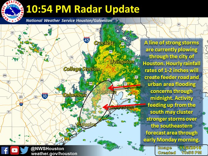
Bullseye on TW Harris Co.
Woah - 3.25 in IMBY here in College Station and still coming down. First really significant rain with a single exception since mid-August. Feast or famine in Tejas!
happy for your rain & here as well - a wonderful chime to sleep by, rumbles of thunder & lightning, but not damaging weatherDoctorMu wrote:Bullseye on TW Harris Co.
Woah - 3.25 in IMBY here in College Station and still coming down. First really significant rain with a single exception since mid-August. Feast or famine in Tejas!
-
MontgomeryCoWx

- Posts: 2356
- Joined: Wed Dec 14, 2011 4:31 pm
- Location: Weimar, TX
- Contact:
Team #NeverSummer
what is this showing?
THE NATIONAL WEATHER SERVICE IN LEAGUE CITY HAS ISSUED A
* FLOOD ADVISORY FOR...
HARRIS COUNTY IN SOUTHEASTERN TEXAS...
* UNTIL 1115 PM CST.
* AT 1011 PM CST...DOPPLER RADAR INDICATED HEAVY RAIN MOVING THROUGH
THE HOUSTON METRO AREA. RAINFALL RATES AS HIGH AS 1 INCH FALLING
IN 10 MINUTES HAVE BEEN OBSERVED AT SOME LOCATIONS INCLUDING
GREENS BAYOU AT CUTTEN ROAD. RATES THIS HIGH WILL CAUSE SOME
STREET FLOODING IN URBAN AREAS AND FEEDER ROADS.
* SOME LOCATIONS THAT WILL EXPERIENCE FLOODING INCLUDE...
NORTHWESTERN PASADENA...BELLAIRE...HUMBLE...WEST UNIVERSITY
PLACE...GALENA PARK...JACINTO CITY...JERSEY VILLAGE...HUNTERS CREEK
VILLAGE...BUNKER HILL VILLAGE...PINEY POINT VILLAGE...SPRING
VALLEY...GREATER FIFTH WARD...SPRING BRANCH WEST...NEARTOWN /
MONTROSE...SECOND WARD...NEAR NORTHSIDE HOUSTON...GREENWAY / UPPER
KIRBY AREA...SPRING...UNIVERSITY PLACE AND AFTON OAKS / RIVER OAKS
AREA.
PRECAUTIONARY/PREPAREDNESS ACTIONS...
TURN AROUND...DON`T DROWN WHEN ENCOUNTERING FLOODED ROADS. MOST FLOOD
DEATHS OCCUR IN VEHICLES.
BE ESPECIALLY CAUTIOUS AT NIGHT WHEN IT IS HARDER TO RECOGNIZE THE
DANGERS OF FLOODING.
~~~When Thunder Roars Go Indoors~~~
~~~Turn Around Don't Drown~~~
~~~Run From The Water, Hide From The Wind~~~
~~~Turn Around Don't Drown~~~
~~~Run From The Water, Hide From The Wind~~~
Last edited by djjordan on Sun Nov 06, 2016 11:02 pm, edited 2 times in total.
~~~When Thunder Roars Go Indoors~~~
~~~Turn Around Don't Drown~~~
~~~Run From The Water, Hide From The Wind~~~
~~~Turn Around Don't Drown~~~
~~~Run From The Water, Hide From The Wind~~~


I see a large upper level trough over Southeast Texas. That means rain and cooler weather. Perhaps severe weather?
-
- Information
-
Who is online
Users browsing this forum: Ahrefs [Bot], Bing [Bot], TexasBreeze and 74 guests