
TXC039-167-022300-
/O.NEW.KHGX.FA.Y.0024.100602T2057Z-100602T2300Z/
/00000.N.ER.000000T0000Z.000000T0000Z.000000T0000Z.OO/
BRAZORIA TX-GALVESTON TX-
357 PM CDT WED JUN 2 2010
THE NATIONAL WEATHER SERVICE IN LEAGUE CITY HAS ISSUED AN
* URBAN AND SMALL STREAM FLOOD ADVISORY FOR...
NORTHERN BRAZORIA COUNTY IN SOUTHEAST TEXAS...
NORTHWESTERN GALVESTON COUNTY IN SOUTHEAST TEXAS...
* UNTIL 600 PM CDT
* AT 355 PM CDT...NATIONAL WEATHER SERVICE DOPPLER RADAR INDICATED
VERY HEAVY RAIN WAS FALLING NEAR ALVIN...AND BETWEEN MANVEL AND
HILLCREST. THESE STORMS WERE REDEVELOPING OVER THE SAME AREAS. RADAR
ESTIMATES 2 TO 3 INCHES OF RAIN HAS FALLEN OVER THE AREA AND
ADDITIONAL 2 INCHES ARE A POSSIBILITY. DO NOT DRIVE ACROSS WATER
COVERED ROADWAYS.
June Weather Discussion
-
srainhoutx

- Site Admin

- Posts: 19616
- Joined: Tue Feb 02, 2010 2:32 pm
- Location: Maggie Valley, NC
- Contact:
Carla/Alicia/Jerry(In The Eye)/Michelle/Charley/Ivan/Dennis/Katrina/Rita/Wilma/Humberto/Ike/Harvey
Member: National Weather Association
Facebook.com/Weather Infinity
Twitter @WeatherInfinity
Member: National Weather Association
Facebook.com/Weather Infinity
Twitter @WeatherInfinity
-
srainhoutx
- Site Admin
- Posts: 19616
- Joined: Tue Feb 02, 2010 2:32 pm
- Location: Maggie Valley, NC
- Contact:
SPECIAL WEATHER STATEMENT
NATIONAL WEATHER SERVICE HOUSTON/GALVESTON TX
418 PM CDT WED JUN 2 2010
TXZ213-022145-
HARRIS-
418 PM CDT WED JUN 2 2010
...SIGNIFICANT WEATHER ADVISORY...
AT 414 PM CDT...NATIONAL WEATHER SERVICE DOPPLER RADAR INDICATED A
STRONG THUNDERSTORM NEAR ALDINE...MOVING NORTHWEST AT 10 MPH.
THIS STORM HAS THE POTENTIAL TO PRODUCE NEAR NICKEL SIZE HAIL.
HOURLY RAINFALL RATES OF BETWEEN 1/2 AND ONE INCH WILL OCCUR WITH
THIS THUNDERSTORM. TEMPORARY WATER OVER FEEDER ROADS AND LOWER LYING
ROADWAYS WILL OCCUR THROUGH 5:30 PM CDT.
Carla/Alicia/Jerry(In The Eye)/Michelle/Charley/Ivan/Dennis/Katrina/Rita/Wilma/Humberto/Ike/Harvey
Member: National Weather Association
Facebook.com/Weather Infinity
Twitter @WeatherInfinity
Member: National Weather Association
Facebook.com/Weather Infinity
Twitter @WeatherInfinity
-
srainhoutx
- Site Admin
- Posts: 19616
- Joined: Tue Feb 02, 2010 2:32 pm
- Location: Maggie Valley, NC
- Contact:
SPECIAL WEATHER STATEMENT
NATIONAL WEATHER SERVICE HOUSTON/GALVESTON TX
446 PM CDT WED JUN 2 2010
TXZ227-237-022215-
BRAZORIA-FORT BEND-
446 PM CDT WED JUN 2 2010
...SIGNIFICANT WEATHER ADVISORY...
AT 444 PM CDT...NATIONAL WEATHER SERVICE DOPPLER RADAR INDICATED A
STRONG THUNDERSTORM OVER EXTREME SOUTH CENTRAL FORT BEND COUNTY...
MOVING EAST AT 10 MPH.
NICKEL SIZE HAIL...FREQUENT CLOUD TO GROUND LIGHTNING...BRIEF HEAVY
DOWNPOURS...ARE POSSIBLE WITH THIS STORM.
LOCATIONS IN THE PATH OF THIS STORM INCLUDE...DAMON...BRAZOS BEND
STATE PARK.
Carla/Alicia/Jerry(In The Eye)/Michelle/Charley/Ivan/Dennis/Katrina/Rita/Wilma/Humberto/Ike/Harvey
Member: National Weather Association
Facebook.com/Weather Infinity
Twitter @WeatherInfinity
Member: National Weather Association
Facebook.com/Weather Infinity
Twitter @WeatherInfinity
-
srainhoutx
- Site Admin
- Posts: 19616
- Joined: Tue Feb 02, 2010 2:32 pm
- Location: Maggie Valley, NC
- Contact:
Could get interesting around here later tonight...
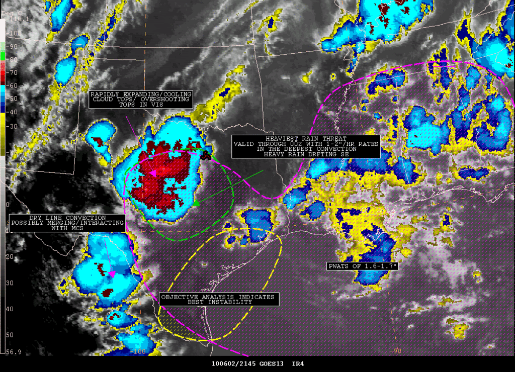
SATELLITE PRECIPITATION ESTIMATES..DATE/TIME 06/02/10 2200Z
SATELLITE ANALYSIS BRANCH/NESDIS---NPPU---TEL.301-763-8678
LATEST DATA USED: GOES-13 2145Z JANKOT
.
LOCATION...LOUISIANA...TEXAS...
.
ATTN WFOS...LCH...HGX...FWD...OUN...CRP...EWX...SJT...MAF...
ATTN RFCS...LMRFC...WGRFC...
.
EVENT...MCS DEVELOPING OVER CENTRAL TEXAS DRIFTING SE
.
SATELLITE ANALYSIS AND TRENDS...LATEST WATER VAPOR IMAGERY SHOWS A VORT
OVER NORTH CENTRAL TEXAS AND IR IMAGERY SHOWS RAPID COOLING AND EXPANDING
CLOUD TOPS OVER THE DISCUSSION AREA WITH OVER SHOOTING CLOUD TOPS SEEN
IN THE VIS. MOISTURE HAS BEEN INCREASING THE LAST FEW HOURS NORTHWARD AS
SEEN IN THE BLENDED TPW WITH PWATS AROUND 1.7" IN SE TEXAS. WIND PROFILERS
IN SE TEXAS SHOW 15 KNOT SE LOW LEVEL JET AT H925 AND H850 SUGGESTING
MOISTURE ADVECTION WILL CONTINUE FOR THE NEXT SEVERAL HOURS. OBJECTIVE
ANALYSIS SHOWS THE BEST INSTABILITY OVER FAR SE TEXAS AND BELIEVE THE MCS
WILL PROGRESS SE TOWARDS THE BETTER INSTABILITY THE NEXT FEW HOURS. MANUAL
SATELLITE ESTIMATES SHOW RAIN RATES AROUND 1.0"/30 MIN AND BELIEVE RATES
IN THE DEEPEST CORES ARE RUNNING 1-2"/HR. CONVECTION ALONG THE DRYLINE
IN MEXICO IS ALSO RAPIDLY EXPANDING NORTHEASTWARD AND COULD MERGE WITH
THE MCS ENHANCING RAINFALL POTENTIAL.
AN ANNOTATED SATELLITE GRAPHIC OUTLINING HEAVY RAIN THREAT SHOULD BE
AVAILABLE ON THE WEBSITE LISTED BELOW IN APPROXIMATELY 10-15 MINUTES.
SHORT TERM OUTLOOK VALID 22Z-0Z...MEDIUM CONFIDENCE IN THE SHORT TERM
OUTLOOK...MCS SHOULD DRIFT SE TOWARDS THE BETTER INSTABILITY AS OUTLINED
ABOVE. THE HEAVIEST RAIN IS CURRENTLY MOVING QUICKLY SE BUT BELIEVE
1-2"/HR RATES ARE POSSIBLE IN THE DEEPEST CONVECTION. FFG IS RATHER HIGH
OVER THE DISCUSSION AREA BUT WITH MERGERS AND RAPIDLY EXPANDING/COOLING
CLOUD TOPS THERE IS THE POTENTIAL FOR SEVERAL INCHES OF RAIN WITH AN
EMPHASIS MORE ON SE TEXAS. WILL CONTINUE TO MONITOR.
Carla/Alicia/Jerry(In The Eye)/Michelle/Charley/Ivan/Dennis/Katrina/Rita/Wilma/Humberto/Ike/Harvey
Member: National Weather Association
Facebook.com/Weather Infinity
Twitter @WeatherInfinity
Member: National Weather Association
Facebook.com/Weather Infinity
Twitter @WeatherInfinity

Looks like a stormy night ahead as a MCS develops off to our west and moves through the area. Hopefully it will spread an even splosh of 1 to 2 inches of rain over the area...
There has been some hype for a very hot and dry forecast to begin this weekend and last through the next work week, but if the Euro verifies those forecasts are in deep trouble... Interesting that the GFS still wants to build a strong upper ridge over the area with temperatures warming to near 100 next week, while the Euro leaves a weakness in the flow across the area through the forecast period, bringing a daily chance of rain and temperatures nowhere near 100...
I haven't really jumped on the record breaking heat, dry train yet... Personally, I would almost lean towards the wetter, cooler Euro solution. Recall that a few days ago the Euro model was forecasting an active period today through tommorow, while the GFS was showing nothing but dryness and heat. Of course, we now know that the Euro was right and the GFS was mishandling the current shortwave disturbance that will be pushing through the area tonight. As far as next week's forecast is concerned, the GFS has continuously been the warmest model, showing a much stronger upper ridge building over the area than any other model solution I've seen. Even its own ensemble members are beginning to lean towards the Euro solution. It just looks too extreme to me for this time of year (earliest 100 degree temp on record for Houston is June 10th), and I don't see any support from the CMC, Euro, or UKMET solutions showing upper heights building to near 594 dm.... This is still early June, not early August.
Last edited by Mr. T on Wed Jun 02, 2010 5:48 pm, edited 1 time in total.
-
srainhoutx
- Site Admin
- Posts: 19616
- Joined: Tue Feb 02, 2010 2:32 pm
- Location: Maggie Valley, NC
- Contact:
FLOOD ADVISORY
NATIONAL WEATHER SERVICE HOUSTON/GALVESTON TX
519 PM CDT WED JUN 2 2010
TXC039-157-030015-
/O.NEW.KHGX.FA.Y.0025.100602T2219Z-100603T0015Z/
/00000.N.ER.000000T0000Z.000000T0000Z.000000T0000Z.OO/
FORT BEND TX-BRAZORIA TX-
519 PM CDT WED JUN 2 2010
THE NATIONAL WEATHER SERVICE IN LEAGUE CITY HAS ISSUED AN
* URBAN AND SMALL STREAM FLOOD ADVISORY FOR...
WESTERN BRAZORIA COUNTY IN SOUTHEAST TEXAS...
SOUTHERN FORT BEND COUNTY IN SOUTHEAST TEXAS...
* UNTIL 715 PM CDT
* AT 517 PM CDT...NATIONAL WEATHER SERVICE DOPPLER RADAR INDICATED
VERY HEAVY RAIN WAS FALLING OVER SOUTHERN FORT BEND COUNTY.
LOCALLY HEAVY HOURLY RAINFALL RATES OF BETWEEN 2 TO 3 INCHES HAVE
OCCURRED WITH THIS STORM SINCE 430 PM. NICKEL SIZE HAIL AND FREQUENT
CLOUD TO GROUND LIGHTNING ARE ALSO POSSIBLE WITH THIS STORM.
Carla/Alicia/Jerry(In The Eye)/Michelle/Charley/Ivan/Dennis/Katrina/Rita/Wilma/Humberto/Ike/Harvey
Member: National Weather Association
Facebook.com/Weather Infinity
Twitter @WeatherInfinity
Member: National Weather Association
Facebook.com/Weather Infinity
Twitter @WeatherInfinity
Is there anymore expected rain for my area? I was wanting to put out a barrel to catch rain water in for the garden  Hopefully nothing to severe......
My name is Nicole and I love weather!!
~~~~~~~~~~~~~~~~~~~~~~~~~~~~~~~~~~~~~~~~~~~~~~~~~~~~~~~~~~~~~~~~~~~~~~~~~~~~~~~~~~~~~~~~~~~~~~~~
Alicia, Allison, Rita, Ike
~~~~~~~~~~~~~~~~~~~~~~~~~~~~~~~~~~~~~~~~~~~~~~~~~~~~~~~~~~~~~~~~~~~~~~~~~~~~~~~~~~~~~~~~~~~~~~~~
Alicia, Allison, Rita, Ike
-
srainhoutx
- Site Admin
- Posts: 19616
- Joined: Tue Feb 02, 2010 2:32 pm
- Location: Maggie Valley, NC
- Contact:
Looks like an active 24 hours or so for our area. The Storm Complex (MCS) in Central TX will approach the area overnight. HGX thinking that left over boundaries with be the rule tomorrow afternoon for more storm development. Could be a busy night for the 'night crew'... 
Carla/Alicia/Jerry(In The Eye)/Michelle/Charley/Ivan/Dennis/Katrina/Rita/Wilma/Humberto/Ike/Harvey
Member: National Weather Association
Facebook.com/Weather Infinity
Twitter @WeatherInfinity
Member: National Weather Association
Facebook.com/Weather Infinity
Twitter @WeatherInfinity


I hope to see more rain this month. It looks to be rainy tonight and tomorrow.Mr. T wrote:Looks like a stormy night ahead as a MCS develops off to our west and moves through the area. Hopefully it will spread an even splosh of 1 to 2 inches of rain over the area...
There has been some hype for a very hot and dry forecast to begin this weekend and last through the next work week, but if the Euro verifies those forecasts are in deep trouble... Interesting that the GFS still wants to build a strong upper ridge over the area with temperatures warming to near 100 next week, while the Euro leaves a weakness in the flow across the area through the forecast period, bringing a daily chance of rain and temperatures nowhere near 100...
I haven't really jumped on the record breaking heat, dry train yet... Personally, I would almost lean towards the wetter, cooler Euro solution. Recall that a few days ago the Euro model was forecasting an active period today through tommorow, while the GFS was showing nothing but dryness and heat. Of course, we now know that the Euro was right and the GFS was mishandling the current shortwave disturbance that will be pushing through the area tonight. As far as next week's forecast is concerned, the GFS has continuously been the warmest model, showing a much stronger upper ridge building over the area than any other model solution I've seen. Even its own ensemble members are beginning to lean towards the Euro solution. It just looks too extreme to me for this time of year (earliest 100 degree temp on record for Houston is June 10th), and I don't see any support from the CMC, Euro, or UKMET solutions showing upper heights building to near 594 dm.... This is still early June, not early August.
-
sleetstorm
- Posts: 651
- Joined: Thu Feb 04, 2010 12:33 pm
- Contact:
Hey, Ptarmigan, it looks like you are in for some somewhat impressive thunderstorms from what I saw on KHOU's Dopplar Radar. That line of thunderstorms, which has curved eastward and is just west of the of Austin, may produce some strong gusty wind up to if not more than forty or fifty m.p.h.
-
srainhoutx
- Site Admin
- Posts: 19616
- Joined: Tue Feb 02, 2010 2:32 pm
- Location: Maggie Valley, NC
- Contact:
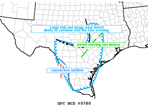
MESOSCALE DISCUSSION 0780
NWS STORM PREDICTION CENTER NORMAN OK
0732 PM CDT WED JUN 02 2010
AREAS AFFECTED...LARGE PART OF S-CNTRL TX
CONCERNING...SEVERE THUNDERSTORM WATCH 247...
VALID 030032Z - 030130Z
THE SEVERE WEATHER THREAT FOR SEVERE THUNDERSTORM WATCH 247
CONTINUES.
STRONG TO SEVERE TSTMS WILL LIKELY CONTINUE INTO THE LATE EVENING
HOURS ACROSS MUCH OF S-CNTRL TX. THE SEVERE THREAT IS EXPECTED TO
PERSIST BEYOND 03Z AND SPREAD OUTSIDE OF THE CURRENT WW AND A NEW WW
WILL PROBABLY BE REQUIRED FOR PORTIONS OF S-CNTRL AND PERHAPS DEEP S
TX.
RECENT TRENDS IN RADAR MOSAIC SHOW A WELL ORGANIZED BOWING
CONVECTIVE SYSTEM NEAR THE I-35 CORRIDOR BETWEEN ACT TO SAT AND IT
EXTENDS WNWWD INTO THE TX HILL COUNTRY. THIS SYSTEM IS LIKELY TO
EVENTUALLY MERGE WITH A DEVELOPING TSTM CLUSTER PUSHING EWD ACROSS
THE RIO GRANDE NEAR LRD. SURFACE ANALYSIS SHOWS A VERY MOIST LOW
LEVEL MOIST FETCH OFF THE NWRN GULF...CHARACTERIZED BY DEWPOINTS
WELL INTO THE 70S DEG F.
A VERY FAVORABLE THERMODYNAMIC ENVIRONMENT WITH STEEP MID LEVEL
LAPSE RATES WAS DENOTED ON THE 00Z BRO RAOB /MLCAPE OF 4000 J/KG/.
ADEQUATE CLOUD BEARING SHEAR AROUND 30 KTS WILL BE MORE THAN
SUFFICIENT TO AID IN CONTINUED UPSCALE GROWTH OF BOTH TSTM
COMPLEXES. THE MAIN THREATS WITH THIS ACTIVITY WILL BE DMGG WINDS
AND LARGE HAIL.
..SMITH.. 06/03/2010
ATTN...WFO...HGX...FWD...CRP...EWX...BRO...SJT...
Carla/Alicia/Jerry(In The Eye)/Michelle/Charley/Ivan/Dennis/Katrina/Rita/Wilma/Humberto/Ike/Harvey
Member: National Weather Association
Facebook.com/Weather Infinity
Twitter @WeatherInfinity
Member: National Weather Association
Facebook.com/Weather Infinity
Twitter @WeatherInfinity
-
sleetstorm
- Posts: 651
- Joined: Thu Feb 04, 2010 12:33 pm
- Contact:
What about tomorrow, srainhoutx? Does the same also apply for tomorrow as far as severe thunderstorms?
Hey Sleetstorm. It looks to be a stormy night tonight. Nice to see some rain for a change.sleetstorm wrote:Hey, Ptarmigan, it looks like you are in for some somewhat impressive thunderstorms from what I saw on KHOU's Dopplar Radar. That line of thunderstorms, which has curved eastward and is just west of the of Austin, may produce some strong gusty wind up to if not more than forty or fifty m.p.h.
-
srainhoutx
- Site Admin
- Posts: 19616
- Joined: Tue Feb 02, 2010 2:32 pm
- Location: Maggie Valley, NC
- Contact:
SPC issues a Severe Thunderstorm Watch for S TX. Does not include SE TX...
URGENT - IMMEDIATE BROADCAST REQUESTED
SEVERE THUNDERSTORM WATCH NUMBER 249
NWS STORM PREDICTION CENTER NORMAN OK
755 PM CDT WED JUN 2 2010
THE NWS STORM PREDICTION CENTER HAS ISSUED A
SEVERE THUNDERSTORM WATCH FOR PORTIONS OF
SOUTH CENTRAL AND SOUTH TEXAS
COASTAL WATERS
EFFECTIVE THIS WEDNESDAY NIGHT AND THURSDAY MORNING FROM 755 PM
UNTIL 300 AM CDT.
HAIL TO 2 INCHES IN DIAMETER...THUNDERSTORM WIND GUSTS TO 70
MPH...AND DANGEROUS LIGHTNING ARE POSSIBLE IN THESE AREAS.
THE SEVERE THUNDERSTORM WATCH AREA IS APPROXIMATELY ALONG AND 100
STATUTE MILES EAST AND WEST OF A LINE FROM 45 MILES NORTH
NORTHWEST OF SAN ANTONIO TEXAS TO 70 MILES SOUTH SOUTHWEST OF
ALICE TEXAS. FOR A COMPLETE DEPICTION OF THE WATCH SEE THE
ASSOCIATED WATCH OUTLINE UPDATE (WOUS64 KWNS WOU9).
REMEMBER...A SEVERE THUNDERSTORM WATCH MEANS CONDITIONS ARE
FAVORABLE FOR SEVERE THUNDERSTORMS IN AND CLOSE TO THE WATCH
AREA. PERSONS IN THESE AREAS SHOULD BE ON THE LOOKOUT FOR
THREATENING WEATHER CONDITIONS AND LISTEN FOR LATER STATEMENTS
AND POSSIBLE WARNINGS. SEVERE THUNDERSTORMS CAN AND OCCASIONALLY
DO PRODUCE TORNADOES.
OTHER WATCH INFORMATION...CONTINUE...WW 247...WW 248...
DISCUSSION...SEVERAL LARGE THUNDERSTORM CLUSTERS WILL LIKELY PERSIST
OVERNIGHT WITH THE POTENTIAL FOR CLUSTER MERGERS ACROSS S CENTRAL TX
LATER THIS EVENING. SOME INCREASE IN STORM INTENSITY IS ALSO
EXPECTED BETWEEN VCT AND AUS AS SEPARATE OUTFLOW BOUNDARIES COLLIDE.
A LARGE RESERVOIR OF 3000-4000 J/KG MLCAPE WILL HELP MAINTAIN THE
CONVECTION AND THE CONTINUING RISK FOR DAMAGING WINDS AND LARGE
HAIL.
Carla/Alicia/Jerry(In The Eye)/Michelle/Charley/Ivan/Dennis/Katrina/Rita/Wilma/Humberto/Ike/Harvey
Member: National Weather Association
Facebook.com/Weather Infinity
Twitter @WeatherInfinity
Member: National Weather Association
Facebook.com/Weather Infinity
Twitter @WeatherInfinity

I won't stay up for this, if I do.... It's poof for everyone, south of I-10

-
srainhoutx
- Site Admin
- Posts: 19616
- Joined: Tue Feb 02, 2010 2:32 pm
- Location: Maggie Valley, NC
- Contact:
I would not be surprised to see an additional watch issued a bit closer to SE TX.
http://radar.weather.gov/Conus/southplains_loop.php
http://radar.weather.gov/Conus/southplains_loop.php
Carla/Alicia/Jerry(In The Eye)/Michelle/Charley/Ivan/Dennis/Katrina/Rita/Wilma/Humberto/Ike/Harvey
Member: National Weather Association
Facebook.com/Weather Infinity
Twitter @WeatherInfinity
Member: National Weather Association
Facebook.com/Weather Infinity
Twitter @WeatherInfinity
Have faith. It will rain tonight,Rip76 wrote:I won't stay up for this, if I do.... It's poof for everyone, south of I-10


-
srainhoutx
- Site Admin
- Posts: 19616
- Joined: Tue Feb 02, 2010 2:32 pm
- Location: Maggie Valley, NC
- Contact:
SPC:
...TX...
A MESOSCALE CONVECTIVE SYSTEM HAS EVOLVED OVER THE HILL COUNTRY OF
CNTRL TX THIS EVENING WITH ADDITIONAL STORMS CROSSING THE RIO GRANDE
RIVER OVER SCNTRL TX. 00Z SOUNDINGS SAMPLED STRONG INSTABILITY WITH
WEAK SHEAR DOWNSTREAM AND GIVEN CONGLOMERATING COLD
POOLS...SUFFICIENT EVIDENCE EXISTS TO MAINTAIN THREATS FOR HIGH
WINDS/HAIL AS STORMS MOVE/DEVELOP ESE THROUGHOUT SCNTRL/S TX THROUGH
THE NIGHT.
Carla/Alicia/Jerry(In The Eye)/Michelle/Charley/Ivan/Dennis/Katrina/Rita/Wilma/Humberto/Ike/Harvey
Member: National Weather Association
Facebook.com/Weather Infinity
Twitter @WeatherInfinity
Member: National Weather Association
Facebook.com/Weather Infinity
Twitter @WeatherInfinity
-
Andrew
- Site Admin
- Posts: 3440
- Joined: Wed Feb 03, 2010 9:46 pm
- Location: North-West Houston
- Contact:
So many outflows around San Antonio. Places around there should get hit relatively hard:
http://radar.weather.gov/Conus/full_loop.php
http://radar.weather.gov/Conus/full_loop.php
For Your Infinite Source For All Things Weather Visit Our Facebook
-
- Information
-
Who is online
Users browsing this forum: Ahrefs [Bot], Amazon [Bot], Cpv17, TexasBreeze and 6 guests