
August 2016: Rain Chances Continue.

Well, today is my last day here in Houston. Tomorrow, I leave for school in Nebraska. This is really an awesome forum, and every city deserves something like this. I also think that Houston may have the best meteorologists in the country, and I am proud to say that. I will continue to lurk from time to time, and I may even post a thing or two during bad weather events. So long for now!
A transplant from Houston to Lincoln, Nebraska.
-
houstonia
- Posts: 138
- Joined: Sun Jun 14, 2015 6:51 pm
- Location: Houston, Texas (Southwest side; Sharpstown)
- Contact:
3:27 pm discussion
Area Forecast Discussion
National Weather Service Houston/Galveston TX
327 PM CDT Mon Aug 15 2016
.DISCUSSION...
Best shower and thunderstorm coverage this afternoon has been across our far eastern and southeastern locations. These spots, along with the better coverage off to our east, is where the best daytime heating has been taking place. It`s been harder to generate anything stronger then light to occasionally moderate rain further off to the west, but
more development will be possible in these locations if any kind of heating takes place. Forecast is calling for a general trend downward in coverage this evening, followed by increasing coverage near the coast and offshore during the overnight and early morning hours. Precipitable water values remain very high, and storms will continue to be capable
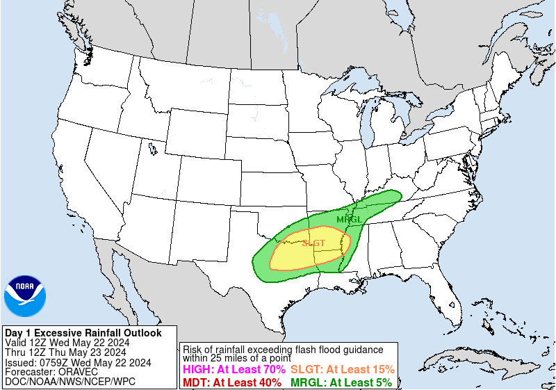
of dumping lots of rain in a short time period, which obviously has the potential to become dangerous if falling across spots that have already been saturated. WPC`s Excessive Rainfall Outlooks from earlier this morning have slight to moderate risks across a large part of Southeast Texas through Wednesday morning, and marginal risks from Wednesday morning through Thursday morning. Since the potential for heavy rainfall still exists, feel it is best to keep our Flash Flood watch up, and have extended it until 7:00 PM Tuesday. Our area`s high precipitable water values do not fall under 2 inches until late on Wednesday or Wednesday night, and that is when we begin to carry slightly lower rain chances in the
forecast. 42
&&
Area Forecast Discussion
National Weather Service Houston/Galveston TX
327 PM CDT Mon Aug 15 2016
.DISCUSSION...
Best shower and thunderstorm coverage this afternoon has been across our far eastern and southeastern locations. These spots, along with the better coverage off to our east, is where the best daytime heating has been taking place. It`s been harder to generate anything stronger then light to occasionally moderate rain further off to the west, but
more development will be possible in these locations if any kind of heating takes place. Forecast is calling for a general trend downward in coverage this evening, followed by increasing coverage near the coast and offshore during the overnight and early morning hours. Precipitable water values remain very high, and storms will continue to be capable
of dumping lots of rain in a short time period, which obviously has the potential to become dangerous if falling across spots that have already been saturated. WPC`s Excessive Rainfall Outlooks from earlier this morning have slight to moderate risks across a large part of Southeast Texas through Wednesday morning, and marginal risks from Wednesday morning through Thursday morning. Since the potential for heavy rainfall still exists, feel it is best to keep our Flash Flood watch up, and have extended it until 7:00 PM Tuesday. Our area`s high precipitable water values do not fall under 2 inches until late on Wednesday or Wednesday night, and that is when we begin to carry slightly lower rain chances in the
forecast. 42
&&
Good luck up there!StormOne wrote:Well, today is my last day here in Houston. Tomorrow, I leave for school in Nebraska. This is really an awesome forum, and every city deserves something like this. I also think that Houston may have the best meteorologists in the country, and I am proud to say that. I will continue to lurk from time to time, and I may even post a thing or two during bad weather events. So long for now!
Do check in from time to time to remind us what weather looks like up in the tundra of Nebraska.

I wonder if we got just enough sun to set off a few things before the overnight sets in....prob 50/50.
-
Texaspirate11

- Posts: 1278
- Joined: Tue Dec 31, 2013 12:24 am
- Contact:
Our FLASH FLOOD WATCH has been extended thru Tuesday night 7 p.m.
Just because you're disabled, you don't have to be a victim
Be Weather Aware & Prepared!
Barbara Jordan Winner in Media
Disability Integration Consultant
Be Weather Aware & Prepared!
Barbara Jordan Winner in Media
Disability Integration Consultant
Yep, and some more storms popping up again with a bit of heading and boundary collisions, especially to the south along the Brazoria/Galveston/Chambers corridor moving inland.
Humble to Kingwood to Porter along 59 is getting rain, trekking this way to the W/NW.
Also, looking at satellite, radar, and the PW maps, it could be a very long and wet night across SE Texas. PW continues to rise as moisture streams north, and there are PW values as high as 2.6" now showing up in the Gulf east of Brownsville.
Also, looking at satellite, radar, and the PW maps, it could be a very long and wet night across SE Texas. PW continues to rise as moisture streams north, and there are PW values as high as 2.6" now showing up in the Gulf east of Brownsville.
Some mischief inside the South Belt and headed NNW. Certainly not caused by 'heat of the day.'
-
Katdaddy

- Global Moderator

- Posts: 2502
- Joined: Thu Feb 04, 2010 8:18 am
- Location: League City, Tx
- Contact:
SPECIAL WEATHER STATEMENT
NATIONAL WEATHER SERVICE HOUSTON/GALVESTON TX
805 PM CDT MON AUG 15 2016
TXZ213-227-237-160145-
BRAZORIA TX-HARRIS TX-FORT BEND TX-
805 PM CDT MON AUG 15 2016
...STRONG THUNDERSTORM ACROSS NORTH CENTRAL BRAZORIA...SOUTH CENTRAL
HARRIS AND NORTHEASTERN FORT BEND COUNTIES THROUGH 845 PM CDT...
AT 804 PM CDT...DOPPLER RADAR WAS TRACKING A STRONG THUNDERSTORM OVER
NORTHERN SIENNA PLANTATION...OR NEAR FRESNO...MOVING NORTHWEST AT 15
MPH. THE STORM WILL PRODUCE LIGHTNING...AND LOCALLY HEAVY DOWNPOURS.
LOCATIONS IMPACTED INCLUDE...
WESTERN PEARLAND...SUGAR LAND...MISSOURI CITY...STAFFORD...
RICHMOND...NORTHWESTERN MANVEL...BUNKER HILL VILLAGE...PINEY POINT
VILLAGE...MISSION BEND...FRESNO...TOWN WEST...PECAN GROVE...FIRST
COLONY...SPRING BRANCH WEST...ELDRIDGE / WEST OAKS...SOUTHEASTERN
ADDICKS PARK TEN...MEADOWS PLACE...ARCOLA...IOWA COLONY AND
THOMPSONS.
PRECAUTIONARY/PREPAREDNESS ACTIONS...
TORRENTIAL RAINFALL IS OCCURRING WITH THIS STORM...AND MAY LEAD TO
LOCALIZED FLOODING. DO NOT DRIVE YOUR VEHICLE THROUGH FLOODED
ROADWAYS.
FREQUENT CLOUD TO GROUND LIGHTNING IS OCCURRING WITH THIS STORM.
LIGHTNING CAN STRIKE 10 MILES AWAY FROM A THUNDERSTORM. SEEK A SAFE
SHELTER INSIDE A BUILDING OR VEHICLE.
Another .64" here since yesterday evening.

Area Forecast Discussion
National Weather Service Houston/Galveston TX
428 AM CDT Tue Aug 16 2016
.DISCUSSION...
A Flash Flood Watch remains in effect for most of SE TX today as
the very wet pattern persists over the region. While a bit lower
than it has been, PWs remaining around 2.2-2.5" today. This com-
bined with the coastal trof/shear axis across the northern zones
and the very low convective temps, we should continue to see the
widespread development of moderate/heavy rains. However, per the
going trends, these storms are moving at a steady pace will this
help in preventing training rains.
Looking ahead, we should continue to see a very slow drop in PWs
over the area as the upper ridge tries to build in from the east.
This is expected to eventually evolve to a more familiar diurnal
pattern of mainly daytime storms by the end of the week. 41
&&
.MARINE...
Winds 15-20 knots over the Gulf waters this morning and have been
gusty with the band of showers and thunderstorms that moved into
the the coastal areas over the last hour or two. Seas of 5-6 feet
should gradually diminish. Winds should relax this morning and by
9 am or so expect winds 10-15 knots. Another round of showers and
thunderstorms should develop overnight as speed convergence
increases and deep moisture remains. Higher winds overnight and
lighter during the day should be the norm through Friday. Tide
levels with the persistent SE flow will likely remain elevated at
around .5 to 1.5 feet above normal through the weekend.
45
&&
.Aviation...
IFR cigs abound across the north and these should continue until the
band of showers and thunderstorms moving north arrives bringing
brief gusty winds and visby restrictions. Daytime heating should
lead to redevelopment this afternoon followed by one more round of
storms coming in off the Gulf in the morning. VFR conditions
should be on tap by around 16-18z.
45
~~~When Thunder Roars Go Indoors~~~
~~~Turn Around Don't Drown~~~
~~~Run From The Water, Hide From The Wind~~~
~~~Turn Around Don't Drown~~~
~~~Run From The Water, Hide From The Wind~~~
~~~When Thunder Roars Go Indoors~~~
~~~Turn Around Don't Drown~~~
~~~Run From The Water, Hide From The Wind~~~
~~~Turn Around Don't Drown~~~
~~~Run From The Water, Hide From The Wind~~~
-
Katdaddy
- Global Moderator
- Posts: 2502
- Joined: Thu Feb 04, 2010 8:18 am
- Location: League City, Tx
- Contact:
Flash Flood Watch continues today but rain chances should begin to slowly decrease through the rest of the week. 33 year's ago today I was continuing to watch TS Alicia in the NGOM steadily increase in strength. By the end of the day Tuesday August 16th the maximum sustained winds had increased from 50MPH to 70MPH. My first hurricane experience was on the way for Wednesday night and Thursday morning.
- Attachments
-
I certainly remember Alicia nice post.

-
CrashTestDummy
- Posts: 187
- Joined: Mon Jul 25, 2016 3:44 pm
- Location: Pearland, Texas
- Contact:
Alicia was also my first hurricane experience. Interesting that it formed from a low just off the Miss. coast!
We still have the generator my Dad purchased after that storm.
Imagine that taping up windows was _the_ thing to do back then. I did, however, help board up the front windows of the building I worked at the day before it hit. A friend and I had a 'hurricane party' parked in the parking lot of that business, enjoying a few brewskies. We ran out, the stores were all closed, so we went home before really hard winds hit.
The next morning, when I could get out of my subdivision, I went to work. The store's sign, which was mounted on 4 telephone poles, was laying in the parking lot where we parked. The poles were sheered off at the ground.
Gene Beaird,
Pearland, Texas
"You can learn a lot from a Dummy."
Pearland, Texas
"You can learn a lot from a Dummy."
Area Forecast Discussion
National Weather Service Houston/Galveston TX
1048 AM CDT Tue Aug 16 2016
.DISCUSSION...
Rounds of showers and thunderstorms are continuing to develop and move
at a pretty good speed generally to the north this morning. Moderate
to heavy rainfall is occuring mainly along the leading edge of these
storms with rainfall rates close to 2 to 4 inches per hour. We have
come close to issuing Flood Advisories for some spots in and around
the Houston area where rainfall totals have been over 1 inch. If the
next round of storms to the south of the area holds together, Flood
Advisories will be needed. Moisture levels remain high, and the latest
WPC Day 1 Excessive Rainfall Outlook keeps the slight risk across our
entire area through tonight. With the heavy rainfall threat still
persisting, see no reason to remove the Flash Flood Watch at this time.
42
&&
-
Katdaddy
- Global Moderator
- Posts: 2502
- Joined: Thu Feb 04, 2010 8:18 am
- Location: League City, Tx
- Contact:
NATIONAL WEATHER SERVICE HOUSTON/GALVESTON TX
1150 AM CDT TUE AUG 16 2016
TXC201-339-161945-
/O.NEW.KHGX.FA.Y.0176.160816T1650Z-160816T1945Z/
/00000.N.ER.000000T0000Z.000000T0000Z.000000T0000Z.OO/
HARRIS TX-MONTGOMERY TX-
1150 AM CDT TUE AUG 16 2016
THE NATIONAL WEATHER SERVICE IN LEAGUE CITY HAS ISSUED A
* FLOOD ADVISORY FOR...
HARRIS COUNTY IN SOUTHEASTERN TEXAS...
SOUTHEASTERN MONTGOMERY COUNTY IN SOUTHEASTERN TEXAS...
* UNTIL 245 PM CDT
* AT 1148 AM CDT...DOPPLER RADAR AND AUTOMATED RAIN GAUGES INDICATED
HEAVY RAIN DUE TO SHOWERS AND THUNDERSTORMS. THIS WILL CAUSE MINOR
FLOODING IN THE ADVISORY AREA. RAINFALL TOTALS OF 1.00 TO 1.50
INCHES HAVE ALREADY FALLEN...AND AN ADDITIONAL 1 TO 2 INCHES WILL
BE POSSIBLE AS ACTIVITY MOVES NORTHWARD ACROSS THE AREA OVER THE
NEXT SEVERAL HOURS.
* SOME LOCATIONS THAT MAY EXPERIENCE FLOODING INCLUDE...
PASADENA...BAYTOWN...LA PORTE...DEER PARK...SOUTH HOUSTON...
BELLAIRE...HUMBLE...WEST UNIVERSITY PLACE...SEABROOK...GALENA
PARK...JACINTO CITY...ASTRODOME AREA...BARRETT...GREATER FIFTH
WARD...NEARTOWN / MONTROSE...SECOND WARD...GREATER HOBBY AREA...
NEAR NORTHSIDE HOUSTON...GREENWAY / UPPER KIRBY AREA AND SPRING.
PRECAUTIONARY/PREPAREDNESS ACTIONS...
TURN AROUND...DON`T DROWN WHEN ENCOUNTERING FLOODED ROADS. MOST FLOOD
DEATHS OCCUR IN VEHICLES.
PLEASE REPORT FLOODING TO YOUR LOCAL LAW ENFORCEMENT AGENCY WHEN YOU
CAN DO SO SAFELY.
A FLOOD ADVISORY MEANS RIVER OR STREAM FLOWS ARE ELEVATED...OR
PONDING OF WATER IN URBAN OR OTHER AREAS IS OCCURRING OR IS IMMINENT.
1150 AM CDT TUE AUG 16 2016
TXC201-339-161945-
/O.NEW.KHGX.FA.Y.0176.160816T1650Z-160816T1945Z/
/00000.N.ER.000000T0000Z.000000T0000Z.000000T0000Z.OO/
HARRIS TX-MONTGOMERY TX-
1150 AM CDT TUE AUG 16 2016
THE NATIONAL WEATHER SERVICE IN LEAGUE CITY HAS ISSUED A
* FLOOD ADVISORY FOR...
HARRIS COUNTY IN SOUTHEASTERN TEXAS...
SOUTHEASTERN MONTGOMERY COUNTY IN SOUTHEASTERN TEXAS...
* UNTIL 245 PM CDT
* AT 1148 AM CDT...DOPPLER RADAR AND AUTOMATED RAIN GAUGES INDICATED
HEAVY RAIN DUE TO SHOWERS AND THUNDERSTORMS. THIS WILL CAUSE MINOR
FLOODING IN THE ADVISORY AREA. RAINFALL TOTALS OF 1.00 TO 1.50
INCHES HAVE ALREADY FALLEN...AND AN ADDITIONAL 1 TO 2 INCHES WILL
BE POSSIBLE AS ACTIVITY MOVES NORTHWARD ACROSS THE AREA OVER THE
NEXT SEVERAL HOURS.
* SOME LOCATIONS THAT MAY EXPERIENCE FLOODING INCLUDE...
PASADENA...BAYTOWN...LA PORTE...DEER PARK...SOUTH HOUSTON...
BELLAIRE...HUMBLE...WEST UNIVERSITY PLACE...SEABROOK...GALENA
PARK...JACINTO CITY...ASTRODOME AREA...BARRETT...GREATER FIFTH
WARD...NEARTOWN / MONTROSE...SECOND WARD...GREATER HOBBY AREA...
NEAR NORTHSIDE HOUSTON...GREENWAY / UPPER KIRBY AREA AND SPRING.
PRECAUTIONARY/PREPAREDNESS ACTIONS...
TURN AROUND...DON`T DROWN WHEN ENCOUNTERING FLOODED ROADS. MOST FLOOD
DEATHS OCCUR IN VEHICLES.
PLEASE REPORT FLOODING TO YOUR LOCAL LAW ENFORCEMENT AGENCY WHEN YOU
CAN DO SO SAFELY.
A FLOOD ADVISORY MEANS RIVER OR STREAM FLOWS ARE ELEVATED...OR
PONDING OF WATER IN URBAN OR OTHER AREAS IS OCCURRING OR IS IMMINENT.
-
Katdaddy
- Global Moderator
- Posts: 2502
- Joined: Thu Feb 04, 2010 8:18 am
- Location: League City, Tx
- Contact:
The Houston-Galveston NWS extends the Flash Flood Watch through Wednesday until 7PM.
FLOOD WATCH
NATIONAL WEATHER SERVICE HOUSTON/GALVESTON TX
324 PM CDT TUE AUG 16 2016
TXZ177>179-195-197>200-210>214-226-227-235>238-180000-
/O.EXT.KHGX.FF.A.0008.000000T0000Z-160818T0000Z/
/00000.0.ER.000000T0000Z.000000T0000Z.000000T0000Z.OO/
AUSTIN-BRAZORIA-BURLESON-CHAMBERS-COLORADO-FORT BEND-GALVESTON-
GRIMES-HARRIS-JACKSON-LIBERTY-MATAGORDA-MONTGOMERY-POLK-
SAN JACINTO-WALKER-WALLER-WASHINGTON-WHARTON-
INCLUDING THE CITIES OF...ALVIN...ANAHUAC...ANGLETON...BAY CITY...
BELLVILLE...BRENHAM...BROOKSHIRE...CALDWELL...CLEVELAND...
COLDSPRING...COLUMBUS...CONROE...CORRIGAN...DAYTON...EAGLE LAKE...
EDNA...EL CAMPO...FREEPORT...FRIENDSWOOD...GALVESTON...
HEMPSTEAD...HOUSTON...HUMBLE...HUNTSVILLE...KATY...LAKE JACKSON...
LAKE SOMERVILLE...LEAGUE CITY...LIBERTY...LIVINGSTON...
MISSOURI CITY...MONT BELVIEU...NAVASOTA...ONALASKA...PALACIOS...
PASADENA...PEARLAND...PIERCE...PRAIRIE VIEW...RICHMOND...
ROSENBERG...SEALY...SHEPHERD...SUGAR LAND...TEXAS CITY...
THE WOODLANDS...TOMBALL...WEIMAR...WHARTON...WILLIS...WINNIE
324 PM CDT TUE AUG 16 2016
...FLASH FLOOD WATCH NOW IN EFFECT THROUGH WEDNESDAY EVENING...
THE FLASH FLOOD WATCH IS NOW IN EFFECT FOR
* PORTIONS OF SOUTHEAST TEXAS AND SOUTHEAST TEXAS...INCLUDING THE
FOLLOWING JACKSON....AUSTIN...BRAZORIA...BURLESON...
CHAMBERS...COLORADO...FORT ...BEND...GALVESTON...GRIMES...
HARRIS...LIBERTY...MATAGORDA...MONTGOMERY...POLK...SAN
JACINTO...WALKER...WALLER...WASHINGTON AND WHARTON.
* THROUGH WEDNESDAY EVENING
* RAINFALL TOTALS CONTINUE TO ADD UP ACROSS PARTS OF SOUTHEAST
TEXAS. THROUGH WEDNESDAY EVENING...EXPECT TO SEE MORE ROUNDS OF
SHOWERS AND THUNDERSTORMS PRODUCING A WIDE RANGES OF TOTALS
ACROSS THE AREA. WITH DEEP TROPICAL MOISTURE REMAINING IN
PLACE...STRONGER SHOWERS AND THUNDERSTORMS COULD PRODUCE
LOCALIZED 3 TO 5 INCH AMOUNTS IN A SHORT PERIOD OF TIME.
EXCESSIVE RAINFALL FALLING OVER GROUNDS THAT MAY ALREADY BE
SATURATED WILL QUICKLY RUNOFF AND COULD LEAD TO FLASH FLOODING.
* THESE HIGH RAINFALL RATES CAN LEAD TO STREET FLOODING...
ESPECIALLY WHEN FALLING ON ALREADY SATURATED GROUNDS. AREA
CREEKS...BAYOUS...AND RIVERS WILL ALSO NEED TO BE MONITORED FOR
RISES NEAR LOCATIONS THAT RECEIVE EXCESSIVE RAINFALL.
PRECAUTIONARY/PREPAREDNESS ACTIONS...
A FLASH FLOOD WATCH MEANS THAT CONDITIONS MAY DEVELOP THAT LEAD
TO FLASH FLOODING. FLASH FLOODING IS A VERY DANGEROUS SITUATION.
BE ESPECIALLY CAUTIOUS AT NIGHT WHEN IT IS HARDER TO RECOGNIZE
THE DANGERS OF FLOODING.
YOU SHOULD MONITOR LATER FORECASTS AND BE PREPARED TO TAKE ACTION
SHOULD FLASH FLOOD WARNINGS BE ISSUED.