April 2016 Recap: Regional Flood/Severe Weather

General Weather Discussions and Analysis
Post Reply
User avatar
srainhoutx
Site Admin
Site Admin
Posts: 19616
Joined: Tue Feb 02, 2010 2:32 pm
Location: Maggie Valley, NC
Contact:

Morning briefing from Jeff:

***Major storm system to impact TX Saturday-Tuesday***

***Significant rainfall, flash flooding, river flooding, severe weather increasingly likely***

Discussion:
Developing upper level storm system currently over the NW Rockies will drift southward into the SW US while increasing in intensity. Sub-tropical jet stream is clearly seen arcing through MX this morning and the position of the upper level system by late Saturday over NM will place much of TX in a highly favorable divergent upper air pattern. Moisture will begin to increase from the Gulf of Mexico today out west and in across SE TX on Saturday. Models are coming into fairly good agreement on a period of sustained lift from late Sunday into much of Monday and even Tuesday as the very slow moving upper level storm drifts across TX. Also starting to see better indications of a stalled surface trough or even frontal boundary in the mix which will really help to focus the rainfall. Moisture levels by late Sunday at near climo maximums for this time of year with PWS pushing 2.0 inches. This combined with the strong dynamics aloft and hour after hour of sustained lift is very concerning for the potential for prolonged cell training of excessive rainfall.

Can’t rule out fast moving S to N showers on Saturday, but think much of the day will be mostly cloudy and breezy as moisture increases. Strong short wave rotating around the upper level system into the Big Bend region Saturday evening and into C TX early Sunday looks like the trigger to set things off to our west that then slowly move into our area on Sunday. Would not be surprised to see this slowed down a little more with such a slow moving storm system

Rainfall:
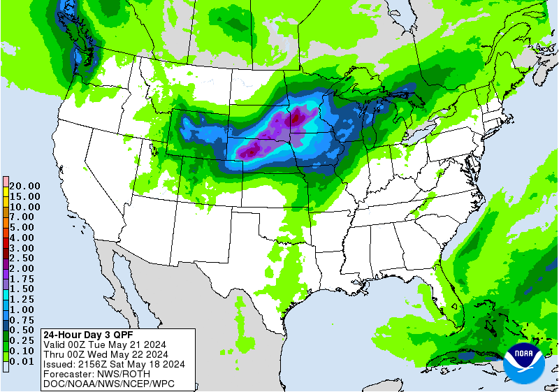
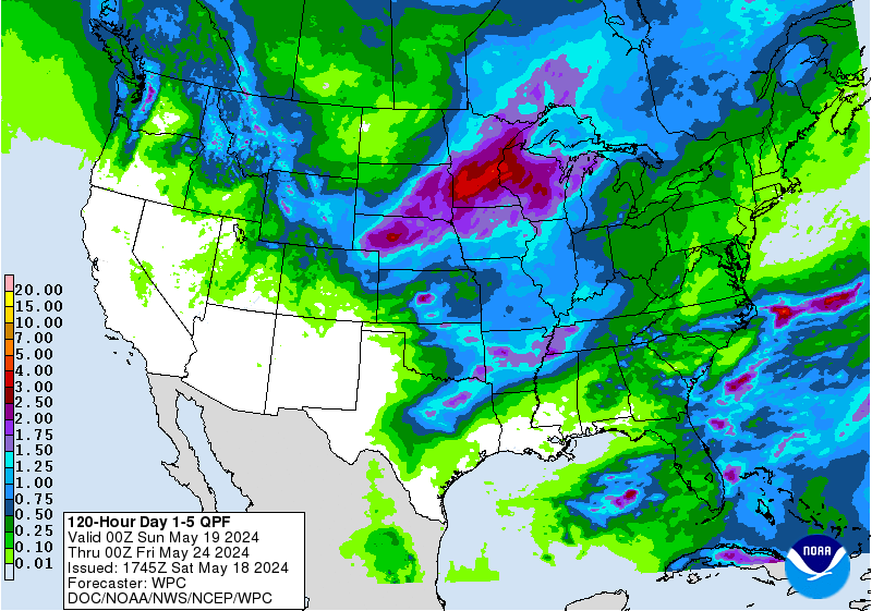
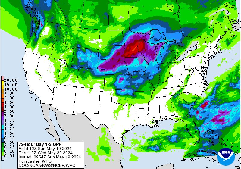
Starting to feel more confident in widespread big totals across not only SE TX, but much of C and N TX. Will broadbrush amounts of 3-5 inches widespread across nearly all of C, N, and E TX with several locations of isolated totals greater than 6-8 inches. Really hard to attempt to pin point that upper bound with such a favorable set up and prolonged event. Would not at all be surprised for a few isolated locations to see 12 inches or more of rainfall. QPF “bullseye” has shifted more SE into SE TX over the last 24 hrs and this trend is concerning. Where any training establishes is where some really big totals will be likely along with a significant flash flood threat. Think the greatest threat period will be late Sunday afternoon-Tuesday for SE TX.

Hydro:
Widespread prolonged nature of the event with large areas of high QPF is very worrying for area rivers which are still in recovery from the early March rains. Flood control lakes are in the process of evacuating their remaining flood pools, but there is a large amount of above normal water within many of the river systems over eastern TX and most are running well above base flow. Grounds are not soggy, but they are not dry which will only add to the run-off. Think all river basins over SE TX from the Guadalupe to the SW to the Sabine in the east are in play with this event and current forecasted rainfall amounts would bring many likely to or above flood stage. Based on current QPF patterns I am getting very worried about the Brazos and Navasota Basins with nearly 5-7 inches of QPF across almost the entire basins over a 2-4 day period. That is a tremendous amount of water to be forced on those systems.

Severe:
Starting to see a few more parameters for severe weather Sunday-Monday with better instability. Think main threats will be damaging wind gusts with hail and tornadoes secondary. This still does not look like a big severe weather event, but can’t rule out small scale bow echoes or wind damage along any organized convective system coming out of C TX. The flash flood threat continues to be the primary threat.

5-Day QPF (Rainfall)
04152016 Jeff 1 unnamed.gif
Actions:
Persons with outdoor plans this weekend, especially Sunday, should be fully aware of the threat for rapidly changing weather conditions. Persons across C TX should be fully aware of the potential for flash flooding along creeks and rivers and make sure cell phone weather ALERTS are enabled on their phone, especially for anyone planning to be near any of those river basins. One of the biggest lessons learned from the Blanco River/Wimberley Flood last year was that warning were out, but residents in danger were not getting those warnings.
Carla/Alicia/Jerry(In The Eye)/Michelle/Charley/Ivan/Dennis/Katrina/Rita/Wilma/Humberto/Ike/Harvey

Member: National Weather Association
Facebook.com/Weather Infinity
Twitter @WeatherInfinity
User avatar
srainhoutx
Site Admin
Site Admin
Posts: 19616
Joined: Tue Feb 02, 2010 2:32 pm
Location: Maggie Valley, NC
Contact:

The 12Z GFS suggests some very impressive rainfall totals through Wednesday across our region. We will need to monitor the guidance over the weekend to fine tune the possibility of a heavy rainfall event across portions of Central and SE Texas. The Texas Coastal NWS Forecasters that are attending the National Tropical Weather Conference as well as Media and our State Government partners are monitoring the evolving sensible weather pattern ahead and we will continue to update over the weekend.
Attachments
gfs_apcpn_scus_22.png
Carla/Alicia/Jerry(In The Eye)/Michelle/Charley/Ivan/Dennis/Katrina/Rita/Wilma/Humberto/Ike/Harvey

Member: National Weather Association
Facebook.com/Weather Infinity
Twitter @WeatherInfinity
Andrew
Site Admin
Site Admin
Posts: 3440
Joined: Wed Feb 03, 2010 9:46 pm
Location: North-West Houston
Contact:

Heaviest rain will setup along the axis of surface/low level low that forms. Currently the GFS has this tracking right across the northern extent of SE Texas and as a result we see ~13 inches in those regions. Pwats are up to 2+inches late Sunday into Monday as a strong low level flow brings a large fetch of moisture from deep in the gulf. Biggest issue is going to be training as the mean flow supports a NE movement, but with a slow overall southern movement. I would expect a FFW to be issued in the coming days as confidence and consensus is growing that this will likely be a flooding event for a large part of the state.
For Your Infinite Source For All Things Weather Visit Our Facebook
User avatar
sambucol
Posts: 1047
Joined: Wed Feb 03, 2010 5:43 pm
Location: Mont Belvieu
Contact:

How does this affect Liberty? I've a friend whose property was flooded last October. Does this event look like the one from October or is it worse? Thanks.
User avatar
jasons2k
Posts: 5402
Joined: Thu Feb 04, 2010 12:54 pm
Location: Imperial Oaks
Contact:

Well, what's interesting is that the Euro happens to show the heaviest rainfall axis a bit further east, with the bullseye right over Liberty County with 13 inches through Wednesday.
Andrew
Site Admin
Site Admin
Posts: 3440
Joined: Wed Feb 03, 2010 9:46 pm
Location: North-West Houston
Contact:

Flash flood watches issued for NW parts of the state. Should see that trend continue Southeastward as we head into Saturday.
Attachments
Screen Shot 2016-04-15 at 3.53.25 PM.png
For Your Infinite Source For All Things Weather Visit Our Facebook
User avatar
DoctorMu
Posts: 5698
Joined: Sun Jun 28, 2015 11:58 am
Location: College Station
Contact:

Yuuuuge.

Image

Given the confidence of the omega block, there will be wetness. 10-13 in from Temple to Houston
User avatar
DoctorMu
Posts: 5698
Joined: Sun Jun 28, 2015 11:58 am
Location: College Station
Contact:

GPS has the firehose continuing until May. :ugeek:

Image
User avatar
jasons2k
Posts: 5402
Joined: Thu Feb 04, 2010 12:54 pm
Location: Imperial Oaks
Contact:

Good Discussion from NWS - Houston/Galveston:
.LONG TERM /SUNDAY THROUGH THURSDAY/...
THE MAIN FOCUS FOR THE LONG TERM PORTION OF THE FORECAST CONTINUES
TO BE THE POTENTIAL FOR HEAVY RAIN AND SEVERE WEATHER TO OCCUR
ACROSS PORTIONS OF SOUTHEAST TEXAS. AS THE UPPER LOW NOW NEAR THE
FOUR CORNERS NUDGES FARTHER EAST TOWARDS TEXAS ON SUNDAY... IT
WILL PUSH THE UPPER RIDGE OVER THE REGION FARTHER INTO THE GULF.
THIS WILL RESULT IN INCREASINGLY DIFFLUENT FLOW ALOFT ACROSS THE
NORTHERN AND NORTHWESTERN COUNTIES AND ALLOW SCATTERED TO NUMEROUS
SHOWERS AND THUNDERSTORMS TO DEVELOP ACROSS THE REGION.

FORECAST SOUNDINGS NEAR COLLEGE STATION AND HOUSTON SHOW PRECIPITABLE
WATER VALUES RISING TO NEAR 1.8 TO 1.9 INCHES /ALMOST RECORD
VALUES FOR THIS TIME OF YEAR/ AS WELL AS CURVED HODOGRAPHS...
MLCAPE VALUES EXCEEDING 1000 J/KG... AND MID LEVEL LAPSE RATES
APPROACHING 7 C/KM. WITH THE BEST LIFT FOCUSING ACROSS THE
NORTHERN AND NORTHWESTERN AREAS SUNDAY AFTERNOON AND NIGHT...
THINK THE GREATEST POTENTIAL FOR HEAVY RAINFALL WILL RESIDE OVER
THESE AREAS. HOWEVER... ENVIRONMENTAL CONDITIONS WILL BE FAVORABLE
FOR ISOLATED TORNADOES... DAMAGING WINDS... AND POSSIBLY SOME HAIL
ACROSS MOST OF THE REGION SUNDAY AFTERNOON INTO MONDAY MORNING.

BY MONDAY... THE UPPER LOW BEGINS TO LIFT ACROSS THE SOUTHERN
PLAINS AND DIFFLUENT FLOW SHIFTS FARTHER SOUTH ACROSS THE REGION.
AT THE SAME TIME... A COLD FRONT MAKES ITS WAY TOWARDS THE REGION
BUT LOOKS TO WASH OUT SOMEWHERE ACROSS CENTRAL TEXAS BY EARLY
TUESDAY MORNING. MODEL GUIDANCE HAS CONSISTENTLY SHOWN FORECAST
RAIN TOTALS IN EXCESS OF 9-10 INCHES ACROSS PORTIONS OF THE REGION
DURING THE MONDAY/TUESDAY TIMEFRAME... WITH VARYING LOCATIONS FOR
THESE QPF BULLSEYES. SOME OF THESE BULLSEYES HAVE BEEN ALONG THE
STALLED FRONT OR AS THE RESULT OF A DEVELOPING THUNDERSTORM
COMPLEX. THE 12Z DETERMINISTIC GFS PAINTS A SWATH OF 13 INCH
AMOUNTS ACROSS THE BRAZOS VALLEY... A SOLUTION WHICH EXCEEDS ALL
OF ITS ENSEMBLE MEMBERS BY ALMOST 3 INCHES. THIS IS LIKELY DUE TO
THE DETERMINISTIC GFS ATTEMPTING TO RESOLVE/DEVELOP SOME KIND OF
MESOSCALE THUNDERSTORM COMPLEX BUT BECAUSE OF ITS RESOLUTION IS
DOING SO POORLY. ADDING TO SUPPORT OF THIS POSSIBILITY... THE
PAST THREE RUNS OF THE GFS HAVE SHOWN SOME KIND OF
SHORTWAVE/ RIPPLE IN THE FLOW ALOFT THAT IS LIKELY BEING
GENERATED BY THIS ATTEMPT TO RESOLVE CONVECTION. THE EUROPEAN ALSO
DISPLAYS A SIMILAR FEATURE SUNDAY NIGHT INTO MONDAY BUT IS MUCH
WEAKER.

THE MAIN TAKEAWAY FROM THIS IS NOT TO FOCUS SO MUCH ON THE RANDOM
BULLSEYES EACH MODEL IS GENERATING AS THEY DIFFER BOTH SPATIALLY
AND TEMPORALLY... BUT THAT THERE IS CONSISTENCY IN BOTH MODELS IN
ATTEMPTING TO DEVELOP A MESOSCALE FEATURE CAPABLE OF HEAVY
RAINFALL NEAR THE REGION SOMETIME SUNDAY NIGHT THROUGH TUESDAY
MORNING. THIS INCREASES CONFIDENCE IN A HEAVY RAIN EPISODE
AFFECTING PORTIONS OF CENTRAL/EASTERN TEXAS... BUT HOW MUCH AND
WHICH AREAS WILL BE DEFINED BY WHERE SMALLER SCALE FEATURES /WHICH
THE MODELS CANNOT RESOLVE THIS FAR OUT/ ARE LOCATED WHEN THE EVENT
ACTUALLY BEGINS.
FOR NOW... HIGHLIGHTING AREAS ALONG AND NORTH OF
THE HIGHWAY 59 CORRIDOR THROUGH TUESDAY AS HAVING THE GREATEST
POTENTIAL TO SEE HEAVY RAIN BUT THIS WILL NEED TO BE REFINED IN
FUTURE FORECASTS.

THE MAIN TIME PERIOD OF CONCERN FOR HEAVY RAIN AND SEVERE WEATHER
FOR THE REGION EXISTS SUNDAY THROUGH TUESDAY... BUT SHOWERS AND
THUNDERSTORMS WILL LINGER THROUGH THURSDAY AS THE UPPER LOW
SHEARS OUT OVER THE SOUTHERN PLAINS AS IT SLOWLY PUSHES EAST.
User avatar
DoctorMu
Posts: 5698
Joined: Sun Jun 28, 2015 11:58 am
Location: College Station
Contact:

While the bullseye has shifted as expected per iteration, the magnitude of the hottest spot is about 15 in of rain over La Grange (home of ZZ Top) and 7+ in of rain cover an area nearly 2/3 the size of West Virginia. College Station, Houston, Victoria, and Austin within the confines.

Image
Andrew
Site Admin
Site Admin
Posts: 3440
Joined: Wed Feb 03, 2010 9:46 pm
Location: North-West Houston
Contact:

GFS is still going strong on an area between Austin to College Station and back down to Houston.
Attachments
qpf_acc.us_sc (1).png
For Your Infinite Source For All Things Weather Visit Our Facebook
unome
Posts: 3059
Joined: Fri Feb 12, 2010 6:11 pm

from the latest QPF discussion, snippet from day 3 (full disco is very long) http://www.wpc.ncep.noaa.gov/discussion ... isc=qpfpfd

during day 3... the low level boundary starts moving east across the southern plains... and the boundary remains the focus for heavy rainfall. there is an increasing amount of spread concerning where the highest qpf amounts occur across east central tx... since there are timing/placement differences with a short wave that crosses the boundary. ahead of the front and short wave... the low level inflow supports transporting precipitable water values between 1.75 and 2.00 inches (which is between two and three standard deviations above the mean)... as well as moderate instability.

a large area of 3.00 to 5.00 inches of qpf was placed over east central tx... closest in placement to the 00z gfs placement (though with not nearly the magnitude...as the 00z gfs showed over 14 inches of qpf here). most of the 00z guidance shows between 5 and 10 inches of qpf somewhere in east central tx... with the 00z ecmwf furthest east... and the 00z nam furthest west. a moderate risk area was placed near the bullseye... to highlight the potential for what could be a big qpf event during day 3. this was surrounded by a larger slight risk area... to acknowledge the spread in the guidance.

Day 3 QPF (as discussed above)
Image
Last edited by unome on Sat Apr 16, 2016 6:29 am, edited 1 time in total.
unome
Posts: 3059
Joined: Fri Feb 12, 2010 6:11 pm

looks like WGRFC and HCFCD will be working long hours from HGX morning discussion http://forecast.weather.gov/product.php ... glossary=0

the concern for heavy rainfall and flooding really increases monday night into tuesday. precip water value increase to 2 inches again. to put in perspective... this would be above 2 standard deviations and 99th percentile. the naefs percentile is actually 99.5 percent for 06z tuesday when both the gfs and ecmwf produce large amounts of precipitation on the order of 6 to 9 inches. in addition to the high amounts of moisture... there should be an abundance of outflow boundaries for convective development and anywhere from 20 to 40 knots of flow from the gulf at 925-850mb. it looks like monday night into tuesday will need to be watched very closely for very heavy rainfall and flooding. a flash flood watch will likely be needed but may depend upon antecedent rainfall from convection sunday night. rainfall amounts are very difficult to determine in this kind of environment and we really need not focus on one particular model run for those amounts. based on the last several gfs and ecmwf model runs...there could be upwards of 10 inches of rainfall. area wide 4 to 8 inches looks reasonable at this point but the isolated higher amounts could be borderline statistical outliers that should not be ignored. adding in the possible rainfall amounts from sunday night into monday... area wide rainfall totals could approach 5 to 10 inches or more. this would lead to a significant flood event for southeast texas that really has not see much rainfall so far this year. wpc even drives this point home with a moderate risk of excessive rainfall over much of se texas in its day 3 outlook which could be upgraded in future outlooks.

the last part of this forecast challenge is where exactly the heavy rainfall will occur. that will largely depend on mesoscale boundaries from prior convection from sunday and monday. models are really focusing on areas west of i-45 at this point starting towards c texas and moving into college station monday night. heavy rainfall then could move se which matches up well with upwind corfidi vectors should there be a maintained mcs producing the heavy rainfall. this would affect houston late monday night into tuesday morning. reality is that we are just not that good yet to determine exact locations of heavy rainfall but safe to say that a good portion of se texas could be affected


5-day QPF
Image
User avatar
srainhoutx
Site Admin
Site Admin
Posts: 19616
Joined: Tue Feb 02, 2010 2:32 pm
Location: Maggie Valley, NC
Contact:

Saturday morning briefing from Jeff:

***Major high impact storm system heading for TX***

***Significant flash flood and river flood threat***

Discussion:
Powerful upper level storm system has moved into the SW US and is slowing down as expected as high pressure over the eastern Gulf pushes up against this feature. Low level winds have turned SE overnight and the moisture pump will get going today across the region. Expect breezy conditions with isolated showers this afternoon. Upper low edges east on Sunday toward NM/W TX with the upper air pattern over TX becoming increasing divergent aloft. Moisture levels soar into the 1.8-2.0 inch range of PW which is very high for mid April.

Expect numerous thunderstorms to develop Sunday afternoon along I-35 from Austin to Dallas and then slowly develop into a slow moving MCS that moves into and across SE TX Monday and Monday night. Latest GFS and ECMWF hammer the area on Monday and Monday night with tremendous rainfall amounts. It would appear that most if not all factors are in place for a significant flash flood event: numerous low level boundaries, slow moving upper level low, strong moisture feed off the Gulf, near record moisture levels, strongly divergent upper air winds, and upper winds parallel to the low level boundaries.

Rainfall Amounts:

The GFS and ECMWF have tremendous rainfall over much of SE TX including Harris County late Sunday-Tuesday. Latest GFS has widespread 6-10 inches with a maximum of 14 inches near LaGrange, TX and is producing 8.28 inches at IAH Monday and Monday night. This model has been showing similar totals since late Thursday so confidence is growing in this solution. The ECMWF shows widespread 6-8 inches over much of the region with isolated totals near 13 inches.

Will bump up the widespread amounts for SE TX into the 4-6 inches range with isolated amounts of 8 inches. This is still lower than much of the model guidance and even what WPC is placing over the area, but there is still some uncertainty on where the training is going to set up. It may in fact be several different areas of cell training which produce several areas of large rainfall.

TX TECH 3km meso model is just starting to reach into the range of late Sunday and does show what the big global models have been indicating with a slow moving large thunderstorm complex near Waco to College Station…but the model time period ends before one is able to see how it all plays out over SE TX. This does give more confidence that the global models are on the right track.

Hydro:

Very concerned for the Brazos, Colorado, and Navasota Basins, but all our rivers are in play. With the rainfall QPF amounts starting to aim strongly at the Brazos River below the flood control capabilities at Waco almost all of what falls will go uncontrolled into the main stem river. Nearly the entire middle basin is hit with widespread 5-10 inches of rainfall. USACE flood control capabilities at Lake Somerville will help some, but the forecasted amounts would almost certainly lead to major flooding of the Navasota and lower Brazos basins.

Widespread amounts of 4-6 inches over the San Jacinto and San Bernard basins including the Harris County bayous may also lead to significant rises. Isolated higher totals are possible over these basins which would likely push them into flood.

Severe:
Threat remains from late Sunday-early Tuesday with good shear and modest instability in place over the region. All severe modes will be possible with large hail being the least likely in such a tropical air mass. Will need to watch any low level boundary that becomes W to E oriented against the low level inflow as any supercells along such a feature could have a higher tornado threat.

5-Day QPF:
04162016 Jeff 1.gif
Carla/Alicia/Jerry(In The Eye)/Michelle/Charley/Ivan/Dennis/Katrina/Rita/Wilma/Humberto/Ike/Harvey

Member: National Weather Association
Facebook.com/Weather Infinity
Twitter @WeatherInfinity
Andrew
Site Admin
Site Admin
Posts: 3440
Joined: Wed Feb 03, 2010 9:46 pm
Location: North-West Houston
Contact:

GFS continues to target the same area and the biggest concern for rain looks to occur during the Monday night Tuesday morning timeframe as the heaviest and slowest convection occurs. That will be when the highest flash flooding threat will take place.
Attachments
qpf_acc.us_sc (2).png
For Your Infinite Source For All Things Weather Visit Our Facebook
unome
Posts: 3059
Joined: Fri Feb 12, 2010 6:11 pm

SPC's updated day 2 http://www.spc.noaa.gov/products/outlook/day2otlk.html

snippet:

...portions of the srn plains...
at the beginning of the period...convective clusters -- perhaps organized as quasi-linear segments -- will likely be ongoing invof the i-35 corridor in ok extending swwd into parts of n-cntrl/cntrl/sw tx. through the period...the aforementioned smaller-scale perturbations will be associated with sufficient ascent for this activity to slowly edge ewd...with additional convection developing swd within the warm sector toward/across parts of cntrl/srn tx.

a more-modified gulf air mass -- characterized by sfc dewpoints from the middle 60s to the lower 70s -- will be confined to portions of cntrl/srn tx supporting mlcape around 1000-1750 j/kg... with weaker instability farther n. with limited capping... multiple convective clusters will likely spread ewd/newd through the period within the warm sector. sswly to swly mid-level flow around 25-35 kt... coupled with enhanced low-level shear attendant to 30-40-kt slys/sselys at h85... will support organized multicell clusters... and perhaps transient supercell structures... with locally dmgg wind gusts... marginally svr hail... and perhaps a brief tornado or two. the greatest potential for this activity will exist within the slgt-risk area... which could linger into sunday night as additional mid-level perturbations graze the wrn extent of returning moisture/related buoyancy.

however... the overall tendency for the mid/upper-level cyclone to be weakening while transitioning toward an equivalent-barotropic structure suggests that deep ascent will be limited over the warm/moist sector. furthermore...stronger mid-level flow/deep shear will be displaced to the w/nw of the greater instability... while mid-level lapse rates surmounting the warm/moist air will be modest -- partly owing to antecedent convective processing in some areas. for these reasons... a greater svr risk is not anticipated.
Last edited by unome on Fri Apr 22, 2016 7:13 am, edited 1 time in total.
User avatar
jasons2k
Posts: 5402
Joined: Thu Feb 04, 2010 12:54 pm
Location: Imperial Oaks
Contact:

The GFS still has the biggest bullseye just to the west (Columbus to Bellville) with 18", and another one down south in Galveston/Brazoria counties. The Euro is just insane crazy with two 8-10" bullseyes W and NW of Houston, but the mother lode is in SE Polk County with over 25"! Let's hope those do not verify - that would be incredible flooding.
User avatar
DoctorMu
Posts: 5698
Joined: Sun Jun 28, 2015 11:58 am
Location: College Station
Contact:

jasons wrote:The GFS still has the biggest bullseye just to the west (Columbus to Bellville) with 18", and another one down south in Galveston/Brazoria counties. The Euro is just insane crazy with two 8-10" bullseyes W and NW of Houston, but the mother lode is in SE Polk County with over 25"! Let's hope those do not verify - that would be incredible flooding.
off the hook

Image

We won't be able to completely pinpoint where entraining will drop those mother loads of rain, but too many models agreeing on epic-ness. Take all precautions.
unome
Posts: 3059
Joined: Fri Feb 12, 2010 6:11 pm

Short Range Forecast Discussion
NWS Weather Prediction Center College Park MD
345 PM EDT Sat Apr 16 2016

Valid 00Z Sun Apr 17 2016 - 00Z Tue Apr 19 2016

...There is a slight risk of severe thunderstorms over the Southern High Plains...

...Heavy rain possible from parts of the Northern Plains to the Southern Plains...

...Heavy snow possible over parts of the Central Rockies and parts of the Northern/Central High Plains...

A deep upper-level low will be generally be stalled over the Southern/Central Rockies through Monday. Likewise, an associated front will be quasi-stationary from the Upper Midwest southward to the Southern Plains. Moisture from the Gulf of Mexico will flow northward over the Plains along and near the boundary. Showers and thunderstorms will develop along and near the front over the Southern Plains and parts of the Central Plains through Monday. Rain will develop along and near the boundary from parts of the Central Plains to the Upper Midwest through Monday, too. On Sunday night into Monday, rain will move into parts of the Upper Great Lakes. In addition, snow will develop over parts of the Central Rockies and parts of the Northern/Central High Plains also through Monday. At times higher elevation snow and lower elevation rain will develop over parts of the Southern Rockies through Monday.

Elsewhere, showers and thunderstorms will develop over parts of Florida through Sunday evening as a front slowly dissipates over Southern Florida.

Ziegenfelder

Graphics available at http://www.wpc.ncep.noaa.gov/basicwx/basicwx_wbg.php

Image
Image
TexasBreeze
Posts: 942
Joined: Sun Sep 26, 2010 4:46 pm
Location: NW Houston, TX
Contact:

Check out this whole run of the 18z GFS still shows a bullseye hit of 10+ inches around I-10 just to the west this week and 20+ inches in 16 days....
Image
Post Reply
  • Information