
March 2016 - Progressive Changeable Weather To End The Month
The heavy stuff is weakening as it moves inland. Along the coast looks like to be the place that will see the greatest rainfall totals. Downtown and most of Harris county should see a steady light/moderate rain if the convection continues to weaken as it moves inland.
Still raining in Stafford. But it's a light steady much needed rain.

Alvin getting slammed for the past two hours now, still heavy downpours with thunder and lightning. Ditches are full and I imagine our river is flowing quite nicely right now.
Quick question to my awesome Met friends.... does it look like a tornadic night? That scares me the most while sleeping.... Please say no.
THE NATIONAL WEATHER SERVICE IN LEAGUE CITY HAS ISSUED A
* FLOOD ADVISORY FOR...
GALVESTON COUNTY IN SOUTHEASTERN TEXAS...
* UNTIL 915 PM CST
* AT 708 PM CST...DOPPLER RADAR INDICATED CONTINUED MODERATE RAINFALL ACROSS THE
AREA WITH SOME BURSTS OF HEAVIER RATES AT TIMES. ROADS THAT HAVE DRAINAGE ISSUES
MAY HAVE SOME MINOR STREET FLOODING. THIS INCLUDES GALVESTON ISLAND WHERE THE
STREETS ARE SOMETIMES SLOWER TO DRAIN DUE TO ELEVATED TIDE LEVELS. DO NOT DRIVE
ACROSS WATER COVERED ROADS.
* SOME LOCATIONS THAT WILL EXPERIENCE FLOODING INCLUDE...
SOUTHERN LEAGUE CITY...GALVESTON ISLAND WEST END...GALVESTON
CAUSEWAY...TEXAS CITY...DICKINSON...LA MARQUE...SANTA FE...HITCHCOCK...
GALVESTON PIER 21...BAYOU VISTA...JAMAICA BEACH...TIKI ISLAND...
GALVESTON STATE PARK...THE STRAND...PORT BOLIVAR...OFFATTS BAYOU...HIGH
ISLAND...BOLIVAR PENINSULA...PELICAN ISLAND AND CRYSTAL BEACH.

From Jeff .....
Headwaters Spring Creek overbanks. Field Store Rd reported impassable at the creek. Use caution #houwx
Headwaters Spring Creek overbanks. Field Store Rd reported impassable at the creek. Use caution #houwx
~~~When Thunder Roars Go Indoors~~~
~~~Turn Around Don't Drown~~~
~~~Run From The Water, Hide From The Wind~~~
~~~Turn Around Don't Drown~~~
~~~Run From The Water, Hide From The Wind~~~
While the chances aren't Zero .... it is a pretty low probability.kayci wrote:Quick question to my awesome Met friends.... does it look like a tornadic night? That scares me the most while sleeping.... Please say no.

~~~When Thunder Roars Go Indoors~~~
~~~Turn Around Don't Drown~~~
~~~Run From The Water, Hide From The Wind~~~
~~~Turn Around Don't Drown~~~
~~~Run From The Water, Hide From The Wind~~~
FLOOD WARNING
NATIONAL WEATHER SERVICE HOUSTON/GALVESTON, TX
749 PM CST WED MAR 9 2016
...The National Weather Service in Houston/Galveston has issued a flood warning
for the following rivers...
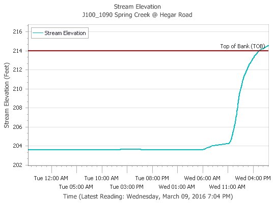
Spring Creek Near Hegar Road affecting the following counties in Texas...
Harris
For Spring Creek at Hegar Road, Minor flooding is forecasted.
Rainfall today has caused the creek to rise out of banks. Field Store Road in
Waller County is blocked at the creek and impassable. Hegar Road south of the
creek is starting to flood. Light to occasional moderate rain will persist
for the next several hours.
PRECAUTIONARY/PREPAREDNESS ACTIONS...
Persons with interests along these streams should keep alert to rising water and
take all precautions to protect their property. Do not drive or walk into
flooded areas the depth and water velocity could be too great for you to cross
safely. Motorists should avoid any water covered roads and find an alternate
route. Livestock and equipment should be removed from the flood plain
immediately.
NATIONAL WEATHER SERVICE HOUSTON/GALVESTON, TX
749 PM CST WED MAR 9 2016
...The National Weather Service in Houston/Galveston has issued a flood warning
for the following rivers...
Spring Creek Near Hegar Road affecting the following counties in Texas...
Harris
For Spring Creek at Hegar Road, Minor flooding is forecasted.
Rainfall today has caused the creek to rise out of banks. Field Store Road in
Waller County is blocked at the creek and impassable. Hegar Road south of the
creek is starting to flood. Light to occasional moderate rain will persist
for the next several hours.
PRECAUTIONARY/PREPAREDNESS ACTIONS...
Persons with interests along these streams should keep alert to rising water and
take all precautions to protect their property. Do not drive or walk into
flooded areas the depth and water velocity could be too great for you to cross
safely. Motorists should avoid any water covered roads and find an alternate
route. Livestock and equipment should be removed from the flood plain
immediately.
~~~When Thunder Roars Go Indoors~~~
~~~Turn Around Don't Drown~~~
~~~Run From The Water, Hide From The Wind~~~
~~~Turn Around Don't Drown~~~
~~~Run From The Water, Hide From The Wind~~~
thanks dj, maybe I'll sleep ok tonight.
That's a fear of mine too Kayci. And it was a reality for my family on Halloween. Jolted out of bed at 4:15 am to a roaring sound. Neither mine or my husband's weather alerts went off. It was right on top of us. Barely had enough time to grab the baby and pets to huddle in the bathroom closet. Luckily, our home was not damaged, but it did go through our back field. It was so loud and scary. Seemed like hours, but it was over in minutes. Hoping for just good rain tonight.kayci wrote:Quick question to my awesome Met friends.... does it look like a tornadic night? That scares me the most while sleeping.... Please say no.

It is coming down in Pearland.


Not a tornado event. More likely a heavy rain event with lightning and thunder.kayci wrote:Quick question to my awesome Met friends.... does it look like a tornadic night? That scares me the most while sleeping.... Please say no.
-
Texaspirate11

- Posts: 1278
- Joined: Tue Dec 31, 2013 12:24 am
- Contact:
Raining really nicely down by the bay. The lightning has stopped. But, the rain is great.
Just because you're disabled, you don't have to be a victim
Be Weather Aware & Prepared!
Barbara Jordan Winner in Media
Disability Integration Consultant
Be Weather Aware & Prepared!
Barbara Jordan Winner in Media
Disability Integration Consultant
We've had a good steady downpour in SGR now for about 30 minutes. Some Thunder and Lightning but nothing severe.
~~~When Thunder Roars Go Indoors~~~
~~~Turn Around Don't Drown~~~
~~~Run From The Water, Hide From The Wind~~~
~~~Turn Around Don't Drown~~~
~~~Run From The Water, Hide From The Wind~~~
FLOOD ADVISORY
NATIONAL WEATHER SERVICE HOUSTON/GALVESTON TX
1151 PM CST WED MAR 9 2016
TXC015-039-157-201-321-339-473-481-100745-
/O.NEW.KHGX.FA.Y.0010.160310T0551Z-160310T0745Z/
/00000.N.ER.000000T0000Z.000000T0000Z.000000T0000Z.OO/
WHARTON TX-WALLER TX-MONTGOMERY TX-MATAGORDA TX-BRAZORIA TX-
HARRIS TX-AUSTIN TX-FORT BEND TX-
1151 PM CST WED MAR 9 2016
THE NATIONAL WEATHER SERVICE IN LEAGUE CITY HAS ISSUED A
* FLOOD ADVISORY FOR...
EAST CENTRAL WHARTON COUNTY IN SOUTHEASTERN TEXAS...
SOUTHEASTERN WALLER COUNTY IN SOUTHEASTERN TEXAS...
SOUTHWESTERN MONTGOMERY COUNTY IN SOUTHEASTERN TEXAS...
NORTHEASTERN MATAGORDA COUNTY IN SOUTHEASTERN TEXAS...
WESTERN BRAZORIA COUNTY IN SOUTHEASTERN TEXAS...
WESTERN HARRIS COUNTY IN SOUTHEASTERN TEXAS...
SOUTHEASTERN AUSTIN COUNTY IN SOUTHEASTERN TEXAS...
FORT BEND COUNTY IN SOUTHEASTERN TEXAS...
* UNTIL 145 AM CST
* AT 1150 PM CST...DOPPLER RADAR INDICATED CLUSTERS OF STRONG STORMS
PRODUCING RAINFALL RATES UP TO 2 INCHES PER HOUR AT TIMES. ONE INCH OF
RAIN HAS ALREADY FALLEN ACROSS PARTS OF THE AREA AND ADDITIONS HEAVY
DOWNPOURS WILL CAUSE MINOR FLOODING IN THE ADVISORY AREA.
* SOME LOCATIONS THAT WILL EXPERIENCE FLOODING INCLUDE...
SUGAR LAND...MISSOURI CITY...ROSENBERG...NORTHWESTERN ANGLETON...
STAFFORD...EASTERN BAY CITY...BELLAIRE...KATY...RICHMOND...TOMBALL...
JERSEY VILLAGE...BROOKSHIRE...HUNTERS CREEK VILLAGE...WEST COLUMBIA...
SWEENY...BUNKER HILL VILLAGE...PINEY POINT VILLAGE...SPRING VALLEY...
FRESNO AND TOWN WEST.
~~~When Thunder Roars Go Indoors~~~
~~~Turn Around Don't Drown~~~
~~~Run From The Water, Hide From The Wind~~~
~~~Turn Around Don't Drown~~~
~~~Run From The Water, Hide From The Wind~~~
Can't imagine anyone being out on the water right now but I'm sure there are a few. If you are along the coast pay attention as well. HGX issues Special Marine Warning
BULLETIN - IMMEDIATE BROADCAST REQUESTED
SPECIAL MARINE WARNING
NATIONAL WEATHER SERVICE HOUSTON/GALVESTON TX
1154 PM CST WED MAR 9 2016
THE NATIONAL WEATHER SERVICE IN LEAGUE CITY HAS ISSUED A
* SPECIAL MARINE WARNING FOR...
COASTAL WATERS FROM FREEPORT TO MATAGORDA SHIP CHANNEL TX OUT 20
NM...
MATAGORDA BAY...
WATERS FROM FREEPORT TO MATAGORDA SHIP CHANNEL TX FROM 20 TO 60
NM...
* UNTIL 130 AM CST
* AT 1153 PM CST...A CLUSTER OF STRONG THUNDERSTORMS WAS LOCATED FROM NEAR
CARANCAHUA BAY TO 7 NM NORTH OF MATAGORDA ISLAND 557 TO NEAR BRAZOS
A70...MOVING NORTHEAST AT 20 KNOTS.
HAZARD...WIND GUSTS TO 40 KNOTS.
SOURCE...RADAR INDICATED.
IMPACT...SMALL CRAFT COULD BE DAMAGED IN BRIEFLY HIGHER WINDS AND
SUDDENLY HIGHER WAVES.
* LOCATIONS IMPACTED INCLUDE...
MATAGORDA JETTY...BRAZOS 490...BRAZOS B133...KELLER BAY...EAST
MATAGORDA BAY...BRAZOS 548...MATAGORDA ISLAND 607...PALACIOS BAY...
MATAGORDA BAY...BRAZOS A70...MATAGORDA SHIP CHANNEL...BRAZOS 439...TABS
BUOY W...TURTLE BAY...MATAGORDA ISLAND 557...CARANCAHUA BAY AND COX
BAY.
~~~When Thunder Roars Go Indoors~~~
~~~Turn Around Don't Drown~~~
~~~Run From The Water, Hide From The Wind~~~
~~~Turn Around Don't Drown~~~
~~~Run From The Water, Hide From The Wind~~~
FLOOD WARNING
NATIONAL WEATHER SERVICE HOUSTON/GALVESTON, TX
1158 PM CST WED MAR 9 2016
...The National Weather Service in Houston/Galveston has issued a flood warning
for the following rivers...
Menard Creek Near Rye affecting the following counties in Texas...Brazos...
Burleson...Grimes...Harris...Lee...Liberty...Madison...Montgomery...Polk...
Waller
Caney Creek Near Splendora affecting the following counties in Texas...
Brazos...Burleson...Grimes...Harris...Lee...Liberty...Madison...Montgomery...
Polk...Waller
Peach Creek Near Splendora affecting the following counties in Texas...
Brazos...Burleson...Grimes...Harris...Lee...Liberty...Madison...Montgomery...
Polk...Waller
Cypress Creek Near Katy-Hockley Road affecting the following counties in
Texas...Brazos...Burleson...Grimes...Harris...Lee...Liberty...Madison...
Montgomery...Polk...Waller
Cypress Creek Near Westfield affecting the following counties in Texas...
Brazos...Burleson...Grimes...Harris...Lee...Liberty...Madison...Montgomery...
Polk...Waller
Navasota River Near Normangee affecting the following counties in Texas...
Brazos...Burleson...Grimes...Harris...Lee...Liberty...Madison...Montgomery...
Polk...Waller
Middle Yegua Creek NEAR Dime Box affecting the following counties in Texas...
Brazos...Burleson...Grimes...Harris...Lee...Liberty...Madison...Montgomery...
Polk...Waller
For Navasota River at Normangee, Major flooding is forecasted. For Menard Creek
at Rye, Minor flooding is forecasted. For Caney Creek at Splendora, Minor
flooding is forecasted. For Peach Creek at Splendora, Minor flooding is
forecasted. For Cypress Creek at Katy-Hockley Road...Westfield, Minor flooding
is forecasted. For Middle Yegua Creek at Dime Box, Minor flooding is
forecasted.
The current weather is dominated by a persistent upper level storm system to the
west. This weather system will produce additional rainfall amounts ranging from 1
to 3 inches across parts of southeast Texas.
PRECAUTIONARY/PREPAREDNESS ACTIONS...
Persons with interests along these streams should keep alert to rising water and
take all precautions to protect their property. Do not drive or walk into
flooded areas the depth and water velocity could be too great for you to cross
safely. Motorists should avoid any water covered roads and find an alternate
route. Livestock and equipment should be removed from the flood plain
immediately.
~~~When Thunder Roars Go Indoors~~~
~~~Turn Around Don't Drown~~~
~~~Run From The Water, Hide From The Wind~~~
~~~Turn Around Don't Drown~~~
~~~Run From The Water, Hide From The Wind~~~
-
houstonia
- Posts: 138
- Joined: Sun Jun 14, 2015 6:51 pm
- Location: Houston, Texas (Southwest side; Sharpstown)
- Contact:
Okay, when these storms first started moving in, they came in a band from the southwest toward the ene, correct? Then it looked like they were moving off the gulf, north to south. Now when I look at the Hou/Gal radar, the storm cells look to be moving to the northwest.
Is this due to the movement of the low? Am I just imagining things?
Is this due to the movement of the low? Am I just imagining things?

Rainfall totals are really starting to pile-up now. Storm totals are approaching 7" across a wide swath of western Montgomery County now - with a lot more to come overnight. It looks like what was originally forecast last night is happening tonight.
No you aren't imagining things .... The Low is on the move albeit slowly!!! Some storms are tending to move a bit more NW but not by much.houstonia wrote:Okay, when these storms first started moving in, they came in a band from the southwest toward the ene, correct? Then it looked like they were moving off the gulf, north to south. Now when I look at the Hou/Gal radar, the storm cells look to be moving to the northwest.
Is this due to the movement of the low? Am I just imagining things?
~~~When Thunder Roars Go Indoors~~~
~~~Turn Around Don't Drown~~~
~~~Run From The Water, Hide From The Wind~~~
~~~Turn Around Don't Drown~~~
~~~Run From The Water, Hide From The Wind~~~