

Pretty sure the whole city of Austin has been awakened. These storms are loud.....
SPECIAL WEATHER STATEMENT
NATIONAL WEATHER SERVICE AUSTIN/SAN ANTONIO TX
1233 AM CST WED MAR 9 2016
TXZ173-192-090715-
WILLIAMSON TX-TRAVIS TX-
1233 AM CST WED MAR 9 2016
...SIGNIFICANT WEATHER ADVISORY FOR CENTRAL TRAVIS AND SOUTHWESTERN
WILLIAMSON COUNTIES UNTIL 115 AM CST...
AT 1233 AM CST...DOPPLER RADAR WAS TRACKING A STRONG THUNDERSTORM
NEAR ANDERSON MILL...MOVING NORTH AT 35 MPH.
DIME SIZE HAIL AND WINDS IN EXCESS OF 40 MPH WILL BE POSSIBLE WITH
THIS STORM.
LOCATIONS IMPACTED INCLUDE...
AUSTIN...ROUND ROCK...CEDAR PARK...GEORGETOWN...PFLUGERVILLE...TAYLOR...
WINDEMERE...AUSTIN BERGSTROM INT AP...ANDERSON MILL...LEANDER...HUTTO...
LAKEWAY...LAGO VISTA...MANOR...BEE CAVE...WEST LAKE HILLS...THE HILLS...
ROLLINGWOOD...LIBERTY HILL AND BARTON CREEK.
PRECAUTIONARY/PREPAREDNESS ACTIONS...
TORRENTIAL RAINFALL IS ALSO OCCURRING WITH THIS STORM...AND MAY LEAD
TO FLASH FLOODING. DO NOT DRIVE YOUR VEHICLE THROUGH FLOODED
ROADWAYS.
FREQUENT CLOUD TO GROUND LIGHTNING IS OCCURRING WITH THIS STORM.
LIGHTNING CAN STRIKE 10 MILES AWAY FROM A THUNDERSTORM. SEEK A SAFE
SHELTER INSIDE A BUILDING OR VEHICLE.
THIS STORM MAY INTENSIFY...SO BE CERTAIN TO MONITOR LOCAL RADIO AND
TV STATIONS...AS WELL AS LOCAL CABLE TV OUTLETS...FOR ADDITIONAL
INFORMATION AND POSSIBLE WARNINGS FROM THE NATIONAL WEATHER SERVICE.
March 2016 - Progressive Changeable Weather To End The Month
~~~When Thunder Roars Go Indoors~~~
~~~Turn Around Don't Drown~~~
~~~Run From The Water, Hide From The Wind~~~
~~~Turn Around Don't Drown~~~
~~~Run From The Water, Hide From The Wind~~~
..... And rain producers too...... For our friends out west...
FLOOD ADVISORY
NATIONAL WEATHER SERVICE AUSTIN/SAN ANTONIO TX
1236 AM CST WED MAR 9 2016
TXC013-021-029-031-053-055-091-187-209-259-287-299-453-491-493-
091100-
/O.NEW.KEWX.FA.Y.0005.160309T0636Z-160309T1100Z/
/00000.N.ER.000000T0000Z.000000T0000Z.000000T0000Z.OO/
BEXAR TX-BURNET TX-BASTROP TX-CALDWELL TX-TRAVIS TX-WILLIAMSON TX-
BLANCO TX-WILSON TX-ATASCOSA TX-COMAL TX-GUADALUPE TX-KENDALL TX-
LEE TX-HAYS TX-LLANO TX-
1236 AM CST WED MAR 9 2016
THE NATIONAL WEATHER SERVICE IN AUSTIN SAN ANTONIO HAS ISSUED A
* URBAN AND SMALL STREAM FLOOD ADVISORY FOR...
BEXAR COUNTY IN SOUTH CENTRAL TEXAS...
BURNET COUNTY IN SOUTH CENTRAL TEXAS...
CENTRAL BASTROP COUNTY IN SOUTH CENTRAL TEXAS...
WESTERN CALDWELL COUNTY IN SOUTH CENTRAL TEXAS...
TRAVIS COUNTY IN SOUTH CENTRAL TEXAS...
WILLIAMSON COUNTY IN SOUTH CENTRAL TEXAS...
BLANCO COUNTY IN SOUTH CENTRAL TEXAS...
NORTH CENTRAL WILSON COUNTY IN SOUTH CENTRAL TEXAS...
NORTH CENTRAL ATASCOSA COUNTY IN SOUTH CENTRAL TEXAS...
COMAL COUNTY IN SOUTH CENTRAL TEXAS...
GUADALUPE COUNTY IN SOUTH CENTRAL TEXAS...
EASTERN KENDALL COUNTY IN SOUTH CENTRAL TEXAS...
NORTHWESTERN LEE COUNTY IN SOUTH CENTRAL TEXAS...
HAYS COUNTY IN SOUTH CENTRAL TEXAS...
SOUTHEASTERN LLANO COUNTY IN SOUTH CENTRAL TEXAS...
* UNTIL 500 AM CST
* AT 1233 AM CST...DOPPLER RADAR INDICATED HEAVY RAIN DUE TO
THUNDERSTORMS. THIS WILL CAUSE URBAN AND SMALL STREAM FLOODING IN
THE ADVISORY AREA. UP TO ONE INCH OF RAIN HAS ALREADY FALLEN.
* SOME LOCATIONS THAT WILL EXPERIENCE FLOODING INCLUDE...
SAN ANTONIO...AUSTIN...ROUND ROCK...NEW BRAUNFELS...CEDAR PARK...
GEORGETOWN...PFLUGERVILLE...SAN MARCOS...SEQUIN...UNIVERSAL CITY...
TAYLOR...LOCKHART...BOERNE...ELGIN...BASTROP...MARBLE FALLS...BURNET...
WIMBERLEY...DRIPPING SPRINGS AND BLANCO.
ADDITIONAL RAINFALL AMOUNTS OF 1 TO 3 INCHES ARE EXPECTED OVER
THE I-35 CORRIDOR THROUGH 4 AM CST. THIS ADDITIONAL RAIN WILL MAKE
MINOR FLOODING AND HAZARDOUS PONDING IN URBANIZED AREAS.
PRECAUTIONARY/PREPAREDNESS ACTIONS...
BE ESPECIALLY CAUTIOUS AT NIGHT WHEN IT IS HARDER TO RECOGNIZE THE
DANGERS OF FLOODING. IF FLOODING IS OBSERVED ACT QUICKLY. DO NOT
DRIVE THROUGH AREAS WHERE WATER COVERS THE ROAD.
&&
~~~When Thunder Roars Go Indoors~~~
~~~Turn Around Don't Drown~~~
~~~Run From The Water, Hide From The Wind~~~
~~~Turn Around Don't Drown~~~
~~~Run From The Water, Hide From The Wind~~~
radar down all over ???

working elsewhere, must be a website issue?
http://preview.weather.gov/edd
http://wdssii.nssl.noaa.gov/web/wdss2/p ... 2vcp.shtml
http://weather.cod.edu/satrad/
working elsewhere, must be a website issue?
http://preview.weather.gov/edd
http://wdssii.nssl.noaa.gov/web/wdss2/p ... 2vcp.shtml
http://weather.cod.edu/satrad/
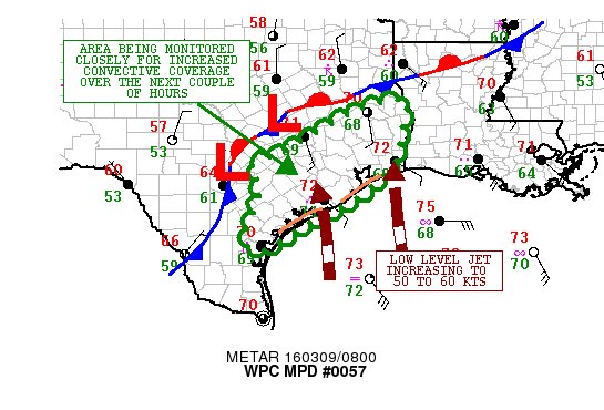
MESOSCALE PRECIPITATION DISCUSSION 0057
NWS WEATHER PREDICTION CENTER COLLEGE PARK MD
314 AM EST WED MAR 09 2016
AREAS AFFECTED...SOUTHEAST TX
CONCERNING...HEAVY RAINFALL...FLASH FLOODING POSSIBLE
VALID 090800Z - 091030Z
SUMMARY...INCREASING CONVECTION IS LIKELY OVER THE NEXT COUPLE OF
HOURS. ISOLATED RUNOFF PROBLEMS/FLASH FLOODING CONCERNS ARE
POSSIBLE THROUGH 10Z...WITH MUCH STRONGER SIGNALS FOR EXCESSIVE
RAIN THEREAFTER.
DISCUSSION...IR SATELLITE IMAGERY SHOWS COOLING CONVECTIVE TOPS
DOWN ALONG THE MIDDLE TX COAST...AND THE TENDENCY OVER THE LAST
HOUR OR SO HAS BEEN FOR A GRADUAL INCREASE IN COVERAGE. MUCH
STRONGER CONVECTION AND HEAVIER RAINS ARE OCCURRING FARTHER NORTH
AND WEST ALONG A FRONTAL ZONE AHEAD OF A WEAK ARE OF LOW
PRESSURE...BUT THERE ARE INDICATIONS THAT CONVECTION WILL
GRADUALLY BECOME MORE FOCUSED ALONG THE CENTRAL AND UPPER TX COAST
APPROACHING 12Z AND BEYOND.
HIRES MODELS INCLUDING MULTIPLE RUNS OF THE HRRR SUGGEST AN
INCREASINGLY FAVORABLE ENVIRONMENT FOR EXPANDING CONVECTION WITH
VERY INTENSE RAINFALL RATES ACROSS THE IMMEDIATE SOUTHEAST TX
COASTAL PLAIN. ALREADY AREA VWP DATA FROM KHGX INDICATES A LOW
LEVEL JET NOW OF 40 TO 45 KTS...WHICH IS FORECAST TO INCREASE TO
50 TO 60 KTS BY 12Z. THIS WILL BE TRANSPORTING A DEEP LAYER OF
SUBTROPICAL MOISTURE NORTHWARD INTO NORTHWESTERN GULF COAST...WITH
PWATS EXPECTED TO REACH AS HIGH AS 1.75 INCHES OVER THE NEXT FEW
HOURS. IN FACT...THE CIRA LAYERED PWAT PRODUCT SHOWS A DUAL
CONFLUENCE ZONE OF MOISTURE INTO SOUTHEAST TX AND SOUTHWEST
LA...WITH A LONG-TRACK FEED FROM THE EASTERN TROPICAL PACIFIC
OCEAN AND ALSO IN FROM THE SOUTHERN GULF OF MEXICO.
THE STRONGER MOISTURE TRANSPORT AND MODEST INSTABILITY INTO THE
REGION COUPLED WITH APPROACHING SHORTWAVE DYNAMICS AND EXCELLENT
UPPER JET SUPPORT SHOULD ALLOW THE CONVECTION TO EXPAND IN
COVERAGE AND INTENSITY.
RAINFALL RATES OF UP TO 2 INCHES/HR OR GREATER ARE EXPECTED WITH
THE MORE INTENSE CORES OVER THE NEXT COUPLE OF HOURS. ANOTHER MPD
WILL BE NEEDED AFTER 10Z ACROSS THIS REGION WHICH WILL ADDRESS THE
EXPECTED LARGER SCALE HEAVY RAINS EXPECTED THIS MORNING OVER
SOUTHEAST TX.
ORRISON
ATTN...WFO...CRP...EWX...HGX...LCH...SHV...
~~~When Thunder Roars Go Indoors~~~
~~~Turn Around Don't Drown~~~
~~~Run From The Water, Hide From The Wind~~~
~~~Turn Around Don't Drown~~~
~~~Run From The Water, Hide From The Wind~~~
"CIRA LAYERED PWAT" http://cat.cira.colostate.edu/sport/lay ... ed/lpw.htm
animated gif (very large) http://cat.cira.colostate.edu/sport/lay ... ed_LPW.gif
animated gif (very large) http://cat.cira.colostate.edu/sport/lay ... ed_LPW.gif

There are isolated intense areas of rain, but there are indeed bust-like elements. A central core of rain has not filled it.
However, the I-35 corridor may see some entraining. Calling it a night...
However, the I-35 corridor may see some entraining. Calling it a night...
bust!
-
srainhoutx

- Site Admin

- Posts: 19616
- Joined: Tue Feb 02, 2010 2:32 pm
- Location: Maggie Valley, NC
- Contact:
Heavy rain and thunder here in NW Harris County.
Carla/Alicia/Jerry(In The Eye)/Michelle/Charley/Ivan/Dennis/Katrina/Rita/Wilma/Humberto/Ike/Harvey
Member: National Weather Association
Facebook.com/Weather Infinity
Twitter @WeatherInfinity
Member: National Weather Association
Facebook.com/Weather Infinity
Twitter @WeatherInfinity
-
srainhoutx
- Site Admin
- Posts: 19616
- Joined: Tue Feb 02, 2010 2:32 pm
- Location: Maggie Valley, NC
- Contact:
Update from Jeff:
Satellite and radar trends show steady increase in stronger thunderstorms with heavy rainfall around Matagorda Bay with several short term models showing increasing coverage of thunderstorms and heavy rainfall through 600am over much of SE TX. Signal for cell training increases even more after sunrise and focuses either side of US 59. This increase in activity is the result of increasing lift associated with the very slow eastward progression of the main upper level system over west-central MX. Moisture levels are very high and will continue to support hourly rainfall rates of 1-3 inches per hour under the heaviest storms.
Note: NWS link to radar is not updating on time for some unknown reason. The following link can be used to get the latest updated radar data.
http://www.srh.noaa.gov/ridge2/
Carla/Alicia/Jerry(In The Eye)/Michelle/Charley/Ivan/Dennis/Katrina/Rita/Wilma/Humberto/Ike/Harvey
Member: National Weather Association
Facebook.com/Weather Infinity
Twitter @WeatherInfinity
Member: National Weather Association
Facebook.com/Weather Infinity
Twitter @WeatherInfinity
-
srainhoutx
- Site Admin
- Posts: 19616
- Joined: Tue Feb 02, 2010 2:32 pm
- Location: Maggie Valley, NC
- Contact:
The Weather Prediction Center continues with a Moderate Risk for Excessive Rainfall. Increases to High Risk for East Texas/Western Louisiana.
- Attachments
-
Carla/Alicia/Jerry(In The Eye)/Michelle/Charley/Ivan/Dennis/Katrina/Rita/Wilma/Humberto/Ike/Harvey
Member: National Weather Association
Facebook.com/Weather Infinity
Twitter @WeatherInfinity
Member: National Weather Association
Facebook.com/Weather Infinity
Twitter @WeatherInfinity

Whoa? Wait? What? ....just woke up for work and nothing falling and nothing but light mist overnight. Did the models miss the bullseye areas by well, A LOT? Or is this thing a lot slower than originally thought and it hasn't shifted eastward yet? Looks like the main rain shield that was meant for SETX stayed west and now north. Is there another round after this one that will be further east? I was ready for a treacherous drive to work.
Mike
Beaumont, TX
(IH-10 & College Street)
Beaumont, TX
(IH-10 & College Street)

-
Katdaddy

- Global Moderator

- Posts: 2503
- Joined: Thu Feb 04, 2010 8:18 am
- Location: League City, Tx
- Contact:
Heavy rain and thunderstorms have occurred across portions of SE TX overnight and the early morning hours. The slow moving upper level low will extend the heavy rainfall threat through Thursday morning with unsettled weather possible through Saturday. The potential remains for 3-7" rains over the next 12-24 hours but thankfully the severe weather did not materialize over S Central and SE TX yesterday afternoon or during the early morning hours. From this morning's Houston-Galveston The Flash Flood Watch to continue until 6 PM. In addition some strong to severe thunderstorms will be possible today. From this morning's Houston-Galveston AFD:
ONGOING HEAVY RAINFALL THREAT WILL CONTINUE TODAY AS A FAVORABLE REGION FOR THUNDERSTORM DEVELOPMENT PERSISTS OVER SE TEXAS.
Remain weather aware and do not drive through high water if encountered later today.
ONGOING HEAVY RAINFALL THREAT WILL CONTINUE TODAY AS A FAVORABLE REGION FOR THUNDERSTORM DEVELOPMENT PERSISTS OVER SE TEXAS.
Remain weather aware and do not drive through high water if encountered later today.
- Attachments
-
- Screen Shot 2016-03-09 at 5.16.32 AM.png (101.21 KiB) Viewed 4592 times
https://twitter.com/NWSHouston/status/7 ... 5654972416
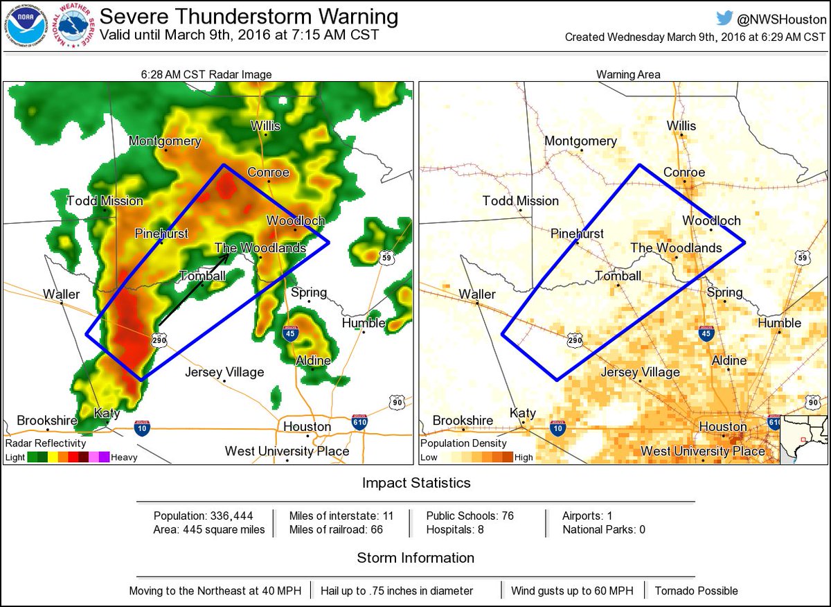
@NWSHouston
Severe Thunderstorm Warning for NW Harris and SE Montgomery Co until 715AM. Damaging winds possible. #houwx #txwx

@NWSHouston
Severe Thunderstorm Warning for NW Harris and SE Montgomery Co until 715AM. Damaging winds possible. #houwx #txwx
Last edited by unome on Wed Mar 09, 2016 6:41 am, edited 1 time in total.
all TX weather alerts http://alerts.weather.gov/cap/tx.php?x=1
Busted and not even close
I agree. The HRRR Model was off on this one. Everything is north and east of us here in Houston area. And all the rain has moved out of the area for this morning.Cromagnum wrote:Busted and not even close
Don't forget folks - daylight savings time changes this weekend! Spring forward an hour!
-
TeamPlayersBlue
- Posts: 36
- Joined: Thu Feb 03, 2011 8:50 pm
- Contact:
To be fair, the HRRR was never really consistent yesterday. It couldnt get a solid grasp on the dynamics of the storm. Possibly this has something to do with the lack of air samples from Mexico.Either way, it was all over the place yesterday afternoon with every single run. I will say this though, we have alot of football left with this system as long as there is moisture being pumped up and there are boundaries over the SE Tx region. Could create a dangerous situation very quickly.
-
nuby3
- Posts: 387
- Joined: Mon Feb 22, 2010 10:25 pm
- Location: THE WOODLANDS PARKWAY and FM 2978
- Contact:
timing is off but I don't think this is over yet
http://radar.weather.gov/radar.php?rid= ... 1&loop=yes
http://radar.weather.gov/radar.php?rid= ... 1&loop=yes
-
- Information
-
Who is online
Users browsing this forum: Ahrefs [Bot], Bing [Bot], mcheer23 and 51 guests