March 2016 - Progressive Changeable Weather To End The Month

General Weather Discussions and Analysis
User avatar
Ptarmigan
Statistical Specialist
Posts: 4011
Joined: Wed Feb 03, 2010 7:20 pm
Contact:

wxman57 wrote:10 inches or more in parts of Harris County is possible. I'm thinking widespread amounts in the 4-6 inch range Tue-Thu. Peak rainfall in the county could top 10". Wednesday is not going to be a pleasant weather day. Careful on the roadways, there will be flooding.
Flooding in March has happened.

Years With Flooding In March
1944
1957
1964
1972
1992
1993
1997
1999
2001

http://www.wxresearch.com/almanac/houflood.html
User avatar
Katdaddy
Global Moderator
Global Moderator
Posts: 2502
Joined: Thu Feb 04, 2010 8:18 am
Location: League City, Tx
Contact:

Remain weather aware today, tonight, and through Wednesday afternoon as significant flood and severe weather event develops across S and SE TX. Severe storms ongoing across W Central TX and beginning to develop along the Coastal Bend and Hill Country. A busy 24-36 hours ahead From this morning's Houston-Galveston AFD:

A POTENT UPPER LEVEL STORM SYSTEM WILL BRING THE POTENTIAL FOR A DANGEROUS FLOOD EVENT ACROSS SE TEXAS TONIGHT AND WEDNESDAY.

Severe weather is a concern from late this morning through the overnight hours with a very strong 45-60kt low level jet and helicity values near 600. Tornadoes and damaging winds will be possible. The SPC has an enhanced area for S, S Central, and SE TX.

In addition Coastal Flood Warnings have been issued for the Upper TX Coast due to strong S winds of 25-30kts with gusts of 40-45kt bringing tides of 3-4ft above MSL. Gale Warnings have also been issued for the coastal waters for this evening and tonight

Flash Flood Watch remains in effect with the 4-8" rains likely and even higher amounts up 12" through Wednesday afternoon. The Wednesday morning commute could be dangerous so remember the phrase "turn around don't drown" should you encounter high water.
Attachments
Screen Shot 2016-03-08 at 5.20.05 AM.png
Screen Shot 2016-03-08 at 5.20.05 AM.png (30.67 KiB) Viewed 3533 times
Screen Shot 2016-03-08 at 5.18.21 AM.png
Screen Shot 2016-03-08 at 5.18.21 AM.png (14.75 KiB) Viewed 3533 times
Screen Shot 2016-03-08 at 5.18.58 AM.png
Screen Shot 2016-03-08 at 5.18.58 AM.png (13.02 KiB) Viewed 3533 times
unome
Posts: 3059
Joined: Fri Feb 12, 2010 6:11 pm

new mesoscale discussion http://www.spc.noaa.gov/products/md/md0184.html

Image


MESOSCALE DISCUSSION 0184
NWS STORM PREDICTION CENTER NORMAN OK
0706 AM CST TUE MAR 08 2016

AREAS AFFECTED...MUCH OF E CNTRL TX

CONCERNING...SEVERE POTENTIAL...WATCH LIKELY

VALID 081306Z - 081530Z

PROBABILITY OF WATCH ISSUANCE...80 PERCENT

SUMMARY...SCATTERED STORMS ARE EXPECTED TO AFFECT MUCH OF E CNTRL TX
THROUGHOUT MUCH OF THE DAY. DAMAGING WINDS, HAIL AND A BRIEF TORNADO
OR TWO WILL ALL BE POSSIBLE.

DISCUSSION...A LINE OF STORMS...CONTAINING PERIODIC EMBEDDED
CIRCULATIONS AS WELL AS HAIL CORES...CONTINUES TO MOVE EWD ACROSS N
CNTRL INTO CNTRL TX. ALTHOUGH THIS SYSTEM IS LARGELY LINEAR...AREAS
OF ROTATION HAVE BEEN NOTED AT TIMES. ALSO...NEW CELLS ARE
CURRENTLY DEVELOPING AWAY FROM THE LINE ACROSS CNTRL TX. RADAR ALSO
SHOWS SHALLOW SHOWERS OVER MUCH OF THE WARM SECTOR E OF THE
STORMS...SUGGESTING OTHER PRE-LINE DEVELOPMENT IS POSSIBLE.

ALTHOUGH WIND AND HAIL IS THE MAIN THREAT CURRENTLY...THE TORNADO
THREAT MAY INCREASE AS STORMS EVOLVE FARTHER EWD WHERE LOW-LEVEL
SHEAR IS STRONGER AND AS MOISTURE CONTINUES TO INCREASE BENEATH
RELATIVELY STEEP MIDLEVEL LAPSE RATES.

..JEWELL/CORFIDI.. 03/08/2016


ATTN...WFO...SHV...HGX...FWD...CRP...EWX...SJT...

LAT...LON 33409681 33199628 32719559 32179537 31109498 29539455
29009515 28449640 28899730 29689873 30959891 31839849
33179806 33409754 33409681
unome
Posts: 3059
Joined: Fri Feb 12, 2010 6:11 pm

new tornado watch http://www.spc.noaa.gov/products/watch/ww0037.html

Image

SEL7

URGENT - IMMEDIATE BROADCAST REQUESTED
TORNADO WATCH NUMBER 37
NWS STORM PREDICTION CENTER NORMAN OK
725 AM CST TUE MAR 8 2016

THE NWS STORM PREDICTION CENTER HAS ISSUED A

* TORNADO WATCH FOR PORTIONS OF
CENTRAL TEXAS

* EFFECTIVE THIS TUESDAY MORNING AND AFTERNOON FROM 725 AM UNTIL
100 PM CST.

* PRIMARY THREATS INCLUDE...
A COUPLE TORNADOES POSSIBLE
SCATTERED DAMAGING WIND GUSTS TO 70 MPH POSSIBLE
ISOLATED VERY LARGE HAIL EVENTS TO 2 INCHES IN DIAMETER POSSIBLE

SUMMARY...A BROKEN BAND OF THUNDERSTORMS...INCLUDING A FEW
SUPERCELLS CAPABLE OF SEVERE HAIL...DAMAGING WIND...AND
TORNADOES...WILL MOVE GENERALLY EAST-NORTHEAST ACROSS WATCH AREA
THROUGH EARLY AFTERNOON. OTHER STORMS MAY FORM AHEAD OF THE LINE
ACROSS EAST CENTRAL TEXAS.

THE TORNADO WATCH AREA IS APPROXIMATELY ALONG AND 100 STATUTE
MILES EAST AND WEST OF A LINE FROM 25 MILES EAST OF DALLAS TEXAS
TO 25 MILES SOUTH OF AUSTIN TEXAS. FOR A COMPLETE DEPICTION OF
THE WATCH SEE THE ASSOCIATED WATCH OUTLINE UPDATE (WOUS64 KWNS
WOU7).

PRECAUTIONARY/PREPAREDNESS ACTIONS...

REMEMBER...A TORNADO WATCH MEANS CONDITIONS ARE FAVORABLE FOR
TORNADOES AND SEVERE THUNDERSTORMS IN AND CLOSE TO THE WATCH
AREA. PERSONS IN THESE AREAS SHOULD BE ON THE LOOKOUT FOR
THREATENING WEATHER CONDITIONS AND LISTEN FOR LATER STATEMENTS
AND POSSIBLE WARNINGS.

&&

OTHER WATCH INFORMATION...CONTINUE...WW 36...

AVIATION...TORNADOES AND A FEW SEVERE THUNDERSTORMS WITH HAIL
SURFACE AND ALOFT TO 2 INCHES. EXTREME TURBULENCE AND SURFACE
WIND GUSTS TO 60 KNOTS. A FEW CUMULONIMBI WITH MAXIMUM TOPS TO
500. MEAN STORM MOTION VECTOR 23030.


...CORFIDI
unome
Posts: 3059
Joined: Fri Feb 12, 2010 6:11 pm

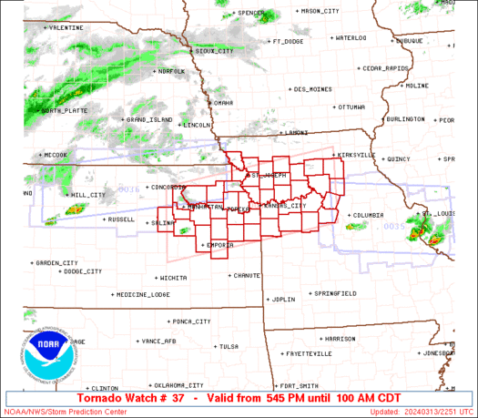
latest day 1 convective outlook - hatched for tornado
(Hatched Area: 10% or greater probability of EF2 - EF5 tornadoes within 25 miles of a point)

http://www.spc.noaa.gov/products/outlook/day1otlk.html

Image

SPC AC 081256

DAY 1 CONVECTIVE OUTLOOK
NWS STORM PREDICTION CENTER NORMAN OK
0656 AM CST TUE MAR 08 2016

VALID 081300Z - 091200Z

...THERE IS AN ENH RISK OF SVR TSTMS FROM S CNTRL TX ENE TO THE UPR
TX GULF CST...

...THERE IS A SLGT RISK OF SVR TSTMS FROM DEEP S TX N AND NNE INTO
CNTRL OK AND THE ARKLATEX...

...THERE IS A MRGL RISK OF SVR TSTMS OVER A LARGE PART OF THE S
CNTRL U.S....

...SUMMARY...
SEVERAL EPISODES OF SEVERE THUNDERSTORMS WILL OCCUR TODAY THROUGH
EARLY WEDNESDAY OVER MUCH OF THE SOUTHERN PLAINS. THE GREATEST RISK
FOR SEVERE WEATHER...INCLUDING A FEW TORNADOES IN ADDITION TO HAIL
AND DAMAGING WIND...WILL EXIST OVER SOUTH TEXAS AND THE TEXAS GULF
COASTAL PLAIN.

...SYNOPTIC SETUP...
VERY SLOWLY PROGRESSIVE SPLIT FLOW PATTERN WILL PREVAIL OVER THE LWR
48 THIS PERIOD...WITH NW MEXICO UPR LOW BECOMING FURTHER REMOVED
FROM THE MAIN BELT OF WLYS OVER THE NRN U.S./SRN CANADA. THE MEXICAN
LOW SHOULD CONTINUE SE ACROSS SONORA TODAY...BEFORE REDEVELOPING ESE
INTO CHIHUAHUA TNGT/EARLY WED. THIS PATTERN WILL MAINTAIN AND
SLIGHTLY BACK DEEP SSW FLOW ALREADY ESTABLISHED ACROSS THE SRN
PLNS/LWR MS VLY.

AT LWR LVLS...INCREASINGLY MOIST SSELY FLOW WILL PERSIST FROM CNTRL
AND ERN TX INTO THE ARKLATEX...E OF ILL-DEFINED S CNTRL TX SFC
LOW/INVERTED TROUGH. THE LOW SHOULD REDEVELOP SLOWLY E/SE TOWARD THE
S TX GULF CST BY 12Z WED.

...SRN PLNS TO SABINE RVR VLY TODAY THROUGH EARLY WED...
OVERNIGHT SVR STORMS IN W CNTRL AND S CNTRL TX HAVE EVOLVED INTO A
LOOSELY ORGANIZED LINEAR MCS NOW OVER CNTRL TX. THIS CONVECTIVE
SYSTEM SHOULD CONTINUE ENE INTO N CNTRL/NE TX BY MIDDAY. GIVEN 50+
KT SLY LLJ AND PW INCREASING TO AOA 1.50 INCHES...EXPECTED A
CONTINUED RISK FOR EMBEDDED STORMS WITH SVR HAIL/WIND AND POSSIBLY A
TORNADO...ESPECIALLY ON THE SRN END OF THE SYSTEM TOWARD WACO
AND...LATER...POSSIBLY COLLEGE STATION. THE STORMS SHOULD
WEAKEN...HOWEVER...UPON ENCOUNTERING SOMEWHAT DRIER LOW-LVL AIR A
BIT LATER IN THE DAY OVER THE ARKLATEX. OTHER STORMS NOW FORMING
ALONG SLIGHTLY ELEVATED WARM FRONT OVER NW TX AND SW OK MAY POSE A
MARGINAL SVR HAIL/WIND RISK AS THE ACTIVITY SPREADS NE INTO CNTRL
AND ERN OK LATER THIS MORNING.

SFC HEATING AND INCREASING HEIGHT FALLS ASSOCIATED WITH EXPECTED ESE
WOBBLE OF MEXICAN UPR LOW SHOULD PROMOTE DEVELOPMENT OF NEW TSTMS
OVER THE HIGHER TERRAIN OF NRN MEXICO LATE THIS AFTN. BY EARLY
EVE...THE SAME HEIGHT FALLS...COUPLED WITH LOW-LVL UPLIFT ALONG
COMPOSITE OUTFLOW BOUNDARY LEFT BY THE MRNG MCS...SHOULD ALSO FOSTER
STORM DEVELOPMENT OVER S CNTRL TX NWD ALONG THE I-35 CORRIDOR AND
ESCARPMENT.

WITH AMPLE /50+ KT/ SSWLY DEEP SHEAR AND BUOYANCY /MUCAPE AOA 2000 J
PER KG/ FOR SUPERCELLS...BOTH AREAS OF STORMS WILL BE CAPABLE OF
LARGE HAIL...DMGG WIND...AND POSSIBLY A COUPLE TORNADOES. THE
CONVECTION SHOULD EVOLVE INTO SEVERAL LARGE MCSS THAT MOVE/DEVELOP
GENERALLY NNE THROUGH THE NGT IN RESPONSE TO
BROADENING/STRENGTHENING SLY LLJ AHEAD OF APPROACHING UPR LOW. 50-70
KT DEEP/DIFFLUENT SSWLY MID/UPR-LVL FLOW ATOP RICHLY-MOIST /PW
AROUND 1.75 INCHES/ 30-40 KT SSELY NEAR-SFC WINDS WILL SUPPORT THE
MAINTENANCE OF EMBEDDED SUPERCELLS/LEWPS WITH A RISK FOR
TORNADOES...IN ADDITION TO LOCALLY DMGG WIND/SVR HAIL. THIS
POTENTIAL MAY MAXIMIZE OVER THE MIDDLE AND UPR TX GULF CSTL
PLN...INCLUDING THE CRP TO HOU CORRIDOR...LATE TNGT THROUGH 12Z WED.

..CORFIDI/DEAN.. 03/08/2016

CLICK TO GET WUUS01 PTSDY1 PRODUCT

NOTE: THE NEXT DAY 1 OUTLOOK IS SCHEDULED BY 1630Z
CURRENT UTC TIME: 1330Z (7:30AM), RELOAD THIS PAGE TO UPDATE THE TIME
unome
Posts: 3059
Joined: Fri Feb 12, 2010 6:11 pm

Image
Image

Tornado Warning http://alerts.weather.gov/cap/wwacapget ... 9be9178bd7

Message: NOAA-NWS-ALERTS-TX1255F00142C8.TornadoWarning.1255F0015DBCTX.FWDTORFWD.7c3b55bbd86e05f1590cd69be9178bd7 from w-nws.webmaster@noaa.gov
Sent: 07:46 CST on 03-08-2016
Effective: 07:46 CST on 03-08-2016
Expires: 08:15 CST on 03-08-2016
Event: Tornado Warning
Alert:

THE NATIONAL WEATHER SERVICE IN FORT WORTH HAS ISSUED A

* TORNADO WARNING FOR...
NORTHEASTERN HOOD COUNTY IN NORTH CENTRAL TEXAS...
SOUTHEASTERN PARKER COUNTY IN NORTH CENTRAL TEXAS...
NORTHWESTERN JOHNSON COUNTY IN NORTH CENTRAL TEXAS...
SOUTHWESTERN TARRANT COUNTY IN NORTH CENTRAL TEXAS...

* UNTIL 815 AM CST

* AT 745 AM CST...A SEVERE THUNDERSTORM CAPABLE OF PRODUCING A
TORNADO WAS LOCATED 8 MILES NORTHEAST OF GRANBURY...MOVING
NORTHEAST AT 40 MPH.

*A SECOND STORM WAS LOCATED ABOUT 10 MILES SOUTH OF
WEATHERFORD...ALSO MOVING NORTHEAST AT 40 MPH.
HAZARD...TORNADO.
SOURCE...RADAR INDICATED ROTATION.
IMPACT...FLYING DEBRIS WILL BE DANGEROUS TO THOSE CAUGHT WITHOUT
SHELTER. MOBILE HOMES WILL BE DAMAGED OR DESTROYED.
DAMAGE TO ROOFS...WINDOWS...AND VEHICLES WILL OCCUR. TREE
DAMAGE IS LIKELY.

* THIS DANGEROUS STORM WILL BE NEAR...
GODLEY AROUND 755 AM CST.
BENBROOK AND CROWLEY AROUND 815 AM CST.
OTHER LOCATIONS IMPACTED BY THIS TORNADIC THUNDERSTORM INCLUDE
ANNETTA NORTH AND ANNETTA SOUTH.
THIS INCLUDES THE FOLLOWING INTERSTATES...
INTERSTATE 20 BETWEEN MILE MARKERS 412 AND 428.
INTERSTATE 30 BETWEEN MILE MARKERS 1 AND 5.
INTERSTATE 820 BETWEEN MILE MARKERS 1 AND 3.
TORNADO...RADAR INDICATED
HAIL...<.75IN

Instructions: TAKE COVER NOW! MOVE TO A BASEMENT OR AN INTERIOR ROOM ON THE LOWEST FLOOR OF A STURDY BUILDING. AVOID WINDOWS. IF YOU ARE OUTDOORS...IN A MOBILE HOME...OR IN A VEHICLE...MOVE TO THE CLOSEST SUBSTANTIAL SHELTER AND PROTECT YOURSELF FROM FLYING DEBRIS.
Target Area:
Hood
Johnson
Parker
Tarrant
Forecast Office: NWS Dallas-Fort Worth (Dallas - Forth Worth)
User avatar
srainhoutx
Site Admin
Site Admin
Posts: 19616
Joined: Tue Feb 02, 2010 2:32 pm
Location: Maggie Valley, NC
Contact:

Morning briefing from Jeff:

***High impact…potentially dangerous…weather event this afternoon-Wednesday***

Tornado Watch issued for the NW 1/3rd of SE TX until 100pm

Flash Flood Watch all counties from noon today until 600pm Wednesday

Coastal Flood Warning Harris, Galveston, Brazoria, Chambers Counties from noon today to noon Wednesday.

Discussion:
Monster of an upper level storm system dropping SE into NW MX this morning and will continue to dig SE deeper into MX today and tonight. Low level jet is already howling across coastal TX with 925mb winds of 45kts transporting deep tropical moisture into the region. Short wave within the flow on the far eastern flank of this storm system is current approaching SE TX and meso scale models show scattered showers currently from Matagorda Bay to College Station erupting into thunderstorms this morning. Backed low level winds will support a tornado threat with these storms…enhance the issuance of the tornado watch for the College Station area.

Main event will be this evening into Wednesday as ingredients are coming together to produce a dangerous flash flood event across SE TX. Development of a nearly stalled low level boundary this evening, increase in the low level jet after dark, increasing large scale lift, and storms developing nearly parallel to the upper level flow (SSW to NNE) support a high flash flood threat. Moisture levels surge to near 1.9 inches (1.92 on the NAM forecast soundings) which is +2 SD above normal and at or above expected maximum levels for early March. This combined with the prolonged and sustained lift points toward a major rainfall event with flash flooding. I am very worried that storms will anchor at some point tonight in the low level flow and dump hour after hour on the region…but where this may happen is impossible to predict. Given everything in place would not be surprised to see a few 12 inch totals in the next 24 hours over SE TX.

Rainfall:

Widespread: 4-6
Isolated: 8-10

Flood Threat:
Rainfall of this magnitude will cause flooding especially in urban areas with the high hourly rainfall rates. Concern is certainly there for mainstem river flooding on the San Jacinto and Trinity basins given the very high totals and widespread nature of the event. Within Harris County rapid rises on area watershed seem likely and depending on where the greatest rain falls some watersheds may exceed their banks.

Severe:
Threat is already increasing over the NW part of the area and will continue to increase today into tonight. Low level shear values increase this evening as surface winds back more to the ESE and SE with oncoming height falls forcing surface low pressure over SW TX. This will increase the shear effect on updrafts. Really focusing in on the area around Matagorda Bay WSW toward the Rio Grande where the air mass will become most unstable this afternoon. Storms may initiate as supercells in this region with a higher tornado threat before transitions into a more damage wind threat over most of SE TX. Will not tone down the tornado potential over SE TX as any sustained cells with all the shear could rotate and produce a tornado this afternoon-Wednesday morning. This will be a prolonged severe threat for almost 24 hours for the region.

Tides:
Coastal water levels are running 1.0-1.5 ft above normal currently in Galveston Bay and NE of Freeport. Strong onshore flow will continue to push water toward the coast along with wave run-up and tidal trapping in the NW portion of Galveston Bay. Winds really ramp up this afternoon and evening which may require a short fused Gale Warning. This will likely push total water levels to near warning criteria on the Gulf beaches along Bolivar and the west end of Galveston Island where overwash is looking increasing likely. Could see some problems on the west side of Galveston Bay also, but wave run-up is not as great in this area compared to the Gulf beaches. Tides in Matagorda Bay will run 1-2 ft above normal.

Wednesday afternoon-Friday:
Will maintain additional period of thunderstorms as the main upper low rotates into and across the region. Hard to time rain and dry period at this point and main focus right now is getting through tonight and Wednesday morning.

Actions:
Residents across the region should be prepared for rapidly changing weather conditions over the next 24 hours. Plan for excessive rainfall and flooding along with severe weather potential. Know what you will do if faced with one of these threats or a warning is issued for your area. Do not drive into high water…the majority of all flash flood fatalities are from persons who drive into high water and are swept away.

Next 24-hr Excessive Rainfall Threat:
03082016 Jeff 1 unnamed.gif
72-hr Rainfall Forecast:
03082016 Jeff 2 unnamed.gif
SPC Severe Weather Outlook:
03082016 Jeff 3 unnamed.gif
Tornado Watch Box Outline and Radar Overlay:
03082016 Jeff 4 unnamed.gif
[/i]
Carla/Alicia/Jerry(In The Eye)/Michelle/Charley/Ivan/Dennis/Katrina/Rita/Wilma/Humberto/Ike/Harvey

Member: National Weather Association
Facebook.com/Weather Infinity
Twitter @WeatherInfinity
User avatar
srainhoutx
Site Admin
Site Admin
Posts: 19616
Joined: Tue Feb 02, 2010 2:32 pm
Location: Maggie Valley, NC
Contact:

12Z NAM sounding near the Waller/NW Harris County line early tomorrow morning:
Attachments
03082016 12Z nam_2016030812_021_29_99--96_08.png
Carla/Alicia/Jerry(In The Eye)/Michelle/Charley/Ivan/Dennis/Katrina/Rita/Wilma/Humberto/Ike/Harvey

Member: National Weather Association
Facebook.com/Weather Infinity
Twitter @WeatherInfinity
User avatar
srainhoutx
Site Admin
Site Admin
Posts: 19616
Joined: Tue Feb 02, 2010 2:32 pm
Location: Maggie Valley, NC
Contact:

Also the 12Z NAM suggests near 2+ Precipitable Water values which suggests +2, nearing +3 Standard Deviation above normal for March. Any supercells that may form are capable of dropping very heavy rainfall rates near or slight above 3 inches per hour.
Attachments
03082016 12Z NAM 24 pwatsc.png
Carla/Alicia/Jerry(In The Eye)/Michelle/Charley/Ivan/Dennis/Katrina/Rita/Wilma/Humberto/Ike/Harvey

Member: National Weather Association
Facebook.com/Weather Infinity
Twitter @WeatherInfinity
User avatar
srainhoutx
Site Admin
Site Admin
Posts: 19616
Joined: Tue Feb 02, 2010 2:32 pm
Location: Maggie Valley, NC
Contact:

Cold core upper low/trough continues to dig SE over the Baja Peninsula and if the guidance is correct, a closed core cold 500mb low will be positioned near or just West of Monterrey, Nuevo Leon tonight where heavy mountain snow is likely. Starting to see a lot of clearing across SW and West Texas along the dryline. This should lead to further destabilization this afternoon as additional thunderstorms develop near the Rio Grande River Valley around Lerado and on ENE and congeal into a MCS across S Central Texas moving East this evening into the overnight hours.
Attachments
03082016 1430Z TX VIS latest.jpg
Carla/Alicia/Jerry(In The Eye)/Michelle/Charley/Ivan/Dennis/Katrina/Rita/Wilma/Humberto/Ike/Harvey

Member: National Weather Association
Facebook.com/Weather Infinity
Twitter @WeatherInfinity
User avatar
tireman4
Global Moderator
Global Moderator
Posts: 4506
Joined: Wed Feb 03, 2010 9:24 pm
Location: Humble, Texas
Contact:

Please be careful out there folks. Events will be everchanging as the day wears on. Stay tuned here as our mets (Srain, Wxman 57, Jeff, Andrew and others) will take you through this. The winds are howling from the SE. 22 MPH with gusts near 30. I mean howling in Humble. I had my battery die today and took it to get warrantied out at Firestone. I am walking across the parking lot and the gusts are moving me...this is some wind. This may not be good for the folks in Central Texas.
User avatar
srainhoutx
Site Admin
Site Admin
Posts: 19616
Joined: Tue Feb 02, 2010 2:32 pm
Location: Maggie Valley, NC
Contact:

NWS EWX indicating that a rain wrapped tornado is possible in NW Williamson County in Central Texas over Florence moving NE at 35 MPH.

Image
Carla/Alicia/Jerry(In The Eye)/Michelle/Charley/Ivan/Dennis/Katrina/Rita/Wilma/Humberto/Ike/Harvey

Member: National Weather Association
Facebook.com/Weather Infinity
Twitter @WeatherInfinity
User avatar
DoctorMu
Posts: 5727
Joined: Sun Jun 28, 2015 11:58 am
Location: College Station
Contact:

Harris Co predicted to AVERAGE 7 in of rain per HGX!
User avatar
srainhoutx
Site Admin
Site Admin
Posts: 19616
Joined: Tue Feb 02, 2010 2:32 pm
Location: Maggie Valley, NC
Contact:

03082016 mcd0052.gif
MESOSCALE PRECIPITATION DISCUSSION 0052
NWS WEATHER PREDICTION CENTER COLLEGE PARK MD
1103 AM EST TUE MAR 08 2016

AREAS AFFECTED...EASTERN TX...SOUTHEAST OK...SOUTHWEST AR

CONCERNING...HEAVY RAINFALL...FLASH FLOODING POSSIBLE

VALID 081603Z - 082003Z

SUMMARY...CONVECTION CONTINUES TO MOVE EAST NORTHEAST WITH
ISOLATED FLOOD THREAT.

DISCUSSION...CONVECTION CONTINUES TO MOVE EAST NORTHEAST ACROSS
PORTIONS OF OKLAHOMA AND TEXAS THIS MORNING. SYNOPTICALLY THIS IS
BEING FORCED BY A SUBTLE NORTHEASTWARD MOVING SHORTWAVE AND IN AN
INCREASINGLY DIVERGENT PATTERN ALOFT IN THE RIGHT ENTRANCE REGION
OF AN UPPER JET ACROSS THE CENTRAL PLAINS...AND IN THE LEFT EXIT
OF SUBTROPICAL JET EJECTING OUT OF NORTHERN MEXICO.

MOISTURE CONTINUES TO INCREASE ACROSS THE AREA IN THE DEEP
SOUTHERLY FLOW WITH INTEGRATED MOISTURE FLUX VALUES AROUND THE
99TH PERCENTILE. FOR NOW THE ATMOSPHERIC RIVER OF MOISTURE IS
PRIMARILY ORIGINATING FROM THE GULF OF MEXICO AND CARIBBEAN. IT IS
NOT UNTIL LATER TONIGHT THAT THE DUAL CONNECTION TO BOTH THE
PACIFIC AND CARIBBEAN REALLY SHOWS UP. HOWEVER STILL PRETTY
IMPRESSIVE MOISTURE VALUES...WITH PRECIPITABLE WATER GENERALLY
AROUND 1.3" ALONG/AHEAD OF THE CONVECTION PER GPS DATA AND RAP
FORECAST. HOWEVER GPS SHOWS VALUES ABOVE 1.5" ALONG THE TEXAS GULF
COAST...WHICH WILL CONTINUE TO ADVECT NORTHWARD THROUGH EAST
TEXAS...ARRIVING INTO SOUTHWEST AR BY AROUND 20Z.

HIGH RES GUIDANCE HAS STRUGGLED WITH THIS ACTIVITY...WITH BOTH THE
0Z ARW AND NMMB WAY TOO PROGRESSIVE WITH THE CONVECTION AND OF
LITTLE USE FOR THIS FORECAST PERIOD. THE GLOBAL GUIDANCE...SUCH AS
THE 0Z ECMWF AND 06Z GFS ARE ACTUALLY HANDLING THE EVOLUTION
BETTER. ALSO BOTH THE HRRR AND EXPERIMENTAL HRRR HAVE CAUGHT
ON...AND WHILE NOT PERFECT...SHOULD BE OF SOME USE OVER THE NEXT
SEVERAL HOURS.

THE LINE HAS BEGUN TO FORWARD PROPAGATE ACROSS NORTHEAST TEXAS
NEAR DALLAS. HOWEVER WITH THE MEAN FLOW SOUTH TO NORTH...AND 40-50
KTS OF SOUTHERLY FLOW AT 850 MB...WILL LIKELY CONTINUE TO SEE SOME
BACKBUILDING AND SOME TRAINING...WITH SOUTH TO NORTH MOVING
CONVECTION INTERSECTING THE EASTWARD MOVING CONVECTIVE LINE. THIS
TRAINING MAY BE MOST CONCENTRATED ACROSS EAST CENTRAL TEXAS INTO
THIS AFTERNOON...WHERE SOME OF THIS IS ALREADY BEGINNING TO OCCUR.
FLASH FLOOD GUIDANCE IS HIGHER HERE...BUT A PRETTY GOOD SIGNAL FOR
3 HOUR TOTALS OF 1-3"...WITH ISOLATED 4" AMOUNTS...WHICH MAY CAUSE
ISOLATED FLASH FLOOD ISSUES.

FURTHER NORTH ACROSS NORTHEAST TEXAS INTO SOUTHEAST OK AND
SOUTHWEST AR...THE MORE PROGRESSIVE NATURE OF THE CONVECTION
SHOULD KEEP AMOUNTS A BIT LOWER WITH AMOUNTS GENERALLY IN THE 1-2"
RANGE...LOCALLY HIGHER. FLASH FLOOD GUIDANCE IS LOWER IN THIS
AREA...SO THESE AMOUNTS COULD STILL POSE AN ISOLATED FLASH FLOOD
RISK. OVERALL THE THREAT SHOULD GENERALLY STAY ISOLATED OVER THE
NEXT SEVERAL HOURS...HOWEVER THIS RAIN WILL HELP SET THE STAGE FOR
THE POTENTIAL OF MORE SIGNIFICANT FLOODING AS WE HEAD INTO TONIGHT
WITH THE NEXT ROUND OF CONVECTION.

CHENARD

ATTN...WFO...EWX...FWD...HGX...LCH...LZK...OUN...SHV...TSA...

Carla/Alicia/Jerry(In The Eye)/Michelle/Charley/Ivan/Dennis/Katrina/Rita/Wilma/Humberto/Ike/Harvey

Member: National Weather Association
Facebook.com/Weather Infinity
Twitter @WeatherInfinity
User avatar
tireman4
Global Moderator
Global Moderator
Posts: 4506
Joined: Wed Feb 03, 2010 9:24 pm
Location: Humble, Texas
Contact:

@MHernandezWFAA -- This is Jacks Trailer Park in Hood Co. 2 people hospitalized, 17 of 22 homes damaged or destroyed #wfaaweather #wxtx
User avatar
tireman4
Global Moderator
Global Moderator
Posts: 4506
Joined: Wed Feb 03, 2010 9:24 pm
Location: Humble, Texas
Contact:

From the HGX AFD this morning:

31
FXUS64 KHGX 081559
AFDHGX

AREA FORECAST DISCUSSION
NATIONAL WEATHER SERVICE HOUSTON/GALVESTON TX
959 AM CST TUE MAR 8 2016

.UPDATE...
SHOWERS SPREADING ACROSS THE AREA SO HAVE INCREASED RAIN CHANCES.
APPEARS THAT A WINDOW FOR SEVERE WEATHER (PRIMARY THREAT TORNADIC)
WILL MATERIALIZE THIS AFTERNOON MAINLY NORTH OF A LINE FROM
BRENHAM TO HUMBLE TO LIBERTY. FAVORABLE AREA FOR LIFT AND WITH THE
HEATING THAT IS ALREADY GETTING UNDERWAY AND FORECAST TEMPERATURES
IN THE MID TO UPPER 70S WILL SEE CORRESPONDING INCREASE IN
INSTABILITY AND A DECREASE IN CAP...HAVE ALREADY HAD ONE STORM
MOVE THROUGH HOUSTON THAT GOT PAST THE CAP.

OVERNIGHT IS WHEN THE STORMS SHOULD REALLY GET GOING ACROSS THE
AREA. VERY HIGH FLASH FLOOD THREAT AND EXPECTING 2 DAY WIDESPREAD
RAINFALL TOTALS OF 3 TO 7 INCHES WITH ISOLATED AMOUNTS NEAR 12
INCHES. DANGEROUS FLASH FLOOD THREAT OVERNIGHT AND WEDNESDAY
THROUGH NOON. THIS WIDESPREAD RAINFALL WILL ALSO DRIVE UP RIVER
LEVELS AND HAVE CONCERNS THAT MODERATE OR GREATER FLOODING WILL
BE POSSIBLE ACROSS TRINITY RIVER ESPECIALLY BELOW LAKE LIVINGSTON
AND EAST OF LAKE LIVINGSTON. SOME OF THE NORTHERN BAYOUS OF HARRIS
COUNTY AND RIVERS IN MONTGOMERY COUNTY AS WELL.

MARINE ON TRACK WITH WINDS INCREASING AND GALE WARNING. SEAS
BUILDING TO 7-9 FEET NEARSHORE AND 10-13 FEET OFFSHORE.


WILL BE RESCHEDULING THE 3 SKYWARN SESSIONS ANGLETON/BRYAN
TONIGHT AND TOMORROW WITH THE ONGOING/EXPECTED WEATHER.
User avatar
srainhoutx
Site Admin
Site Admin
Posts: 19616
Joined: Tue Feb 02, 2010 2:32 pm
Location: Maggie Valley, NC
Contact:

A quick midday update regarding what we are seeing via satellite imagery and the short term meso guidance. The latest satellite imagery depicts several outflow boundaries across N Central, Central and SE Texas from the storm complex of this morning. Also noted are gravity waves developing of Mexico which tends to suggest a very dynamic upper level storm continues to organize. Virtually all the meso guidance indicate another large area of thunderstorms developing across the Hill Country towards the Fort Worth/Dallas area and another area of very strong convection organizing SW of San Antonio/Lower Rio Grande Valley and along the Texas Coastal Plain. Sounding data is rather ominous suggesting all modes of severe weather may well be possible and well as high precipitation supercell development to the SW and West of Metro Houston. Will not try to focus on any given area as things will likely be mesoscale driven, but the Flash Flooding potential remains very ominous and we again recommend that folks stay tuned to the various NWS, Media and other reliable outlets for the latest information.
Attachments
03082016 18Z TX VIS latest.jpg
Carla/Alicia/Jerry(In The Eye)/Michelle/Charley/Ivan/Dennis/Katrina/Rita/Wilma/Humberto/Ike/Harvey

Member: National Weather Association
Facebook.com/Weather Infinity
Twitter @WeatherInfinity
User avatar
wxman57
Global Moderator
Global Moderator
Posts: 2621
Joined: Thu Feb 04, 2010 5:34 am
Location: Southwest Houston (Westbury)
Contact:

Here's a plot of the 12Z EC. I started the precip contours at 2" with 1" intervals. About 4-6" for Austin, 3-5" San Antonio, 6-8" D-FW and quite a gradient across Harris County from NW-SE. Less than 2" in NW Harris County but 10-11" in SE Harris County.

You'll need to right-click the image and select "view image" to see the full picture:
Image
User avatar
jasons2k
Posts: 5412
Joined: Thu Feb 04, 2010 12:54 pm
Location: Imperial Oaks
Contact:

Is that due to a dry slot? Could the whole thing bust for Houston metro?
User avatar
srainhoutx
Site Admin
Site Admin
Posts: 19616
Joined: Tue Feb 02, 2010 2:32 pm
Location: Maggie Valley, NC
Contact:

New Tornado Watch issued until 6:00 PM CST.

Code: Select all

WATCH COUNTY NOTIFICATION FOR WATCH 38
NATIONAL WEATHER SERVICE HOUSTON/GALVESTON TX
1241 PM CST TUE MAR 8 2016

THE NATIONAL WEATHER SERVICE HAS ISSUED TORNADO WATCH 38 IN
EFFECT UNTIL 6 PM CST THIS EVENING FOR THE FOLLOWING AREAS

IN SOUTHEAST TEXAS THIS WATCH INCLUDES 13 COUNTIES

AUSTIN                CHAMBERS              GRIMES               
HARRIS                HOUSTON               LIBERTY              
MADISON               MONTGOMERY            POLK                 
SAN JACINTO           TRINITY               WALKER               
WALLER                

THIS INCLUDES THE CITIES OF...ANAHUAC...BELLVILLE...BROOKSHIRE...
CLEVELAND...COLDSPRING...CONROE...CORRIGAN...CROCKETT...DAYTON...
GROVETON...HEMPSTEAD...HOUSTON...HUMBLE...HUNTSVILLE...KATY...
LIBERTY...LIVINGSTON...MADISONVILLE...MONT BELVIEU...NAVASOTA...
ONALASKA...PASADENA...PRAIRIE VIEW...SEALY...SHEPHERD...
THE WOODLANDS...TOMBALL...TRINITY...WILLIS AND WINNIE.

Carla/Alicia/Jerry(In The Eye)/Michelle/Charley/Ivan/Dennis/Katrina/Rita/Wilma/Humberto/Ike/Harvey

Member: National Weather Association
Facebook.com/Weather Infinity
Twitter @WeatherInfinity
Post Reply
  • Information