
Unless you're farming many acres, you don't have too much to lose (and you can cover them) if we get another freeze. I think the north side of town (Conroe/Huntsville) could see another light freeze (30% chance) but central Houston southward is unlikely to see a freeze.Houstonkid wrote:I rolled the dice, tomatoes and peppers went in the ground yesterday. Cukes are all 2" tall. I am hoping this wind does not whip them to death tomorrow!
February 2016: Quiet Warm Weather To End The Month
-
wxman57

- Global Moderator

- Posts: 2621
- Joined: Thu Feb 04, 2010 5:34 am
- Location: Southwest Houston (Westbury)
- Contact:

Severe Thunderstorm Watch was just issued to our west:
http://www.spc.noaa.gov/products/watch/ww0018.html
http://www.spc.noaa.gov/products/watch/ww0018.html

wxman57 wrote:I was doing some yard work yesterday and noticed that my azaleas are blooming - in February! I've never seen them bloom so early before. I do think we've seen our last freeze (central Houston and south).
Note that freezing temps DO NOT kill mosquitoes. Mosquitoes simply are dormant in colder weather. Alaska/northern Canada have a lot more of a mosquito problem than we do. No, the only good use for cold is snow - and that's not happening this winter. Bring on the spring/summer!
It's more complex than that. Genus and species of mosquitos in northern climates have different adaptation patterns (including hibernation) than those in South Texas. Hard freezes will kill much of the adult population that is not hiding in crawl spaces, under leaves, etc. Eggs buried or in water survive. Harder freezes kills more eggs. This could reduce the population at least early Spring by starting the doubling effect at a much lower. Rain remains an overriding factor though...and we have petty of that...at least until this 10 year drought. I've definitely noticed fewer mosquitoes the past few years.
Freezes are well-known to dampen bee and wasp populations in this area of the country.
East Texas could be in for some severe weather. About 9 am for HOU as a squall line. The threat for severe weather would be worse if the ULL were moving through the area 6 hours later. Louisiana and Mississippi should be on alert tomorrow for possible tornados.
A wind advisory is in store for us as the low wraps up.
Last edited by unome on Wed Feb 24, 2016 4:37 am, edited 1 time in total.
-
Katdaddy

- Global Moderator
- Posts: 2502
- Joined: Thu Feb 04, 2010 8:18 am
- Location: League City, Tx
- Contact:
If you have friends and family in the Deep South especially in SE LA, S MS, S AL, and NW FL make sure they are weather aware this afternoon and tonight.
Across SE TX widespread well needed moderate to occasionally heavy rains are falling this morning. Bad timing the Houston rush hour so travel safely and take your time this morning. Severe Thunderstorm Watch expired at 4AM for SW and coastal areas of SE TX. Severe weather has not been an issue early this morning for SE TX. Some additional development may occur later this morning before the cold front sweeps across SE TX bringing 20-30MPH winds with gusts over 40MPH. Wind Advisories for all of SE TX this afternoon.
The big weather story this afternoon and overnight will be the severe weather and tornado threat for the Deep South especially SE LA, S MS, S AL, and NW FL where a moderate risk exists. This has the potential to be a life threatening event with significant tornadoes.
- Attachments
-
- Screen Shot 2016-02-23 at 5.08.52 AM.png (16.06 KiB) Viewed 5462 times
-
- Screen Shot 2016-02-23 at 5.10.15 AM.png (110.93 KiB) Viewed 5462 times
BULLETIN - EAS ACTIVATION REQUESTED
TORNADO WARNING
NATIONAL WEATHER SERVICE HOUSTON/GALVESTON TX
717 AM CST TUE FEB 23 2016
THE NATIONAL WEATHER SERVICE IN LEAGUE CITY HAS ISSUED A
* TORNADO WARNING FOR...
WEST CENTRAL GALVESTON COUNTY IN SOUTHEASTERN TEXAS...
NORTHEASTERN BRAZORIA COUNTY IN SOUTHEASTERN TEXAS...
* UNTIL 745 AM CST
* AT 716 AM CST...A SEVERE THUNDERSTORM CAPABLE OF PRODUCING A TORNADO
WAS LOCATED OVER HITCHCOCK...MOVING NORTHEAST AT 45 MPH.
HAZARD...TORNADO.
SOURCE...RADAR INDICATED ROTATION.
IMPACT...FLYING DEBRIS WILL BE DANGEROUS TO THOSE CAUGHT WITHOUT
SHELTER. MOBILE HOMES WILL BE DAMAGED OR DESTROYED.
DAMAGE TO ROOFS...WINDOWS...AND VEHICLES WILL OCCUR. TREE
DAMAGE IS LIKELY.
* THIS DANGEROUS STORM WILL BE NEAR...
BAYOU VISTA AND TIKI ISLAND AROUND 725 AM CST.
PRECAUTIONARY/PREPAREDNESS ACTIONS...
TAKE COVER NOW! MOVE TO A BASEMENT OR AN INTERIOR ROOM ON THE LOWEST
FLOOR OF A STURDY BUILDING. AVOID WINDOWS. IF YOU ARE OUTDOORS...IN A
MOBILE HOME...OR IN A VEHICLE...MOVE TO THE CLOSEST SUBSTANTIAL SHELTER
AND PROTECT YOURSELF FROM FLYING DEBRIS.
http://www.spc.noaa.gov/products/md/md0124.html

MESOSCALE DISCUSSION 0124
NWS STORM PREDICTION CENTER NORMAN OK
1211 PM CST TUE FEB 23 2016
AREAS AFFECTED...SERN TX
CONCERNING...SEVERE POTENTIAL...WATCH POSSIBLE
VALID 231811Z - 232015Z
PROBABILITY OF WATCH ISSUANCE...40 PERCENT
SUMMARY...A MODEST RISK WILL EXIST FOR A FEW INSTANCES OF LARGE HAIL
AND STRONG TO DAMAGING WIND GUSTS THROUGH EARLY AFTERNOON OVER SERN
TX. SOME UNCERTAINTY STILL REMAINS REGARDING HOW MANY STORMS IF ANY
WILL DEVELOP...SO OVERALL THREAT IS SOMEWHAT CONDITIONAL. TRENDS
WILL CONTINUE TO BE MONITORED.
DISCUSSION...EARLY THIS AFTERNOON THE ATMOSPHERE IS DESTABILIZING IN
A NARROW CORRIDOR AHEAD OF A SEWD-ADVANCING COLD FRONT ACROSS SERN
TX. A NARROW ZONE OF CLEARING HAS DEVELOPED BENEATH MID-LEVEL
DRY-SLOT BEHIND LEAD SHORTWAVE TROUGH...BUT AHEAD OF MAIN VORT MAX.
ONLY MODIFIED CP AIR WITH LOW 60F DEWPOINTS RESIDE IN PRE-FRONTAL
WARM SECTOR. THESE FACTORS IN CONJUNCTION WITH COLD TEMPERATURES
ALOFT WITHIN UPPER JET EXIT REGION WILL RESULT IN AT LEAST MARGINAL
INSTABILITY WITH MLCAPE INCREASING TO 500-800 J/KG. VISIBLE IMAGERY
SHOWS CUMULUS INCREASING ALONG THE COLD FRONT...BUT IT STILL REMAINS
UNCERTAIN HOW MANY STORMS WILL INITIATE GIVEN PRESENCE OF MID-LEVEL
DRY SLOT AND TENDENCY FOR LOW-LEVEL WINDS TO VEER TO SWLY AHEAD OF
THE FRONT. SHOULD STORMS DEVELOP...THE STRONG UNIDIRECTIONAL DEEP
SHEAR WITH LONG HODOGRAPHS AND COLD AIR ALOFT WITH 7-7.5 C/KM
700-500 MB LAPSE RATES WILL SUPPORT A FEW ROTATING STORMS WITH A
THREAT FOR LARGE HAIL AND LOCALLY STRONG WIND GUSTS.
..DIAL/THOMPSON.. 02/23/2016
ATTN...WFO...LCH...HGX...
LAT...LON 29739562 30319537 30969497 30769395 29829383 29599444
29299503 29409554 29739562
-
BlueJay
- Posts: 938
- Joined: Tue Mar 04, 2014 10:47 am
- Location: Alden Bridge-The Woodlands, Texas
- Contact:
Wind is whipping the pines and the palms in my area. Temperature has dropped from 72F to 65F which feels chilly with the gusting wind.
Update at 4:31 p.m. Temp is now 57F.
Brrrrrrrrrrrrrrrrrrrr!
Update at 4:31 p.m. Temp is now 57F.
Brrrrrrrrrrrrrrrrrrrr!
yup,wind sounds & feels nasty for sure
Pensacola area is about to get wacked http://www.srh.weather.gov/mob/
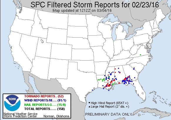
 http://www.spc.noaa.gov/exper/reports/
Pensacola area is about to get wacked http://www.srh.weather.gov/mob/
Last edited by unome on Wed Feb 24, 2016 4:44 am, edited 2 times in total.
-
Katdaddy
- Global Moderator
- Posts: 2502
- Joined: Thu Feb 04, 2010 8:18 am
- Location: League City, Tx
- Contact:
Memories of the afternoon before IKE made landfall with the ongoing TS force wind gusts. Peak gusts so far, Hobby 43MPH, Pearland 41MPH, and Galveston 40MPH. A beautiful evening with a rapidly moving cloud deck. Ongoing significant severe weather event continues across the Deep South
Looks like the models and forecasters busted pretty bad with this last system. The heaviest rain was supposed to be across the NE, but it was actually the opposite, mostly to the SW:
http://www.srh.noaa.gov/images/fxc/hgx/ ... _full1.png
It was obvious they didn't have a handle on the situation, reading the NWS Forecast discussion on Monday night when they said "THE FRONTAL BOUNDARY HAS POSSIBLY STARTED DRIFTING NORTHWARD AT MID EVENING"
And this "STILL LOOKS LIKE THE HEAVIEST RAINFALL WILL BE NORTH OF INTERSTATE 10...ALTHOUGH THE RAP13 WAS
FORECASTING A FURTHER SOUTHWARD TRACK FOR THE SURFACE LOW AND ASSOCIATED RAINFALL."
Yeah, that pretty much busted. It was like they were hanging onto hope from older modeling, when it was apparent the warm front really wasn't advancing as forecast, etc.

I concur. With due respect to their good-faith efforts, I don't think local forecasting is at its pinnacle.jasons wrote:Looks like the models and forecasters busted pretty bad with this last system. The heaviest rain was supposed to be across the NE, but it was actually the opposite, mostly to the SW:
http://www.srh.noaa.gov/images/fxc/hgx/ ... _full1.png
It was obvious they didn't have a handle on the situation, reading the NWS Forecast discussion on Monday night when they said "THE FRONTAL BOUNDARY HAS POSSIBLY STARTED DRIFTING NORTHWARD AT MID EVENING"
And this "STILL LOOKS LIKE THE HEAVIEST RAINFALL WILL BE NORTH OF INTERSTATE 10...ALTHOUGH THE RAP13 WAS
FORECASTING A FURTHER SOUTHWARD TRACK FOR THE SURFACE LOW AND ASSOCIATED RAINFALL."
Yeah, that pretty much busted. It was like they were hanging onto hope from older modeling, when it was apparent the warm front really wasn't advancing as forecast, etc.
It could be that the mandate from the top is to simply translate the model consensus output into words and issue them as the intraday discussion. Subjective disagreement with the endorsed model outputs appear to be scorned.
Going forward, I would love to see more experience-based interpretation of model output, and more "gut feel" calls, at least on 3-7 day forecasts. I would bet that they'd be right more often than not, and would add a ton of credibility to their discussions.
If anyone on this board can convey the feeling to the local NWS office that...we'd rather you give us your real thoughts on the forecast and be very wrong some of the time... versus going with the models and being somewhat wrong most of the time, we chose the former (in my opinion). Private forecast companies came into being because government forecasters can't say what they really think (in my opinion).
Going to be a gorgeous and warm weekend coming up for end of February. Time to put the garden in and get outside and enjoy the weather. Forecast is showing rain starts again on Monday and Tuesday.
zzzzzzzzzzzzzzzzzzzz