djmike wrote:So what does it not moving much mean? More rain to develop eventually? More wrap around? Trying to learn. Thanks.
No, the surface low is still well to the southwest. These features around our region are above the surface for the most part. What it means is less of a flooding concern after this batch moves through.
For Your Infinite Source For All Things Weather Visit Our Facebook
djmike wrote:So what does it not moving much mean? More rain to develop eventually? More wrap around? Trying to learn. Thanks.
No, the surface low is still well to the southwest. These features around our region are above the surface for the most part. What it means is less of a flooding concern after this batch moves through.
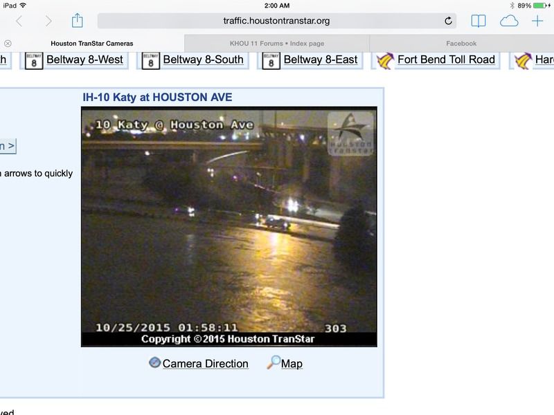
Good job everybody!!! This board did exactly what it was meant to do. I am proud to be apart of it. FWIW I was driving from Sugar Land to Montgomery Texas earlier and that had to be the most treacherous drive I've had in a long time. The heavens seemed to open up right on me.... this was about the same time the Flash Flood Warnings were issued for a large part of SE Texas. Needless to say, I made it to my destination but it sure was an interesting drive.
~~~When Thunder Roars Go Indoors~~~
~~~Turn Around Don't Drown~~~
~~~Run From The Water, Hide From The Wind~~~
rather active pattern across the conus to finish out october both in the east and the west. ensembles continue to advertise a northern/southern stream combo system deepening as it heads from the western great lakes region into canada early in the period... then a splitting trough off the west coast sending a closed low through the four corners region fri-sat... potentially setting up texas for another rainfall event.
western digging troughing will bring widespread but mainly light showers to the great basin and southwest. windy and cooler temperatures will accompany the passage of the upper trough/low. as it swings through az/nm and starts to eject into texas... the gulf may again be tapped for moisture which could bring more rain to areas that have recently received several inches. ensembles show a big signal with their mean qpf in the 2-3 inch range for next sat/sun which is quite high for that lead time. of course... specifics will change but right now the signal is there for heavy rain.
West Gulf low axis should shift east of Houston soon, taking the heavier rain east of here. Only light rain through the next 4-6 hours. HCFCD map indicates 7-9 inches on average across Houston. Heaviest rain was inside the loop where over 9" was measured. My gauge says 7.5" as of 7am. Total for 2015 is 62.7".
I worked this rain event over at Galveston County Office of Emergency Management
Kudos to our NWS, all the agencies, citizens who heeded this event and stayed home
and this wonderful wx. board.....thanks everyone.
Just because you're disabled, you don't have to be a victim
Be Weather Aware & Prepared! Barbara Jordan Winner in Media
Disability Integration Consultant
The low pressure area is moving NE off the Upper TX Coast toward SW LA. Thankfully the intense flooding rains did not materialize over the Houston-Galveston areas last night. Some areas still received up to 8" of rain. We had 5.51" here at the house. Flash Flood Watch still in effect for the immediate coast but will expire later today and high tides continue along the Upper TX Coast. On the backside of the low we can expect gusty 25-35MPH N winds especially along the coastal areas. Already seeing gusts to near TS force along the Middle and SW Upper TX Coast.
So, the total rainfall in my backyard for Oct 24 was only 3 inches at midnight. Since then, as of 8 AM Oct 25, I've recorded another 2 and 3/8 inches. It's definitely slowed down, but today, all of it is running off where only an inch of yesterdays rain here ran off.
Just emptied 6.62 inches of glorious rain out of the old rain bucket in NW Harris County. This was sorely needed for all of the Region. Looking more likely we will add to our Monthly rainfall totals on Halloween as we end the month. Great job everyone! Our online weather community did exactly what it was designed for way back in 2001 and provided good and factual information for our Region. Kudos gang!
Attachments
Carla/Alicia/Jerry(In The Eye)/Michelle/Charley/Ivan/Dennis/Katrina/Rita/Wilma/Humberto/Ike/Harvey
Member: National Weather Association
Facebook.com/Weather Infinity
Twitter @WeatherInfinity
MESOSCALE PRECIPITATION DISCUSSION 0613...CORRECTED
NWS WEATHER PREDICTION CENTER COLLEGE PARK MD
856 AM EDT SUN OCT 25 2015
CORRECTED FOR TYPO IN GRAPHIC
AREAS AFFECTED...SOUTHEAST TX...SOUTHERN LA...SOUTHWESTERN MS
CONCERNING...HEAVY RAINFALL...FLASH FLOODING POSSIBLE
VALID 251233Z - 251533Z
SUMMARY...VERY EFFICIENT WARM RAIN PROCESSES WILL CONTINUE TO POSE
THE THREAT FOR HEAVY RAIN ALONG THE UPPER TX COAST AND SOUTHERN LA
THROUGH THE LATE MORNING HOURS.
DISCUSSION...SURFACE LOW THAT DEVELOPED LATE YESTERDAY INTO THE
OVERNIGHT HOURS OVER THE NORTHWESTERN GULF IN RESPONSE TO ENERGY
FROM PATRICIA LIFTING OUT OF NORTHERN MEXICO IS EXPECTED TO
CONTINUE TO TRACK TO THE EAST AHEAD OF A SOUTHERN STREAM TROUGH
DURING THE MORNING HOURS. 40-50 KT SOUTHEASTERLY 850 MB FLOW
AHEAD OF THE CENTER WILL CONTINUE TO SUPPORT THE ANOMALOUSLY DEEP
MOISTURE ALREADY IN PLACE. LATEST MESOANALYSIS SHOWS PWS OF
2-2.25 INCHES ACROSS THE OUTLOOK AREA. LIMITING FACTOR FOR HEAVY
RAINFALL RATES WILL CONTINUE TO BE MARGINAL TO NEGLIGIBLE
INSTABILITY...WITH THE LATEST MESOANALYSIS SHOWING MUCAPE VALUES
OF 100-500 J/KG ACROSS THE AREA. HOWEVER...THE STRENGTH OF THE LOW
LEVEL INFLOW AND ANOMALOUSLY MOIST PROFILES...WITH ABOVE FREEZING
TEMPERATURES EXTENDING UP TO 4.5-5 KM AGL...AS SHOWN BY THE 12Z
LIX SOUNDING...SUGGEST VERY EFFICIENT WARM RAIN PROCESSES...WHICH
MAY RESULT IN LOCALLY HEAVY AMOUNTS.
THE LATEST HI-RES GUIDANCE CONSENSUS CONFINES THE HEAVIEST AMOUNTS
MAINLY TO THE COASTAL AREAS...WHERE WIDESPREAD ADDITIONAL AMOUNTS
OF 1-2 INCHES AND LOCAL AMOUNTS OF 2-4 INCHES THROUGH 18Z ARE
INDICATED. ONE EXCEPTION MAY BE ACROSS SOUTHEASTERN LA...WHERE A
BAND OF TRAINING CELLS THAT ARE CURRENTLY PRODUCING RAINFALL RATES
OF 1-2 IN/HR MAY EXTEND THE HEAVY RAINFALL FURTHER INLAND INTO
SOUTHWESTERN MS. THE LATEST 3-HR FLASH FLOOD GUIDANCE SUGGESTS
THAT OUTSIDE OF THE HOUSTON-GALVESTON AREA THESE AMOUNTS ARE NOT
LIKELY TO CAUSE WIDESPREAD FLASH FLOODING CONCERNS.
PEREIRA
ATTN...WFO...HGX...JAN...LCH...LIX...
Carla/Alicia/Jerry(In The Eye)/Michelle/Charley/Ivan/Dennis/Katrina/Rita/Wilma/Humberto/Ike/Harvey
Member: National Weather Association
Facebook.com/Weather Infinity
Twitter @WeatherInfinity
Yes sir Srain! More kudos for a job well done by everyone on our KHOU 11 online weather community. Teamwork and solid factual information to inform and warn when weather events threaten. Currently up to 5.68".