TS Erika: East of the Lesser Antilles

Tropical Weather Discussions and Analysis
unome
Posts: 3059
Joined: Fri Feb 12, 2010 6:11 pm

still a tropical storm as of 8 PM

http://www.nhc.noaa.gov/#DANNY

http://www.nhc.noaa.gov/refresh/graphic ... k#contents

hurricane local statement for Puerto Rico http://www.nhc.noaa.gov/text/WTCA82-TJSJ-English.shtml


000
WTNT34 KNHC 232351
TCPAT4

BULLETIN
TROPICAL STORM DANNY INTERMEDIATE ADVISORY NUMBER 22A
NWS NATIONAL HURRICANE CENTER MIAMI FL AL042015
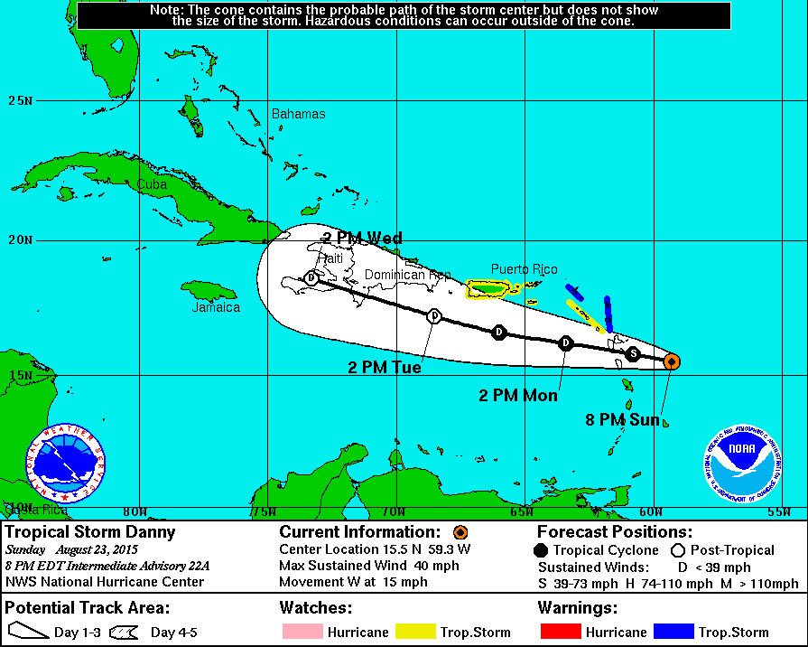
800 PM AST SUN AUG 23 2015

...CENTER OF DANNY EXPECTED TO PASS THROUGH THE SOUTHERN LEEWARD
ISLANDS EARLY MONDAY...


SUMMARY OF 800 PM AST...0000 UTC...INFORMATION
----------------------------------------------
LOCATION...15.5N 59.3W
ABOUT 135 MI...215 KM E OF DOMINICA
ABOUT 150 MI...240 KM ESE OF GUADELOUPE
MAXIMUM SUSTAINED WINDS...40 MPH...65 KM/H
PRESENT MOVEMENT...W OR 265 DEGREES AT 15 MPH...24 KM/H
MINIMUM CENTRAL PRESSURE...1008 MB...29.77 INCHES


WATCHES AND WARNINGS
--------------------
CHANGES WITH THIS ADVISORY:

The Meteorological Service of Antigua has discontinued the Tropical
Storm Warning for Anguilla.

SUMMARY OF WATCHES AND WARNINGS IN EFFECT:

A Tropical Storm Warning is in effect for...
* Antigua, Barbuda, Montserrat, St. Kitts, and Nevis

A Tropical Storm Watch is in effect for...
* Saba and St. Eustatius
* St. Maarten
* Puerto Rico
* Vieques
* Culebra
* U.S. Virgin Islands

For storm information specific to your area in the United
States, including possible inland watches and warnings, please
monitor products issued by your local National Weather Service
forecast office. For storm information specific to your area outside
the United States, please monitor products issued by your national
meteorological service.


DISCUSSION AND 48-HOUR OUTLOOK
------------------------------
At 800 PM AST (0000 UTC), the center of Tropical Storm Danny was
located near latitude 15.5 North, longitude 59.3 West. Danny is
moving toward the west near 15 mph (24 km/h), and a westward to
west-northwestward motion is expected over the next 48 hours. On
the forecast track, the center will move near or over the southern
Leeward Islands late tonight or early Monday, and into the
northeastern Caribbean Sea on Monday.

Maximum sustained winds are near 40 mph (65 km/h) with higher
gusts. Weakening is expected during the next 48 hours, and Danny
is expected to become a tropical depression tonight or Monday.

Tropical storm force winds extend outward up to 60 miles (95 km)
from the center.

The latest minimum central pressure reported by an Air Force
Reserve Hurricane Hunter aircraft is 1008 mb (29.77 inches).


HAZARDS AFFECTING LAND
----------------------
WIND: Tropical storm conditions are expected within portions of the
warning area overnight and early Monday. Tropical storm conditions
are possible elsewhere over the Leeward Islands from Guadeloupe
northward overnight.

RAINFALL: Danny is expected to produce 2 to 4 inches of rain over
the Leeward Islands, the U.S. and British Virgin Islands, and
Puerto Rico through Tuesday.


NEXT ADVISORY
-------------
Next complete advisory at 1100 PM AST.

$$
Forecaster Brown

Image
unome
Posts: 3059
Joined: Fri Feb 12, 2010 6:11 pm

AL, 04, 2015082406, , BEST, 0, 157N, 601W, 35, 1008, TS, 34, NEQ, 50, 30, 0, 0, 1012, 100, 15, 45, 0, L, 0, , 0, 0, DANNY, S,


http://www.nhc.noaa.gov/#DANNY

000
WTNT34 KNHC 240848
TCPAT4

BULLETIN
TROPICAL STORM DANNY ADVISORY NUMBER 24
NWS NATIONAL HURRICANE CENTER MIAMI FL AL042015
500 AM AST MON AUG 24 2015

...DANNY SLOWS DOWN AS IT APPROACHES THE SOUTHERN LEEWARD ISLANDS...


SUMMARY OF 500 AM AST...0900 UTC...INFORMATION
----------------------------------------------
LOCATION...15.8N 60.5W
ABOUT 60 MI...95 KM ENE OF DOMINICA
ABOUT 70 MI...110 KM ESE OF GUADELOUPE
MAXIMUM SUSTAINED WINDS...40 MPH...65 KM/H
PRESENT MOVEMENT...W OR 275 DEGREES AT 9 MPH...15 KM/H
MINIMUM CENTRAL PRESSURE...1007 MB...29.74 INCHES


WATCHES AND WARNINGS
--------------------
CHANGES WITH THIS ADVISORY:

The Meteorological Service of Antigua has discontinued the Tropical
Storm Warning for Antigua, Barbuda, Montserrat, St. Kitts, and
Nevis.

The Meteorological Service of Curacao indicates that a Tropical
Storm Warning is in effect for Saba and St. Eustatius.

SUMMARY OF WATCHES AND WARNINGS IN EFFECT:

A Tropical Storm Warning is in effect for...
* Saba and St. Eustatius

A Tropical Storm Watch is in effect for...
* St. Maarten

For storm information specific to your area in the United States,
including possible inland watches and warnings, please monitor
products issued by your local National Weather Service forecast
office. For storm information specific to your area outside the
United States, please monitor products issued by your national
meteorological service.


DISCUSSION AND 48-HOUR OUTLOOK
------------------------------
At 500 AM AST (0900 UTC), the center of Tropical Storm Danny was
located near latitude 15.8 North, longitude 60.5 West. Danny is
moving toward the west near 9 mph (15 km/h), and a westward to
west-northwestward motion is expected over the next 48 hours. On
the forecast track, the center of Danny will move across the
southern Leeward Islands later this morning and afternoon, and
move into the northeastern Caribbean Sea by this evening.

Reports from a NOAA Hurricane Hunter aircraft indicate that maximum
sustained winds remain near 40 mph (65 km/h) with higher gusts.
Weakening is forecast during the next 48 hours, and Danny is
expected to become a tropical depression by this evening, and
degenerate into a remnant low tonight or on Tuesday.

Tropical-storm-force winds extend outward up to 60 miles (95 km)
from the center.

The latest minimum central pressure reported by NOAA aircraft data
is 1007 mb (29.74 inches).


HAZARDS AFFECTING LAND
----------------------
WIND: Tropical storm conditions are expected within portions of the
warning area this morning. Tropical storm conditions are possible
elsewhere over the Leeward Islands through this morning from
Guadeloupe northward.

RAINFALL: Danny is expected to produce 2 to 4 inches of rain over
the Leeward Islands, the U.S. and British Virgin Islands, and
Puerto Rico through Tuesday.


NEXT ADVISORY
-------------
Next intermediate advisory at 800 AM AST.
Next complete advisory at 1100 AM AST.

$$
Forecaster Stewart
unome
Posts: 3059
Joined: Fri Feb 12, 2010 6:11 pm

http://www.nhc.noaa.gov/#DANNY

an interesting note from Steve Gregory's blog: http://www.wunderground.com/blog/SteveG ... trynum=371

By: Steve Gregory, 1:04 AM GMT on August 24, 2015

Aside from the remarkable ‘life cycle’ of this storm – from rapid intensification to a Major CAT 3 Hurricane - and back down to a weak Depression in a span of barely 72 hours – it’s noteworthy to see several of the typically more reliable hurricane models still calling for DANNY to re-intensify into a Major CAT 3 Hurricane well east of the Carolinas towards the end of the week. (The probabilities of such a development is now well under 5%.)

http://www.hurricanecity.com/models/dat ... atestrun=1
User avatar
wxman57
Global Moderator
Global Moderator
Posts: 2621
Joined: Thu Feb 04, 2010 5:34 am
Location: Southwest Houston (Westbury)
Contact:

And now we're watching TS Erika, east of the Caribbean. I don't see any NW Gulf threat from Erika, but it could be near south Florida in 5-6 days.
Paul Robison

wxman57 wrote:And now we're watching TS Erika, east of the Caribbean. I don't see any NW Gulf threat from Erika, but it could be near south Florida in 5-6 days.
Maybe no NW Gulf threat, but NOLA sure seems worried about Erika. Look at the NOLA HGX disco:

.LONG TERM...
GOING INTO THE WEEKEND MOISTURE RETURNS TO THE AREA AND
TEMPERATURES RECOVER TO NORMAL SUMMERLIKE CONDITIONS. WITH THE
MOISTURE INCREASE WE WILL HAVE TO INTRODUCE A CHANCE OF SHOWERS
AND THUNDERSTORMS THIS WEEKEND INTO EARLY NEXT WEEK. AN UNSETTLED
PATTERN LOOKS TO BE ON TAP FOR EARLY NEXT WEEK AND IS HIGHLY
DEPENDENT ON THE TROPICS AND THE EVENTUAL TRACK OF TROPICAL STORM
ERIKA. 13/MH

Why are they concerned, wxman57?
User avatar
wxman57
Global Moderator
Global Moderator
Posts: 2621
Joined: Thu Feb 04, 2010 5:34 am
Location: Southwest Houston (Westbury)
Contact:

Paul Robison wrote:
Maybe no NW Gulf threat, but NOLA sure seems worried about Erika. Look at the NOLA HGX disco:

.LONG TERM...
GOING INTO THE WEEKEND MOISTURE RETURNS TO THE AREA AND
TEMPERATURES RECOVER TO NORMAL SUMMERLIKE CONDITIONS. WITH THE
MOISTURE INCREASE WE WILL HAVE TO INTRODUCE A CHANCE OF SHOWERS
AND THUNDERSTORMS THIS WEEKEND INTO EARLY NEXT WEEK. AN UNSETTLED
PATTERN LOOKS TO BE ON TAP FOR EARLY NEXT WEEK AND IS HIGHLY
DEPENDENT ON THE TROPICS AND THE EVENTUAL TRACK OF TROPICAL STORM
ERIKA. 13/MH

Why are they concerned, wxman57?
I don't think they're concerned about Erika HITTING New Orleans, but Erika's track near the SE U.S. may affect the weather pattern upstream (Louisiana). We've seen it many times in the past - storm passes to the east of a location and the pattern may change to the west, perhaps driving a cold front south to the Gulf Coast.
ticka1
Posts: 1265
Joined: Wed Feb 03, 2010 3:02 pm
Location: Baytown/Mont Belvieu
Contact:

Email from Jeff Lindner - Wednesday 8/26/2015 - TS Erika

At 500am Tropical Storm Warnings are issued for: the Virgin Islands, Puerto Rico, and the Leeward Islands.

Discussion:
Erika continues to move toward the west and remains poorly organized. Data for several USAF flights yesterday and this morning indicate that the tropical cyclone continues to exhibit shear from the W and NW which is allowing a large mass of dry air to its north to become ingested into the circulation. Additionally the low level surface and mid level centers are not vertically aligned with the mid level center being titled to the south. Deep convection remains mainly focused across the southern semi-circle of the system due to dry air entrainment from the north. Recently deep convection has developed closer to/if not directly over the center. Last center fix from the aircraft indicated a pressure of 1005mb, but that was with a surface wind of 145/6kts…indicating the dropsonde just missed the center and the lowest pressure.

Track:
Track guidance remains in good agreement through the next 48-72 hours with a general W to WNW track along the southern edge of the sub-tropical ridge located over the central Atlantic. This will bring Erika through the Leeward Islands Thursday and to just north of Puerto Rico on Friday and into the SE Bahamas early Saturday. There is decent agreement through 72 hours from the major global forecast models with the exception of the GFDL hurricane forecasting models which continues to track Erika harder toward the right (east) and at a much more significant intensity. Will disregard the GFDL as an outlier for now and follow closely the multi-model consensus track of the ECMWF, GFS, HWRF, and CMC.

Days 4-5:
Spread and uncertainty increases at days 4-5 as Erika reaches the western edge of the sub-tropical ridge over the Atlantic and nears a break in the ridge over the SE US and the eastern Gulf of Mexico. At this time period high latitude ridging begins to build over the NE US states closing the weakness in between the ridges off the SE US coast this weekend…ie the escape route for Erika to turn out to sea will be closing. Think the idea of a recurve east of the Bahamas is now the least likely of the track options given the deep layer ridging expected to develop over the NE US this weekend which will likely effectively block a recurve of Erika. One potential option that would continue to favor a recurve is if Erika was to intensify into a strong hurricane as suggested by the GFDL model.

Will follow the more leftward (west) track guidance in days 4-5 which brings Erika toward the western Bahamas and very close to if not into FL. Given the building 500mb heights over the top of Erika by late this weekend and early next week I suspect some additional model track adjustment westward over the next 24-48 hours. Any additional westward track adjustment will require placing the day 5 forecast point into landfall on the SE FL coast.

This is a good time to remind everyone that the day 5 forecast point has an average error of 240 miles.

Intensity:
Erika is struggling and will continue to struggle in the face of dry air intrusions and shear. While the circulation remains well defined the lack of deep and persistent convection will continue to hinder overall near term development. As with the track…the intensity forecast also has considerable spread in the longer range with the GFS showing almost no development to the GFDL showing a category 4 hurricane. Should Erika survive into the Bahamas, conditions will become increasing favorable for intensification with light upper level winds and better moisture. There is a general consensus that Erika will intensity into a strong tropical storm and possibly a category 1 hurricane as it crosses the Bahamas and nears the SE FL coast late this weekend.

Residents and interests in the Bahamas, the FL Keys, and the FL east coast should closely monitor the progress of Erika over the next several days.
User avatar
wxman57
Global Moderator
Global Moderator
Posts: 2621
Joined: Thu Feb 04, 2010 5:34 am
Location: Southwest Houston (Westbury)
Contact:

Models are trending eastward with Erika. Most have the center passing east of Florida now. That digging upper trof across Texas and the NW/Central Gulf has plunged the jet stream south into the Gulf then NE across Florida. That jet may help turn Erika northward just before the center reaches south Florida. Could keep it east of the Carolinas, too.
User avatar
srainhoutx
Site Admin
Site Admin
Posts: 19616
Joined: Tue Feb 02, 2010 2:32 pm
Location: Maggie Valley, NC
Contact:

Morning briefing from Jeff on Erika:

Erika intensifies slightly.

Tropical Storm Warnings are in effect for: the Leeward Islands, The US/British Virgin Islands, and Puerto Rico

Tropical Storm Watches are in effect for the north coast of the Dominican Republic and the SE Bahama Islands.

Discussion:
Satellite images and aircraft data this morning indicate Erika is attempting to intensify although conditions remain generally unfavorable. A large burst of deep convection has developed overnight near and to the southeast of the fixed surface center as shown by radar data from the Leeward Islands and recon fixes. Erika remains a sheared tropical cyclone with all of the deep convection on the south and southeast side of the circulation. The system has attempted to build deep convection over the center, but 15-20kts of wind shear continue to result in the convection being pushed off the center. With that said, the surface circulation remains well intact at the moment.

Track:
Erika has been moving westward overnight and is currently located over the Leeward Islands. There has been no change to the track forecast reasoning through day 3 with Erika maintaining a WNW motion along the southern side of the sub-tropical ridge over the central Atlantic. Global forecast model data is in good agreement on this track reasoning and brings Erika along the northern coast of the Dominican Republic and then into the SE Bahamas on Saturday. After 72 hours Erika will reach the western edge of the sub-tropical high and begin to slow in forward speed and turn toward the right (north). Track guidance begins to diverge on how fast Erika will turn toward the right and much of this has to do with how strong Erika is and the approach of an upper level trough from the Gulf of Mexico into the SE US. Track guidance has trended eastward since yesterday, but continues to have swings between runs and models which does not result in a very high confidence track for days 4-5. Latest NHC forecast brings Erika NW and then NNW through the Bahamas and then along the FL east coast.

This is a good time to remain everyone that the average error at day 5 is upwards of 240 miles.

Intensity:
Erika will have to continue to fight off 15-30kts of winds shear for at least the next 48 hours given an upper level trough located over the Caribbean Sea west of the circulation. This trough is forecast to weaken over time allowing more favorable conditions as Erika enters the Bahamas on Saturday. The GFDL and HWRF models remain on the higher end of the guidance envelope with the latest HWRF taking Erika down to 948mb (109kts) and the GFDL 928mb and 131kts…both major hurricanes. The rest of the intensity guidance is significantly lower keeping Erika in the strong tropical storm to category 1 hurricane level. If Erika can survive the next 48 hours and find a better environment over the Bahamas gradual intensification is expected. The current forecast calls for Erika to intensify to a category 1 hurricane while passing through the Bahamas.

Residents and interest in the Bahamas, FL and the SE US coast should closely monitor the progress of Erika over the next several days.

NHC Forecast Track and Error Cone:
Attachments
08272015 8 AM EDT Erika 120138W5_NL_sm.gif
08272015 Jeff Erika  tracks unnamed.jpg
Carla/Alicia/Jerry(In The Eye)/Michelle/Charley/Ivan/Dennis/Katrina/Rita/Wilma/Humberto/Ike/Harvey

Member: National Weather Association
Facebook.com/Weather Infinity
Twitter @WeatherInfinity
Paul Robison

Good news?

000
WTNT45 KNHC 290248
TCDAT5

TROPICAL STORM ERIKA DISCUSSION NUMBER 17
NWS NATIONAL HURRICANE CENTER MIAMI FL AL052015
1100 PM EDT FRI AUG 28 2015

Dropsondes from the NOAA P3 flying around Hispaniola were very
helpful in locating the mean center of the broad circulation
associated with Erika, which is moving over the high terrain of
Hispaniola. There is plenty of deep convection associated with the
cyclone, and gusts to tropical storm force are being reported
in Barahona, on the south coast of the Dominican Republic. Given
that the circulation is interacting with land, the initial intensity
has been set at 40 kt. Erika is fighting both land and a hostile
wind shear environment, and it will be very difficult for the
cyclone to recover. Consequently, weakening in the short term is
indicated in the NHC forecast, and there is a strong likelihood
that Erika will degenerate to a tropical wave during its interaction
with land. However, if it survives, there is a very small
opportunity for Erika to regain tropical storm strength in the
Florida Straits and the southeastern Gulf of Mexico, where the
environment is less hostile. It is interesting to note, and to
remember, the fact that most of the state-of-the art dynamical
models were forecasting Erika to become a strong hurricane up to
yesterday, and today basically dissipate the cyclone.
(Yay!)

The initial motion is uncertain, and the best estimate is toward the
west-northwest or 285 degrees at 17 kt. It seems that Erika has
changed very little in forward speed since its formation. However,
the cyclone is reaching the southwestern edge of the subtropical
ridge and the steering currents are weaker. Therefore, Erika is
forecast to slow down and turn to the northwest in about two days.
Once in the eastern Gulf of Mexico, a more northerly track is
anticipated. There is not much track guidance available tonight
since most of the models lose the circulation of Erika, and the NHC
forecast is following the weak perturbation observed in the model
fields.

The greatest short-term threat posed by Erika continues to be very
heavy rainfall over portions of Hispaniola and eastern Cuba. These
rains could produce flash floods and mudslides.

We must emphasize that although this would normally be an
appropriate time for a tropical storm watch for portions of southern
Florida, following typical timelines, we have elected to wait until
we see if Erika survives after it passes Hispaniola. There is a
significant chance that no watches or warnings for Florida will be
required.


FORECAST POSITIONS AND MAX WINDS

INIT 29/0300Z 18.5N 72.9W 40 KT 45 MPH...INLAND
12H 29/1200Z 20.0N 75.0W 35 KT 40 MPH...INLAND
24H 30/0000Z 22.0N 78.0W 30 KT 35 MPH...INLAND
36H 30/1200Z 23.5N 80.5W 30 KT 35 MPH...OVER WATER
48H 31/0000Z 25.0N 82.0W 35 KT 40 MPH
72H 01/0000Z 26.5N 83.0W 35 KT 40 MPH
96H 02/0000Z 28.5N 84.0W 40 KT 45 MPH
120H 03/0000Z 31.0N 84.0W 25 KT 30 MPH...INLAND
User avatar
wxman57
Global Moderator
Global Moderator
Posts: 2621
Joined: Thu Feb 04, 2010 5:34 am
Location: Southwest Houston (Westbury)
Contact:

It sure is quiet in here. The Gulf has just been so hostile for most of the summer. There was only one short period in mid June when the Gulf "opened-up" to deep SE flow, and that's when Bill formed. Meanwhile, remnants of Erika are over the NE Gulf heading NE into Florida. Pressures are high in the region (1017-1018mb) and winds are light (5-10 mph). Any rotation appears to be in the mid levels. Development chances are low, but the remnants may produce some heavy rain across northern Florida today/tomorrow.
Attachments
NEGulf.JPG
Post Reply
  • Information
  • Who is online

    Users browsing this forum: Semrush [Bot] and 50 guests