
JUNE 2015 -Scattered Showers/Storms To End The Month
i like.

My light bill will like this as well.
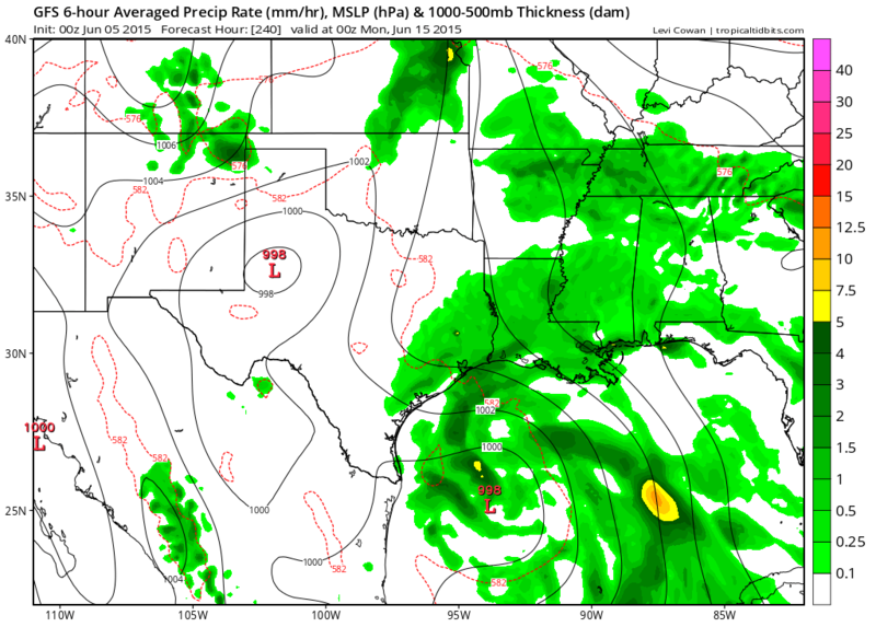
GFS through 240 hours.
Interesting.
Interesting.
-
srainhoutx

- Site Admin

- Posts: 19616
- Joined: Tue Feb 02, 2010 2:32 pm
- Location: Maggie Valley, NC
- Contact:
The 12Z GFS suggests the monsoonal trough and an area of disturbed weather will fester across the Gulf of Tehuantepec (Eastern Pacific) and the Yucatan Peninsula later next week. A very broad area of lower pressures is suggested across the Western Gulf of Mexico into Texas and Louisiana with the Bermuda ridge flexing its muscle across Florida into the Eastern Gulf. A stalled boundary is also suggested by the various computer schemes across Central Texas during this timeframe. We typically see a monsoonal gyre that does occasionally spin up a weak area of tropical trouble, if convection persists this time of year. The global computer models have been insistent is developing an area of disturbed weather for several days and multiple cycles, so we will need to monitor the Western Gulf for the potential of something attempting to develop as we head into next week. Typically these sort of systems are very slow to develop and often meander for several days across this portion of the Western Basin in June and with the pattern expected in the medium to longer range.
Carla/Alicia/Jerry(In The Eye)/Michelle/Charley/Ivan/Dennis/Katrina/Rita/Wilma/Humberto/Ike/Harvey
Member: National Weather Association
Facebook.com/Weather Infinity
Twitter @WeatherInfinity
Member: National Weather Association
Facebook.com/Weather Infinity
Twitter @WeatherInfinity
-
srainhoutx
- Site Admin
- Posts: 19616
- Joined: Tue Feb 02, 2010 2:32 pm
- Location: Maggie Valley, NC
- Contact:
The 12Z European also suggests a broad area of lower pressures across the Western Gulf later next week. The trends continue to support increasing tropical moisture surging N into NE Mexico, Texas and Louisiana.this time next week.
Carla/Alicia/Jerry(In The Eye)/Michelle/Charley/Ivan/Dennis/Katrina/Rita/Wilma/Humberto/Ike/Harvey
Member: National Weather Association
Facebook.com/Weather Infinity
Twitter @WeatherInfinity
Member: National Weather Association
Facebook.com/Weather Infinity
Twitter @WeatherInfinity
-
BiggieSmalls

- Posts: 92
- Joined: Thu Feb 04, 2010 10:05 am
- Location: Dallas, Texas
- Contact:
awful news
I feel like we should just accept that half of the river/lake/beach weekends this summer are going to be rained out
I feel like we should just accept that half of the river/lake/beach weekends this summer are going to be rained out
-
Paul Robison
Rip76 wrote:GFS through 240 hours.
Interesting.
Is the GFS taking it to S TX or SE TX?
-
Texaspirate11

- Posts: 1278
- Joined: Tue Dec 31, 2013 12:24 am
- Contact:
Paul, time will tell. THIS is the time of year you just don't take your eyes off that GOM!Paul Robison wrote:Rip76 wrote:GFS through 240 hours.
Interesting.
Is the GFS taking it to S TX or SE TX?
Just because you're disabled, you don't have to be a victim
Be Weather Aware & Prepared!
Barbara Jordan Winner in Media
Disability Integration Consultant
Be Weather Aware & Prepared!
Barbara Jordan Winner in Media
Disability Integration Consultant
-
srainhoutx
- Site Admin
- Posts: 19616
- Joined: Tue Feb 02, 2010 2:32 pm
- Location: Maggie Valley, NC
- Contact:
Our pleasant weather continues although it may be a bit warm for some throughout the weekend. Temperatures are expected to be near normal for this time of year with highs in the low to mid 90's. The upper ridge will be parked o over Texas into Monday, then changes in the pattern begin to occur.
The upper ridge looks to move SW and flatten out as Blanca moves N into the Baja Peninsula and weakens. Deep tropical moisture will be pooling across the NW Caribbean Sea associated with the monsoonal trough and begins lifting N into the Western Gulf by mid week increasing PW's to a very tropical 2+ inches increasing our rain chances into next weekend. The fly in the ointment continues to be a possible shear axis along the Western Gulf that extends from the Bay of Campeche to NE Mexico, Coastal Texas and Louisiana. This shear axis or area of lower pressures suggests tropical moisture will continue surging N into next weekend and early the following work week. There are indications that a stalled frontal boundary may be draped across Louisiana as a rather strong Eastern trough develops increasing odds for focusing daily showers and thunderstorms. Right now it appears Coastal Texas and Louisiana will see the greatest threat for heavy rainfall, but that will need to be monitored. The GFS has suggested a weak meandering surface low could develop with the other reliable computer guidance waffling day to day with that scenario. At this time it does not appear that conditions are that favorable for any tropical development, but we will continue to monitor just in case any tropical trouble spins up in our backyard.

NWS Lake Charles:
SYNOPSIS...AN UPPER LEVEL RIDGE OF HIGH PRESSURE WILL MAINTAIN A
PATTERN OF LIGHT WINDS AND MOSTLY CLEAR SKIES THROUGH TONIGHT.
SHORT TERM...SLIGHTLY WARMER THAN NORMAL TODAY DUE TO A LACK OF
CLOUD COVER, SUBSIDENCE FROM HIGH PRESSURE ALOFT, AND A LACK OF A
MARINE INFLUENCE TODAY. THIS LACK OF A RETURN FLOW AND HIGH
PRESSURE WILL AGAIN COMBINE TO PRODUCE POOR AIR QUALITY OVER LOWER
SOUTHEAST TEXAS.
LONG TERM...RAIN CHANCES ENTER INTO THE FORECAST BEGINNING LATE
SUNDAY AS GULF MOISTURE BEGINS TO DEEPEN FROM A CONTINUING FETCH
IN THE LOW LEVELS OUT OF THE CARRIBEAN. BY MONDAY HIGH PRESSURE
ALOFT WEAKENS WHILE THE SURFACE HIGH BUILDS OVER THE NORTHEASTERN
GULF...WITH PRECIP CHANCES RETURNING TO CLIMO LEVELS.
AROUND THE MIDDLE OF NEXT WEEK AN UPPER LEVEL TROF MOVES IN FROM
THE NORTHWEST INCREASING INSTABILITY ALOFT AND PRODUCING HIGHER
THAN NORMAL CHANCES FOR THUNDERSTORMS THROUGH THE END OF THE WEEK.
SWEENEY
NWS Houston/Galveston:
MON THROUGH WED MODELS SHOW HIGHER MOISTURE COMING INTO THE
REGION SO MAY SEE SOME SLIGHTLY HIGHER RAIN CHANCES. THE RIDGE
DOES BREAK DOWN TUE/WED NEXT WEEK AS WEEK SHORTWAVE BEGINS TO
CLOSE OFF OVER THE ARKLATEX INTO THE LOWER MISS RIVER VALLEY.
GFS/ECMWF HAVE SOME CONSIDERABLE DIFFERENCES ON WHERE THE WEAK
UPPER LOW MEANDERS ALONG THE N GULF COAST. WHILE THIS HAPPENS GFS
SHOWS PRECIP WATER VALUES INCREASING TO AROUND 1.8-2 INCHES FOR
THE WED THROUGH FRI TIME FRAME. TRAJECTORIES FROM THE CARIBBEAN
SEA INCREASE OVER THE WEEKEND ALLOWING FOR THE POSSIBILITY OF MORE
TROPICAL MOISTURE TO REACH THE AREA FOR NEXT WEEKEND. WHAT THIS
DOES IS OPEN THE POSSIBILITIES OF MORE SCT SHOWER AND THUNDERSTORM
ACTIVITY WED THROUGH NEXT WEEKEND. POPS INCREASE FROM 20/30
PERCENT MON/TUE TO BASICALLY 40 PERCENT FOR THE REST OF THE WEEK.
IF TRENDS WITH MORE TROPICAL MOISTURE COMING INTO THE REGION FOR
THE WEEKEND CONTINUE THEN SUSPECT THAT RAIN CHANCES WILL NEED TO
BE INCREASED GIVEN HIGHER PRECIP WATER VALUES AND A WEAKNESS IN
UPPER LEVEL RIDGING.
The upper ridge looks to move SW and flatten out as Blanca moves N into the Baja Peninsula and weakens. Deep tropical moisture will be pooling across the NW Caribbean Sea associated with the monsoonal trough and begins lifting N into the Western Gulf by mid week increasing PW's to a very tropical 2+ inches increasing our rain chances into next weekend. The fly in the ointment continues to be a possible shear axis along the Western Gulf that extends from the Bay of Campeche to NE Mexico, Coastal Texas and Louisiana. This shear axis or area of lower pressures suggests tropical moisture will continue surging N into next weekend and early the following work week. There are indications that a stalled frontal boundary may be draped across Louisiana as a rather strong Eastern trough develops increasing odds for focusing daily showers and thunderstorms. Right now it appears Coastal Texas and Louisiana will see the greatest threat for heavy rainfall, but that will need to be monitored. The GFS has suggested a weak meandering surface low could develop with the other reliable computer guidance waffling day to day with that scenario. At this time it does not appear that conditions are that favorable for any tropical development, but we will continue to monitor just in case any tropical trouble spins up in our backyard.
NWS Lake Charles:
SYNOPSIS...AN UPPER LEVEL RIDGE OF HIGH PRESSURE WILL MAINTAIN A
PATTERN OF LIGHT WINDS AND MOSTLY CLEAR SKIES THROUGH TONIGHT.
SHORT TERM...SLIGHTLY WARMER THAN NORMAL TODAY DUE TO A LACK OF
CLOUD COVER, SUBSIDENCE FROM HIGH PRESSURE ALOFT, AND A LACK OF A
MARINE INFLUENCE TODAY. THIS LACK OF A RETURN FLOW AND HIGH
PRESSURE WILL AGAIN COMBINE TO PRODUCE POOR AIR QUALITY OVER LOWER
SOUTHEAST TEXAS.
LONG TERM...RAIN CHANCES ENTER INTO THE FORECAST BEGINNING LATE
SUNDAY AS GULF MOISTURE BEGINS TO DEEPEN FROM A CONTINUING FETCH
IN THE LOW LEVELS OUT OF THE CARRIBEAN. BY MONDAY HIGH PRESSURE
ALOFT WEAKENS WHILE THE SURFACE HIGH BUILDS OVER THE NORTHEASTERN
GULF...WITH PRECIP CHANCES RETURNING TO CLIMO LEVELS.
AROUND THE MIDDLE OF NEXT WEEK AN UPPER LEVEL TROF MOVES IN FROM
THE NORTHWEST INCREASING INSTABILITY ALOFT AND PRODUCING HIGHER
THAN NORMAL CHANCES FOR THUNDERSTORMS THROUGH THE END OF THE WEEK.
SWEENEY
NWS Houston/Galveston:
MON THROUGH WED MODELS SHOW HIGHER MOISTURE COMING INTO THE
REGION SO MAY SEE SOME SLIGHTLY HIGHER RAIN CHANCES. THE RIDGE
DOES BREAK DOWN TUE/WED NEXT WEEK AS WEEK SHORTWAVE BEGINS TO
CLOSE OFF OVER THE ARKLATEX INTO THE LOWER MISS RIVER VALLEY.
GFS/ECMWF HAVE SOME CONSIDERABLE DIFFERENCES ON WHERE THE WEAK
UPPER LOW MEANDERS ALONG THE N GULF COAST. WHILE THIS HAPPENS GFS
SHOWS PRECIP WATER VALUES INCREASING TO AROUND 1.8-2 INCHES FOR
THE WED THROUGH FRI TIME FRAME. TRAJECTORIES FROM THE CARIBBEAN
SEA INCREASE OVER THE WEEKEND ALLOWING FOR THE POSSIBILITY OF MORE
TROPICAL MOISTURE TO REACH THE AREA FOR NEXT WEEKEND. WHAT THIS
DOES IS OPEN THE POSSIBILITIES OF MORE SCT SHOWER AND THUNDERSTORM
ACTIVITY WED THROUGH NEXT WEEKEND. POPS INCREASE FROM 20/30
PERCENT MON/TUE TO BASICALLY 40 PERCENT FOR THE REST OF THE WEEK.
IF TRENDS WITH MORE TROPICAL MOISTURE COMING INTO THE REGION FOR
THE WEEKEND CONTINUE THEN SUSPECT THAT RAIN CHANCES WILL NEED TO
BE INCREASED GIVEN HIGHER PRECIP WATER VALUES AND A WEAKNESS IN
UPPER LEVEL RIDGING.
Carla/Alicia/Jerry(In The Eye)/Michelle/Charley/Ivan/Dennis/Katrina/Rita/Wilma/Humberto/Ike/Harvey
Member: National Weather Association
Facebook.com/Weather Infinity
Twitter @WeatherInfinity
Member: National Weather Association
Facebook.com/Weather Infinity
Twitter @WeatherInfinity
-
srainhoutx
- Site Admin
- Posts: 19616
- Joined: Tue Feb 02, 2010 2:32 pm
- Location: Maggie Valley, NC
- Contact:
The 12Z computer guidance continues to advertise increasing rain chances beginning Tuesday and further increasing into next weekend. Long fetch deep tropical moisture from the NW Caribbean Sea surges N into the Western Gulf as a ridge of high pressure builds into the Eastern Gulf and lowering pressures associated with a shear axis, long wave trough advancing from the West and perhaps a weak surface low develops in the Bay of Campeche and slowly meanders N into a week from Monday. At this time no tropical development is expected, but PW's are suggested by the European and GFS computer guidance to increase to a very tropical 2.3 inches which raises an eyebrow and supports heavy rainfall chances particularly across the Upper Texas Coast into Louisiana. We will continue to monitor an area of distributed weather in the Gulf of Tehuantepec and possibly into the Bay of Campeche throughout the coming work week.
- Attachments
-
Carla/Alicia/Jerry(In The Eye)/Michelle/Charley/Ivan/Dennis/Katrina/Rita/Wilma/Humberto/Ike/Harvey
Member: National Weather Association
Facebook.com/Weather Infinity
Twitter @WeatherInfinity
Member: National Weather Association
Facebook.com/Weather Infinity
Twitter @WeatherInfinity
-
Paul Robison
About the Western Gulf late next week? Well, who knows. It will likely depend on the fate of a future system behind Blanca in the Pacific. GFS shunts the energy to the Gulf by day 7. On the other hand, the Euro withholds the energy as it develops a tropical storm on the Pacific side.
The Canadian model is silly with this thing. That one's got the system jumping back and forth across Mexico from 140 hrs forward. The GFS and Euro were in good agreement 10 days out 48 hours earlier. Today, they disagree with each other. I'm not taking the idea of a Gulf storm seriously at this point, having looked at the model runs thus far. I would also wonder about the effect on rainfall rates and moisture if the Euro's scenario verifies. (Think I'll trust the Euro.)
The Canadian model is silly with this thing. That one's got the system jumping back and forth across Mexico from 140 hrs forward. The GFS and Euro were in good agreement 10 days out 48 hours earlier. Today, they disagree with each other. I'm not taking the idea of a Gulf storm seriously at this point, having looked at the model runs thus far. I would also wonder about the effect on rainfall rates and moisture if the Euro's scenario verifies. (Think I'll trust the Euro.)
Last edited by Paul Robison on Sat Jun 06, 2015 7:55 pm, edited 1 time in total.
-
Texaspirate11
- Posts: 1278
- Joined: Tue Dec 31, 2013 12:24 am
- Contact:
Paul Robison wrote:About the Western Gulf late next week? Well, who knows. It will likely depend on the fate of a future system behind Blanca in the Pacific. GFS shunts the energy to the Gulf by day 7. On the other hand, the Euro withholds the energy as it develops a tropical storm on the Pacific side.
The Canadian model is silly with this thing. That one's got the system jumping back and forth across Mexico from 140 hrs forward. The GFS and Euro were in good agreement 10 days out 48 hours earlier. Today, they disagree with each other. I'm not taking the idea of a Gulf storm seriously at this point, having looked at the model runs thus far. I would also wonder about the effect on rainfall rates and moisture if the Euro's scenario verifies. (Think I'll trust the Euro.)
hi Paul! Looks like poor Louisiana would take the weather hit with the rain if this verifies.
But, like you pointed out beautifully; the models today are disagreeing. So, what else is new? HAHA
Seriously, until everything gels (Like Bianca) it's spin the weather wheel, for right now at least.
Remember, its the season for all eyes on The GOM...glad you're on top of it. I suppose the next couple of days,
the models will learn to "get along"...at least for our sanity, right?!
Just because you're disabled, you don't have to be a victim
Be Weather Aware & Prepared!
Barbara Jordan Winner in Media
Disability Integration Consultant
Be Weather Aware & Prepared!
Barbara Jordan Winner in Media
Disability Integration Consultant
-
srainhoutx
- Site Admin
- Posts: 19616
- Joined: Tue Feb 02, 2010 2:32 pm
- Location: Maggie Valley, NC
- Contact:
The overnight global European and GFS continue to advertise a developing trough across the Southern Rockies as well as the potential for a mid/upper low developing across Eastern Texas into Louisiana. Pressures generally continue to lower across the Western Gulf and long fetch deep tropical moisture from the NW Caribbean pushes N into the Western Gulf increasing showers and thunderstorm chances mid weekend into next weekend. There is little agreement day to day regarding any potential surface low pressure development in the Western Gulf, but odds have increased this morning for potential tropical development in the next 48 hours for an area of disturbed weather S of the Gulf of Tehuantepec in the Eastern Pacific. It does appear rain chances will increase throughout the work week and possibly significantly into next weekend regardless of any tropical trouble that may or may not develop in our backyard.
Carla/Alicia/Jerry(In The Eye)/Michelle/Charley/Ivan/Dennis/Katrina/Rita/Wilma/Humberto/Ike/Harvey
Member: National Weather Association
Facebook.com/Weather Infinity
Twitter @WeatherInfinity
Member: National Weather Association
Facebook.com/Weather Infinity
Twitter @WeatherInfinity
-
Paul Robison
You refer to our rain chances, right?srainhoutx wrote:The overnight global European and GFS continue to advertise a developing trough across the Southern Rockies as well as the potential for a mid/upper low developing across Eastern Texas into Louisiana. Pressures generally continue to lower across the Western Gulf and long fetch deep tropical moisture from the NW Caribbean pushes N into the Western Gulf increasing showers and thunderstorm chances mid weekend into next weekend. There is little agreement day to day regarding any potential surface low pressure development in the Western Gulf, but odds have increased this morning for potential tropical development in the next 48 hours for an area of disturbed weather S of the Gulf of Tehuantepec in the Eastern Pacific. It does appear rain chances will increase throughout the work week and possibly significantly into next weekend regardless of any tropical trouble that may or may not develop in our backyard.
-
Texaspirate11
- Posts: 1278
- Joined: Tue Dec 31, 2013 12:24 am
- Contact:
Paul Robison wrote:You refer to our rain chances, right?srainhoutx wrote:The overnight global European and GFS continue to advertise a developing trough across the Southern Rockies as well as the potential for a mid/upper low developing across Eastern Texas into Louisiana. Pressures generally continue to lower across the Western Gulf and long fetch deep tropical moisture from the NW Caribbean pushes N into the Western Gulf increasing showers and thunderstorm chances mid weekend into next weekend. There is little agreement day to day regarding any potential surface low pressure development in the Western Gulf, but odds have increased this morning for potential tropical development in the next 48 hours for an area of disturbed weather S of the Gulf of Tehuantepec in the Eastern Pacific. It does appear rain chances will increase throughout the work week and possibly significantly into next weekend regardless of any tropical trouble that may or may not develop in our backyard.
Yes, Paul, he is. We will all be on the weather watch this week to see what the weekend may bring.
Just because you're disabled, you don't have to be a victim
Be Weather Aware & Prepared!
Barbara Jordan Winner in Media
Disability Integration Consultant
Be Weather Aware & Prepared!
Barbara Jordan Winner in Media
Disability Integration Consultant
-
srainhoutx
- Site Admin
- Posts: 19616
- Joined: Tue Feb 02, 2010 2:32 pm
- Location: Maggie Valley, NC
- Contact:
Our benign weather pattern that we have experienced the last 9 or so days that has allowed our rivers and streams to recede as well as allowed us to warm up to normal temperatures will begin to slowly transition to a wetter pattern by the weekend. The satellite derived data suggested PW's of 2.2 to 2.4 inches is pooling across the Western Caribbean. Meanwhile the upper ridge that has brought our dry weather is slowly moving West into Mexico. Across the Central United States, a boundary stretches from the Central Rockies on East with another upper ridge associated with the Bermuda high is ridging into the Northern Gulf. Blanca continues to weaken an will dissipate bring showers and storms into Arizona and New Mexico.
Later this week as the upper ridge to the West begins to build, a trough of low pressure is expected to develop across the Western and NW Gulf of Mexico as that Western Caribbean moisture begins to surge North into the Western Gulf. That process should be slow to occur as an area of disturbed South of the Gulf of Tehuantepec lifts N to NW and begins to slowly organize into a potential tropical cyclone by the end of the week, The National Hurricane Center is giving the this Eastern Pacific disturbance a High chance (80%) of developing into a tropical cyclone by the end of the work week. This feature will in some part play a roll in our sensible weather along the NW Gulf Coast into Louisiana next weekend. What is expected to happen is rain chances will slowly increase throughout the work week as the Western Caribbean moisture surges N into the Western Gulf. By the end of the week, PW's are expected to increase to 2+ inches particularly along the Middle and Upper Texas Coast into Louisiana. PW's could increase further as the Western/NW Gulf of Mexico trough of low pressure organizes. The is a slight chance that a weak surface low pressure area could form in the Bay of Campeche and meander later this week, but that remains to be seen. Should a broad weak area of low pressure develop, it could further enhance our rain chances and possibly bring rounds of very heavy tropical rainfall along the Upper Texas Coast into Louisiana. The computer models are struggling with the various features, so expect a lot of day to day changes as the work week unfolds.
The fly in the ointment will be a stalling boundary associated with a deepening upper trough across the Southern Rockies into Northern Mexico next weekend which further complicates an already complex and complicated forecast.
INVEST 94E S of the Gulf of Tehuantepec:
Later this week as the upper ridge to the West begins to build, a trough of low pressure is expected to develop across the Western and NW Gulf of Mexico as that Western Caribbean moisture begins to surge North into the Western Gulf. That process should be slow to occur as an area of disturbed South of the Gulf of Tehuantepec lifts N to NW and begins to slowly organize into a potential tropical cyclone by the end of the week, The National Hurricane Center is giving the this Eastern Pacific disturbance a High chance (80%) of developing into a tropical cyclone by the end of the work week. This feature will in some part play a roll in our sensible weather along the NW Gulf Coast into Louisiana next weekend. What is expected to happen is rain chances will slowly increase throughout the work week as the Western Caribbean moisture surges N into the Western Gulf. By the end of the week, PW's are expected to increase to 2+ inches particularly along the Middle and Upper Texas Coast into Louisiana. PW's could increase further as the Western/NW Gulf of Mexico trough of low pressure organizes. The is a slight chance that a weak surface low pressure area could form in the Bay of Campeche and meander later this week, but that remains to be seen. Should a broad weak area of low pressure develop, it could further enhance our rain chances and possibly bring rounds of very heavy tropical rainfall along the Upper Texas Coast into Louisiana. The computer models are struggling with the various features, so expect a lot of day to day changes as the work week unfolds.
The fly in the ointment will be a stalling boundary associated with a deepening upper trough across the Southern Rockies into Northern Mexico next weekend which further complicates an already complex and complicated forecast.
Carla/Alicia/Jerry(In The Eye)/Michelle/Charley/Ivan/Dennis/Katrina/Rita/Wilma/Humberto/Ike/Harvey
Member: National Weather Association
Facebook.com/Weather Infinity
Twitter @WeatherInfinity
Member: National Weather Association
Facebook.com/Weather Infinity
Twitter @WeatherInfinity
-
srainhoutx
- Site Admin
- Posts: 19616
- Joined: Tue Feb 02, 2010 2:32 pm
- Location: Maggie Valley, NC
- Contact:
The Weather Predication Center afternoon updated surface charts for Day 3 through 7 suggest a trough across the Western Gulf and possibly an area of low pressure meandering in the Bay of Campeche.
- Attachments
-
Carla/Alicia/Jerry(In The Eye)/Michelle/Charley/Ivan/Dennis/Katrina/Rita/Wilma/Humberto/Ike/Harvey
Member: National Weather Association
Facebook.com/Weather Infinity
Twitter @WeatherInfinity
Member: National Weather Association
Facebook.com/Weather Infinity
Twitter @WeatherInfinity
Thanks for all the updates! I have friends and family that are still unable to go home because of the Trinity River being so high. So, all of the information is greatly appreciated!