


Finally, some nice weather (i.e., not flooding). Got out and washed my car yesterday, knowing It would be more than an hour before the next storm. While washing the car I heard a bunch of bluejays making a big racket across the street in a couple of pine trees. Heard something else in the tree that sounded like a monkey. I was going to walk over and see what it was when a large gray bird flew out of the pine tree and into our backyard oak tree. It was a large gray bird about the size of a parrot. Thought it might be a gray parrot at first. The bird flew back into the pine tree and began making the strange sounds again. The sounds were oddly familiar - I'd heard that bird before. Then I remembered - in a Tarzan movie! It's the standard jungle bird sound heard in all the movies, but it's not from Africa. It's an Australian kookaburra. I hear that many in the U.S. have them as pets. I guess one escaped.
Here's a video of a kookaburra singing. You'll recognize the bird. I suppose it was fitting, given all the rain of late. My yard was becoming a jungle...
https://www.google.com/search?q=kookabu ... 8&oe=utf-8
JUNE 2015 -Scattered Showers/Storms To End The Month
-
srainhoutx

- Site Admin

- Posts: 19616
- Joined: Tue Feb 02, 2010 2:32 pm
- Location: Maggie Valley, NC
- Contact:
Dry weather looks to remain in the forecast as the upper ridge will build across our Region. The pattern appears to hold into the weekend, then changes may be lurking as we start the beginning of next week. The upper ridge is suggested to flatten out and shift West by the various computer guidance. Beyond the medium range, the European and to some extent the GFS are showing a possible area of lower pressure crossing from the Gulf of Tehuantepec into the Bay of Campeche. This is still well beyond a week away and a lot can change as we well know. Stay Tuned!
Convectively Couple Kelvin Wave:
MJO: (Wet Phase)
Euro:
GFS:
Convectively Couple Kelvin Wave:
Carla/Alicia/Jerry(In The Eye)/Michelle/Charley/Ivan/Dennis/Katrina/Rita/Wilma/Humberto/Ike/Harvey
Member: National Weather Association
Facebook.com/Weather Infinity
Twitter @WeatherInfinity
Member: National Weather Association
Facebook.com/Weather Infinity
Twitter @WeatherInfinity
-
BlueJay
- Posts: 938
- Joined: Tue Mar 04, 2014 10:47 am
- Location: Alden Bridge-The Woodlands, Texas
- Contact:
What a treat, wxman57, to have a kookaburra in your neighborhood. I hope it will be OK.
We have a large family of American crows living in our neighborhood this spring. Their call is not as pleasing as the kookaburra but I have been enjoying watching them.
-
Paul Robison
[quote="srainhoutx"]Dry weather looks to remain in the forecast as the upper ridge will build across our Region. The pattern appears to hold into the weekend, then changes may be lurking as we start the beginning of next week. The upper ridge is suggested to flatten out and shift West by the various computer guidance. Beyond the medium range, the European and to some extent the GFS are showing a possible area of lower pressure crossing from the Gulf of Tehuantepec into the Bay of Campeche. This is still well beyond a week away and a lot can change as we well know. Stay Tuned!
I personally don't trust the Euro 10 days out. The last frame shows that low in the BOC forming out of virtually nothing in the GOT, crossing Mexico, and ending up in the BOC. I was talking about that with a WX expert at the NOAA weather station at HBU; he tells me that's a very unlikely scenario, and he went on to say that, being 10 days out makes it even more unlikely. But, hey, I'll stay tuned. I figure at the very least it'll just shunt tropical moisture to our state, something we don't need right now, or so Eric Berger said once.
P.S.
Some would wonder (like me) if this would be a southeast tx storm? Or a deep south tx storm if it developed. The reality is that there's no way to know this far out and there's no storm yet. It's still in the model watching stage at this point.
-
srainhoutx
- Site Admin
- Posts: 19616
- Joined: Tue Feb 02, 2010 2:32 pm
- Location: Maggie Valley, NC
- Contact:
The 12Z GFS suggests the monsoonal trough will continue to slowly lift N into Southern Mexico, into the Bay of Campeche and the NW Caribbean Sea in the medium range. While Major Hurricane Blanca is expected to impact Los Cabos and the Baja Peninsula in a weakening state, heavy rainfall is suggested to develop across Mexico (particularly the higher terrain) into Arizona and New Mexico. The upper ridge that has allowed us to dry out after a very wet March, April and May looks to flatten out and shift W after the remnants of Blanca move inland and dissipate. This opens the door to a 'wetter' pattern as a rather deep Eastern trough develops and pressures lower in response to the monsoonal trough across the NW Caribbean and Gulf of Mexico. A broad monsoonal gyre is suggested by the GFS to set up shop over the Yucatan Peninsula later next week as tropical moisture begins to approach the Texas and Louisiana Coast.
- Attachments
-
-
Carla/Alicia/Jerry(In The Eye)/Michelle/Charley/Ivan/Dennis/Katrina/Rita/Wilma/Humberto/Ike/Harvey
Member: National Weather Association
Facebook.com/Weather Infinity
Twitter @WeatherInfinity
Member: National Weather Association
Facebook.com/Weather Infinity
Twitter @WeatherInfinity
-
srainhoutx
- Site Admin
- Posts: 19616
- Joined: Tue Feb 02, 2010 2:32 pm
- Location: Maggie Valley, NC
- Contact:
The 12Z European remains onboard with the monsoonal trough lifting N with an area of disturbed weather near the Gulf of Tehuantepec. A broad monsoonal gyre (broad mid level/surface low pressure) is indicated as well. Pressures also are suggested to begin falling across the NW Caribbean and the Western Gulf indicating tropical moisture may well be headed N.
- Attachments
-
Carla/Alicia/Jerry(In The Eye)/Michelle/Charley/Ivan/Dennis/Katrina/Rita/Wilma/Humberto/Ike/Harvey
Member: National Weather Association
Facebook.com/Weather Infinity
Twitter @WeatherInfinity
Member: National Weather Association
Facebook.com/Weather Infinity
Twitter @WeatherInfinity
-
srainhoutx
- Site Admin
- Posts: 19616
- Joined: Tue Feb 02, 2010 2:32 pm
- Location: Maggie Valley, NC
- Contact:
New Drought Index is out and as expected we have made significant gains across the Lone Star State of ending the multi year drought that peaked in 2011.
- Attachments
-
Carla/Alicia/Jerry(In The Eye)/Michelle/Charley/Ivan/Dennis/Katrina/Rita/Wilma/Humberto/Ike/Harvey
Member: National Weather Association
Facebook.com/Weather Infinity
Twitter @WeatherInfinity
Member: National Weather Association
Facebook.com/Weather Infinity
Twitter @WeatherInfinity
-
srainhoutx
- Site Admin
- Posts: 19616
- Joined: Tue Feb 02, 2010 2:32 pm
- Location: Maggie Valley, NC
- Contact:
The overnight ensemble guidance is suggesting the upper ridge will temporarily build across New Mexico and Texas Friday into Saturday, but as Blanca makes its approach toward the Baja Peninsula the upper ridge will flatten out and move West. Isolated showers and storms begin to increase next week as the upper flow allows night time convection along a weak frontal boundary draped across Kansas and the Mid Mississippi Valley to head SE. There are still some indications that the monsoonal trough will continue lifting N into Mexico and the Bay of Campeche as well as the NW Caribbean Sea which is typical for this time of year. That additional tropical moisture lifting N may add additional rain chance later next week as a very broad and disorganized area of tropical showers and storms develop across the Gulf of Mexico. Conditions do not appear conducive for any tropical development in the Gulf at this time for next week. I've seen some chatter about a dry pattern developing that could allow drought continues to re establish. That does not appear likely in this pattern as our wet soils from 3 months of drought busting rainfall will not allow a 'drought feedback process' to become established. This looks much more like a typical Summer across the Region that some may have forgotten about since the multi year drought began back in late 2008... 

Carla/Alicia/Jerry(In The Eye)/Michelle/Charley/Ivan/Dennis/Katrina/Rita/Wilma/Humberto/Ike/Harvey
Member: National Weather Association
Facebook.com/Weather Infinity
Twitter @WeatherInfinity
Member: National Weather Association
Facebook.com/Weather Infinity
Twitter @WeatherInfinity
-
srainhoutx
- Site Admin
- Posts: 19616
- Joined: Tue Feb 02, 2010 2:32 pm
- Location: Maggie Valley, NC
- Contact:
The 12Z European and GFS continue to suggest a surge of tropical moisture associated with a tropical disturbance/wave of low pressure arriving into the Western Gulf later next week with lower pressures aloft increasing across Texas and portions of Western Louisiana. The global guidance is also suggesting higher pressures across Florida and the Eastern Gulf of Mexico.
- Attachments
-
Carla/Alicia/Jerry(In The Eye)/Michelle/Charley/Ivan/Dennis/Katrina/Rita/Wilma/Humberto/Ike/Harvey
Member: National Weather Association
Facebook.com/Weather Infinity
Twitter @WeatherInfinity
Member: National Weather Association
Facebook.com/Weather Infinity
Twitter @WeatherInfinity
-
srainhoutx
- Site Admin
- Posts: 19616
- Joined: Tue Feb 02, 2010 2:32 pm
- Location: Maggie Valley, NC
- Contact:
Climate.gov updated their June forecast today suggesting cooler than normal temperatures and a return to a 'wetter' pattern across our Region.
http://www.climate.gov/news-features/fe ... ns-updated#
http://www.climate.gov/news-features/fe ... ns-updated#
- Attachments
-
Carla/Alicia/Jerry(In The Eye)/Michelle/Charley/Ivan/Dennis/Katrina/Rita/Wilma/Humberto/Ike/Harvey
Member: National Weather Association
Facebook.com/Weather Infinity
Twitter @WeatherInfinity
Member: National Weather Association
Facebook.com/Weather Infinity
Twitter @WeatherInfinity
i like.

My light bill will like this as well.
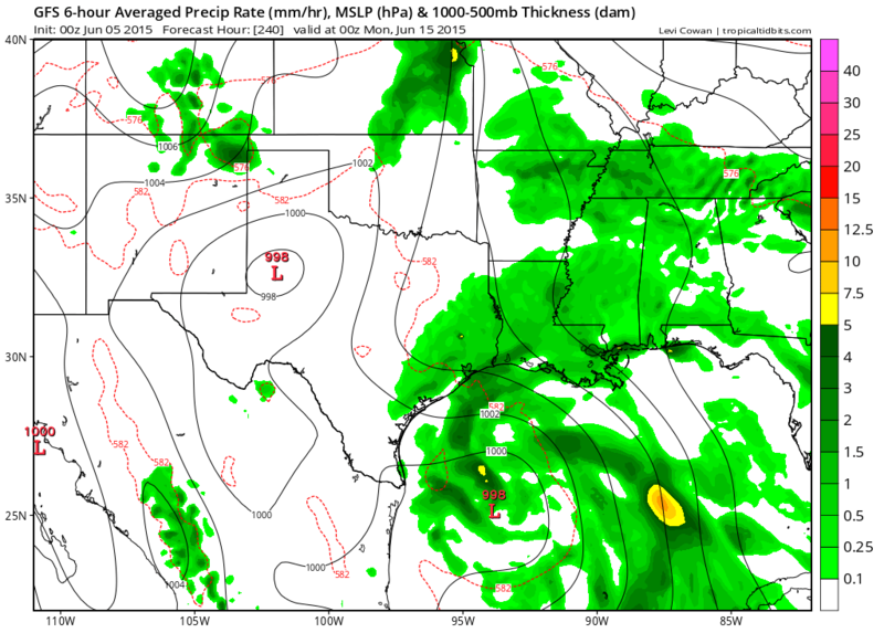
GFS through 240 hours.
Interesting.
Interesting.
-
srainhoutx
- Site Admin
- Posts: 19616
- Joined: Tue Feb 02, 2010 2:32 pm
- Location: Maggie Valley, NC
- Contact:
The 12Z GFS suggests the monsoonal trough and an area of disturbed weather will fester across the Gulf of Tehuantepec (Eastern Pacific) and the Yucatan Peninsula later next week. A very broad area of lower pressures is suggested across the Western Gulf of Mexico into Texas and Louisiana with the Bermuda ridge flexing its muscle across Florida into the Eastern Gulf. A stalled boundary is also suggested by the various computer schemes across Central Texas during this timeframe. We typically see a monsoonal gyre that does occasionally spin up a weak area of tropical trouble, if convection persists this time of year. The global computer models have been insistent is developing an area of disturbed weather for several days and multiple cycles, so we will need to monitor the Western Gulf for the potential of something attempting to develop as we head into next week. Typically these sort of systems are very slow to develop and often meander for several days across this portion of the Western Basin in June and with the pattern expected in the medium to longer range.
Carla/Alicia/Jerry(In The Eye)/Michelle/Charley/Ivan/Dennis/Katrina/Rita/Wilma/Humberto/Ike/Harvey
Member: National Weather Association
Facebook.com/Weather Infinity
Twitter @WeatherInfinity
Member: National Weather Association
Facebook.com/Weather Infinity
Twitter @WeatherInfinity
-
srainhoutx
- Site Admin
- Posts: 19616
- Joined: Tue Feb 02, 2010 2:32 pm
- Location: Maggie Valley, NC
- Contact:
The 12Z European also suggests a broad area of lower pressures across the Western Gulf later next week. The trends continue to support increasing tropical moisture surging N into NE Mexico, Texas and Louisiana.this time next week.
Carla/Alicia/Jerry(In The Eye)/Michelle/Charley/Ivan/Dennis/Katrina/Rita/Wilma/Humberto/Ike/Harvey
Member: National Weather Association
Facebook.com/Weather Infinity
Twitter @WeatherInfinity
Member: National Weather Association
Facebook.com/Weather Infinity
Twitter @WeatherInfinity
-
BiggieSmalls

- Posts: 92
- Joined: Thu Feb 04, 2010 10:05 am
- Location: Dallas, Texas
- Contact:
awful news
I feel like we should just accept that half of the river/lake/beach weekends this summer are going to be rained out
I feel like we should just accept that half of the river/lake/beach weekends this summer are going to be rained out
-
Paul Robison
Rip76 wrote:GFS through 240 hours.
Interesting.
Is the GFS taking it to S TX or SE TX?
-
Texaspirate11

- Posts: 1278
- Joined: Tue Dec 31, 2013 12:24 am
- Contact:
Paul, time will tell. THIS is the time of year you just don't take your eyes off that GOM!Paul Robison wrote:Rip76 wrote:GFS through 240 hours.
Interesting.
Is the GFS taking it to S TX or SE TX?
Just because you're disabled, you don't have to be a victim
Be Weather Aware & Prepared!
Barbara Jordan Winner in Media
Disability Integration Consultant
Be Weather Aware & Prepared!
Barbara Jordan Winner in Media
Disability Integration Consultant
-
- Information
-
Who is online
Users browsing this forum: Ahrefs [Bot], Amazon [Bot], Semrush [Bot] and 50 guests