
now 40/50% over 2/5 days
http://www.nhc.noaa.gov/text/refresh/MI ... WOAT.shtml
00
ABNT20 KNHC 131737
TWOAT
TROPICAL WEATHER OUTLOOK
NWS NATIONAL HURRICANE CENTER MIAMI FL
200 PM EDT SAT JUN 13 2015
For the North Atlantic...Caribbean Sea and the Gulf of Mexico:
A broad area of low pressure over northern Belize and the Yucatan
peninsula is producing a large area of showers and thunderstorms and
winds to near gale force over the northwestern Caribbean Sea.
Environmental conditions should support some development of this
system when it moves over the southwestern Gulf of Mexico by
tomorrow night and across the northwestern Gulf of Mexico through
Tuesday. Regardless of development, heavy rains are possible over
the Yucatan peninsula during the next day or so. Additional
information on this system can be found in High Seas Forecasts
issued by the National Weather Service.
* Formation chance through 48 hours...medium...40 percent
* Formation chance through 5 days...medium...50 percent
&&
High Seas Forecasts can be found under AWIPS header NFDHSFAT1 and
WMO header FZNT01 KWBC.
$$
Forecaster Cangialosi/Blake
JUNE 2015 -Scattered Showers/Storms To End The Month
Last edited by srainhoutx on Sat Jun 13, 2015 12:44 pm, edited 1 time in total.
Reason: Add Attached Image
Reason: Add Attached Image
-
srainhoutx

- Site Admin

- Posts: 19620
- Joined: Tue Feb 02, 2010 2:32 pm
- Location: Maggie Valley, NC
- Contact:
Briefing from Jeff issued just prior to the 1 PM CDT Tropical Weather Outlook was issued:
Global model solution continue to suggest possible tropical cyclone formation over the Gulf of Mexico early next week in association with an upper level trough and tropical wave currently over the western Caribbean Sea.
There has been little change overnight and now the 3rd run of models suggesting the potential for development in the western Gulf of Mexico from late Sunday into Tuesday. While upper level conditions appear marginal at best, the western Gulf is notorious for highly sheared tropical systems. The pattern setup is very similar to TS Allison (2001). The National Hurricane Center is currently monitoring the area and indicates a 30% chance of development potential over the Gulf of Mexico early next week…up from 10% last evening. Given the model support the chances may be higher than 30%.
Steering pattern is fairly straight forward that any development will move toward the WNW to NW toward the NW Gulf coast. Tremendous influx of Caribbean tropical moisture is already underway and any development of a tropical system will only help to focus and enhance an already highly wet forecast. The flooding potential is certainly increasing with potential rainfall amounts over the next 5-7 days approaching 5-8 inches over the region south of I-10. Isolated totals of up to 10 inches or greater is certainly possible.
Tides are already running .5-1.0 feet above normal and increasing ESE fetch will only increase them more going into Monday…possibly up to 2.0 ft. Global model tracks of potential surface low formation across our coastal waters next week would suggest increasing coastal impacts as early as Tuesday especially with tides and wave action. Will need to keep a close eye on tides if any tropical system forms to our south/southwest as we could get close to 4.0 ft along the Gulf beaches and in the bay for coastal flooding.
Note: El Nino summers support such short duration tropical development in the western Gulf of Mexico.
Carla/Alicia/Jerry(In The Eye)/Michelle/Charley/Ivan/Dennis/Katrina/Rita/Wilma/Humberto/Ike/Harvey
Member: National Weather Association
Facebook.com/Weather Infinity
Twitter @WeatherInfinity
Member: National Weather Association
Facebook.com/Weather Infinity
Twitter @WeatherInfinity
-
srainhoutx
- Site Admin
- Posts: 19620
- Joined: Tue Feb 02, 2010 2:32 pm
- Location: Maggie Valley, NC
- Contact:
Update from Jeff:
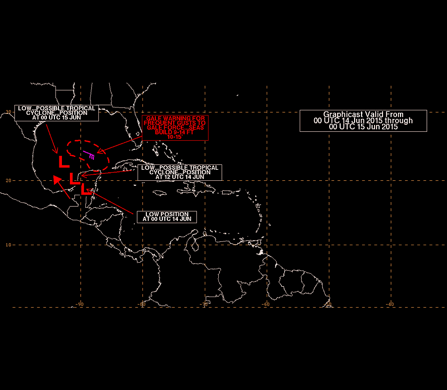
National Hurricane Center has declared the area of weather over the Yucatan as invest 91L.
Visible satellite images along with Mexican radars show the formation of a broad low level circulation over the Yucatan this morning along with an increase in showers and thunderstorms. While conditions over the Gulf of Mexico will be marginally favorable for development, it appears the potential is increasing for the formation of a tropical depression/storm from Sunday into early next week with a general track toward the NW Gulf coast.
NHC has tasked an air force flight for Monday.
Given the model support and ongoing satellite development, think chances for the formation of a tropical system in the Gulf and impact to the Texas coast is increasing.
Will need to take a hard look at tides for early next week as we may get near the critical 4.0 ft levels to cause coastal flood issues. Excessive rainfall threat is certainly increasing with several models really pinging the upper TX coast with some very impressive rainfall amounts.
Residents along the TX coast should closely monitor the forecasts over the next 1-2 days as significant changes are becoming increasingly likely.
- Attachments
-
Carla/Alicia/Jerry(In The Eye)/Michelle/Charley/Ivan/Dennis/Katrina/Rita/Wilma/Humberto/Ike/Harvey
Member: National Weather Association
Facebook.com/Weather Infinity
Twitter @WeatherInfinity
Member: National Weather Association
Facebook.com/Weather Infinity
Twitter @WeatherInfinity
-
srainhoutx
- Site Admin
- Posts: 19620
- Joined: Tue Feb 02, 2010 2:32 pm
- Location: Maggie Valley, NC
- Contact:
The 12Z European has come into agreement with the GFS and Canadian computer guidance suggesting a landfalling TD or weak TS along the Middle Texas Coast on Tuesday into Wednesday. The European also suggests heavy flooding rainfall across the SE Texas and SW Louisiana areas.
- Attachments
-
-
Carla/Alicia/Jerry(In The Eye)/Michelle/Charley/Ivan/Dennis/Katrina/Rita/Wilma/Humberto/Ike/Harvey
Member: National Weather Association
Facebook.com/Weather Infinity
Twitter @WeatherInfinity
Member: National Weather Association
Facebook.com/Weather Infinity
Twitter @WeatherInfinity
-
srainhoutx
- Site Admin
- Posts: 19620
- Joined: Tue Feb 02, 2010 2:32 pm
- Location: Maggie Valley, NC
- Contact:
18Z Track and Intensity guidance for 91L.
- Attachments
-
-
Carla/Alicia/Jerry(In The Eye)/Michelle/Charley/Ivan/Dennis/Katrina/Rita/Wilma/Humberto/Ike/Harvey
Member: National Weather Association
Facebook.com/Weather Infinity
Twitter @WeatherInfinity
Member: National Weather Association
Facebook.com/Weather Infinity
Twitter @WeatherInfinity
from the Marine Forecasts & Analysis section on NHC's page: http://www.nhc.noaa.gov/marine/
24, 48 & 72 hr Surface Forecasts
(Purpose/Content/Coverage/Issuance: http://www.nhc.noaa.gov/abouttafbprod.s ... RFACEFCSTS )


24, 48 & 72 hr Surface Forecasts
(Purpose/Content/Coverage/Issuance: http://www.nhc.noaa.gov/abouttafbprod.s ... RFACEFCSTS )
-
srainhoutx
- Site Admin
- Posts: 19620
- Joined: Tue Feb 02, 2010 2:32 pm
- Location: Maggie Valley, NC
- Contact:
The afternoon Updated Quantitative Precipitation Forecast from the Weather Prediction Center for the next 5 days. Expect changes if 91L develops into a tropical depression or weak tropical storm. The GFS/NAM solutions today were about 12 hours faster pushing this disturbance onshore with the European and GEM (Canadian) about 12 hours slower allowing for a bit more potential of heavier rainfall.
- Attachments
-
Carla/Alicia/Jerry(In The Eye)/Michelle/Charley/Ivan/Dennis/Katrina/Rita/Wilma/Humberto/Ike/Harvey
Member: National Weather Association
Facebook.com/Weather Infinity
Twitter @WeatherInfinity
Member: National Weather Association
Facebook.com/Weather Infinity
Twitter @WeatherInfinity
-
Andrew
- Site Admin
- Posts: 3440
- Joined: Wed Feb 03, 2010 9:46 pm
- Location: North-West Houston
- Contact:
Latest satellite presentation and analysis indicate that low level convergence continues to increase while upper level anticyclonic flow creates a nice ventilation of the system. Concerning to see some of the organization processes that are occurring sooner than anticipated. I really think that with shear continuing to relax and organization improving, a TD could be declared sometime tomorrow. SHIPS still indicate that a moderate TS could be possible during landfall. Either way plenty of moisture and rain will filter into the region causing numerous issues. Latest ECMWF run indicated that upwards of 10-15 inches could be possible.
For Your Infinite Source For All Things Weather Visit Our Facebook

If this were to spin up quicker than forecast, would it then tend to move in a more northward direction?

Northern Gulf storms tend to come in to the right of the guidance/models.
Recon flight added Sunday http://www.nhc.noaa.gov/text/MIAREPRPD.shtml
000
NOUS42 KNHC 132000
REPRPD
WEATHER RECONNAISSANCE FLIGHTS
CARCAH, NATIONAL HURRICANE CENTER, MIAMI, FL.
0400 PM EDT SAT 13 JUNE 2015
SUBJECT: TROPICAL CYCLONE PLAN OF THE DAY (TCPOD)
VALID 14/1100Z TO 15/1100Z JUNE 2015
TCPOD NUMBER.....15-019 AMENDMENT
I. ATLANTIC REQUIREMENTS......MISSION ADDED
1. SUSPECT AREA - NEAR YUCATAN PENINSULA
FLIGHT ONE -- TEAL 71
A. 14/1800Z
B. AFXXX 01BBA INVEST
C. 14/1530Z
D. 22.0N 91.0W
E. 14/1730Z TO 14/2100Z
F. SFC TO 10,000 FT
G. RESOURCES PERMITTING
2. OUTLOOK FOR SUCCEEDING DAY.....CHANGED - IF
SYSTEM DEVELOPS, CONTINUE 6-HRLY FIXES BEGINNING
AT 15/1200Z.
II. PACIFIC REQUIREMENTS
1. NEGATIVE RECONNAISSANCE REQUIREMENTS.
2. SUCCEEDING DAY OUTLOOK.....FIX HURRICANE CARLOS
AT 15/1730Z NEAR 17.5N 103.5W.
$$
WJM
-
Paul Robison
Texas Storm Chasers emphasizes that NONE of these models (at this time) develop it into a hurricane or anything other than a tropical low with increased heavy rain chances.
Last edited by Paul Robison on Sat Jun 13, 2015 7:09 pm, edited 2 times in total.
-
srainhoutx
- Site Admin
- Posts: 19620
- Joined: Tue Feb 02, 2010 2:32 pm
- Location: Maggie Valley, NC
- Contact:
Chances for development of 91L into a Tropical Depression continue to slowly increase.
TROPICAL WEATHER OUTLOOK
NWS NATIONAL HURRICANE CENTER MIAMI FL
800 PM EDT SAT JUN 13 2015
For the North Atlantic...Caribbean Sea and the Gulf of Mexico:
1. An area of low pressure located over the Yucatan Peninsula is
producing a large area of showers and thunderstorms and winds to
near gale force over portions of the northwestern Caribbean Sea and
southeastern Gulf of Mexico as it interacts with an upper-level
trough. Environmental conditions should support some development of
this system after it moves over the southwestern Gulf of Mexico
Sunday and across the northwestern Gulf of Mexico through Tuesday.
Regardless of development, heavy rains are possible over portions of
the Yucatan Peninsula through Sunday. An Air Force Reserve
Hurricane Hunter aircraft is scheduled to investigate this system
Sunday afternoon, if necessary. Additional information on this
system can be found in High Seas Forecasts issued by the National
Weather Service.
* Formation chance through 48 hours...medium...50 percent
* Formation chance through 5 days...medium...60 percent
High Seas Forecasts can be found under AWIPS header NFDHSFAT1 and
WMO header FZNT01 KWBC.
Forecaster Brennan
- Attachments
-
-
Carla/Alicia/Jerry(In The Eye)/Michelle/Charley/Ivan/Dennis/Katrina/Rita/Wilma/Humberto/Ike/Harvey
Member: National Weather Association
Facebook.com/Weather Infinity
Twitter @WeatherInfinity
Member: National Weather Association
Facebook.com/Weather Infinity
Twitter @WeatherInfinity
I know it's hard to say with weak systems, but since this one will be somewhere relatively quickly, what's your best hunch everyone?
No rain, no rainbows.
-
Paul Robison
cisa wrote:I know it's hard to say with weak systems, but since this one will be somewhere relatively quickly, what's your best hunch everyone?
To answer your question, Cisa:
1. Factors favoring this disturbance developing further include already lower than normal surface pressures, ample low level moisture and the warm waters of the southern Gulf of Mexico.
2.)Inhibiting factors include some wind shear aloft and the presence of dry air aloft over much of the western Gulf.
3. Indications are that the low will move rather quickly to the Texas coast, reaching it sometime late Monday or early Tuesday. Until a center actually forms in the Gulf, there is much uncertainty where landfall might be. Computer model forecasts from Saturday morning would place the most likely landfall anywhere from south of Corpus Christi to near Galveston.
4.The same models indicate that the dry air aloft and wind shear should prevent significant development of the system during the short time it will be over the Gulf.
5.We can expect periods of very heavy rain Monday into Tuesday as the system crosses the coast. I would expect 5 to 10 inches of rain across parts of our area from this disturbance. Since we have already had locally heavy rains of 3 to 5 inches on Saturday and could see more Sunday before the low gets here, a few locations could see up to 15 inches of rain for a four-day total ending Tuesday.
6. It is too uncertain this afternoon to speculate on wind or surge impacts, if any.
This was kinda my concern. I am afraid of stalling al la Allison since it's realitively weak and very wet. Thanks for your info.Paul Robison wrote:cisa wrote:I know it's hard to say with weak systems, but since this one will be somewhere relatively quickly, what's your best hunch everyone?
To answer your question, Cisa:
1. Factors favoring this disturbance developing further include already lower than normal surface pressures, ample low level moisture and the warm waters of the southern Gulf of Mexico.
2.)Inhibiting factors include some wind shear aloft and the presence of dry air aloft over much of the western Gulf.
3. Indications are that the low will move rather quickly to the Texas coast, reaching it sometime late Monday or early Tuesday. Until a center actually forms in the Gulf, there is much uncertainty where landfall might be. Computer model forecasts from Saturday morning would place the most likely landfall anywhere from south of Corpus Christi to near Galveston.
4.The same models indicate that the dry air aloft and wind shear should prevent significant development of the system during the short time it will be over the Gulf.
5.We can expect periods of very heavy rain Monday into Tuesday as the system crosses the coast. I would expect 5 to 10 inches of rain across parts of our area from this disturbance. Since we have already had locally heavy rains of 3 to 5 inches on Saturday and could see more Sunday before the low gets here, a few locations could see up to 15 inches of rain for a four-day total ending Tuesday.
6. It is too uncertain this afternoon to speculate on wind or surge impacts, if any.
No rain, no rainbows.
-
Paul Robison
Forecasters expect this disturbance to remain relatively weak. It should be a far cry from a powerful, destructive hurricane. I stress that, though unlikely to be come an organized system, it's still a possibility (I would treat as such). Weather forecasting is, after all, not for exact science fans.
Oh, stalling? Cisa, so far as I know, nobody's talking about it stalling.
Uh, how am I doing, Texas Pirate?
Oh, stalling? Cisa, so far as I know, nobody's talking about it stalling.
Uh, how am I doing, Texas Pirate?