
000
FXUS64 KHGX 290920
AFDHGX
AREA FORECAST DISCUSSION
NATIONAL WEATHER SERVICE HOUSTON/GALVESTON TX
420 AM CDT FRI MAY 29 2015
.DISCUSSION...
FEEL A FLASH FLOOD WATCH IS WARRANTED WITH THE SLOW MOVING
BOUNDARY AND TRAINING OF STOMS. RAINFALL RATES ARE NOT THAT
IMPRESSIVE BUT CONCERNED THAT TRAINING WILL YIELD SOME HIGHER
TOTALS. THE POTENTIAL FOR FLASH FLOODING EXISTS THIS MORNING. THE
WATCH WILL EXPIRE AT NOON.
AT 3 AM...AN OUTFLOW BOUNDARY WAS APPROACHING SE TX WITH SCATTERED
TO NUMEROUS SHRA/TSRA MOVING ACROSS THE WESTERN ZONES. 1-2 INCHES
OF RAIN HAS ALREADY FALLEN ACROSS PARTS OF COLORADO AND WASHINGTON
COUNTIES. THE OUTFLOW BOUNDARYS EASTWARD MOVEMENT HAS SLOWED BUT
STILL EXPECT IT TO PUSH E-SE AND CROSS ALL OF SE TX BY 10-11 AM.
THAT SAID...CLOUD TOPS ARE WARMING AND THE COLD POOL IS LOSING ITS
PUNCH AND HAVE SOME CONCERN THAT THE BOUNDARY COULD STALL OVER THE
AREA AND SERVE AS A FOCUS FOR AFTN CONVECTION. NOT SURE HOW THIS
WILL ALL PLAY OUT. SHORT TERM GUIDANCE HAS PERFORMED WELL
OVERNIGHT BUT THEY DIVERGE WITH WHAT HAPPENS THIS AFTN. THE RAP
HAS WIDESPREAD DEVELOPMENT OVER ALL OF THE AREA...WHILE THE HRRR
KEEPS THINGS QUIET THIS AFTN AND MATCHES UP WELL WITH THE TEXAS
TECH WRF. THE NMM KEEPS THINGS QUIET WITH A CLUSTER OF STORMS
DEVELOPING THIS EVENING WHILE THE ARW MATCHES UP BETTER WITH THE
RAP. BOTH THE GFS/NAM HAVE PW VALUES NEAR 1.80 INCHES THIS AFTN
WITH NO CAPPING AND CONVECTIVE TEMPS IN THE LOWER 80S. FEEL ONCE
THE OUTFLOW BOUNDARY REACHES THE COAST...SUBSIDENCE IN ITS WAKE
WILL KEEP THINGS QUIET FOR MUCH OF THE AFTN WITH SOME
REDEVELOPMENT VERY LATE IN THE AFTN. MUCH DEPENDS ON WHETHER THE
OUTFLOW REACHES THE COAST OR HANGS UP ACROSS SE TX.
SATURDAY STILL LOOKS TO BE THE WETTEST DAY OF THE WEEKEND. PW
VALUES REMAIN AROUND 1.80 INCHES AND UPPER LEVEL WINDS REMAIN
BROADLY DIVERGENT. A WEAK COLD FRONT WILL ENTER SE TX AND CROSS
THE AREA SATURDAY NIGHT AND CLEAR THE COAST EARLY SUNDAY. THE
FRONT WILL SERVE AS A LOW LEVEL FOCUS FOR ADDITIONAL SHRA/TSRA.
COULD GET SOME TRAINING ON SATURDAY WITH THE FRONT SO THE
POTENTIAL FOR LOCALLY HEAVY RAIN IS POSSIBLE. SHRA/TSRA WILL
CONTINUE SAT NITE WITH PW VALUES BETWEEN 1.7-1.8 INCHES. DRIER AIR
WILL WORK INTO SE TX ON SUDNAY IN THE WAKE OF THE FRONT WITH PW
VALUES FALLING TO 1.6 INCHES BY 18Z AND 1.4 INCHES BY 00Z. UPPER
LEVEL WINDS BECOME CONFLUENT BY 00Z SO FEEL RAIN CHANCES WILL
REMAIN HIGH IN THE MORNING WITH CONSIDERABLY DRIER CONDITIONS
DEVELOPING FROM NORTH TO SOUTH IN THE AFTN. PW VLAUES ON MONDAY
ARE PROGGED TO FALL BELOW AN INCH SO IT LOOKS LIKE A LONG AWAITED
DRYING TREND WILL BEGIN NEXT WEEK.
NEXT WEEK...SE TX WILL LIE BETWEEN A DEVELOPING UPPER RIDGE OVER
WEST TX AND AN UPPER LEVEL TROUGH OVER THE EASTERN U.S..CAN`T RULE
OUT ISOLATED TO SCATTERED SHRA/TSRA BUT THE OVERALL TREND FOR NEXT
WEEK LOOKS DRIER WITH SEASONAL TEMPERATURES. 43
&&
.MARINE...
THE LOW-LEVEL JET FEEDING INTO THE SQUALL LINE MOVING FROM THE HILL
COUNTRY TO SOUTHEAST TEXAS WAS MIXING DOWN AND KEEPING WINDS AT
CAUTION CRITERIA EARLY THIS MORNING. THE MODEL CONSENSUS IS FOR THE
WINDS TO GRADUALLY DIMINISH TODAY AND SATURDAY. IF ANOTHER LINE OF
STORMS DEVELOP FRIDAY NIGHT OR SATURDAY...WINDS COULD BECOME HIGHER
THAN FORECAST OVER THE GULF WATERS AND BAYS. HOWEVER...WITH A COLD
FRONT MOVING INTO SOUTHEAST TEXAS...A RELAXED SURFACE PRESSURE
GRADIENT SHOULD LEAD TO DIMINISHED WINDS AS FORECAST BY THE MODELS.
CONDITIONS ARE EXPECTED TO IMPROVE FOR NEXT WEEK STARTING ON SUNDAY.
40
&&
.PRELIMINARY POINT TEMPS/POPS...
COLLEGE STATION (CLL) 86 70 83 67 83 / 70 20 60 50 40
HOUSTON (IAH) 87 71 86 69 84 / 60 20 60 60 50
GALVESTON (GLS) 84 76 84 74 84 / 40 20 30 40 50
&&
.HGX WATCHES/WARNINGS/ADVISORIES...
TX...FLASH FLOOD WATCH UNTIL NOON CDT TODAY FOR THE FOLLOWING ZONES:
AUSTIN...BRAZORIA...BRAZOS...BURLESON...CHAMBERS...
COLORADO...FORT BEND...GALVESTON...GRIMES...HARRIS...
HOUSTON...JACKSON...LIBERTY...MADISON...MATAGORDA...
MONTGOMERY...POLK...SAN JACINTO...TRINITY...WALKER...
WALLER...WASHINGTON...WHARTON.
GM...SMALL CRAFT SHOULD EXERCISE CAUTION UNTIL 10 AM CDT THIS MORNING
FOR THE FOLLOWING ZONES: GALVESTON BAY...MATAGORDA BAY...
WATERS FROM FREEPORT TO THE MATAGORDA SHIP CHANNEL 20 NM TO
60 NM...WATERS FROM FREEPORT TO THE MATAGORDA SHIP CHANNEL
OUT 20 NM...WATERS FROM HIGH ISLAND TO FREEPORT 20 TO 60
NM...WATERS FROM HIGH ISLAND TO FREEPORT OUT 20 NM.
&&
May 2015 Record Setting May Rainfall Totals For Region

WPC Met Watch http://www.wpc.ncep.noaa.gov/metwatch/m ... 51&yr=2015
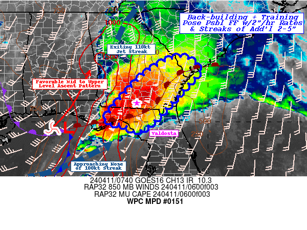
MESOSCALE PRECIPITATION DISCUSSION 0151
NWS WEATHER PREDICTION CENTER COLLEGE PARK MD
535 AM EDT FRI MAY 29 2015
AREAS AFFECTED...EASTERN TEXAS...SOUTHEAST OK
CONCERNING...HEAVY RAINFALL...FLASH FLOODING POSSIBLE
VALID 290935Z - 291530Z
SUMMARY...ADDITIONAL MODERATE TO HEAVY RAIN IS EXPECTED OVER
ALREADY SATURATED GROUND IN PARTS OF EAST TX THROUGH MID MORNING.
DISCUSSION...A LINE WAS MOVING STEADILY EASTWARD OVER PARTS OF
CENTRAL AND EAST TEXAS EARLY THIS MORNING. THE LINE WILL BE
MOVING INTO AN AREA WHERE MLCAPES WERE ON THE ORDER OF 2500 TO
3500 J/KG AND THERE IS A STEADY FEED OF DEEP LAYERED MOISTURE FROM
THE GULF.
ONE REGION OF CONCERN WILL BE IN REGIONS WHERE THE SOUTHEAST LOW
LEVEL FLOW INTERSECTS THE APPROACHING LINE OF CONVECTION. RADAR
SHOWED THAT THIS PROCESS WAS ALREADY UNDERWAY OVER PARTS OF
SOUTHEAST TX...AND THIS AREA COULD EASILY SEE SEVERAL INCHES OF
RAIN PER HOUR.
SEVERAL OF THE HI RESOLUTION MODELS DEPICTED A SECOND AREA OF
MODERATE TO HEAVY RAINFALL POSSIBLY DEVELOPING LATER THIS MORNING
OVER NORTHEAST TX INTO SOUTHEAST OK AHEAD OF A CONVECTIVE VORT
MAX. WHILE THE HI RES MODELS WERE STRUGGLING WITH PLACEMENT AND
AMOUNTS...THE 00Z WRF/ARW APPEARED TO DO THE BEST AT CAPTURING
DEVELOPMENT AND TRACK OF THE MCV.
THESE STORMS SHOULD BE CAPABLE OF PRODUCING 1 TO 2 INCHES OF RAIN
PER HOUR WITH LOCALIZED AMOUNTS IN EXCESS OF 3 HOURS BEFORE THE
RAINFALL RATES TAPER OFF.
BANN
ATTN...WFO...FWD...HGX...LCH...OUN...SHV...TSA...
ATTN...RFC...ABRFC...LMRFC...WGRFC...
LAT...LON 35329466 33369474 30959414 30199452 28849563
29289633 30929607 33119707 34619657
issued after earlier SPENES http://www.ospo.noaa.gov/data/atmospher ... 90901.html
-
Katdaddy

- Global Moderator

- Posts: 2504
- Joined: Thu Feb 04, 2010 8:18 am
- Location: League City, Tx
- Contact:
A Flash Flood Watch is in effect for Central portions of SE TX including Houston until noon as a line of weakening thunderstorm moves across the area this morning which could lead to some heavy rains and flash flooding Additional heavy rains will be possible Saturday with a weak cool front. The Dallas-Ft Worth areas have seen the flooding early this morning with a Flash Flood Emergency for areas just NE of Dallas.
- Attachments
-
- Screen Shot 2015-05-29 at 5.22.29 AM.png (23.05 KiB) Viewed 5120 times
-
- Screen Shot 2015-05-29 at 5.25.07 AM.png (196.59 KiB) Viewed 5120 times
The cell that just passed through Cypress meant business. 0.70" of rain in just 10 minutes.
-
srainhoutx

- Site Admin

- Posts: 19620
- Joined: Tue Feb 02, 2010 2:32 pm
- Location: Maggie Valley, NC
- Contact:
Morning update from Jeff:
Large thunderstorm complex which developed over NW TX overnight has moved into SE TX this morning in a weakened state. Radar trends continue to suggest an overall weakening trend with this line of thunderstorms as the complex weakens. With that said the forward movement of the line is starting to slow due to the weakening of the storms and this could resulting in a decrease of the forward speed of the storms.
Rainfall rates with this line have averaged 1-3 inches across much of central and north TX and recently 1-2 inches over Washington County. Generally expecting rainfall amounts of less than .50 of an inch across Harris County with isolated amounts upwards of 1.0 inch as long as storm continue to move and do not slow any more or train over the area.
Short term models are at odds over what to do this afternoon with respect to additional storm chances. Outflow boundary certainly looks to make it toward the coast and possibly offshore which would help stabilize the atmosphere resulting in lower rain chances this afternoon…this seems most likely at the moment. Other option is the boundary stalls further inland with redevelopment along that boundary with surface heating this morning.
Saturday and Saturday night look wet with a weak frontal boundary moving into the area from the north. Thunderstorms are expected to focus along this boundary on Saturday and Saturday night with heavy rainfall possible. Additional rainfall amounts on Saturday of 1-3 inches with isolated totals of 4-5 inches will be possible.
Carla/Alicia/Jerry(In The Eye)/Michelle/Charley/Ivan/Dennis/Katrina/Rita/Wilma/Humberto/Ike/Harvey
Member: National Weather Association
Facebook.com/Weather Infinity
Twitter @WeatherInfinity
Member: National Weather Association
Facebook.com/Weather Infinity
Twitter @WeatherInfinity
-
tireman4

- Global Moderator
- Posts: 4521
- Joined: Wed Feb 03, 2010 9:24 pm
- Location: Humble, Texas
- Contact:
HGX AFD from earlier this morning..
000
FXUS64 KHGX 291218
AFDHGX
AREA FORECAST DISCUSSION
NATIONAL WEATHER SERVICE HOUSTON/GALVESTON TX
718 AM CDT FRI MAY 29 2015
.UPDATE...
CANCELED PART OF THE FLASH FLOOD WATCH AND ADJUSTED POPS FOR THE
MORNING.
&&
.DISCUSSION...
WILL CANCEL WESTERN PARTS OF THE FLASH FLOOD WATCH AND ADJUST POPS
LOWER OVER THE WEST FOR THIS MORNING. NEW ZONES OUT SHORTLY. 43
&&
.PREV DISCUSSION... /ISSUED 639 AM CDT FRI MAY 29 2015/
DISCUSSION...
SEE THE 12Z AVIATION DISCUSSION BELOW.
40
AVIATION...
THE LEADING EDGE OF THE DIMINISHING SQUALL LINE WAS LOCATED FROM
KUTS TO THE HOUSTON METRO SITES TO KLBX AT 1130Z. EXPECT THESE TO
CLEAR THROUGH THE SITES BETWEEN 12Z AND 1230Z...AND THEN KGLS BY
13Z. RAIN OCCURRING IN THE TRAILING COLD POOL SHOULD LAST THROUGH
MID MORNING AT THE LATEST. THE RAP13 MODEL DID A DECENT JOB WITH
THE SYSTEM. THE MODEL KEEPS THE POTENTIAL FOR TSRA AT KGLS AND
KLBX THROUGH MIDDAY AND THE POTENTIAL FOR REDEVELOPMENT LATER
THIS AFTERNOON OVER THE OTHER INLAND SITES. VFR EXPECTED TONIGHT
BUT THERE IS AN OUTSIDE CHANCE FOR MVFR CONDITIONS TO DEVELOP.
NEXT BEST CHANCES FOR RAIN AND THUNDERSTORMS WILL BE SATURDAY
AFTERNOON AS A FRONTAL BOUNDARY SINKS SOUTHWARD OF THE RED RIVER
VALLEY.
-
srainhoutx
- Site Admin
- Posts: 19620
- Joined: Tue Feb 02, 2010 2:32 pm
- Location: Maggie Valley, NC
- Contact:
The early 12Z computer guidance is suggesting 1-3 inches with isolated higher totals across portions of SE Texas with the stalling frontal boundary Saturday into Saturday night. The NAM is a bit more aggressive than the GFS, but enough of a concern that we may see Flash Flood Watches hoisted this afternoon. Stay Weather Aware again tomorrow folks.
- Attachments
-
Carla/Alicia/Jerry(In The Eye)/Michelle/Charley/Ivan/Dennis/Katrina/Rita/Wilma/Humberto/Ike/Harvey
Member: National Weather Association
Facebook.com/Weather Infinity
Twitter @WeatherInfinity
Member: National Weather Association
Facebook.com/Weather Infinity
Twitter @WeatherInfinity
-
srainhoutx
- Site Admin
- Posts: 19620
- Joined: Tue Feb 02, 2010 2:32 pm
- Location: Maggie Valley, NC
- Contact:
A very large geographical area of Texas including SE Texas are again under Flash Flood Watches.
FLOOD WATCH
NATIONAL WEATHER SERVICE HOUSTON/GALVESTON TX
333 PM CDT FRI MAY 29 2015
AUSTIN-BRAZORIA-BRAZOS-BURLESON-CHAMBERS-COLORADO-FORT BEND-
GALVESTON-GRIMES-HARRIS-HOUSTON-JACKSON-LIBERTY-MADISON-MATAGORDA-
MONTGOMERY-POLK-SAN JACINTO-TRINITY-WALKER-WALLER-WASHINGTON-
WHARTON-
INCLUDING THE CITIES OF...ALVIN...ANAHUAC...ANGLETON...BAY CITY...
BELLVILLE...BRENHAM...BROOKSHIRE...BRYAN...CALDWELL...CLEVELAND...
COLDSPRING...COLLEGE STATION...COLUMBUS...CONROE...CORRIGAN...
CROCKETT...DAYTON...EAGLE LAKE...EDNA...EL CAMPO...FREEPORT...
FRIENDSWOOD...GALVESTON...GROVETON...HEMPSTEAD...HOUSTON...
HUMBLE...HUNTSVILLE...KATY...LAKE JACKSON...LAKE SOMERVILLE...
LEAGUE CITY...LIBERTY...LIVINGSTON...MADISONVILLE...
MISSOURI CITY...MONT BELVIEU...NAVASOTA...ONALASKA...PALACIOS...
PASADENA...PEARLAND...PIERCE...PRAIRIE VIEW...RICHMOND...
ROSENBERG...SEALY...SHEPHERD...SUGAR LAND...TEXAS CITY...
THE WOODLANDS...TOMBALL...TRINITY...WEIMAR...WHARTON...WILLIS...
WINNIE
333 PM CDT FRI MAY 29 2015
...FLASH FLOOD WATCH IN EFFECT FROM SATURDAY AFTERNOON THROUGH
SUNDAY MORNING...
THE NATIONAL WEATHER SERVICE IN HOUSTON/GALVESTON HAS ISSUED A
* FLASH FLOOD WATCH FOR A PORTION OF SOUTHEAST TEXAS...INCLUDING
THE FOLLOWING COUNTIES...AUSTIN...BRAZORIA...BRAZOS...
BURLESON...CHAMBERS...COLORADO...FORT BEND...GALVESTON...
GRIMES...HARRIS...HOUSTON...JACKSON...LIBERTY...MADISON...
MATAGORDA...MONTGOMERY...POLK...SAN JACINTO...TRINITY...
WALKER...WALLER...WASHINGTON AND WHARTON.
* FROM SATURDAY AFTERNOON THROUGH SUNDAY MORNING
* A SLOW MOVING FRONT WILL PUSH INTO SOUTHEAST TEXAS SATURDAY
AFTERNOON THROUGH SUNDAY MORNING. THUNDERSTORMS ARE EXPECTED TO
DEVELOP ALONG IT AND ALSO AHEAD OF THE FRONT DURING THE
AFTERNOON. STORMS WILL BE SLOW MOVING AND CAPABLE OF PRODUCING 1
TO 2 INCHES AN HOUR. GENERAL RAINFALL AMOUNTS OF 1 TO 3 INCHES
WILL BE POSSIBLE BUT THERE MAY BE ISOLATED AREAS OF 5 TO 7
INCHES. ANY RAINFALL AMOUNTS OVER 3 INCHES WILL CAUSE FLOODING
PROBLEMS.
* GROUNDS ARE ALREADY SATURATED SO ANY ADDITIONAL RAINFALL WILL
LIKELY RUN OFF INTO BAYOUS...CREEKS...RIVERS AND LAKES. TYPICAL
LOW LYING AREAS SUCH AS UNDERPASSES COULD FLOOD QUICKLY WITH
RAINFALL RATES OF 1 TO 2 INCHES AN HOUR. ADDITIONAL RAINFALL
COULD PROLONG RIVER FLOODING ACROSS THE AREA. HEAVY RAINFALL
COULD OCCUR OVERNIGHT SATURDAY WHICH WILL INCREASE THE HAZARDS
OF FLOODING. IF FLASH FLOOD WARNINGS ARE ISSUED IN YOUR
AREA...DO NOT DRIVE INTO FLOODED ROADS OR UNDERPASSES. TURN
AROUND DO NOT DROWN.
Carla/Alicia/Jerry(In The Eye)/Michelle/Charley/Ivan/Dennis/Katrina/Rita/Wilma/Humberto/Ike/Harvey
Member: National Weather Association
Facebook.com/Weather Infinity
Twitter @WeatherInfinity
Member: National Weather Association
Facebook.com/Weather Infinity
Twitter @WeatherInfinity
-
srainhoutx
- Site Admin
- Posts: 19620
- Joined: Tue Feb 02, 2010 2:32 pm
- Location: Maggie Valley, NC
- Contact:
Afternoon briefing from Jeff:
Flash Flood Watch will be in effect from noon Saturday until 700am Sunday.
Factors coming together to produce another round of potentially heavy rainfall across the area late Saturday into early Sunday. A slow moving cool front will combine with deep tropical moisture to produce numerous showers and thunderstorms. Expect storms to develop along and ahead of the cool front Saturday afternoon and continue into Saturday night and Sunday morning. A bit concerned with a couple of the models showing a weak convergent boundary over SE TX Saturday evening which could help focus organized development ahead of the front.
Storm motions will be on the slower side and with high moisture levels high short term rainfall rates are likely.
Widespread rainfall amounts of 1-3 inches look likely with isolated totals of 5-7 inches. Rainfall of this magnitude will cause additional flooding especially the upper end of the 1-3 inches and certainly the isolated 5-7. General thinking is the Harris County watersheds can handle the 1-2 inches without many problems.
HCFCD Flood Watch staff will remain in stand by mode until Monday morning at 700am in support of HCOEM Level 3 activation, expected additional rainfall, and ongoing flooding on the San Jacinto River.
Carla/Alicia/Jerry(In The Eye)/Michelle/Charley/Ivan/Dennis/Katrina/Rita/Wilma/Humberto/Ike/Harvey
Member: National Weather Association
Facebook.com/Weather Infinity
Twitter @WeatherInfinity
Member: National Weather Association
Facebook.com/Weather Infinity
Twitter @WeatherInfinity
-
Paul Robison
Will this help your concerns, Srainhoutex?srainhoutx wrote:Afternoon briefing from Jeff:
Flash Flood Watch will be in effect from noon Saturday until 700am Sunday.
Factors coming together to produce another round of potentially heavy rainfall across the area late Saturday into early Sunday. A slow moving cool front will combine with deep tropical moisture to produce numerous showers and thunderstorms. Expect storms to develop along and ahead of the cool front Saturday afternoon and continue into Saturday night and Sunday morning. A bit concerned with a couple of the models showing a weak convergent boundary over SE TX Saturday evening which could help focus organized development ahead of the front.
Storm motions will be on the slower side and with high moisture levels high short term rainfall rates are likely.
Widespread rainfall amounts of 1-3 inches look likely with isolated totals of 5-7 inches. Rainfall of this magnitude will cause additional flooding especially the upper end of the 1-3 inches and certainly the isolated 5-7. General thinking is the Harris County watersheds can handle the 1-2 inches without many problems.
HCFCD Flood Watch staff will remain in stand by mode until Monday morning at 700am in support of HCOEM Level 3 activation, expected additional rainfall, and ongoing flooding on the San Jacinto River.
NOAA says:
000
FXUS64 KHGX 292100
AFDHGX
AREA FORECAST DISCUSSION
NATIONAL WEATHER SERVICE HOUSTON/GALVESTON TX
400 PM CDT FRI MAY 29 2015
...FLASH FLOOD WATCH SATURDAY AFTERNOON INTO SUNDAY MORNING...
.DISCUSSION...
THE SQUALL LINE OF STORMS THAT PUSHED THROUGH THIS MORNING
DROPPED ENOUGH RAIN TO AT LEAST MAKE SURE GROUNDS ARE SATURATED
GOING INTO THE WEEKEND. WATER VAPOR IMAGERY SHOWS UPPER LOW OVER
THE ARKLATEX MOVING EAST WITH ITS TROUGH AXIS MOVING ACROSS SE TX.
A SECOND UPPER LEVEL LOW OVER W NEBRASKA SHOULD CONTINUE TO DROP
SOUTH THROUGH THE PLAINS TONIGHT INTO SATURDAY. THIS SECOND TROUGH
SPLITS WITH ONE VORTICITY LOBE PUSHING EAST AND A SECOND VORTICITY
LOBE DROPPING INTO THE S PLAINS. A COLD FRONT ASSOCIATED WITH THIS
SYSTEM SHOULD MOVE INTO TEXAS SATURDAY REACHING SE TX IN THE
AFTERNOON. FRONT SHOULD SLOWLY PUSH THROUGH THE AREA OVERNIGHT
INTO SUNDAY. DEEP MOISTURE SHOULD DEVELOP OVER THE AREA WITH
PRECIP WATER VALUES REACHING 1.8-1.9 INCHES SATURDAY AFTERNOON.
OVERALL THE PATTERN IS SUPPORTIVE OF HEAVY RAINFALL. THERE WILL BE
DIFFLUENCE ALOFT WITH THE DEEP MOISTURE IN PLACE. FRONTAL BOUNDARY
WILL PROVIDE A FOCUS FOR THUNDERSTORM DEVELOPMENT. THE ONLY ISSUE
WILL BE THE LACK OF A STRONG LLJ OFF THE GULF TO FEED MOISTURE
INTO THE STORMS. UPPER LEVEL WINDS WILL BE WEAK SO STORM MOTIONS
WILL BE QUITE SLOW. IT IS QUITE POSSIBLE FOR STORMS TO PRODUCE 1-2
INCHES OF RAINFALL IN AN HOUR. ANY RAINFALL AMOUNTS OVER 3 INCHES
WILL CAUSE FLOODING PROBLEMS. A FLASH FLOOD WATCH HAS BEEN ISSUED
FOR THESE REASONS.
Surely, Srainhoutex, what I've placed in bold might be something of a saving grace for us, yes? It should be pointed out that what caused our problem last weekend was the GULF LLJ that fed moisture into the storms. I'm more worried about the marginal (5%) risk SPC has us under for severe. We don't need the wind blowing any more trees down, obviously.
BTW: You're a little vague on what you're concerned about. Bottom line it for me, if you respond.
-
Katdaddy
- Global Moderator
- Posts: 2504
- Joined: Thu Feb 04, 2010 8:18 am
- Location: League City, Tx
- Contact:
Good evening Paul. The main concern is the potential of heavy rains on already saturated grounds this weekend. As you stated the severe weather threat is marginal per the SPC. Theme for the weekend…….."Be Weather Aware" especially in flood prime areas and near creeks, streams, and rivers that are already full or above flood stage.
-
Paul Robison
This met's worried about more than heavy rains, and so am I. Read:Katdaddy wrote:Good evening Paul. The main concern is the potential of heavy rains on already saturated grounds this weekend. As you stated the severe weather threat is marginal per the SPC. Theme for the weekend…….."Be Weather Aware" especially in flood prime areas and near creeks, streams, and rivers that are already full or above flood stage.
ANOTHER THING TO KEEP AN EYE ON DURING THE AFTERNOON & EVNG HOURS IS A SEABREEZE (OR SCT CELLS ASSOCIATED WITH) COLLIDING WITH THIS WEAK FRONTAL BOUNDARY & FURTHER ENHANCING STORM STRENGTH & RAIN RATES. ALTHOUGH NOT SEEING MUCH IN MODEL GUIDANCE SHOWING THIS - IT`S HAPPENED MORE TIMES THAN I CARE TO REMEMBER W/ SIMILAR TYPE PATTERNS IN THE PAST... 47
Is he just being cautious, or does he really expect it to happen? Curious.
-
srainhoutx
- Site Admin
- Posts: 19620
- Joined: Tue Feb 02, 2010 2:32 pm
- Location: Maggie Valley, NC
- Contact:
The main concern is not severe storms. The dynamics do not support a big severe weather episode. What is concerning is saturated soils and rivers and streams already swollen after a month of heavy rainfall. Paul, you have a tendency to over dramatize every little thing that the Professional Meteorologist even mention as a concern. Weather forecasting is not and likely will never be an absolute science. Are there concerns about potentially heavy training rainfall along a frontal boundary? That answer is yes. Is the whole State or area going to flood? Probably not. Let's try to not over analyze every little thing. And also you can chill with those super secret PM's of doom and gloom. I and others offer opinions for discussion and our Pro Mets like Jeff and the forecasters from the various NWS offices are doing their absolute best to offer a forecast that informs the public of the potentials so folks that are dealing with river flooding know what they might expect. At least 7 people lost their lives in Metro Houston this week from weather related issues. Over 20 State wide have died. The very first Flash Flood Emergency was issued for the Houston/Galveston area this week. let's dial back the confrontational posts and watch the radar trends tomorrow. If weather worries materialize, we will be here to get the word out with reliable and factual information very quickly. Have a great evening... 
Carla/Alicia/Jerry(In The Eye)/Michelle/Charley/Ivan/Dennis/Katrina/Rita/Wilma/Humberto/Ike/Harvey
Member: National Weather Association
Facebook.com/Weather Infinity
Twitter @WeatherInfinity
Member: National Weather Association
Facebook.com/Weather Infinity
Twitter @WeatherInfinity
-
Paul Robison
srainhoutx wrote:The main concern is not severe storms. The dynamics do not support a big severe weather episode. What is concerning is saturated soils and rivers and streams already swollen after a month of heavy rainfall. Paul, you have a tendency to over dramatize every little thing that the Professional Meteorologist even mention as a concern. Weather forecasting is not and likely will never be an absolute science. Are there concerns about potentially heavy training rainfall along a frontal boundary? That answer is yes. Is the whole State or area going to flood? Probably not. Let's try to not over analyze every little thing. And also you can chill with those super secret PM's of doom and gloom. I and others offer opinions for discussion and our Pro Mets like Jeff and the forecasters from the various NWS offices are doing their absolute best to offer a forecast that informs the public of the potentials so folks that are dealing with river flooding know what they might expect. At least 7 people lost their lives in Metro Houston this week from weather related issues. Over 20 State wide have died. The very first Flash Flood Emergency was issued for the Houston/Galveston area this week. let's dial back the confrontational posts and watch the radar trends tomorrow. If weather worries materialize, we will be here to get the word out with reliable and factual information very quickly. Have a great evening...
Well, I only mentioned that because the pro met that said that is one of my neighbors, and he talked about it with me first. Anyway, here's the latest HGX:
000
FXUS64 KHGX 300158
AFDHGX
AREA FORECAST DISCUSSION
NATIONAL WEATHER SERVICE HOUSTON/GALVESTON TX
858 PM CDT FRI MAY 29 2015
.DISCUSSION...
QUIET EVENING ACROSS SE TX WITH MOSTLY CLEAR SKIES. ADJUSTED POPS
DOWN FOR THE REST OF THE EVENING AND TAPERED FROM CHC POPS ACROSS
THE EXTREME NORTHERN AREAS TO SLIGHT CHC ELSEWHERE FOR THE EARLY
MORNING HOURS. EXPECT CPNVECTIVE ACTIVITY TO INCREASE LATE
MORNING/EARLY AFTERNOON TOMORROW AS A SLOW MOVING FRONT APPROACHES
FROM THE NW. STILL SOME MODEL DIFFERENCES CONCERNING TIMING OF
THE PRECIP TOMORROW. ONLY CHG FOR NOW IS TO ADJUST POPS DOWN A
LITTLE IN THE MORNING ACROSS SE AREAS. STILL EXPECT A HEAVY
RAINFALL/FLOOD THREAT NEAR THE BOUNDARY BEGINNING AT SOME POINT
IN THE AFTERNOON AND CONTINUING INTO SAT NIGHT. 33
He's a good man, believe me.
-
GBinGrimes

- Posts: 108
- Joined: Mon Jan 27, 2014 1:50 pm
- Location: Anderson, TX
- Contact:
Srain....you spoke diplomatically and with much kindness and reserve. Quite a gentleman and I appreciate how you spoke to Paul's tendencies to over dramatize the forecasting.
That said...I'll just get to my point to Paul.
Paul, the pros here are giving of their time and expertise. We value that and it is free. Your posts and questions to them are blatantly rude and often condescending. You need to stop.
We all love to comment and share what we see or think, but do not call to question what is freely given by kind and caring people whom we all care about and greatly respect.
Now that being said...I LOVED seeing sunshine and feeling the heat of the sun today!
from the QPF discussion: http://www.wpc.ncep.noaa.gov/discussion ... isc=qpfpfd
...tx into the lower ms valley...
the unsettled and rainy pattern will persist thru this period for much of tx except the panhandle.. but with expected rainfall amounts not as heavy as we've seen recently. a slight drying trend.. at least moisture and pw-wise.. was noted over much of tx this evening behind the mcv and its trailing shear axis down into the lower ms valley. this slight drying trend.. along with the development of a northwesterly mid/upper level flow regime which should allow for a more progressive convective pattern.. should hopefully translate into those lighter rainfall amounts. that said.. convection is still going to be rather organized and will impact much of tx this period.. triggered by s/wv energy dropping southeastward out of the southern rockies thru the state. some east-west convection which may hang up briefly late friday night and saturday morning thru northern tx may produce some locally heavier rainfall amounts before the frontal passage saturday afternoon lessens the locally heavy rainfall potential. from later saturday afternoon into saturday night.. any heavier rainfall threat is likely to shift into southeastern tx.. where the higher pws will persist until the frontal passage later saturday night. kept areal average rainfall amounts generally in the 0.50-1.00 inch range.. but some locally heavier totals certainly possible.
interesting, from the extended forecast discussion: http://www.wpc.ncep.noaa.gov/discussion ... isc=pmdepd
meanwhile the fcst has become increasingly uncertain and complicated across the srn tier. through the 18z cycle... gfs/gefs-based solns had been persistent in closing off an upr low near the lwr ms vly while ecmwf/ecmwf mean runs as well as cmc/cmc mean solns were trending more open and progressive with the energy over the past day. gfs/gefs persistence and slow moving nature of srn tier flow aloft offered some allowance for the gfs scenario. however the 00z gfs/gefs mean have trended more progressive thus lowering the potential for a wwd soln.
then there is the further complication of how this feature may interact with one or more impulses that may flow nnewd from the wrn caribbean or vicinity... and what kind of sfc evolution will result. for now prefer a conservative approach with a broad sfc trough as it remains to be seen whether mid lvl energy will evolve in such a way as to support a well defined sfc system. also note that 12z gefs/ecmwf ensemble probs of combined high rh/low wind shear are fairly low from the sern gulf newd.
and from the excessive rainfall discussion:
..parts of tx...
the unsettled and rainy pattern will persist thru this period for much of tx except the panhandle..but with expected rainfall amounts not as heavy as we've seen recently. a slight drying trend..at least moisture and pw-wise..was noted over much of tx this evening behind the ar mcv and its trailing shear axis down into the lower ms valley. this slight drying trend..along with the development of a northwesterly mid/upper level flow regime which should allow for a more progressive convective pattern..should hopefully translate into those lighter rainfall amounts..especially as we get farther into the day 1 period. that said..convection is still going to be rather organized and will impact much of tx this period..triggered by s/wv energy dropping southeastward out of the southern rockies thru the state. some east-west convection which may hang up briefly into the saturday morning hours thru northern tx ahead of the developing mcv back over western tx at this time..and will likely produce some locally heavier rainfall amounts before the frontal passage saturday afternoon lessens the locally heavy rainfall potential here. kept a small slight risk thru northern tx associated with this mcv..given the saturated conditions in place. from later saturday afternoon into saturday night..any heavier rainfall threat is likely to shift into southeastern tx..where the higher pws will persist until the frontal passage later saturday night. kept areal average rainfall amounts here generally in the 0.50-1.00 inch range..but some locally heavier totals certainly possible.
we are now, officially, a disaster area, again:
http://www.khou.com/story/news/local/te ... /28194937/
https://www.fema.gov/disasters/grid/sta ... _tid_1=All
Texas leads the nation in the number of both Major Disaster Declarations and Fire Management Assistance Declarations: https://www.fema.gov/disasters/grid/sta ... government
http://www.khou.com/story/news/local/te ... /28194937/
https://www.fema.gov/disasters/grid/sta ... _tid_1=All
Texas leads the nation in the number of both Major Disaster Declarations and Fire Management Assistance Declarations: https://www.fema.gov/disasters/grid/sta ... government