

2015 Eastern Pacific Tropical Weather Discussion
-
srainhoutx

- Site Admin

- Posts: 19616
- Joined: Tue Feb 02, 2010 2:32 pm
- Location: Maggie Valley, NC
- Contact:
Hurricane Andres has likely peaked in its intensity and should begin to weaken throughout the coming week as it moves generally West away from Mexico. Eyes turn to 93E which is much closer to the Pacific Coast of Mexico and is expected to develop into a Tropical Cyclone later this week. There are some worrisome trends via the Global operational and ensemble guidance suggesting a deepening Western trough begins to organize later this coming work week into next weekend and could influence the eventual path of 93E and pull it and its moisture across Mexico and possibly Texas late next weekend into the second week of June.
Carla/Alicia/Jerry(In The Eye)/Michelle/Charley/Ivan/Dennis/Katrina/Rita/Wilma/Humberto/Ike/Harvey
Member: National Weather Association
Facebook.com/Weather Infinity
Twitter @WeatherInfinity
Member: National Weather Association
Facebook.com/Weather Infinity
Twitter @WeatherInfinity
-
srainhoutx
- Site Admin
- Posts: 19616
- Joined: Tue Feb 02, 2010 2:32 pm
- Location: Maggie Valley, NC
- Contact:
Tropical Depression 2E has formed off the Pacific Coast of Mexico:
TROPICAL DEPRESSION TWO-E SPECIAL DISCUSSION NUMBER 1
NWS NATIONAL HURRICANE CENTER MIAMI FL EP022015
530 PM CDT SUN MAY 31 2015
Visible satellite images this afternoon indicate that deep
convection has developed over the center of the well-defined low
pressure system to the south of Zihuatanejo, Mexico. Therefore the
system qualifies as a tropical cyclone, and advisories are being
initiated at this time.
The initial motion estimate is 300/05. The depression is located
in a region of weak steering but with enough ridging in the short
term for the cyclone to drift generally west-northwestward to
northwestward through Monday. In 36-48 hours, a mid-level
ridge located west of the cyclone could impart an unusual southward
motion for a day or so. After that time, global models show
stronger ridging developing over northern Mexico and the
south-central United States, which should result in a faster
west-northwestward or northwestward motion. The official NHC track
forecast is close to the multi-model consensus (TVCE) throughout the
forecast period.
Strong northwesterly vertical wind shear associated with the
outflow of Hurricane Andres should preclude significant
intensification during the next day or two. After that time, the
shear is expected to become northeasterly and decrease
substantially, while the cyclone moves slowly in a moist
environment and over very warm waters of around 30 deg C. These
factors should lead to a faster rate intensification, perhaps
greater than what is currently forecast. The NHC intensity
forecast is closest to the SHIPS and HWRF models, which show the
most strengthening of the intensity guidance.
FORECAST POSITIONS AND MAX WINDS
INIT 31/2230Z 12.4N 103.0W 30 KT 35 MPH
12H 01/0600Z 13.1N 103.8W 30 KT 35 MPH
24H 01/1800Z 13.7N 104.5W 30 KT 35 MPH
36H 02/0600Z 13.8N 104.8W 35 KT 40 MPH
48H 02/1800Z 13.3N 104.8W 45 KT 50 MPH
72H 03/1800Z 12.3N 104.4W 60 KT 70 MPH
96H 04/1800Z 12.7N 105.1W 75 KT 85 MPH
120H 05/1800Z 15.0N 107.4W 90 KT 105 MPH
$$
Forecaster Kimberlain/Pasch
- Attachments
-
Carla/Alicia/Jerry(In The Eye)/Michelle/Charley/Ivan/Dennis/Katrina/Rita/Wilma/Humberto/Ike/Harvey
Member: National Weather Association
Facebook.com/Weather Infinity
Twitter @WeatherInfinity
Member: National Weather Association
Facebook.com/Weather Infinity
Twitter @WeatherInfinity
-
srainhoutx
- Site Admin
- Posts: 19616
- Joined: Tue Feb 02, 2010 2:32 pm
- Location: Maggie Valley, NC
- Contact:
TD 2E continues to fester offshore of Mexico and could become Tropical Storm Blanca later today.
TROPICAL DEPRESSION TWO-E DISCUSSION NUMBER 3
NWS NATIONAL HURRICANE CENTER MIAMI FL EP022015
400 AM CDT MON JUN 01 2015
The tropical depression is producing a large area of deep convection
with very cold cloud tops, however, the convection does not appear
to have become significantly better organized overnight. Satellite
intensity estimates are T2.0 on the Dvorak scale and the initial
intensity is held at 30 kt. The strong northwesterly shear that is
currently affecting the tropical cyclone is forecast to decrease
significantly during the next 12 to 24 hours. This should allow
the depression to strengthen into a tropical storm later today.
By Tuesday, the cyclone is expected to be within a low shear
environment and over very warm waters. These conditions favor a
faster rate of intensification and the NHC forecast follows the
SHIPS guidance, which calls for the cyclone to become a hurricane
in about 48 hours, and obtain major hurricane status in 3 to 4
days. The intensity forecast is also supported by the global
model guidance, which significantly deepen the cyclone in 2 to 3
days.
The center has been extremely difficult to locate overnight,
so the initial motion of 305/5 is much more uncertain than normal.
Overall, little motion is forecast during the next few days
while the cyclone remains in an area of weak steering flow. After
72 hours, a mid-level ridge is forecast to strengthen over northern
Mexico. This should cause the cyclone to begin moving northwestward
at a faster forward speed. The NHC forecast is close to the
multi-model consensus and the GFS ensemble mean.
FORECAST POSITIONS AND MAX WINDS
INIT 01/0900Z 13.3N 104.0W 30 KT 35 MPH
12H 01/1800Z 13.7N 104.6W 40 KT 45 MPH
24H 02/0600Z 13.7N 104.9W 45 KT 50 MPH
36H 02/1800Z 13.6N 105.1W 55 KT 65 MPH
48H 03/0600Z 13.4N 105.3W 65 KT 75 MPH
72H 04/0600Z 13.1N 105.6W 90 KT 105 MPH
96H 05/0600Z 14.5N 106.9W 105 KT 120 MPH
120H 06/0600Z 17.5N 109.5W 105 KT 120 MPH
$$
Forecaster Brown
- Attachments
-
-
Carla/Alicia/Jerry(In The Eye)/Michelle/Charley/Ivan/Dennis/Katrina/Rita/Wilma/Humberto/Ike/Harvey
Member: National Weather Association
Facebook.com/Weather Infinity
Twitter @WeatherInfinity
Member: National Weather Association
Facebook.com/Weather Infinity
Twitter @WeatherInfinity
-
srainhoutx
- Site Admin
- Posts: 19616
- Joined: Tue Feb 02, 2010 2:32 pm
- Location: Maggie Valley, NC
- Contact:
Tropical Storm Blanca forms off the Pacific Coast of Mexico. It is expected to achieve Major Hurricane Status.
TROPICAL STORM BLANCA DISCUSSION NUMBER 4
NWS NATIONAL HURRICANE CENTER MIAMI FL EP022015
1000 AM CDT MON JUN 01 2015
The convective pattern of the cyclone features a developing central
dense overcast and an expansive convective band to the east and
southeast of the center. Based on the latest Dvorak classification
of T2.5/35 kt from TAFB, the cyclone is upgraded to Tropical Storm
Blanca on this advisory. The SHIPS model and satellite analysis
from UW-CIMSS show about 20 kt of shear currently affecting Blanca.
However, the models show the shear quickly relaxing during the next
12 to 24 hours, which should allow Blanca to take advantage of an
otherwise favorable environment. As a result, steady if not rapid
intensification is expected to begin soon. In fact, the SHIPS RI
index shows a 74 percent chance of a 30-kt increase in the next 24
hours. The official forecast follows this trend and shows a quicker
rate of intensification than the previous one through 48 hours.
Additional strengthening is expected later in the forecast period.
The new NHC forecast is close to the more aggressive SHIPS model and
is well above the IVCN intensity consensus.
Microwave imagery from AMSR2 on GCOM-W1 at 0743Z and from the GPM
satellite at 1031Z were helpful in establishing the initial
position, which is just a little to the right of the previous
advisory. The track forecast philosophy remains unchanged. A slow
northwestward or west-northwestward motion is expected today,
followed by a slow erratic motion through 72 hours as the steering
flow weakens. Late in the period, a ridge will amplify over
northern Mexico which should result in a steadier motion toward the
northwest at days 4 and 5. The new NHC track is a little to the
right of the previous one after an adjustment toward the latest TVCE
multi-model consensus.
Blanca is expected to remain well offshore of the southwestern coast
of Mexico through the forecast period. However, some rainbands on
the outer periphery of the circulation could affect portions of the
coast during the next couple of days.
FORECAST POSITIONS AND MAX WINDS
INIT 01/1500Z 13.5N 104.1W 35 KT 40 MPH
12H 02/0000Z 13.8N 104.6W 45 KT 50 MPH
24H 02/1200Z 13.8N 104.9W 65 KT 75 MPH
36H 03/0000Z 13.6N 105.1W 75 KT 85 MPH
48H 03/1200Z 13.4N 105.3W 85 KT 100 MPH
72H 04/1200Z 13.4N 105.3W 100 KT 115 MPH
96H 05/1200Z 15.5N 107.3W 110 KT 125 MPH
120H 06/1200Z 18.5N 110.0W 100 KT 115 MPH
$$
Forecaster Brennan
- Attachments
-
Carla/Alicia/Jerry(In The Eye)/Michelle/Charley/Ivan/Dennis/Katrina/Rita/Wilma/Humberto/Ike/Harvey
Member: National Weather Association
Facebook.com/Weather Infinity
Twitter @WeatherInfinity
Member: National Weather Association
Facebook.com/Weather Infinity
Twitter @WeatherInfinity
-
srainhoutx
- Site Admin
- Posts: 19616
- Joined: Tue Feb 02, 2010 2:32 pm
- Location: Maggie Valley, NC
- Contact:
Blanca on its way to becoming a Hurricane and possibly a Major Hurricane with rapid intensification possible beginning tomorrow.
TROPICAL STORM BLANCA DISCUSSION NUMBER 5
NWS NATIONAL HURRICANE CENTER MIAMI FL EP022015
400 PM CDT MON JUN 01 2015
Blanca continues to gradually organize, and satellite imagery shows
a developing CDO and numerous banding features. The initial
intensity has been raised to 40 kt based on a recent ASCAT-B
pass and a blend of the latest Dvorak estimates from TAFB and SAB.
Steady if not rapid intensification is expected during the next
couple of days while the shear is forecast to decrease over the
cyclone. In fact the SHIPS RI index has the highest probabilities
that I've seen, including an almost 90 percent chance of a 40-kt
increase in 24 hours. However, the regional hurricane models
continue to be much less bullish. The NHC official forecast
continues to be closest to the SHIPS model and shows Blanca becoming
a hurricane on Tuesday and nearing major hurricane intensity in 48
hours. It is possible that the rate of intensification could be even
faster than indicated here. Some weakening is expected by day 5 as
the cyclone begins to encounter cooler waters accompanied by an
increase in shear.
Blanca may have drifted a bit eastward over the past few hours, but
the initial motion estimate is stationary. Little net motion is
forecast during the next 72 hours while the steering currents remain
weak. At days 4 and 5 a northwestward track is expected to begin as
a ridge builds to the northeast of Blanca over northern Mexico. The
latest NHC track forecast is similar to the previous one during the
first 72 hours and has been adjusted eastward at days 4-5 following
the trend of the latest multi-model consensus.
Blanca is expected to remain well offshore of the southwestern coast
of Mexico through the forecast period. However, some rainbands on
the outer periphery of the circulation could affect portions of the
coast during the next couple of days.
FORECAST POSITIONS AND MAX WINDS
INIT 01/2100Z 13.3N 103.9W 40 KT 45 MPH
12H 02/0600Z 13.4N 104.3W 55 KT 65 MPH
24H 02/1800Z 13.3N 104.5W 70 KT 80 MPH
36H 03/0600Z 13.1N 104.7W 85 KT 100 MPH
48H 03/1800Z 12.8N 104.8W 95 KT 110 MPH
72H 04/1800Z 13.2N 105.1W 110 KT 125 MPH
96H 05/1800Z 16.0N 107.5W 110 KT 125 MPH
120H 06/1800Z 19.0N 109.5W 90 KT 105 MPH
$$
Forecaster Brennan
- Attachments
-
Carla/Alicia/Jerry(In The Eye)/Michelle/Charley/Ivan/Dennis/Katrina/Rita/Wilma/Humberto/Ike/Harvey
Member: National Weather Association
Facebook.com/Weather Infinity
Twitter @WeatherInfinity
Member: National Weather Association
Facebook.com/Weather Infinity
Twitter @WeatherInfinity
-
srainhoutx
- Site Admin
- Posts: 19616
- Joined: Tue Feb 02, 2010 2:32 pm
- Location: Maggie Valley, NC
- Contact:
Intensity forecast continues to ramp up for Blanca.
TROPICAL STORM BLANCA DISCUSSION NUMBER 6
NWS NATIONAL HURRICANE CENTER MIAMI FL EP022015
1000 PM CDT MON JUN 01 2015
Blanca is gradually intensifying. Satellite imagery shows the
cyclone maintaining a small CDO dominated by very cold-topped deep
convection, with a vigorous primary band over the southeastern
portion of the circulation. Microwave satellite data, however,
indicate that Blanca's developing inner core currently lacks much
organization. Regardless, anticyclonic flow over Blanca is also
expanding and becoming better established, indicative of a
continued decrease in shear. A blend of Dvorak intensity estimates
is used to set the initial intensity to 45 kt.
Blanca has been meandering southward, but the overall motion is
essentially stationary. The cyclone should remain trapped in a
col area during the next 36 hours, but there should be just enough
northerly or north-northwesterly flow to nudge the center of Blanca
on a general southerly course. By 72 hours, the synoptic steering
over the eastern Pacific should change as an unusually deep longwave
trough settles into southern California and weak mid-level ridging
near Baja California shifts eastward and strengthens. This pattern
should cause Blanca to accelerate on a heading between northwest and
north-northwest beginning on Thursday. Only small adjustments were
made to the NHC track forecast during the first 36-48 hours, but
the track has been shifted to the right of the previous one between
72-120 hours, which is close to the multi-model consensus (TVCE).
Northwesterly shear affecting the cyclone is forecast to decrease
considerably within 24 hours and remain low for a couple of days
after that, while thermodynamic parameters in the near-storm
environment should be exceptionally conducive for rapid
intensification. An eastward-traveling upper-level shortwave trough
moving through Mexico in 48-72 hours could also enhance Blanca's
outflow, increasing the likelihood of a significant deepening during
this time. Late in the forecast period, east-southeasterly shear
and cooler waters should result in weakening, especially by day 5.
The NHC intensity forecast is increased above the previous one and
is closest to the FSU Superensemble and SHIPS model output, and well
above the weaker regional model solutions.
FORECAST POSITIONS AND MAX WINDS
INIT 02/0300Z 13.2N 104.0W 45 KT 50 MPH
12H 02/1200Z 13.0N 104.2W 55 KT 65 MPH
24H 03/0000Z 12.9N 104.4W 75 KT 85 MPH
36H 03/1200Z 12.7N 104.5W 90 KT 105 MPH
48H 04/0000Z 12.7N 104.3W 105 KT 120 MPH
72H 05/0000Z 14.5N 105.3W 120 KT 140 MPH
96H 06/0000Z 16.9N 107.7W 105 KT 120 MPH
120H 07/0000Z 20.1N 108.8W 85 KT 100 MPH
$$
Forecaster Kimberlain
- Attachments
-
Carla/Alicia/Jerry(In The Eye)/Michelle/Charley/Ivan/Dennis/Katrina/Rita/Wilma/Humberto/Ike/Harvey
Member: National Weather Association
Facebook.com/Weather Infinity
Twitter @WeatherInfinity
Member: National Weather Association
Facebook.com/Weather Infinity
Twitter @WeatherInfinity


I would not be surprised if Blanca is a Category 5 hurricane. It could have an impact on Texas weather with the forecasted path.
-
srainhoutx
- Site Admin
- Posts: 19616
- Joined: Tue Feb 02, 2010 2:32 pm
- Location: Maggie Valley, NC
- Contact:
First visible imagery of the day clearly shows a well developed CDO (Central Dense Overcast) over the center of Blanca with very cold cloud tops. Blanca looks well on its way to becoming a Hurricane before the day is over off the Pacific Coast of Mexico. The latest guidance brings the center very close to Los Cabos at the Southern tip of the Baja Peninsula, but cooler waters along the Western Coast of the Baja should allow Blanca to weaken as it moves generally N. If the eventual track were to shift a bit right into the Sea of Cortez, water temperatures are much warmer but it remains to be seen exactly where the cyclone will track.
Carla/Alicia/Jerry(In The Eye)/Michelle/Charley/Ivan/Dennis/Katrina/Rita/Wilma/Humberto/Ike/Harvey
Member: National Weather Association
Facebook.com/Weather Infinity
Twitter @WeatherInfinity
Member: National Weather Association
Facebook.com/Weather Infinity
Twitter @WeatherInfinity
-
srainhoutx
- Site Admin
- Posts: 19616
- Joined: Tue Feb 02, 2010 2:32 pm
- Location: Maggie Valley, NC
- Contact:
Blanca becomes the second Hurricane in the Eastern Pacific. Blanca could become a powerful CAT 4 Hurricane and then weakening as it nears Los Cabos and the Baja Peninsula.
HURRICANE BLANCA DISCUSSION NUMBER 9
NWS NATIONAL HURRICANE CENTER MIAMI FL EP022015
400 PM CDT TUE JUN 02 2015
Blanca continues to strengthen, and although there are no signs of
an eye yet in geostationary imagery, a low- to mid-level eye was
evident on an SSMIS pass from 1413Z. Dvorak estimates from TAFB and
SAB are both T4.0/65 kt, and Blanca has been upgraded to a hurricane
for this advisory. Blanca has strengthened 20 kt in the past 12
hours and appears to be taking advantage of the favorable
environment. There isn't much new to say about the intensity
forecast, as very low shear and warm, deep ocean waters should
support rapid strengthening over the next couple of days. The NHC
forecast follows this trend, forecasting Blanca to be a major
hurricane in about 24 hours and peak near 120 kt in 2 to 3 days,
and this could be conservative. After 72 hours, the cyclone should
begin weakening as it moves over much cooler waters and the shear
increases. The NHC forecast is close to the SHIPS and LGEM models
through the period.
The tropical cyclone is still stationary, and little net motion is
expected for the next 36 hours while steering currents remain weak.
After that time, a ridge will build over Mexico to the northeast of
Blanca, which should impart a northwestward track on days 2 and 3,
with the cyclone turning more toward the north-northwest at days 4
and 5. The spread of the track guidance increases markedly by day
5. The GFS, GEFS mean, HWRF, and GFDL are faster and farther to the
right, showing a track into the Gulf of California. On the other
side of the guidance, the ECMWF and especially the UKMET are much
slower and farther to the left, keeping the center of Blanca
southwest of the Baja California peninsula. The NHC forecast has
been adjusted a little to the east at days 4 and 5 and now is very
close to the TVCE multi-model consensus. Note that it is too soon
to determine what impacts Blanca will have on the Baja California
peninsula, as 5-day track forecast errors average about 170 miles in
the east Pacific.
Blanca marks the earliest formation of the second hurricane in the
eastern North Pacific basin since reliable records began in 1971.
FORECAST POSITIONS AND MAX WINDS
INIT 02/2100Z 13.1N 104.6W 65 KT 75 MPH
12H 03/0600Z 13.0N 104.7W 80 KT 90 MPH
24H 03/1800Z 12.9N 104.7W 100 KT 115 MPH
36H 04/0600Z 13.0N 104.7W 110 KT 125 MPH
48H 04/1800Z 14.0N 105.4W 120 KT 140 MPH
72H 05/1800Z 16.8N 107.4W 115 KT 130 MPH
96H 06/1800Z 20.0N 109.0W 90 KT 105 MPH
120H 07/1800Z 23.0N 110.0W 60 KT 70 MPH
$$
Forecaster Brennan
Carla/Alicia/Jerry(In The Eye)/Michelle/Charley/Ivan/Dennis/Katrina/Rita/Wilma/Humberto/Ike/Harvey
Member: National Weather Association
Facebook.com/Weather Infinity
Twitter @WeatherInfinity
Member: National Weather Association
Facebook.com/Weather Infinity
Twitter @WeatherInfinity
-
Katdaddy

- Global Moderator

- Posts: 2502
- Joined: Thu Feb 04, 2010 8:18 am
- Location: League City, Tx
- Contact:
Hurricane Blanca undergoing RI in the EPAC. Its now at 110MPH and forecast to reach 150g180MPH before it weakens to a strong TS and approaches southern Baja CA.
BULLETIN
HURRICANE BLANCA ADVISORY NUMBER 11
NWS NATIONAL HURRICANE CENTER MIAMI FL EP022015
400 AM CDT WED JUN 03 2015
...BLANCA CONTINUES TO RAPIDLY STRENGTHEN...
SUMMARY OF 400 AM CDT...0900 UTC...INFORMATION
----------------------------------------------
LOCATION...12.6N 104.7W
ABOUT 410 MI...655 KM SSW OF ZIHUATANEJO MEXICO
ABOUT 445 MI...710 KM S OF MANZANILLO MEXICO
MAXIMUM SUSTAINED WINDS...110 MPH...175 KM/H
PRESENT MOVEMENT...STATIONARY
MINIMUM CENTRAL PRESSURE...964 MB...28.47 INCHES
WATCHES AND WARNINGS
--------------------
There are no coastal watches or warnings in effect.
Interests along the west-central coast of mainland Mexico should
monitor the progress of Blanca.
DISCUSSION AND 48-HOUR OUTLOOK
------------------------------
At 400 AM CDT (0900 UTC), the center of Hurricane Blanca was located
near latitude 12.6 North, longitude 104.7 West. Blanca is nearly
stationary and is expected to move very little through tonight.
The hurricane is forecast to accelerate toward the north-northwest
on Thursday.
Satellite data indicate that the maximum sustained winds have
increased to near 110 mph (175 km/h) with higher gusts. Rapid
strengthening is forecast to continue, and Blanca is expected to
become a major hurricane later today.
Hurricane force winds extend outward up to 15 miles (30 km) from the
center and tropical storm force winds extend outward up to 90 miles
(150 km).
The estimated minimum central pressure is 964 mb (28.47 inches).
HAZARDS AFFECTING LAND
----------------------
SURF: Swells generated by Blanca will begin affecting portions of
the coast of southwestern Mexico during the next couple of days.
These swells are likely to cause life-threatening surf and rip
current conditions. Please consult products from your local weather
office.
NEXT ADVISORY
-------------
Next complete advisory at 1000 AM CDT.
$$
Forecaster Brown
- Attachments
-
- Screen Shot 2015-06-03 at 5.36.58 AM.png (125.77 KiB) Viewed 4104 times
-
- Screen Shot 2015-06-03 at 5.32.08 AM.png (31.58 KiB) Viewed 4104 times
-
srainhoutx
- Site Admin
- Posts: 19616
- Joined: Tue Feb 02, 2010 2:32 pm
- Location: Maggie Valley, NC
- Contact:
Hurricane Blanca now forecast to approach a Category 5 Hurricane on the Saffir-Simpson Scale.
HURRICANE BLANCA DISCUSSION NUMBER 12
NWS NATIONAL HURRICANE CENTER MIAMI FL EP022015
1000 AM CDT WED JUN 03 2015
Blanca has rapidly intensified since yesterday and the initial
intensity has been set at 115 kt. This is an increase in
the winds of 60 kt since yesterday at 1200 UTC. The initial
intensity is based on objective and subjective T-numbers which have
reached T6.0 on the Dvorak scale. The hurricane has developed a
distinct pinhole eye in both IR and visible images surrounded by
very deep convection. There is an opportunity for Blanca to
intensify further since the hurricane is located within an ideal
environment of low shear and high ocean heat content as indicated by
statistical-dynamical models. In addition, the Rapid Intensification
Index remains extremely high, and this has been the case during the
past 24 to 36 hours. Beyond 48 hours, the hurricane will encounter
lower SSTs and a gradual weakening should begin.
Blanca is currently trapped within weak steering currents and the
cyclone has barely moved since yesterday and little motion is
anticipated today. During the next 24 hours, the hurricane should
begin a northwestward track with some increase in forward speed as a
high pressure system amplifies over the southwestern Unites States
and Mexico, and a mid-level trough approaches from the northwest.
The NHC forecast is very similar to the previous one and follows
very closely the consensus of the GFS and the ECMWF models.
Since Blanca is a potential threat to Baja California in a few
days, a reconnaissance aircraft will likely investigate the
cyclone on Friday.
Blanca is the earliest second major hurricane to form in the
eastern North Pacific since reliable records began in 1971.
FORECAST POSITIONS AND MAX WINDS
INIT 03/1500Z 12.4N 104.7W 115 KT 130 MPH
12H 04/0000Z 12.5N 104.7W 125 KT 145 MPH
24H 04/1200Z 13.1N 105.0W 140 KT 160 MPH
36H 05/0000Z 14.2N 105.9W 135 KT 155 MPH
48H 05/1200Z 15.7N 107.1W 130 KT 150 MPH
72H 06/1200Z 18.8N 109.2W 110 KT 125 MPH
96H 07/1200Z 21.5N 110.2W 75 KT 85 MPH
120H 08/1200Z 24.3N 111.2W 45 KT 50 MPH...INLAND
$$
Forecaster Avila
- Attachments
-
Carla/Alicia/Jerry(In The Eye)/Michelle/Charley/Ivan/Dennis/Katrina/Rita/Wilma/Humberto/Ike/Harvey
Member: National Weather Association
Facebook.com/Weather Infinity
Twitter @WeatherInfinity
Member: National Weather Association
Facebook.com/Weather Infinity
Twitter @WeatherInfinity
-
srainhoutx
- Site Admin
- Posts: 19616
- Joined: Tue Feb 02, 2010 2:32 pm
- Location: Maggie Valley, NC
- Contact:
Blanca now expected to reach Category 5 Status during the next 24 to 36 hours.
HURRICANE BLANCA DISCUSSION NUMBER 13
NWS NATIONAL HURRICANE CENTER MIAMI FL EP022015
400 PM CDT WED JUN 03 2015
Although the convection is not as strong as earlier today, the eye
is warmer and both objective and subjective T-numbers are
oscillating between 6.0 and 6.5 on the Dvorak scale. On this basis,
the initial intensity is now 120 kt. Blanca has the opportunity to
strengthen further during the next 24 hours as the hurricane moves
within an ideal environment of low shear and high ocean heat
content. The intensity forecast continues to be based primarily on
the SHIPS and LGEM models. The HWRF and GFDL have consistently
under-forecast the intensity of Blanca and in fact, are forecasting
rapid weakening during the next 24 hours. Beyond 48 hours, Blanca
will encounter lower SSTs, and a gradual weakening should begin.
Blanca remains trapped within weak steering currents, and the
cyclone has barely moved today. During the next 24 hours, the
hurricane should begin a northwestward track with some increase in
forward speed as a high pressure system over the southwestern United
States and Mexico amplifies, and a mid-level trough approaches the
coast of California. Based on the latest consensus of the GFS and
the ECMWF models, the NHC forecast has been shifted slightly to the
west from the earlier one. It appears that the high pressure over
Mexico will expand westward more than previously indicated,
which has resulted in the small westward shift of the ECMWF/GFS
model consensus.
FORECAST POSITIONS AND MAX WINDS
INIT 03/2100Z 12.3N 104.7W 120 KT 140 MPH
12H 04/0600Z 12.4N 104.8W 125 KT 145 MPH
24H 04/1800Z 13.3N 105.4W 140 KT 160 MPH
36H 05/0600Z 14.5N 106.6W 135 KT 155 MPH
48H 05/1800Z 15.8N 107.8W 125 KT 145 MPH
72H 06/1800Z 19.0N 109.7W 100 KT 115 MPH
96H 07/1800Z 22.0N 110.7W 65 KT 75 MPH
120H 08/1800Z 24.5N 112.0W 40 KT 45 MPH...INLAND
$$
Forecaster Avila
- Attachments
-
-
Carla/Alicia/Jerry(In The Eye)/Michelle/Charley/Ivan/Dennis/Katrina/Rita/Wilma/Humberto/Ike/Harvey
Member: National Weather Association
Facebook.com/Weather Infinity
Twitter @WeatherInfinity
Member: National Weather Association
Facebook.com/Weather Infinity
Twitter @WeatherInfinity
-
srainhoutx
- Site Admin
- Posts: 19616
- Joined: Tue Feb 02, 2010 2:32 pm
- Location: Maggie Valley, NC
- Contact:
HURRICANE BLANCA DISCUSSION NUMBER 20
NWS NATIONAL HURRICANE CENTER MIAMI FL EP022015
900 AM MDT FRI JUN 05 2015
The intensity of Blanca has been oscillating around 85 and 90 kt
since yesterday. Latest satellite intensity estimates indicate
that there has been no change, and the winds are currently 85 kt.
Deep convection is beginning to increase and is becoming better
organized around the large circulation center. This could be an
indication that some restrengthening is about to begin. The
hurricane has about 24 hours to do so before the SSTs decrease,
which should result in gradual weakening. In fact, Blanca is
forecast to be a tropical storm as it moves near the southern Baja
California peninsula and become a remnant low over the high terrain
of the peninsula. An Air Force Reserve Hurricane Hunter aircraft is
en route to investigate Blanca and will provide more information
regarding the intensity and structure of the cyclone.
The best estimate of the initial motion is toward the northwest or
320 degrees at 9 kt. The hurricane is moving around the southwestern
periphery of a subtropical ridge over the United States and northern
Mexico. As Blanca gains latitude, it will become steered by the
southerly flow ahead of an approaching mid-latitude trough and
turn more toward the north. The dynamical guidance is now in much
better agreement, bringing the cyclone near or over the southern
Baja California peninsula beyond 48 hours or so. The NHC forecast is
similar to the previous one, and is in the middle of the very tight
guidance envelope.
Moisture associated with Blanca is moving northward and could help
produce heavy rainfall over portions of southwestern Mexico during
the next day or so, especially in areas of mountainous terrain.
FORECAST POSITIONS AND MAX WINDS
INIT 05/1500Z 15.1N 106.9W 85 KT 100 MPH
12H 06/0000Z 16.1N 107.9W 90 KT 105 MPH
24H 06/1200Z 17.6N 109.0W 95 KT 110 MPH
36H 07/0000Z 19.4N 109.8W 75 KT 85 MPH
48H 07/1200Z 21.0N 110.5W 65 KT 75 MPH
72H 08/1200Z 24.5N 111.5W 35 KT 40 MPH...INLAND
96H 09/1200Z 27.0N 112.5W 25 KT 30 MPH...INLAND
120H 10/1200Z 28.0N 113.0W 20 KT 25 MPH...POST-TROP/INLAND
$$
Forecaster Avila
Carla/Alicia/Jerry(In The Eye)/Michelle/Charley/Ivan/Dennis/Katrina/Rita/Wilma/Humberto/Ike/Harvey
Member: National Weather Association
Facebook.com/Weather Infinity
Twitter @WeatherInfinity
Member: National Weather Association
Facebook.com/Weather Infinity
Twitter @WeatherInfinity
-
srainhoutx
- Site Admin
- Posts: 19616
- Joined: Tue Feb 02, 2010 2:32 pm
- Location: Maggie Valley, NC
- Contact:

TROPICAL WEATHER OUTLOOK
NWS NATIONAL HURRICANE CENTER MIAMI FL
500 AM PDT SUN JUN 7 2015
For the eastern North Pacific...east of 140 degrees west longitude:
The National Hurricane Center is issuing advisories on Hurricane
Blanca, located a couple of hundred miles south-southwest of Cabo
San Lucas, Mexico.
1. Disorganized showers and thunderstorms several hundred miles south
of the Gulf of Tehuantepec are associated with a trough of low
pressure. Environmental conditions are forecast to become conducive
for some development of this system by midweek while it moves slowly
northwestward or northward.
* Formation chance through 48 hours...low...10 percent
* Formation chance through 5 days...medium...60 percent
Forecaster Blake
- Attachments
-
Carla/Alicia/Jerry(In The Eye)/Michelle/Charley/Ivan/Dennis/Katrina/Rita/Wilma/Humberto/Ike/Harvey
Member: National Weather Association
Facebook.com/Weather Infinity
Twitter @WeatherInfinity
Member: National Weather Association
Facebook.com/Weather Infinity
Twitter @WeatherInfinity
-
srainhoutx
- Site Admin
- Posts: 19616
- Joined: Tue Feb 02, 2010 2:32 pm
- Location: Maggie Valley, NC
- Contact:
INVEST 94E has been designated for the area of disturbed weather S of the Gulf of Tehuantepec.
TROPICAL WEATHER OUTLOOK
NWS NATIONAL HURRICANE CENTER MIAMI FL
500 AM PDT MON JUN 8 2015
For the eastern North Pacific...east of 140 degrees west longitude:
The National Hurricane Center is issuing advisories on Tropical
Storm Blanca, located on the southwestern coast of Baja California
Sur.
1. Shower activity is showing some signs of organization in association
with a broad area of low pressure centered several hundred miles
south of the Gulf of Tehuantepec. Upper-level winds are expected to
be conducive, and a tropical depression is likely to form in a few
days while this system moves slowly northwestward or northward.
* Formation chance through 48 hours...low...30 percent
* Formation chance through 5 days...high...80 percent
Forecaster Blake
- Attachments
-
Carla/Alicia/Jerry(In The Eye)/Michelle/Charley/Ivan/Dennis/Katrina/Rita/Wilma/Humberto/Ike/Harvey
Member: National Weather Association
Facebook.com/Weather Infinity
Twitter @WeatherInfinity
Member: National Weather Association
Facebook.com/Weather Infinity
Twitter @WeatherInfinity
-
srainhoutx
- Site Admin
- Posts: 19616
- Joined: Tue Feb 02, 2010 2:32 pm
- Location: Maggie Valley, NC
- Contact:
94E south of the Gulf of Tehuantepec continues to show signs of developing a low level circulation generally moving slowly to the N or NW toward the Gulf of Tehuantepec.
Carla/Alicia/Jerry(In The Eye)/Michelle/Charley/Ivan/Dennis/Katrina/Rita/Wilma/Humberto/Ike/Harvey
Member: National Weather Association
Facebook.com/Weather Infinity
Twitter @WeatherInfinity
Member: National Weather Association
Facebook.com/Weather Infinity
Twitter @WeatherInfinity
-
srainhoutx
- Site Admin
- Posts: 19616
- Joined: Tue Feb 02, 2010 2:32 pm
- Location: Maggie Valley, NC
- Contact:
The National Hurricane Center has increased chances for development of a tropical depression mid week for the area of disturbed weather (INVEST 94E) S of the Gulf of Tehuantepec.
TROPICAL WEATHER OUTLOOK
NWS NATIONAL HURRICANE CENTER MIAMI FL
1100 AM PDT MON JUN 8 2015
For the eastern North Pacific...east of 140 degrees west longitude:
The National Hurricane Center is issuing advisories on Tropical
Storm Blanca, located near the southwestern coast of Baja California
Sur.
1. Showers and thunderstorms continue to become better organized in
association with a broad low pressure area centered several hundred
miles south of the Gulf of Tehuantepec. Environmental conditions
appear to be conducive for a tropical depression to form around the
middle of the week while this system moves slowly northwestward or
northward.
* Formation chance through 48 hours...medium...50 percent
* Formation chance through 5 days...high...90 percent
Forecaster Blake
- Attachments
-
Carla/Alicia/Jerry(In The Eye)/Michelle/Charley/Ivan/Dennis/Katrina/Rita/Wilma/Humberto/Ike/Harvey
Member: National Weather Association
Facebook.com/Weather Infinity
Twitter @WeatherInfinity
Member: National Weather Association
Facebook.com/Weather Infinity
Twitter @WeatherInfinity
-
srainhoutx
- Site Admin
- Posts: 19616
- Joined: Tue Feb 02, 2010 2:32 pm
- Location: Maggie Valley, NC
- Contact:
INVEST 94E continues to organize S of the Gulf of Tehuantepec.
TROPICAL WEATHER OUTLOOK
NWS NATIONAL HURRICANE CENTER MIAMI FL
500 PM PDT MON JUN 8 2015
For the eastern North Pacific...east of 140 degrees west longitude:
The National Hurricane Center is issuing advisories on Tropical
Depression Blanca, located over the southern portion of the Baja
California Peninsula.
1. Showers and thunderstorms are slowly becoming better organized in
association with a broad low pressure area centered several hundred
miles south of the Gulf of Tehuantepec. Environmental conditions
appear to be conducive for a tropical depression to form during
the next two to three days while the this system moves slowly
northwestward or northward.
* Formation chance through 48 hours...medium...60 percent
* Formation chance through 5 days...high...90 percent
Forecaster Beven
- Attachments
-
Carla/Alicia/Jerry(In The Eye)/Michelle/Charley/Ivan/Dennis/Katrina/Rita/Wilma/Humberto/Ike/Harvey
Member: National Weather Association
Facebook.com/Weather Infinity
Twitter @WeatherInfinity
Member: National Weather Association
Facebook.com/Weather Infinity
Twitter @WeatherInfinity
-
srainhoutx
- Site Admin
- Posts: 19616
- Joined: Tue Feb 02, 2010 2:32 pm
- Location: Maggie Valley, NC
- Contact:
NWS NATIONAL HURRICANE CENTER MIAMI FL
500 AM PDT TUE JUN 9 2015
For the eastern North Pacific...east of 140 degrees west longitude:
The National Hurricane Center has issued the last advisory on
Post-Tropical Cyclone Blanca, located near the central portion of
the Baja California peninsula.
1. Although the associated shower activity has recently decreased,
satellite data indicate that the area of low pressure several
hundred miles south of Gulf Tehuantepec has become better defined
since yesterday. Environmental conditions remain conducive for a
tropical depression to form during the next couple of days while
this system moves slowly northwestward or northward.
* Formation chance through 48 hours...medium...60 percent
* Formation chance through 5 days...high...90 percent
Forecaster Blake
Carla/Alicia/Jerry(In The Eye)/Michelle/Charley/Ivan/Dennis/Katrina/Rita/Wilma/Humberto/Ike/Harvey
Member: National Weather Association
Facebook.com/Weather Infinity
Twitter @WeatherInfinity
Member: National Weather Association
Facebook.com/Weather Infinity
Twitter @WeatherInfinity
-
srainhoutx
- Site Admin
- Posts: 19616
- Joined: Tue Feb 02, 2010 2:32 pm
- Location: Maggie Valley, NC
- Contact:
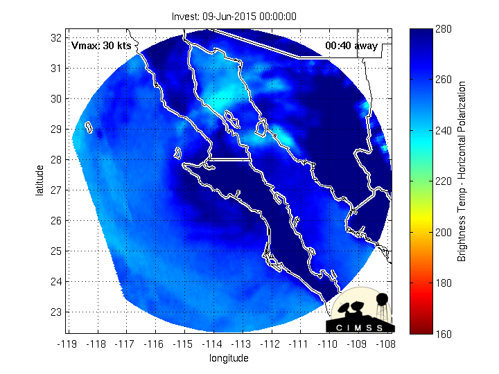
The 12Z Track and Intensity guidance for 94E.
- Attachments
-
-
Carla/Alicia/Jerry(In The Eye)/Michelle/Charley/Ivan/Dennis/Katrina/Rita/Wilma/Humberto/Ike/Harvey
Member: National Weather Association
Facebook.com/Weather Infinity
Twitter @WeatherInfinity
Member: National Weather Association
Facebook.com/Weather Infinity
Twitter @WeatherInfinity