


I don't like to hear that.srainhoutx wrote:I am chatting with Dr. Rick Knabb, Dr. Phil Klotzbach and Jason Samenow while waiting for our flight to depart. The experts suggest we may need to keep an eye on the Gulf this year...
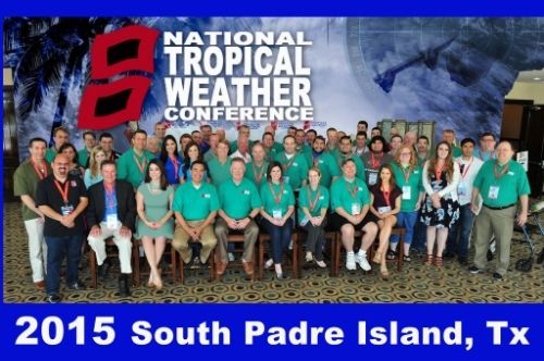
National Tropical Weather Conference 2015
-
srainhoutx

- Site Admin

- Posts: 19616
- Joined: Tue Feb 02, 2010 2:32 pm
- Location: Maggie Valley, NC
- Contact:
Greetings from South Padre Island. Our KHOU Weather Forum is well represented this year!
Carla/Alicia/Jerry(In The Eye)/Michelle/Charley/Ivan/Dennis/Katrina/Rita/Wilma/Humberto/Ike/Harvey
Member: National Weather Association
Facebook.com/Weather Infinity
Twitter @WeatherInfinity
Member: National Weather Association
Facebook.com/Weather Infinity
Twitter @WeatherInfinity


-
srainhoutx
- Site Admin
- Posts: 19616
- Joined: Tue Feb 02, 2010 2:32 pm
- Location: Maggie Valley, NC
- Contact:
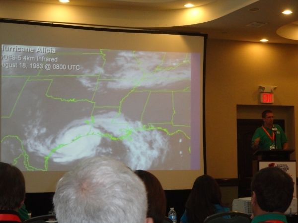
The first day of the 2015 National Hurricane Conference as been eventful. A lot of great information was exchanged as well as some new Advisories concerning storm surge that will be introduced this season. Dr. Richard Knabb (National Hurricane Center Director) explained some the new changes coming this year. A lot of attention was presented regarding the lack of tropical activity expected this season and why we along the Gulf Coast should NOT let our guard down. Typically an El Nino year suggests less activity across the Main Development Region, but do not correlate to less tropical potential for the Gulf of Mexico. The biggest concern is that with a low seasonal forecast, folks will not pay attention and think that we are safe. A lot of time was spent by the various experts advising that we should be prepared and the top analog of 1957 as of April proves that concern. Major Hurricane Audrey with its 145 MPH winds developed in late June and made landfall near the mouth of the Sabine River. It only takes one to make for a very bad season. You will notice the Hurricane that Dr. Knabb mentioned is his presentation below.
Bill Read, Dr. Neil Frank and Dr. Richard Knabb provided an very educational Q and A session and addressed many topics.
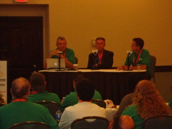

Bill Read, Dr. Neil Frank and Dr. Richard Knabb provided an very educational Q and A session and addressed many topics.

Carla/Alicia/Jerry(In The Eye)/Michelle/Charley/Ivan/Dennis/Katrina/Rita/Wilma/Humberto/Ike/Harvey
Member: National Weather Association
Facebook.com/Weather Infinity
Twitter @WeatherInfinity
Member: National Weather Association
Facebook.com/Weather Infinity
Twitter @WeatherInfinity

I was reading about the hurricane outlook, and someone posted this:
Note though that an El Niño does not impact Gulf of Mexico storms only the Caribbean and Atlantic which means we could see more "home grown" storms this year.
Is that a true statement?
Note though that an El Niño does not impact Gulf of Mexico storms only the Caribbean and Atlantic which means we could see more "home grown" storms this year.
Is that a true statement?
I read that Hurricane Audrey was a Category 3 hurricane based on re-analysis.srainhoutx wrote:The first day of the 2015 National Hurricane Conference as been eventful. A lot of great information was exchanged as well as some new Advisories concerning storm surge that will be introduced this season. Dr. Richard Knabb (National Hurricane Center Director) explained some the new changes coming this year. A lot of attention was presented regarding the lack of tropical activity expected this season and why we along the Gulf Coast should NOT let our guard down. Typically an El Nino year suggests less activity across the Main Development Region, but do not correlate to less tropical potential for the Gulf of Mexico. The biggest concern is that with a low seasonal forecast, folks will not pay attention and think that we are safe. A lot of time was spent by the various experts advising that we should be prepared and the top analog of 1957 as of April proves that concern. Major Hurricane Audrey with its 145 MPH winds developed in late June and made landfall near the mouth of the Sabine River. It only takes one to make for a very bad season. You will notice the Hurricane that Dr. Knabb mentioned is his presentation below.
http://i228.photobucket.com/albums/ee29 ... 9afb86.jpg
Bill Read, Dr. Neil Frank and Dr. Richard Knabb provided an very educational Q and A session and addressed many topics.
http://i228.photobucket.com/albums/ee29 ... 9a0125.jpg
landfall intensity decreased to 105kt (120mph, a major, cat 3)
http://www.aoml.noaa.gov/hrd/hurdat/mwr_pdf/1957.pdf
https://ams.confex.com/ams/31Hurr/webpr ... 44092.html

http://www.aoml.noaa.gov/hrd/hurdat/mwr_pdf/1957.pdf
https://ams.confex.com/ams/31Hurr/webpr ... 44092.html
-
Portastorm

- Posts: 800
- Joined: Wed Feb 03, 2010 3:04 pm
- Location: Southwest Austin/Oak Hill, TX
- Contact:
I'm not certain that statement is entirely accurate. During El Nino years in the western Atlantic basin, the upper level winds tend to be much stronger from the west into the deep tropics. Consequently that tends to shear apart developing tropical cyclones, namely the ones which develop out of the open Atlantic or even closer to the Caribbean (i.e. the longer tracking storms). El Nino does seem to have less of an impact on those cyclones that develop much closer to the CONUS mainland. Good example is Alicia in 1983.sambucol wrote:I was reading about the hurricane outlook, and someone posted this:
Note though that an El Niño does not impact Gulf of Mexico storms only the Caribbean and Atlantic which means we could see more "home grown" storms this year.
Is that a true statement?
-
srainhoutx
- Site Admin
- Posts: 19616
- Joined: Tue Feb 02, 2010 2:32 pm
- Location: Maggie Valley, NC
- Contact:
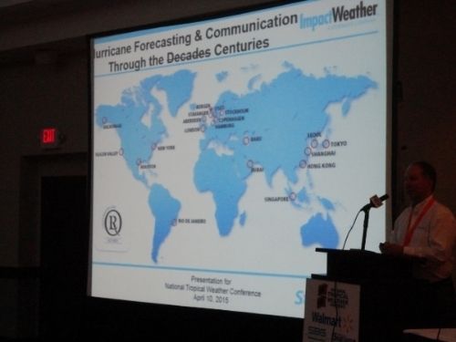
Our own wxman57 giving his presentation " Delivering Tropical Forecasts Globally".

Carla/Alicia/Jerry(In The Eye)/Michelle/Charley/Ivan/Dennis/Katrina/Rita/Wilma/Humberto/Ike/Harvey
Member: National Weather Association
Facebook.com/Weather Infinity
Twitter @WeatherInfinity
Member: National Weather Association
Facebook.com/Weather Infinity
Twitter @WeatherInfinity
-
Texaspirate11

- Posts: 1278
- Joined: Tue Dec 31, 2013 12:24 am
- Contact:
Thanks for all the wonderful updates.
We are with you in spirit.
We are with you in spirit.
Just because you're disabled, you don't have to be a victim
Be Weather Aware & Prepared!
Barbara Jordan Winner in Media
Disability Integration Consultant
Be Weather Aware & Prepared!
Barbara Jordan Winner in Media
Disability Integration Consultant
-
srainhoutx
- Site Admin
- Posts: 19616
- Joined: Tue Feb 02, 2010 2:32 pm
- Location: Maggie Valley, NC
- Contact:
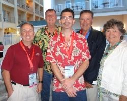
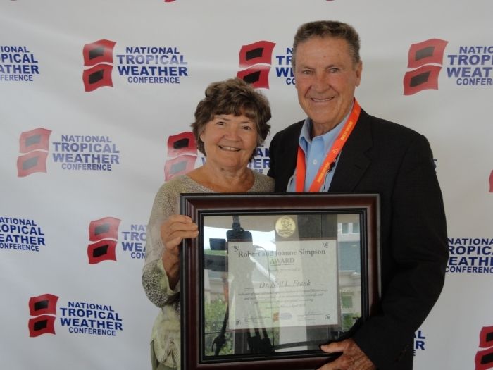
Dr. Neil and Velma Frank after the Robert & Joanne Simpson Award Medal Luncheon and Ceremony was presented to Dr. Neil for his lifetime of service to our Nation and Community. On a personal note... it has been my extreme honor and personal privilege to be able to travel and spend personal one on one time with Dr. Neil the past couple of years while traveling to a couple of conferences. Neil's integrity and ability to communicate in a calm and clear voice is what we try to achieve with our KHOU Weather Forum. His knowledge and decades of experience is second to none in the Tropical Weather field and I am honored to be able to call him friend.
Carla/Alicia/Jerry(In The Eye)/Michelle/Charley/Ivan/Dennis/Katrina/Rita/Wilma/Humberto/Ike/Harvey
Member: National Weather Association
Facebook.com/Weather Infinity
Twitter @WeatherInfinity
Member: National Weather Association
Facebook.com/Weather Infinity
Twitter @WeatherInfinity
You and all the promets do a great job srain! Really miss Dr Neil on the newscast. I don't post much, but always come here for the real scoop on the weather. Great to see everyone!
-
srainhoutx
- Site Admin
- Posts: 19616
- Joined: Tue Feb 02, 2010 2:32 pm
- Location: Maggie Valley, NC
- Contact:
A couple of additional pictures from the 2015 National Tropical Weather Conference.


Carla/Alicia/Jerry(In The Eye)/Michelle/Charley/Ivan/Dennis/Katrina/Rita/Wilma/Humberto/Ike/Harvey
Member: National Weather Association
Facebook.com/Weather Infinity
Twitter @WeatherInfinity
Member: National Weather Association
Facebook.com/Weather Infinity
Twitter @WeatherInfinity