
August 2014 - Showers/Storms Possible To End The Month
-
srainhoutx

- Site Admin

- Posts: 19616
- Joined: Tue Feb 02, 2010 2:32 pm
- Location: Maggie Valley, NC
- Contact:
Drier air and lower dew points in the upper 60's continue to filter S across the northern half of the Region will end any chance of rain except for the Coastal waters the next day or two. Lower morning temperatures will bring a bit of relief to the humid morning lows we have seen near 80 to a comfortable low to mid 70's into Thursday. A weak onshore flow will resume later in the week and slowly increase as a series of upper air disturbances cross the Central Plains ushering in a typical afternoom sea/bay breeze shower/thundershower regime as the upper Ridge flattens out and daily convective temperatures of 90F are met during the weekend into early next week. Seasonal temperatures should continue with no real sign of seeing that 100F mark that was common the past several summers. The tropics remain quiet and that should continue into next week. We may begin to an increase for potential tropical activity across the Atlantic later next week as the African dust begins to lessen and instability increases across the Caribbean Sea and W of the 50 W longitude.area as easterly waves traverse the Main Development Region as they exit the W Coast of Africa.
Carla/Alicia/Jerry(In The Eye)/Michelle/Charley/Ivan/Dennis/Katrina/Rita/Wilma/Humberto/Ike/Harvey
Member: National Weather Association
Facebook.com/Weather Infinity
Twitter @WeatherInfinity
Member: National Weather Association
Facebook.com/Weather Infinity
Twitter @WeatherInfinity
-
srainhoutx
- Site Admin
- Posts: 19616
- Joined: Tue Feb 02, 2010 2:32 pm
- Location: Maggie Valley, NC
- Contact:
Morning Update from Jeff:
Stalled surface front located across the nearshore waters this morning resulting in scattered to numerous convection near and offshore this morning.
Surface dewpoints range from the mid and upper 70’s near the coast to the mid 60’s inland so there is a strong moisture gradient across the area from south to north. Winds returning to the SE today combined with the offshore front washing out will allow moisture to begin to surge back northward into the region. The result will be increasing rain chances south of I-10 today and then across much of the area Friday-Sunday with focus mainly along the seabreeze front each afternoon and near the coast each morning.
Very little change in the upper air pattern into the first part of next week which will keep at least a chance of afternoon thunderstorms in the forecast along with near normal summer temperatures.
Still no 100 degree day yet at IAH for 2014!
Carla/Alicia/Jerry(In The Eye)/Michelle/Charley/Ivan/Dennis/Katrina/Rita/Wilma/Humberto/Ike/Harvey
Member: National Weather Association
Facebook.com/Weather Infinity
Twitter @WeatherInfinity
Member: National Weather Association
Facebook.com/Weather Infinity
Twitter @WeatherInfinity

I got two drops! 

The dog days of summer ..... gotta love mid august weather in SE Texas. I was driving through New Mexico, Arizona, and California last week and man have the monsoons raised havoc in the SW. What I usually see as desert in New Mexico was nothing but flooded out land for miles. We hit a torrential monsoon storm in the deserts of California. The Blythe area was completely flooded out by this storm. Nothing but muddy water everywhere you looked. Fortunately we made it through but some others weren't as lucky. Wish I would've taken some pictures.
~~~When Thunder Roars Go Indoors~~~
~~~Turn Around Don't Drown~~~
~~~Run From The Water, Hide From The Wind~~~
~~~Turn Around Don't Drown~~~
~~~Run From The Water, Hide From The Wind~~~
-
srainhoutx
- Site Admin
- Posts: 19616
- Joined: Tue Feb 02, 2010 2:32 pm
- Location: Maggie Valley, NC
- Contact:
I received a whopping .01 yesterday afternoon as the seabreeze passed NW Harris County and tiny thundershower developed behind the outflow boundary. Just enough to make it steamy. Chances or a shower or two may increase tomorrow as a shear axis offshore of Louisiana drifts W and a weak short wave trough over the Plains drops SE and flattens out the weak upper ridge. Higher PW's and convective temperatures near 90F should allow the sea/bay breeze to fire off showers and storms at least in an isolated fashion across our Region. Aerial coverage may increase tomorrow into Monday, but we will see. The tropics continue to look quiet this morning, but there may be some indications via the longer range guidance as we begin the month of September eyes may need to focus a bit closer to home across the Western Caribbean and possibly the Western Gulf. These waters are virtually untouched and ripe for development...IF we gat a disturbance that begins to develop across those waters. When we were enjoying the somewhat cooler weather in July, the analog dates of 1961, 1999, 2005 and 2008 just kept showing up day after day in the Day 8+ upper air chart analogs. If we can make it to early September without the "C" storm being named, it would be interesting and certainly not out of the question this season. We will continue to monitor the easterly waves moving across Africa and the Eastern Atlantic in our Hurricane Central section as we enter the climatological peak for tropical development across the Atlantic Basin.

Carla/Alicia/Jerry(In The Eye)/Michelle/Charley/Ivan/Dennis/Katrina/Rita/Wilma/Humberto/Ike/Harvey
Member: National Weather Association
Facebook.com/Weather Infinity
Twitter @WeatherInfinity
Member: National Weather Association
Facebook.com/Weather Infinity
Twitter @WeatherInfinity
-
Paul Robison
[quote="srainhoutx"]I received a whopping .01 yesterday afternoon as the seabreeze passed NW Harris County and tiny thundershower developed behind the outflow boundary. Just enough to make it steamy. Chances or a shower or two may increase tomorrow as a shear axis offshore of Louisiana drifts W and a weak short wave trough over the Plains drops SE and flattens out the weak upper ridge. Higher PW's and convective temperatures near 90F should allow the sea/bay breeze to fire off showers and storms at least in an isolated fashion across our Region. Aerial coverage may increase tomorrow into Monday, but we will see. The tropics continue to look quiet this morning, but there may be some indications via the longer range guidance as we begin the month of September eyes may need to focus a bit closer to home across the Western Caribbean and possibly the Western Gulf. These waters are virtually untouched and ripe for development...IF we gat a disturbance that begins to develop across those waters. When we were enjoying the somewhat cooler weather in July, the analog dates of 1961, 1999, 2005 and 2008 just kept showing up day after day in the Day 8+ upper air chart analogs. If we can make it to early September without the "C" storm being named, it would be interesting and certainly not out of the question this season. We will continue to monitor the easterly waves moving across Africa and the Eastern Atlantic in our Hurricane Central section as we enter the climatological peak for tropical development across the Atlantic Basin.
1.) Will all parts of the city see 30-45 mph winds with these storms? (Sounds like some could be severe)
2. Do the forecast models depict a "Carla"-type storm developing in the W. Caribbean or West GOMEX?
Please explain. I'm not a weatherman , of course.
1.) Will all parts of the city see 30-45 mph winds with these storms? (Sounds like some could be severe)
2. Do the forecast models depict a "Carla"-type storm developing in the W. Caribbean or West GOMEX?
Please explain. I'm not a weatherman , of course.
-
srainhoutx
- Site Admin
- Posts: 19616
- Joined: Tue Feb 02, 2010 2:32 pm
- Location: Maggie Valley, NC
- Contact:
The high resolution models have initiated the ongoing showers/storms across the Edwards Plateau and the Metroplex this morning. These higher resolution models also indicate the shear axis will allow a bit more widespread development later today across the Hill Country and SE Texas.
- Attachments
-
Carla/Alicia/Jerry(In The Eye)/Michelle/Charley/Ivan/Dennis/Katrina/Rita/Wilma/Humberto/Ike/Harvey
Member: National Weather Association
Facebook.com/Weather Infinity
Twitter @WeatherInfinity
Member: National Weather Association
Facebook.com/Weather Infinity
Twitter @WeatherInfinity


-
srainhoutx
- Site Admin
- Posts: 19616
- Joined: Tue Feb 02, 2010 2:32 pm
- Location: Maggie Valley, NC
- Contact:
Heat Advisory issued for our Coastal Counties and those Advisories will likely be expanded to include most of SE Texas tomorrow into at least Saturday.
31 Years ago at this hour the center of Hurricane Alicia was passing just W of DT Houston. We had received heavy rain the week before Alicia made landfall across the Region and the ground was very saturated. Tree damage was substantial across SE Texas from a combination of wet soil and the many years that had passed since winds in access of 50 to 60 miles per hour with higher gusts just shy of 100 MPH reported at Hobby Airport. Many will recall the large amount of broken windows in the High Rise buildings throughout DT Houston damaged by flying debris. Almost 10 inches of rain would fall across Liberty County and the Brownwood subdivision along the Upper Galveston Bay in the Eastern part of Baytown would be severely damaged from storm surge and years of subsidence that plagued the area in the 70's due to subsurface water being pumped by industry and municipalities for drinking and cooling water. The conversion to surface water from the various area lakes had already began in 1983 when Alicia struck the West end of Galveston Island in what we SE Texas folk know as the worse case scenario for a landfallIng Major Hurricane affecting the Houston/Galveston Area. 23 Tornadoes were associated with Alicia which was a small Hurricane when compared to Hurricane Carla which hit Port O'Connor along the Middle Texas Coast in September of 1961. Alicia caused an estimated 2 Billion Dollars damage by 1983 standards and if a Hurricane the size of Carla were to take the same track...some estimates suggest that the Dollar damage would exceed 4 times the amount that Alicia brought to the SE Texas/Upper Texas Coastal area.
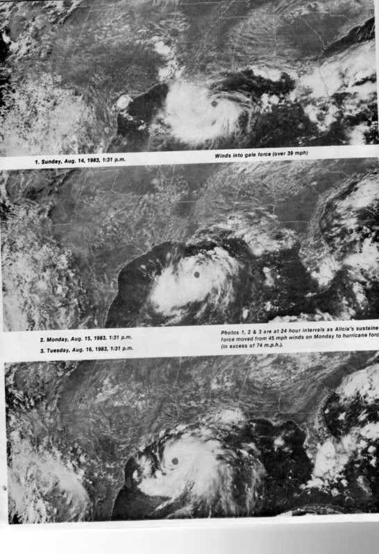
31 Years ago at this hour the center of Hurricane Alicia was passing just W of DT Houston. We had received heavy rain the week before Alicia made landfall across the Region and the ground was very saturated. Tree damage was substantial across SE Texas from a combination of wet soil and the many years that had passed since winds in access of 50 to 60 miles per hour with higher gusts just shy of 100 MPH reported at Hobby Airport. Many will recall the large amount of broken windows in the High Rise buildings throughout DT Houston damaged by flying debris. Almost 10 inches of rain would fall across Liberty County and the Brownwood subdivision along the Upper Galveston Bay in the Eastern part of Baytown would be severely damaged from storm surge and years of subsidence that plagued the area in the 70's due to subsurface water being pumped by industry and municipalities for drinking and cooling water. The conversion to surface water from the various area lakes had already began in 1983 when Alicia struck the West end of Galveston Island in what we SE Texas folk know as the worse case scenario for a landfallIng Major Hurricane affecting the Houston/Galveston Area. 23 Tornadoes were associated with Alicia which was a small Hurricane when compared to Hurricane Carla which hit Port O'Connor along the Middle Texas Coast in September of 1961. Alicia caused an estimated 2 Billion Dollars damage by 1983 standards and if a Hurricane the size of Carla were to take the same track...some estimates suggest that the Dollar damage would exceed 4 times the amount that Alicia brought to the SE Texas/Upper Texas Coastal area.
- Attachments
-
-
Carla/Alicia/Jerry(In The Eye)/Michelle/Charley/Ivan/Dennis/Katrina/Rita/Wilma/Humberto/Ike/Harvey
Member: National Weather Association
Facebook.com/Weather Infinity
Twitter @WeatherInfinity
Member: National Weather Association
Facebook.com/Weather Infinity
Twitter @WeatherInfinity

I know it's probably in the upper levels, but South of Brownsville looks a little interesting to me.
http://www.ssd.noaa.gov/goes/east/gmex/mflash-rgb.html
http://www.ssd.noaa.gov/goes/east/gmex/mflash-rgb.html
-
srainhoutx
- Site Admin
- Posts: 19616
- Joined: Tue Feb 02, 2010 2:32 pm
- Location: Maggie Valley, NC
- Contact:
That upper low is drifting N from near the Tampico area and should enhance rain chances across the Lower Texas Coast/Rio Grande Valley Region into Wednesday. There is also a TUTT low moving W near Cuba as well as a tropical wave nearing the Yucatan Peninsula moving W that is likely to increase tropical moisture into Wednesday as well.

Carla/Alicia/Jerry(In The Eye)/Michelle/Charley/Ivan/Dennis/Katrina/Rita/Wilma/Humberto/Ike/Harvey
Member: National Weather Association
Facebook.com/Weather Infinity
Twitter @WeatherInfinity
Member: National Weather Association
Facebook.com/Weather Infinity
Twitter @WeatherInfinity
-
srainhoutx
- Site Admin
- Posts: 19616
- Joined: Tue Feb 02, 2010 2:32 pm
- Location: Maggie Valley, NC
- Contact:
The models are doing a poor job of initiating the convection associated with the shear axis and meso vort across Central and West Central Texas extending NE to just W of the Metroplex. Heavy flooding rainfall has occurred overnight across portions of the Edwards Plateau near Uvalde extending NE across the head waters of the Hill Country Highland Lakes. This area of showers and storms should diminish and slowly shift NE above the upper Ridge across the SE US as a rather strong short wave passes N of the upper ridge across the Ohio Valley into the Mid Atlantic. To our W, copious moisture originating from the Eastern Pacific is dropping heavy rainfall across Old Mexico into the Desert SW where we see monsoonal moisture 1 to 2 standard deviations above normal allowing heavy monsoonal rains across portions of Southern California into Arizona continue.
Closer to home a Heat Advisory continues our Coastal Counties. S of Texas across the Gulf Coast of Mexico the upper low that brought attention to the storminess near Tampico continues to drift N. A tropical wave is crossing the Yucatan with enhanced deep tropical moisture spreading NW into the Western Gulf. Scattered showers and storms look likely during the late morning into the afternoon hours during peak heating along the various sea/bay breeze boundaries. We may begin to dry out a bit on Thursday, but with poor performance of the various computer, a chance of at least isolated showers and storms seems like the best bet at this time.
There are some indications that both the Tropical Eastern Pacific as well as the Tropical Atlantic may be heating up with several areas of tropical mischief to monitor. Across the Eastern Pacific a very robust Kelvin Wave is progressing E which will enhance tropical convection with increasing chances of tropical cyclone development along the West Coast of Mexico later this week. There are some indications as this Kelvin wave moves into the Western Atlantic Basin next week, conditions may become a bit more favorable for tropical development across the Caribbean Sea and the Gulf of Mexico. The fly in the ointment is that the Bermuda Ridge looks to continue building W into the SE US and the general steering flow would favor any disturbances to track W to WNW. Easterly tropical waves continue to march W across Africa and across the Atlantic this morning. We continue to steadily head toward peak season for Tropical development, so keep a close eye on the Caribbean Sea and the Gulf over the next week or so just in case something decides to spin up. We will keep an eye on the Tropics and update as need be. Typically as school starts, folks attention turn elsewhere, so those that are weather wise check in daily for any updates as we monitor the latest weather trends.
Carla/Alicia/Jerry(In The Eye)/Michelle/Charley/Ivan/Dennis/Katrina/Rita/Wilma/Humberto/Ike/Harvey
Member: National Weather Association
Facebook.com/Weather Infinity
Twitter @WeatherInfinity
Member: National Weather Association
Facebook.com/Weather Infinity
Twitter @WeatherInfinity
Srain, where is the Bermuda high currently located? I'm trying to find a map showing the current position, with no luck. When the Bermuda ridge moves into the SE US, that generally means for the Gulf to be on alert, correct?srainhoutx wrote:The models are doing a poor job of initiating the convection associated with the shear axis and meso vort across Central and West Central Texas extending NE to just W of the Metroplex. Heavy flooding rainfall has occurred overnight across portions of the Edwards Plateau near Uvalde extending NE across the head waters of the Hill Country Highland Lakes. This area of showers and storms should diminish and slowly shift NE above the upper Ridge across the SE US as a rather strong short wave passes N of the upper ridge across the Ohio Valley into the Mid Atlantic. To our W, copious moisture originating from the Eastern Pacific is dropping heavy rainfall across Old Mexico into the Desert SW where we see monsoonal moisture 1 to 2 standard deviations above normal allowing heavy monsoonal rains across portions of Southern California into Arizona continue.
Closer to home a Heat Advisory continues our Coastal Counties. S of Texas across the Gulf Coast of Mexico the upper low that brought attention to the storminess near Tampico continues to drift N. A tropical wave is crossing the Yucatan with enhanced deep tropical moisture spreading NW into the Western Gulf. Scattered showers and storms look likely during the late morning into the afternoon hours during peak heating along the various sea/bay breeze boundaries. We may begin to dry out a bit on Thursday, but with poor performance of the various computer, a chance of at least isolated showers and storms seems like the best bet at this time.
There are some indications that both the Tropical Eastern Pacific as well as the Tropical Atlantic may be heating up with several areas of tropical mischief to monitor. Across the Eastern Pacific a very robust Kelvin Wave is progressing E which will enhance tropical convection with increasing chances of tropical cyclone development along the West Coast of Mexico later this week. There are some indications as this Kelvin wave moves into the Western Atlantic Basin next week, conditions may become a bit more favorable for tropical development across the Caribbean Sea and the Gulf of Mexico. The fly in the ointment is that the Bermuda Ridge looks to continue building W into the SE US and the general steering flow would favor any disturbances to track W to WNW. Easterly tropical waves continue to march W across Africa and across the Atlantic this morning. We continue to steadily head toward peak season for Tropical development, so keep a close eye on the Caribbean Sea and the Gulf over the next week or so just in case something decides to spin up. We will keep an eye on the Tropics and update as need be. Typically as school starts, folks attention turn elsewhere, so those that are weather wise check in daily for any updates as we monitor the latest weather trends.
-
srainhoutx
- Site Admin
- Posts: 19616
- Joined: Tue Feb 02, 2010 2:32 pm
- Location: Maggie Valley, NC
- Contact:
A good source for the current and projected surface analysis for the Tropical Atlantic is on the NHC Marine Forecast Atlantic and Pacific page. I also utilize the Analysis Tools page to 'see' the various easterly waves as well as the dust (SAL) on visible imagery across the Tropical Atlantic. Doc Neil and I had a great discussion in late July about utilizing these tools and the importance they play for the NHC forecasters when determining whether or not to issue or designate 'INVEST's'. Typically when we see showers and storms continue to pulse over a 48 to 72 hour period, it gets the attention of the forecaster. Disturbances that maintain convection as they near land masses, particularly generate interest.JamieP wrote:
Srain, where is the Bermuda high currently located? I'm trying to find a map showing the current position, with no luck. When the Bermuda ridge moves into the SE US, that generally means for the Gulf to be on alert, correct?
http://www.nhc.noaa.gov/marine/
http://www.nhc.noaa.gov/analysis_tools.php
Carla/Alicia/Jerry(In The Eye)/Michelle/Charley/Ivan/Dennis/Katrina/Rita/Wilma/Humberto/Ike/Harvey
Member: National Weather Association
Facebook.com/Weather Infinity
Twitter @WeatherInfinity
Member: National Weather Association
Facebook.com/Weather Infinity
Twitter @WeatherInfinity

A poster on another forum noticed the 06 GFS at 264 hour...
http://www.tropicaltidbits.com/analysis ... _watl.html
http://www.tropicaltidbits.com/analysis ... _watl.html
Thank you Srain! Hmm, very interesting Kludge.... 
Now the 12Z GFS moves it over to New Orleans instead, but does so 36 hours earlier...