Page 99 of 105
Re: January: Strong Arctic Front/Winter Storm Warning/Adviso
Posted: Tue Jan 28, 2014 1:25 pm
by cperk
wxman57 wrote:12Z Euro indicating widespread snow across south and SE TX next Friday. We shall see...
wxman57 are you sure you're not looking at your maps upside down.

Re: January: Strong Arctic Front/Winter Storm Warning/Adviso
Posted: Tue Jan 28, 2014 1:30 pm
by Kingwood31
We may turn wx57 in to a snow junkie after all

Re: January: Strong Arctic Front/Winter Storm Warning/Adviso
Posted: Tue Jan 28, 2014 1:33 pm
by Ptarmigan
wxman57 wrote:Kingwood31 wrote:wxman57 wrote:12Z Euro indicating widespread snow across south and SE TX next Friday. We shall see...
Are you serious wx57??i mean really lol
I'm just reporting what the 240-hr Euro panel is indicating.
That is 10 days away. Anything can change. Would be nice though.

Re: January: Strong Arctic Front/Winter Storm Warning/Adviso
Posted: Tue Jan 28, 2014 1:35 pm
by WX201
Why is moisture seeming to reload into west Texas??? Somebody???
Re: January: Strong Arctic Front/Winter Storm Warning/Adviso
Posted: Tue Jan 28, 2014 1:38 pm
by Katdaddy
LOL Wxman57! You just had to stir it up about next week

We shall see…….
Re: January: Strong Arctic Front/Winter Storm Warning/Adviso
Posted: Tue Jan 28, 2014 1:40 pm
by srainhoutx
WX201, that mid/upper level moisture is associated with that upper low over Mexico. There is a tap of Eastern Pacific moisture that is ejecting E into Texas. Sleet continues here in NW Harris County albeit light at this hour.
Re: January: Strong Arctic Front/Winter Storm Warning/Adviso
Posted: Tue Jan 28, 2014 1:41 pm
by wxman57
cperk wrote:wxman57 wrote:12Z Euro indicating widespread snow across south and SE TX next Friday. We shall see...
wxman57 are you sure you're not looking at your maps upside down.
They appear to be right-side-up. Here's a graphic from my workstation. It's 24hr precip but really only covers about 12hrs as the precip is just reaching east TX. Values are in centimeters, so 5cm = 2", 15cm = 6", etc. The dark blue line is the surface freezing line.

Re: January: Strong Arctic Front/Winter Storm Warning/Adviso
Posted: Tue Jan 28, 2014 1:44 pm
by SusieinLP
I'm ready for some good spring showers!!
Re: January: Strong Arctic Front/Winter Storm Warning/Adviso
Posted: Tue Jan 28, 2014 1:46 pm
by WX201
srainhoutx wrote:WX201, that mid/upper level moisture is associated with that upper low over Mexico. There is a tap of Eastern Pacific moisture that is ejecting E into Texas. Sleet continues here in NW Harris County albeit light at this hour.
So question...as that moves East, does it tap any additional Gulf moisture and deliver any additional precipitation? Or will the lower layers be to dry?
Re: January: Strong Arctic Front/Winter Storm Warning/Adviso
Posted: Tue Jan 28, 2014 1:50 pm
by davidiowx
WX201 wrote:srainhoutx wrote:WX201, that mid/upper level moisture is associated with that upper low over Mexico. There is a tap of Eastern Pacific moisture that is ejecting E into Texas. Sleet continues here in NW Harris County albeit light at this hour.
So question...as that moves East, does it tap any additional Gulf moisture and deliver any additional precipitation? Or will the lower layers be to dry?
Looks like it will be to dry. I would love to see some surprises though
Re: January: Strong Arctic Front/Winter Storm Warning/Adviso
Posted: Tue Jan 28, 2014 1:54 pm
by Baseballdude2915
davidiowx wrote:WX201 wrote:srainhoutx wrote:WX201, that mid/upper level moisture is associated with that upper low over Mexico. There is a tap of Eastern Pacific moisture that is ejecting E into Texas. Sleet continues here in NW Harris County albeit light at this hour.
So question...as that moves East, does it tap any additional Gulf moisture and deliver any additional precipitation? Or will the lower layers be to dry?
Looks like it will be to dry. I would love to see some surprises though
Radar returns showing a little building along I-10 and south to Victoria. I wonder if its making it to the ground.. but we arent in the clear yet. Will be light precip but I'd think all sleet/snow if it makes it this far. Dry air is sweeping in though.
Re: January: Strong Arctic Front/Winter Storm Warning/Adviso
Posted: Tue Jan 28, 2014 1:58 pm
by michmich
Still very light sleet and 28 degrees here...
Re: January: Strong Arctic Front/Winter Storm Warning/Adviso
Posted: Tue Jan 28, 2014 2:16 pm
by GBinGrimes
Kingwood31 wrote:Would that set a record if it verified..3 winter storms in hou..has it ever happend?
In '73 it snowed three times in Houston, and not just small amounts. Each snow left enough on the ground to make snowmen and the first snowfall remained on the ground for several days. A series of wondrous events for an elementary school kid.
Re: January: Strong Arctic Front/Winter Storm Warning/Adviso
Posted: Tue Jan 28, 2014 2:18 pm
by cperk
wxman57 wrote:cperk wrote:wxman57 wrote:12Z Euro indicating widespread snow across south and SE TX next Friday. We shall see...
wxman57 are you sure you're not looking at your maps upside down.
They appear to be right-side-up. Here's a graphic from my workstation. It's 24hr precip but really only covers about 12hrs as the precip is just reaching east TX. Values are in centimeters, so 5cm = 2", 15cm = 6", etc. The dark blue line is the surface freezing line.
http://home.comcast.net/~cgh57/neweuro.gif
Thank you for this graphic and your great service to this forum.
Re: January: Strong Arctic Front/Winter Storm Warning/Adviso
Posted: Tue Jan 28, 2014 2:22 pm
by jasons2k
Looks like a tad more lift along the I-10 corridor out west moving this way - maybe some more flurries/sleet pellets...
Re: January: Strong Arctic Front/Winter Storm Warning/Adviso
Posted: Tue Jan 28, 2014 2:25 pm
by djmike
Im sure its moving out now, but...ummm...NWS LCH just updated our forecast! Rest of today, tonight and tomorrow! I have a feeling they are looking at the majority of LA instead of our little section they forecast for. I was sure they were going to lower it now that the main event has passed. surprises? Maybe, maybe not.
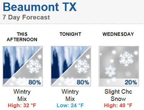
- tonight.PNG (74.32 KiB) Viewed 4489 times
Beaumont/NWSLCH
This Afternoon - Freezing rain and sleet. High near 32. North wind around 15 mph, with gusts as high as 20 mph. Chance of precipitation is 80%. Total daytime ice accumulation of 0.1 to 0.3 of an inch possible. Total daytime sleet accumulation of less than a half inch possible.
Tonight - Freezing rain and sleet before 7pm, then a chance of snow and sleet between 7pm and 1am, then a slight chance of snow after 1am. Low around 24. North wind around 10 mph. Chance of precipitation is 80%. Little or no ice accumulation expected. New snow and sleet accumulation of less than a half inch possible.
Wednesday - A 20 percent chance of snow before 7am. Mostly sunny, with a high near 40. Northeast wind 5 to 10 mph.
Re: January: Strong Arctic Front/Winter Storm Warning/Adviso
Posted: Tue Jan 28, 2014 2:28 pm
by cperk
Starting to sleet here again and 32 degrees.
Re: January: Strong Arctic Front/Winter Storm Warning/Adviso
Posted: Tue Jan 28, 2014 2:36 pm
by weatherag
Light sleet at my house near Memorial Park.
Re: January: Strong Arctic Front/Winter Storm Warning/Adviso
Posted: Tue Jan 28, 2014 2:38 pm
by sambucol
Watching TV, and ch 2 came in with a winter weather report. Frank Billingsley said this is not over, clearing is not happening as was expected, so ice won't have an opportunity to melt from bridges and overpasses. Also said he won't be surprised if our winter weather advisory is extended beyond 4 pm.
Re: January: Strong Arctic Front/Winter Storm Warning/Adviso
Posted: Tue Jan 28, 2014 2:41 pm
by sambucol
Sleeting fairly heavily now. 27 degrees.