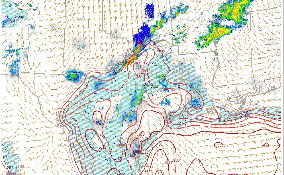
Folks there is a lot of severe weather breaking out across SE Texas into the Dallas/Ft Worth area. Reports of a wall could spotted just N of the Texas A & M Campus, so don't forget the severe side of this incoming storm system.
Surface based Cape values are quite impressive, especially S/E of Metroplex and also along upper Texas coastal areas and S/West of greater Houston. A severe thunderstorm warning for the Metroplex in effect as front drives South tapping the warm moist air surging towards the boundary. Hail appears to be the primary threat with these elevated storms and we may see a surge of activity break out tomorrow morning as the front approaches.
GFS coming in stronger/ colder sunday night/ monday morning. Looks like some of our NW counties may see a little wintry precip. The main key in determining p-types will most likely depend on the dry slot that could appear in the mid levels. If enough evaporation occurs FR could occur. This area of freezing temps is very shallow in depth (only about 800m) before their is a strong inversion at 900mb. It is going to be a close one and any difference in temperature is going to be crucial.
KCLL Skew T (notice the inversion only a 1000m up)
2894.GIF
925mb HT, Temp, and Winds:
gfs_namer_072_925_temp_ht.gif
Also to note the High-res NAM seems to indicate that some sightly elevated storms could be possible Saturday (especially for the counties to the north) and transition south throughout the day/night
nam-hires_namer_039_sim_reflectivity.gif
For Your Infinite Source For All Things Weather Visit Our Facebook
Years That Had 32°F or Below In November At KIAH
1969
1970
1972
1974
1975
1976
1977
1979
1980
1984
1987
1990
1991
1992
1993
1997
1999
2006
2010
Some of these Novembers are the coldest on record.
Top 10 Coolest
51.8 1976*
54.4 1889
54.7 1972*
55.0 1929
55.7 1997*
55.7 1979*
56.1 1898
56.5 1959
56.7 1991*
56.8 1992*
* At KIAH
Some of these cold Novembers had cold winters like 1972-1973, 1976-1977, and 1977-1978. November 1989 had record highs of 89°F and December 1989 was cold.
NWS Ft Worth/Dallas issues Winter Storm Watch for Sunday across the Metroplex. NWS San Antonio/Austin issues Winter Weather Advisory for portions of the Hill Country for Tonight into Saturday.
The latest update from the WPC/HPC Winter Weather desk suggests that portions of SW/Central Texas may see icing greater than 0.25 Inch and they may need to expand their Day 3 Outlook further S and E later today.. The Euro/SREF is suggesting the Northern portions of SE Texas may need Winter Weather Advisories for Sunday night into early Monday.
Carla/Alicia/Jerry(In The Eye)/Michelle/Charley/Ivan/Dennis/Katrina/Rita/Wilma/Humberto/Ike/Harvey
Member: National Weather Association
Facebook.com/Weather Infinity
Twitter @WeatherInfinity
Front has cleared my area of NW Harris County. Gusty NW winds to just below 30 mph and temps dropped from 72 to 58 in less than ten minutes. I'ts going to be a miserable 4-5 days across our Region. The morning commute is not going to be pleasant with the heavy rains.
Carla/Alicia/Jerry(In The Eye)/Michelle/Charley/Ivan/Dennis/Katrina/Rita/Wilma/Humberto/Ike/Harvey
Member: National Weather Association
Facebook.com/Weather Infinity
Twitter @WeatherInfinity
Arctic boundary is blasting through SE TX currently. Temperature is 46 at College Station with NW Winds gusting to 26 while it is 74 at Sugar Land. Front is making very good progress and will be off the coast by late morning/noon. High temperatures will be in the next few hours and then it will be a quick drop into the low 50’s as the front passes and into the 40’s by afternoon under strong NW winds and cloudy conditions with continued periods of rainfall. Line of thunderstorms has developed along the front producing a quick bout of heavy rainfall and gusty winds. The area will likely not see high temperatures above 60 again until possibly Thanksgiving day.
Tonight-Saturday night:
Arctic cold dome builds into TX with temperatures hovering in the 40’s and 30’s through this period. Upstream SW flow aloft will provide a few disturbances to ride up and over the surface cold air producing periods of rain and showers through Saturday. Increasingly drier air will filter SW into the region from the NE helping to end rainfall from the NE by late Saturday. Temperatures should remain above freezing across our entire area through this period so everything should be liquid. Ice could be a problem NW of a line from Fort Worth to Waco starting this afternoon.
Sunday-Monday:
Major winter storm heading for TX with significant impacts likely
Large upper level storm system will lift into the state out of the SW US late this weekend with cold air locked in place. The result will be a variety of liquid/freezing/frozen precipitation across a large part of TX from Sunday into Monday.
SE TX:
Coastal low will form late Sunday off the lower TX coast in response to large scale lift arriving from the west. This low will sling copious moisture northward into SE TX by afternoon with cloud decks lowering and thickening. Surface layer will dry out Saturday evening and then moisten again on Sunday. Expect to see rainfall develop from SW to NE late in the day and overspread much of the region Sunday night into Monday morning and jet dynamics and lift are increased. I am concerned with the P-type onset of the precipitation Sunday night north of a line from Brenham to Conroe to Livingston. With dry air in place below the cloud base layer there could be just enough wet bulb cooling to allowing a shrinking warm nose in the mid layer to allow onset as sleet. Other concern is surface temperatures in the mid 30’s north of the above mentioned line which with some evaporative cooling could drop to near freezing allowing for some freezing rain. Still too early to be confident in anything this far out, but there is a chance of some frozen/freezing precp. Monday morning north of a Brenham to Conroe to Livingston line. South of this line all rainfall will remain liquid as temperatures will hold in the upper 30’s to near 40 on Monday under widespread rainfall. Could even deal will some heavy rainfall along and south of US 59 depending on exactly where the coastal low tracks.
Tides could also become a problem on Monday as the pressure gradient really intensifies over the NW Gulf and strong ENE to NE winds push water toward the coast.
NC TX/Hill Country/NW TX:
Major winter storm expected with accumulations of ice and sleet. Onset of precipitation along and west of I-35 (Dallas to Waco area and then WSW into the Hill Country) on Sunday will be likely in the form of widespread sleet falling into a surface layer at or below freezing. Soundings suggest a prolonged sleet/freezing rain event from Sunday into midday Monday with some significant accumulations possible. NAM is showing significant snowfall in this area, but likely has the incorrect P-type as the forecast soundings show a defined warm nose and a fairly classic sleet profile. If the warm nose is a little deeper then the main result could be freezing rain and significant ice buildup. The most likely event at this point is likely a combination of sleet and freezing rain mix resulting in a crusty and heavy glazing of bridges and overpasses. Many trees still have foliage and icing will result in problems with trees and power lines. Not confident yet on ice/sleet accumulations, but some of the guidance is yielding upwards of an inch of sleet/ice mix in this region which would be a very significant ice storm event.
Tuesday-Thanksgiving:
Coastal and upper level storm move eastward with drying across the state, but still cold conditions. Should see clearing skies on Wednesday, but clouds may already start to return on Thanksgiving Day with continued cold conditions on lows in the 30’s and highs in the 50’s.
Note:
Persons with travel plans to the N and NW of SE TX this weekend should be fully aware of the potential winter storm impacts which will linger well into early next week. Numerous watches and advisories will be issued today to cover the various coming impacts. As with all winter weather events, the forecast will change and considering we are still about 48 hours from the onset of the event there remains a fair degree of uncertainty.
The following products have been issued west of a line from Dallas to west of Waco to Del Rio:
Winter Storm Watch
Winter Weather Advisory
Freezing Rain Advisory
Attachments
Carla/Alicia/Jerry(In The Eye)/Michelle/Charley/Ivan/Dennis/Katrina/Rita/Wilma/Humberto/Ike/Harvey
Member: National Weather Association
Facebook.com/Weather Infinity
Twitter @WeatherInfinity
Morning Porta from between Houston and Galveston. Front just making it's way through S/E Houston now with a pretty impressive line of showers with some embedded thunderstorms. Will be up in Llano area tomorrow through next week...will try and provide updates on conditions while up there. How does Austin area look for wintry precip chances? My daughter is up there at UT.
PaulEInHouston wrote:Morning Porta from between Houston and Galveston. Front just making it's way through S/E Houston now with a pretty impressive line of showers with some embedded thunderstorms. Will be up in Llano area tomorrow through next week...will try and provide updates on conditions while up there. How does Austin area look for wintry precip chances? My daughter is up there at UT.
Well, you'll certainly have some interesting weather to report on when you're up in Llano County. I'm thinking you'll see some winter up there.
As srainhoutx showed with the map, it's going to be real close here in Austin in terms of whether we see an wintry mix or freezing rain or sleet. Our best chances would probably come Sunday into Monday. Right now, it looks like the metro area will stay just wet but that is subject to change.
MESOSCALE DISCUSSION 2035
NWS STORM PREDICTION CENTER NORMAN OK
1000 AM CST FRI NOV 22 2013
AREAS AFFECTED...SWRN-CNTRL OK
CONCERNING...WINTER MIXED PRECIPITATION
VALID 221600Z - 222000Z
SUMMARY...MIX OF SLEET AND FREEZING RAIN WILL SPREAD ACROSS SWRN
INTO CNTRL OK INTO THE EARLY AFTERNOON HOURS.
DISCUSSION...SUBTLE WEAK WARM ADVECTION ATOP ARCTIC ANTICYCLONE
APPEARS TO BE PRIMARILY RESPONSIBLE FOR RASH OF POST FRONTAL SHOWERS
EVOLVING ACROSS NORTH TX INTO SRN OK. OVER THE LAST SEVERAL HOURS A
MORE CONCENTRATED CLUSTER OF SHOWERS HAS EVOLVED OVER NWRN TX/SWRN
OK. MEAN FLOW WOULD FAVOR THIS ACTIVITY SPREADING NEWD ALONG/JUST
NORTH OF THE I-44 CORRIDOR INTO CNTRL OK OVER THE NEXT SEVERAL
HOURS.
12 SOUNDINGS FROM OUN/AMA/MAF ALL EXHIBIT A VERY WARM LAYER THAT
WILL ENSURE AT LEAST A MIXED PHASE OF PRECIPITATION.
ADDITIONALLY...WEAK ELEVATED INSTABILITY RESIDES ACROSS NWRN TX AND
THIS WILL ENCOURAGE DEEPER CONVECTIVE ELEMENTS THAT MAY PRODUCE
LOCALLY HEAVIER PRECIP RATES. LATEST WINTER ALGORITHMS SUGGEST ICE
PELLETS WILL BE COMMON EARLY ACROSS SWRN OK BUT FREEZING RAIN MAY
BECOME MORE DOMINANT BY AFTERNOON FARTHER EAST WHERE BOUNDARY LAYER
IS NOT AS COOL AS POINTS WEST.
WHILE MORE CONCENTRATED CORRIDOR FOR PRECIPITATION SHOULD BE
ALONG/JUST NORTH OF I-44...AFOREMENTIONED CONVECTION ACROSS NWRN TX
SHOULD GRADUALLY LIFT/DEVELOP INTO SRN OK BUT THIS ACTIVITY IS
EXPECTED TO REMAIN MORE SHOWERY IN NATURE. HEAVIEST PRECIP RATES
COULD EXCEED .05 INCHES PER HOUR.
..DARROW.. 11/22/2013
ATTN...WFO...OUN...
Attachments
Carla/Alicia/Jerry(In The Eye)/Michelle/Charley/Ivan/Dennis/Katrina/Rita/Wilma/Humberto/Ike/Harvey
Member: National Weather Association
Facebook.com/Weather Infinity
Twitter @WeatherInfinity
EXTENDED FORECAST DISCUSSION
NWS WEATHER PREDICTION CENTER COLLEGE PARK MD
1109 AM EST FRI NOV 22 2013
VALID 12Z MON NOV 25 2013 - 12Z FRI NOV 29 2013
...MODEL SPREAD--AND STAKES--REMAIN HIGH WITH FUTURE OF
SOUTHWESTERN TROUGH...
WITH THE FLOW OVER CENTRAL NORTH AMERICA EXPECTED TO OPEN BY THE
MEDIUM RANGE, IMPORTANT SHIFTS IN SENSIBLE WEATHER WILL FOLLOW.
UNFORTUNATELY, THE LOCATION AND TYPE OF POTENTIAL HAZARDS ARE FAR
FROM CLEAR AT THIS POINT. THE KEY PLAYERS ARE THE POSITIVE-TILT
TROUGH CURRENTLY LODGED OVER NORTHERN MEXICO AND THE UNITED STATES
DESERT SOUTHWEST, AND THE STREAM OF CLIPPER SYSTEMS DIPPING INTO
THE CANADIAN-BORDER STATES. TIMING AND AMPLITUDE ARE BOTH
CRITICAL--AND SERIOUSLY IN QUESTION. IF THE SOUTHWESTERN WAVE
EMERGES OVER THE NORTHERN GULF OF MEXICO DURING A SLACKENING OF
THE NORTHERN STREAM ENERGY, IT WILL MAKE CONSIDERABLE INROADS INTO
THE EASTERN UNITED STATES. IF NOT, MUCH OF THE SOUTHERN STREAM
MOISTURE AND DYNAMICS WILL BE HERDED TO THE ATLANTIC COAST OR
POINTS OFFSHORE. RELIED ON THE 00Z/22 EUROPEAN CENTRE ENSEMBLE
MEAN AS A SYNOPTIC GUIDE FOR THE WHOLE NATION, LARGELY DUE TO ITS
INHERENT STABILITY VIA THE SHEAR NUMBER OF INDIVIDUAL ENSEMBLE
MEMBERS--AND ITS SKILLFUL TRACK RECORD. RAIN, THUNDERSTORMS, ICE,
SNOW, AND HIGH WINDS ARE ALL POSSIBLE THREATS FACING MUCH OF THE
CENTRAL AND EASTERN UNITED STATES ON THE BUSY TRAVEL DAYS BEFORE
THANKSGIVING NEXT WEEK. WILL HOPEFULLY HAVE A BETTER HANDLE ON THE
SPECIFICS ONCE THE SOUTHWESTERN TROUGH ACTUALLY BEGINS TO MOVE.
CISCO
Carla/Alicia/Jerry(In The Eye)/Michelle/Charley/Ivan/Dennis/Katrina/Rita/Wilma/Humberto/Ike/Harvey
Member: National Weather Association
Facebook.com/Weather Infinity
Twitter @WeatherInfinity
I spent the morning doing live shots, and I can tell you roads are a mess! I doubt temps will push 30 until Monday. Whatever is falling (freezing rain/sleet combo) if freezing on even surface roads. To think about snow on top of this come Saturday night, and Sunday...
I spent the morning doing live shots, and I can tell you roads are a mess! I doubt temps will push 30 until Monday. Whatever is falling (freezing rain/sleet combo) if freezing on even surface roads. To think about snow on top of this come Saturday night, and Sunday...
Welcome back weatherguy425.
Not to put the "cart before the horse" so to speak, but the GFS in the extended range has been suggesting we will do this all again early in December. But that will be a different Topic.
Attachments
Carla/Alicia/Jerry(In The Eye)/Michelle/Charley/Ivan/Dennis/Katrina/Rita/Wilma/Humberto/Ike/Harvey
Member: National Weather Association
Facebook.com/Weather Infinity
Twitter @WeatherInfinity
I spent the morning doing live shots, and I can tell you roads are a mess! I doubt temps will push 30 until Monday. Whatever is falling (freezing rain/sleet combo) if freezing on even surface roads. To think about snow on top of this come Saturday night, and Sunday...
Welcome back weatherguy425.
Not to put the "cart before the horse" so to speak, but the GFS in the extended range has been suggesting we will do this all again early in December. But that will be a different Topic.
Does the GFS show any winter fun for us in SE Texas?
The trend for sleet or freezing rain certainly is shifting much further south and east compared to yesterdays N/NW/Ctrl Tx forecast! Everything seems to be determined by a degree or two difference in the mid/upper atmosphere. Silly, but I hope this trend continues and I get to see 1 pellet here in the Beaumont area. Yes, just 1. I'll be happy camper... lol