
Long Range Model Thread.
-
srainhoutx

- Site Admin

- Posts: 19616
- Joined: Tue Feb 02, 2010 2:32 pm
- Location: Maggie Valley, NC
- Contact:
Perhaps some development in the SW Caribbean in a few more days. ECMWF, GFS, Nogaps, CMC are all trying to sniff something out. Perhaps some model fantasy, but with the MJO pulse heading toward the region we are getting close to that time of the year. 
Carla/Alicia/Jerry(In The Eye)/Michelle/Charley/Ivan/Dennis/Katrina/Rita/Wilma/Humberto/Ike/Harvey
Member: National Weather Association
Facebook.com/Weather Infinity
Twitter @WeatherInfinity
Member: National Weather Association
Facebook.com/Weather Infinity
Twitter @WeatherInfinity

for whatever little bit an off-hour GFS run is worth, the 18z did continue to show a more compact, closed low forming around sunday in the southwest carib.
-
srainhoutx
- Site Admin
- Posts: 19616
- Joined: Tue Feb 02, 2010 2:32 pm
- Location: Maggie Valley, NC
- Contact:
Welcome to the 'local forum' msp. We have a few A & M students and Alumni around here.msp wrote:for whatever little bit an off-hour GFS run is worth, the 18z did continue to show a more compact, closed low forming around sunday in the southwest carib.
Carla/Alicia/Jerry(In The Eye)/Michelle/Charley/Ivan/Dennis/Katrina/Rita/Wilma/Humberto/Ike/Harvey
Member: National Weather Association
Facebook.com/Weather Infinity
Twitter @WeatherInfinity
Member: National Weather Association
Facebook.com/Weather Infinity
Twitter @WeatherInfinity

U of H alumni here.... and its too early for any development. give it about 6 weeks before we bite on long range models.....
JMO, as long as I have been looking at models....the time will come....trust me on that, Its going to be an active season for all of the gulf coast,,,,
JMO, as long as I have been looking at models....the time will come....trust me on that, Its going to be an active season for all of the gulf coast,,,,
-
srainhoutx
- Site Admin
- Posts: 19616
- Joined: Tue Feb 02, 2010 2:32 pm
- Location: Maggie Valley, NC
- Contact:
From San Juan, PR (Cycloneye Region) this morning...keep us informed Luis! 
LOOKING WELL AHEAD...THE GFS DEVELOPS TWO AREAS OF LOW PRESSURE...
ONE JUST TO THE NORTH OF PUERTO RICO AND THE OTHER OFF THE COAST OF
CENTRAL AMERICA BY LATE FRIDAY. THE FIRST ONE WILL MOVE SLOWLY TO
THE NORTH NORTHEAST...MAINTAINING A HUMID SOUTHEAST LOW LEVEL WIND
FLOW ACROSS THE FA UNTIL THE UPCOMING WEEKEND. THE SECOND ONES WILL
MOVE TO THE NORTHEAST FROM THE WESTERN CARIBBEAN ACROSS CUBA AND
HISPANIOLA AS A STRONG LOW PRESSURE SYSTEM BY THE END OF THE MONTH.
STAY TUNED.
Carla/Alicia/Jerry(In The Eye)/Michelle/Charley/Ivan/Dennis/Katrina/Rita/Wilma/Humberto/Ike/Harvey
Member: National Weather Association
Facebook.com/Weather Infinity
Twitter @WeatherInfinity
Member: National Weather Association
Facebook.com/Weather Infinity
Twitter @WeatherInfinity

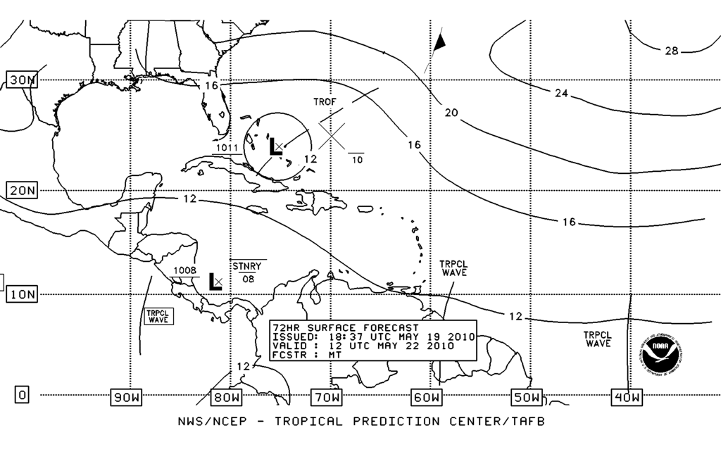
HPC has drawn in a closed surface low in the western Caribbean early next week. The attached graphic shows the low, however an ill placed NOAA logo sits smack dab in the middle of the that low...

WXDATA, this is a little early huh? please tell me no threat.... I'm not done getting all my supplies together!
For now, any development should stay in the Caribbean or move northeastward.kayci wrote:WXDATA, this is a little early huh? please tell me no threat.... I'm not done getting all my supplies together!
-
wxman57

- Global Moderator

- Posts: 2621
- Joined: Thu Feb 04, 2010 5:34 am
- Location: Southwest Houston (Westbury)
- Contact:
A strong westerly jet stream blowing across the Gulf for the next few weeks will keep the Gulf free of storms. If anything was to develop in the Caribbean it won't come this way. However, I think the models are making their usual errors of developing something down there this time of year. If you remember, 2 weeks ago they were insistent of a big storm developing in the SW Caribbean last week. Then the development moved to early this week, then late this week, then early next week, now late next week. It's all bogus lows. Sure, eventually the models will be right, but probably not now.
-
srainhoutx
- Site Admin
- Posts: 19616
- Joined: Tue Feb 02, 2010 2:32 pm
- Location: Maggie Valley, NC
- Contact:
Carla/Alicia/Jerry(In The Eye)/Michelle/Charley/Ivan/Dennis/Katrina/Rita/Wilma/Humberto/Ike/Harvey
Member: National Weather Association
Facebook.com/Weather Infinity
Twitter @WeatherInfinity
Member: National Weather Association
Facebook.com/Weather Infinity
Twitter @WeatherInfinity
I didn't know where to post this so please forgive me if this isn't the proper place, but I was wanting to know how can I find NOAA's outlook for the 2010 hurricane season, I read it was supposed to be out today. I looked on their website but didn't see it. Thank you.
My name is Nicole and I love weather!!
~~~~~~~~~~~~~~~~~~~~~~~~~~~~~~~~~~~~~~~~~~~~~~~~~~~~~~~~~~~~~~~~~~~~~~~~~~~~~~~~~~~~~~~~~~~~~~~~
Alicia, Allison, Rita, Ike
~~~~~~~~~~~~~~~~~~~~~~~~~~~~~~~~~~~~~~~~~~~~~~~~~~~~~~~~~~~~~~~~~~~~~~~~~~~~~~~~~~~~~~~~~~~~~~~~
Alicia, Allison, Rita, Ike
-
srainhoutx
- Site Admin
- Posts: 19616
- Joined: Tue Feb 02, 2010 2:32 pm
- Location: Maggie Valley, NC
- Contact:
That release was delayed until the 27th.rnmm wrote:I didn't know where to post this so please forgive me if this isn't the proper place, but I was wanting to know how can I find NOAA's outlook for the 2010 hurricane season, I read it was supposed to be out today. I looked on their website but didn't see it. Thank you.
Carla/Alicia/Jerry(In The Eye)/Michelle/Charley/Ivan/Dennis/Katrina/Rita/Wilma/Humberto/Ike/Harvey
Member: National Weather Association
Facebook.com/Weather Infinity
Twitter @WeatherInfinity
Member: National Weather Association
Facebook.com/Weather Infinity
Twitter @WeatherInfinity
-
srainhoutx
- Site Admin
- Posts: 19616
- Joined: Tue Feb 02, 2010 2:32 pm
- Location: Maggie Valley, NC
- Contact:
Certainly looks like some type of Hybrid system may try to form. The question is will this become our first Invest and perhaps the first named system by the NHC?
AREA FORECAST DISCUSSION
NATIONAL WEATHER SERVICE CHARLESTON SC
704 AM EDT FRI MAY 21 2010
.SYNOPSIS...
WEAK HIGH PRESSURE WILL REMAIN ACROSS THE EASTERN UNITED STATES
THROUGH THE WEEKEND. TROPICAL OR SUBTROPICAL LOW PRESSURE WILL
MOVE TOWARD THE SOUTHEAST COAST DURING THE EARLY AND MIDDLE
PORTION OF NEXT WEEK.
THE MAIN FEATURE IN QUESTION FOR LATE WEEKEND INTO EARLY NEXT WEEK
WILL BE A WAVE OF LOW PRESSURE DEVELOPING IN THE SOUTHWEST
ATLANTIC. ALTHOUGH MODELS CONTINUE TO DIFFER REGARDING DETAILS OF
THE EVENTUAL TRACK OF THIS SYSTEM...THE GENERAL PATTERN HAS BEEN
CONSISTENTLY DEPICTED IN MOST MID RANGE SOLUTIONS. MODELS SUGGEST
THAT THE LOW SYSTEM COULD INITIATE WITH TROPICAL CHARACTERISTICS
OVER THE WEEKEND. HOWEVER BY MONDAY...THE AFOREMENTIONED UPPER
TROUGH OVER THE NEW ENGLAND AND MID ATLANTIC STATES WILL EXPAND
INTO THE ATLANTIC AND LIKELY ENERGIZE THE SURFACE LOW DRIFTING
NORTHWARD FROM THE CARIBBEAN. AS A RESULT OF THE DYNAMIC SUPPORT
PROVIDED BY THE UPPER TROUGH...THE FEATURE COULD BECOME A HYBRID
SYSTEM WHILE TURNING WEST TOWARD THE CAROLINA COASTLINE.
SENSIBLE WEATHER IMPACTS...SUCH AS RAIN POTENTIAL AND WINDS...WILL
BE HIGHLY DEPENDENT ON THE TRACK OF THE LOW SYSTEM. SINCE MODELS ARE
STILL STRUGGLING TO COME TO A CONSENSUS THIS FAR IN ADVANCE...HAVE
MADE ONLY SLIGHT ADJUSTMENTS TO THE ONGOING FORECAST AND REMAIN
GENERIC REGARDING POPS INTO EARLY NEXT WEEK. HAVE THUS KEPT
SHOWER/THUNDERSTORM PROBABILITIES IN THE CHANCE RANGE FOR MONDAY
AFTERNOON...WITH THICKER CLOUD COVER SUPPORTING HIGH TEMPERATURES IN
THE LOW TO MID 80S.
Carla/Alicia/Jerry(In The Eye)/Michelle/Charley/Ivan/Dennis/Katrina/Rita/Wilma/Humberto/Ike/Harvey
Member: National Weather Association
Facebook.com/Weather Infinity
Twitter @WeatherInfinity
Member: National Weather Association
Facebook.com/Weather Infinity
Twitter @WeatherInfinity
-
wxman57
- Global Moderator
- Posts: 2621
- Joined: Thu Feb 04, 2010 5:34 am
- Location: Southwest Houston (Westbury)
- Contact:
The May ECMWF seasonal maps have been released. Compare the 2009 and 2010 pressure anomaly maps for August-October. I can't imagine more of a reversal from 2009. Same with the rain maps. With each month, the EC keeps forecasting lower and lower pressures in the tropics.
2009 Aug-Oct Pressure Anomaly:

2010 Aug-Oct Pressure Anomaly:

2009 Aug-Oct Rainfall:

2010 Aug-Oct Rainfall:

For comparison, the July 2008 Aug-Oct pressure anomaly. Note that we had very low pressures in the Atlantic for Ike and Gustav - BUT the pressures in the Pacific were not very high. That's a big difference which could significantly enhance 2010 over 2008:

2009 Aug-Oct Pressure Anomaly:
2010 Aug-Oct Pressure Anomaly:
2009 Aug-Oct Rainfall:
2010 Aug-Oct Rainfall:
For comparison, the July 2008 Aug-Oct pressure anomaly. Note that we had very low pressures in the Atlantic for Ike and Gustav - BUT the pressures in the Pacific were not very high. That's a big difference which could significantly enhance 2010 over 2008:
-
srainhoutx
- Site Admin
- Posts: 19616
- Joined: Tue Feb 02, 2010 2:32 pm
- Location: Maggie Valley, NC
- Contact:
Enjoy the rest while you can wxman57! 
Carla/Alicia/Jerry(In The Eye)/Michelle/Charley/Ivan/Dennis/Katrina/Rita/Wilma/Humberto/Ike/Harvey
Member: National Weather Association
Facebook.com/Weather Infinity
Twitter @WeatherInfinity
Member: National Weather Association
Facebook.com/Weather Infinity
Twitter @WeatherInfinity
-
srainhoutx
- Site Admin
- Posts: 19616
- Joined: Tue Feb 02, 2010 2:32 pm
- Location: Maggie Valley, NC
- Contact:
Getting to be that time of year...

Carla/Alicia/Jerry(In The Eye)/Michelle/Charley/Ivan/Dennis/Katrina/Rita/Wilma/Humberto/Ike/Harvey
Member: National Weather Association
Facebook.com/Weather Infinity
Twitter @WeatherInfinity
Member: National Weather Association
Facebook.com/Weather Infinity
Twitter @WeatherInfinity
the 18Z at 300hr shows a nice but rather large tropical storm sitting right over the oil spill.....nice...
la la land I know....
http://www.nco.ncep.noaa.gov/pmb/nwprod ... n_300l.gif
la la land I know....
http://www.nco.ncep.noaa.gov/pmb/nwprod ... n_300l.gif
288 GFS
interesting....that is purely tropical...
http://www.nco.ncep.noaa.gov/pmb/nwprod ... n_288l.gif
interesting....that is purely tropical...
http://www.nco.ncep.noaa.gov/pmb/nwprod ... n_288l.gif
06Z GFS 300hr
http://www.nco.ncep.noaa.gov/pmb/nwprod ... n_300l.gif
the 12z lost it.....if you track the distrubance it comes from the ITCZ...most likely the low currently out there off of Africa.
http://www.nco.ncep.noaa.gov/pmb/nwprod ... n_300l.gif
the 12z lost it.....if you track the distrubance it comes from the ITCZ...most likely the low currently out there off of Africa.