
February-Comfortable Days/Cool Nights To The Month
-
drmasommer
- Posts: 2
- Joined: Fri Feb 05, 2010 11:50 am
- Contact:
Please split the threads. The discussions should focus on the KHOU region unless the weather far to the north will have a critical and direct impact on the Houston region.
-
srainhoutx

- Site Admin

- Posts: 19616
- Joined: Tue Feb 02, 2010 2:32 pm
- Location: Maggie Valley, NC
- Contact:
With our current platform we can certainly accomplish what has been suggested. As we continue to grow and our membership and viewers of our weather community expands, we will never forget our 'roots' as a SE Texas based weather board that a Houston CBS affiliate television station funds and supports our efforts. We'll work on a solution that will provide the best of a ever growing Regional Weather Community as well as focus attention to our local weather as we do in providing Jeff's e-mail updates and major weather events that extend beyond our Region as we do in our Hurricane Central area as well as the in depth coverage of Super Storm Sandy. With growth comes some growing pains. And in the grand scheme of things, that is a positive problem not a negative. We have been working behind the scene for months to make improvements and upgrades for the expansion of what once was a little local weather community. Together we have built a weather board that we all can be proud of. Our weather community is now monitored by major media outlets from Coast to Coast. That is direct reflection on the quality of information from our knowledgeable members and the contributions our Pro Mets add that lends credibility to this great weather community. After all, we are one of the longest lasting weather boards on the web dating back to 2001.
Carla/Alicia/Jerry(In The Eye)/Michelle/Charley/Ivan/Dennis/Katrina/Rita/Wilma/Humberto/Ike/Harvey
Member: National Weather Association
Facebook.com/Weather Infinity
Twitter @WeatherInfinity
Member: National Weather Association
Facebook.com/Weather Infinity
Twitter @WeatherInfinity

To make it simple, just have one thread about weather outside of Houston that could cover discussion about north TX and all 49 other states and then the other just Houston locally. I don't want this forum to turn into a storm2k page. There is so many pages and topics each day it can drive me crazy. Just my two cents. But honestly, what we have going on now doesn't bother me.
Blake
Boomer Sooner
Boomer Sooner
line is starting to build west of the dfw area
http://wdssii.nssl.noaa.gov/web/wdss2/p ... loop.shtml
http://wdssii.nssl.noaa.gov/web/wdss2/p ... loop.shtml
-
srainhoutx
- Site Admin
- Posts: 19616
- Joined: Tue Feb 02, 2010 2:32 pm
- Location: Maggie Valley, NC
- Contact:
Looks like a Watch may be forthcoming for portions of Central Texas...unome wrote:line is starting to build west of the dfw area
http://wdssii.nssl.noaa.gov/web/wdss2/p ... loop.shtml
http://www.spc.noaa.gov/products/md/md0213.html
Carla/Alicia/Jerry(In The Eye)/Michelle/Charley/Ivan/Dennis/Katrina/Rita/Wilma/Humberto/Ike/Harvey
Member: National Weather Association
Facebook.com/Weather Infinity
Twitter @WeatherInfinity
Member: National Weather Association
Facebook.com/Weather Infinity
Twitter @WeatherInfinity
go to link for watch status reports http://www.spc.noaa.gov/products/watch/ww0039.html
SEL9
URGENT - IMMEDIATE BROADCAST REQUESTED
SEVERE THUNDERSTORM WATCH NUMBER 39
NWS STORM PREDICTION CENTER NORMAN OK
1035 PM CST SUN FEB 24 2013
THE NWS STORM PREDICTION CENTER HAS ISSUED A
SEVERE THUNDERSTORM WATCH FOR PORTIONS OF
NORTHWEST AND WEST-CENTRAL TEXAS
EFFECTIVE THIS SUNDAY NIGHT AND MONDAY MORNING FROM 1035 PM UNTIL
600 AM CST.
HAIL TO 1.5 INCHES IN DIAMETER...THUNDERSTORM WIND GUSTS TO 70
MPH...AND DANGEROUS LIGHTNING ARE POSSIBLE IN THESE AREAS.
THE SEVERE THUNDERSTORM WATCH AREA IS APPROXIMATELY ALONG AND 70
STATUTE MILES EAST AND WEST OF A LINE FROM 50 MILES SOUTH
SOUTHEAST OF SAN ANGELO TEXAS TO 80 MILES NORTH NORTHWEST OF
MINERAL WELLS TEXAS. FOR A COMPLETE DEPICTION OF THE WATCH SEE
THE ASSOCIATED WATCH OUTLINE UPDATE (WOUS64 KWNS WOU9).
REMEMBER...A SEVERE THUNDERSTORM WATCH MEANS CONDITIONS ARE
FAVORABLE FOR SEVERE THUNDERSTORMS IN AND CLOSE TO THE WATCH
AREA. PERSONS IN THESE AREAS SHOULD BE ON THE LOOKOUT FOR
THREATENING WEATHER CONDITIONS AND LISTEN FOR LATER STATEMENTS
AND POSSIBLE WARNINGS. SEVERE THUNDERSTORMS CAN AND OCCASIONALLY
DO PRODUCE TORNADOES.
DISCUSSION...TSTMS HAVE RECENTLY DEVELOPED NEAR THE INTERSECTION OF
A SWD-MOVING COLD FRONT AND AN EWD-MOVING PACIFIC FRONT OVER THE LOW
ROLLING PLAINS WITH ADDITIONAL STORM DEVELOPMENT ANTICIPATED SWD
ALONG THE PACIFIC FRONT INTO THE CONCHO VALLEY. A STRONG...SLY LLJ
WILL CONTINUE TO ADVECT AN INCREASINGLY MOIST BOUNDARY LAYER BENEATH
VERY STEEP MIDLEVEL LAPSE RATES /REFERENCE 00Z MAF SOUNDING/...
CONTRIBUTING TO MUCAPE VALUES APPROACHING 1000 J/KG WITHIN THE WARM
SECTOR. GIVEN THE STRONG FORCING FOR ASCENT AND VERTICAL SHEAR
ATTENDANT TO THE DEEP-LAYER CYCLONE MOVING INTO THE SRN PLAINS...THE
SETUP WILL PROMOTE SEVERE STORMS CAPABLE OF LARGE HAIL AND DAMAGING
WIND GUSTS.
AVIATION...A FEW SEVERE THUNDERSTORMS WITH HAIL SURFACE AND ALOFT
TO 1.5 INCHES. EXTREME TURBULENCE AND SURFACE WIND GUSTS TO 60
KNOTS. A FEW CUMULONIMBI WITH MAXIMUM TOPS TO 400. MEAN STORM
MOTION VECTOR 24035.
...MEAD
-
Paul Robison
Sorry for trolling, but I do want to know this:
Could tomorrow's expected near-40mph wind gusts produce damage similar to hurricane irene?
NOTE from the washington post:
As Hurricane Irene bears down on the region, the National Weather Service forecasts sustained winds of 30 to 40 mph in the District and the suburbs Saturday night into Sunday, with gusts up to 50 mph. Ocean City can expect much more bluster — sustained wind up to 90 mph and gusts even faster.
Just how much damage will all this blowing cause?
At 20 mph, trees will sway and leaves may strip off.
At 30 mph, dead branches can fall. If you’re daring — or dumb — enough to walk outside, prepare to grab one of those swaying trees to keep upright. Lawn furniture will blow around unless it’s heavy or well-secured.
But stuff doesn’t really start to fly until the wind blows even harder.
At 40 mph, branches start to rip off trees, even “well-secured branches,” said James B. Elsner, a geography professor at Florida State University who studies hurricanes.
Um, no. It will be a breezy day around here, but nothing that we haven't seen a couple of times each winter after a strong front.
-
Andrew
- Site Admin
- Posts: 3440
- Joined: Wed Feb 03, 2010 9:46 pm
- Location: North-West Houston
- Contact:
Nothing close to Irene will happen or anything to that intensity. Just some stronger than normal winds.Paul Robison wrote:Sorry for trolling, but I do want to know this:
Could tomorrow's expected near-40mph wind gusts produce damage similar to hurricane irene?
NOTE from the washington post:
As Hurricane Irene bears down on the region, the National Weather Service forecasts sustained winds of 30 to 40 mph in the District and the suburbs Saturday night into Sunday, with gusts up to 50 mph. Ocean City can expect much more bluster — sustained wind up to 90 mph and gusts even faster.
Just how much damage will all this blowing cause?
At 20 mph, trees will sway and leaves may strip off.
At 30 mph, dead branches can fall. If you’re daring — or dumb — enough to walk outside, prepare to grab one of those swaying trees to keep upright. Lawn furniture will blow around unless it’s heavy or well-secured.
But stuff doesn’t really start to fly until the wind blows even harder.
At 40 mph, branches start to rip off trees, even “well-secured branches,” said James B. Elsner, a geography professor at Florida State University who studies hurricanes.
For Your Infinite Source For All Things Weather Visit Our Facebook
And of course, the thin line of storms that looked encouraging about an hour ago has now fallen apart to nothing but sprinkles and continuing to lose its punch as it approaches central TX. Looks like we'll get dry slotted again Portastorm! 
Blake
Boomer Sooner
Boomer Sooner
-
Katdaddy

- Global Moderator

- Posts: 2502
- Joined: Thu Feb 04, 2010 8:18 am
- Location: League City, Tx
- Contact:
Strong cold front should be E of SE TX by noon. A few strong to possibly severe storms may develop late morning but the main story will be the winds this afternoon and evening:
URGENT - WEATHER MESSAGE
NATIONAL WEATHER SERVICE HOUSTON/GALVESTON TX
359 AM CST MON FEB 25 2013
...WIND ADVISORY REMAINS IN EFFECT FOR ALL OF SOUTHEAST TEXAS FROM
NOON TODAY TO 7 PM CST THIS EVENING...
.A COLD FRONT WILL PUSH THROUGH SOUTHEAST TEXAS THIS MORNING....AND
STRONG AND GUSTY WEST WINDS WILL DEVELOP THIS AFTERNOON UNDER A
TIGHTENING SURFACE PRESSURE GRADIENT. SUSTAINED WINDS OF 20 TO 30
MPH WITH GUSTS AROUND 40 MPH WILL BE POSSIBLE. THE WIND ADVISORY MIGHT
NEED TO BE EXTENDED LATER INTO THE EVENING FOR PORTIONS OF THE AREA.
TXZ163-164-176>179-195>200-210>214-226-227-235>238-260100-
/O.CON.KHGX.WI.Y.0003.130225T1800Z-130226T0100Z/
AUSTIN-BRAZORIA-BRAZOS-BURLESON-CHAMBERS-COLORADO-FORT BEND-
GALVESTON-GRIMES-HARRIS-HOUSTON-JACKSON-LIBERTY-MADISON-MATAGORDA-
MONTGOMERY-POLK-SAN JACINTO-TRINITY-WALKER-WALLER-WASHINGTON-
WHARTON-
INCLUDING THE CITIES OF...ALVIN...ANAHUAC...ANGLETON...BAY CITY...
BELLVILLE...BRENHAM...BROOKSHIRE...BRYAN...CALDWELL...CLEVELAND...
COLDSPRING...COLLEGE STATION...COLUMBUS...CONROE...CORRIGAN...
CROCKETT...DAYTON...EAGLE LAKE...EDNA...EL CAMPO...FREEPORT...
FRIENDSWOOD...GALVESTON...GROVETON...HEMPSTEAD...HOUSTON...
HUMBLE...HUNTSVILLE...KATY...LAKE JACKSON...LAKE SOMERVILLE...
LEAGUE CITY...LIBERTY...LIVINGSTON...MADISONVILLE...
MISSOURI CITY...MONT BELVIEU...NAVASOTA...ONALASKA...PALACIOS...
PASADENA...PEARLAND...PIERCE...PRAIRIE VIEW...RICHMOND...
ROSENBERG...SEALY...SHEPHERD...SUGAR LAND...TEXAS CITY...
THE WOODLANDS...TOMBALL...TRINITY...WEIMAR...WHARTON...WILLIS...
WINNIE
359 AM CST MON FEB 25 2013
...WIND ADVISORY REMAINS IN EFFECT FROM NOON TODAY TO 7 PM CST
THIS EVENING...
* EVENT...WEST WINDS 20 TO 30 MPH WITH GUSTS AROUND 40 MPH
* TIMING...NOON TO 7 PM CST THIS EVENING
* IMPACT...CROSS WINDS SHOULD MAKE DRIVING CONDITIONS DIFFICULT
AND POTENTIALLY DANGEROUS
PRECAUTIONARY/PREPAREDNESS ACTIONS...
DRIVERS OF VANS...CAMPERS...TRAILERS...AND OTHER HIGH-PROFILE VEHICLES
SHOULD BE ALERT TO THE DANGER OF THESE WINDS...ESPECIALLY WHEN DRIVING
ALONG NORTH TO SOUTH ORIENTED ROADS.
-
srainhoutx
- Site Admin
- Posts: 19616
- Joined: Tue Feb 02, 2010 2:32 pm
- Location: Maggie Valley, NC
- Contact:
Panhandle Blizzard Update:
Thunder snow with 2-3 inch per hour snow fall rates continue from Lubbock to Amarillo. The storm system continues to deepen with 3-5mb per hour pressure drops as the U/L slowly moves generally E from SW of Lubbock. The guidance did well suggesting a more Southern track but missed the trowal by suggesting that feature would be further E. Travel is virtually impossible across most of the Panhandle and most plowing operations have ceased. Snow totals of 2ft+ are likely with some isolated totals near 3 feet. Winds are gusting in to 60 to 70 mph range across many locations. Snow drifts will likely end up in near historic for the Panhandle. Closer to home a skinny line of showers and isolated storms are moving E into the Western zones of SE TX. The main story will be the very gusty winds later today as the storm to our N and W continues to intensify and track near Sherman in N Texas tonight.

Thunder snow with 2-3 inch per hour snow fall rates continue from Lubbock to Amarillo. The storm system continues to deepen with 3-5mb per hour pressure drops as the U/L slowly moves generally E from SW of Lubbock. The guidance did well suggesting a more Southern track but missed the trowal by suggesting that feature would be further E. Travel is virtually impossible across most of the Panhandle and most plowing operations have ceased. Snow totals of 2ft+ are likely with some isolated totals near 3 feet. Winds are gusting in to 60 to 70 mph range across many locations. Snow drifts will likely end up in near historic for the Panhandle. Closer to home a skinny line of showers and isolated storms are moving E into the Western zones of SE TX. The main story will be the very gusty winds later today as the storm to our N and W continues to intensify and track near Sherman in N Texas tonight.
Carla/Alicia/Jerry(In The Eye)/Michelle/Charley/Ivan/Dennis/Katrina/Rita/Wilma/Humberto/Ike/Harvey
Member: National Weather Association
Facebook.com/Weather Infinity
Twitter @WeatherInfinity
Member: National Weather Association
Facebook.com/Weather Infinity
Twitter @WeatherInfinity
-
srainhoutx
- Site Admin
- Posts: 19616
- Joined: Tue Feb 02, 2010 2:32 pm
- Location: Maggie Valley, NC
- Contact:
Morning e-mail from Jeff:
A powerful winter storm over the central plains this morning with bring a strong cold frontal passage to the area over the next few hours.
Strong cold front is currently plowing through central TX and is nearing our western counties early this morning as a full scale blizzard is in progress over the TX panhandle into Oklahoma and Kansas. Main surface low over NW TX will deepen today blasting the cold front through the area by late morning. Strong forcing along the front should generate a thin line of showers and thunderstorms which will move rapidly west to east across the area. Instability and less capping east of I-45 will support a marginal severe threat with strong winds being the primary concern.
Deepening surface low will result in a very tight pressure gradient across the region by early afternoon with WNW winds increasing to 20-30mph with frequent gust to 40-45mph. A wind advisory is in effect starting at noon and will continue into the early evening hours. Winds of this magnitude may cause tree limbs to fall on power lines and down dead trees from the 2011 drought.
Other item this afternoon will be fire weather as strong winds couple with very dry air to produce critical fire weather conditions. A Red Flag Warning is in effect for this afternoon for all counties, but feel the highest fire danger will be along and west of a line from College Station to Wharton where rainfall over the past several weeks has been lower compared to locations near the coast and E of I-45. With such strong winds expected, any fire that develops will burn quickly out of control.
After today mainly clear and cool weather for the rest of the week. Another cool front will move across the region on Thursday, but little moisture will mean generally no rainfall. This front will bring a bout of colder weather for Friday-weekend with lows into the low to mid 30’s and highs in the 50’s to near 60.
Carla/Alicia/Jerry(In The Eye)/Michelle/Charley/Ivan/Dennis/Katrina/Rita/Wilma/Humberto/Ike/Harvey
Member: National Weather Association
Facebook.com/Weather Infinity
Twitter @WeatherInfinity
Member: National Weather Association
Facebook.com/Weather Infinity
Twitter @WeatherInfinity
-
srainhoutx
- Site Admin
- Posts: 19616
- Joined: Tue Feb 02, 2010 2:32 pm
- Location: Maggie Valley, NC
- Contact:
A couple of early morning TX DOT webcam shots from just N of Lubbock and Amarillo:
- 02252013 745AM Hale Center I27 Lubbock TMCE9%20CCTV%20Pump%20Station_LBB.jpg (7.6 KiB) Viewed 3488 times
- 02252013 Amarillo 745AM TX DOT I40%20-%20Bell_AMA.jpg (5.47 KiB) Viewed 3488 times
Carla/Alicia/Jerry(In The Eye)/Michelle/Charley/Ivan/Dennis/Katrina/Rita/Wilma/Humberto/Ike/Harvey
Member: National Weather Association
Facebook.com/Weather Infinity
Twitter @WeatherInfinity
Member: National Weather Association
Facebook.com/Weather Infinity
Twitter @WeatherInfinity
-
wxman57

- Global Moderator
- Posts: 2621
- Joined: Thu Feb 04, 2010 5:34 am
- Location: Southwest Houston (Westbury)
- Contact:
Winds near 40 mph could be enough to produce spotty power outages across southeast Texas. Perhaps a few tree branches will fall on power lines, or the moving power lines could come into contact with nearby trees causing a few breakers to trip. No significant damage, though.Andrew wrote:Paul Robison wrote:Sorry for trolling, but I do want to know this:
Could tomorrow's expected near-40mph wind gusts produce damage similar to hurricane irene?
...snip...
I see the wind is going to blow about as hard as the forecasts do lately. Severe storms and rain coming...oh wait sprinkles, and not any colder. The last 2 "winters" have been depressing.
as of 9:01 CenterPoint reports 1238 customers without power - that's up from 700-something around 7 am
unome wrote:power outages might be a concern with high winds
this site has links for all states http://vielmetti.typepad.com/vacuum/201 ... -maps.html
locally of course, here's centerpoint http://gis.centerpointenergy.com/outage ... index.html they even have a NexRad layer available for their map, but it's static
-
srainhoutx
- Site Admin
- Posts: 19616
- Joined: Tue Feb 02, 2010 2:32 pm
- Location: Maggie Valley, NC
- Contact:
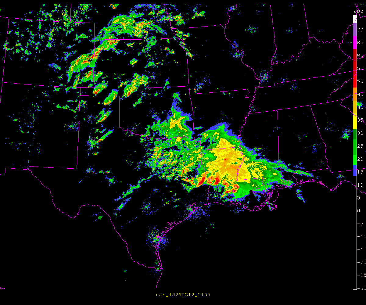
From a meteorological standpoint this is an awesome looking storm.
- Attachments
-
Carla/Alicia/Jerry(In The Eye)/Michelle/Charley/Ivan/Dennis/Katrina/Rita/Wilma/Humberto/Ike/Harvey
Member: National Weather Association
Facebook.com/Weather Infinity
Twitter @WeatherInfinity
Member: National Weather Association
Facebook.com/Weather Infinity
Twitter @WeatherInfinity
-
srainhoutx
- Site Admin
- Posts: 19616
- Joined: Tue Feb 02, 2010 2:32 pm
- Location: Maggie Valley, NC
- Contact:
MESOSCALE DISCUSSION 0219
NWS STORM PREDICTION CENTER NORMAN OK
0925 AM CST MON FEB 25 2013
AREAS AFFECTED...E TX INTO SRN AR/LA/SWRN MS
CONCERNING...SEVERE POTENTIAL...WATCH LIKELY
VALID 251525Z - 251630Z
PROBABILITY OF WATCH ISSUANCE...80 PERCENT
SUMMARY...HAIL POTENTIAL IS FORECAST TO INCREASE ACROSS THE
DISCUSSION AREA IN THE SHORT TERM...FOLLOWED BY AN INCREASE IN
DAMAGING WIND/ISOLATED TORNADO POTENTIAL LATER THIS MORNING/EARLY
AFTERNOON. WW WILL BECOME LIKELY IN THE NEXT 1-2 HOURS.
DISCUSSION...A VERY STRONG STORM SYSTEM IS ADVANCING EWD ACROSS NWRN
TX ATTM...WITH THE MID/UPPER LEVEL CENTER OF CIRCULATION INVOF CDS
/CHILDRESS TX/ AND THE SURFACE LOW NOW JUST N OF ABI /ABILENE TX/.
S OF THE SURFACE LOW...A PACIFIC COLD FRONT CONTINUES SURGING EWD
THROUGH E TX...WHILE THE WARM FRONT EXTENDS SEWD FROM THE LOW ACROSS
E TX TO THE VICINITY OF LCH /LAKE CHARLES LA/.
WITH ONLY A SLIVER OF LOW-LEVEL GULF AIR INLAND ATTM -- OVER THE
HOUSTON METRO AREA AND VICINITY...STRONG LARGE-SCALE ASCENT IS
FOCUSED ACROSS THE ARKLATEX REGION WHERE STEEP MID-LEVEL LAPSE RATES
RESIDE ATOP A SURFACE-BASED STABLE LAYER. SCATTERED STORMS ARE
ONGOING INVOF THIS AREA...AND SHOULD CONTINUE OVER THE NEXT SEVERAL
HOURS ALONG WITH ATTENDANT HAIL POTENTIAL.
WITH TIME...AS THE SURFACE LOW SHIFTS EWD ACROSS THE RED RIVER
VALLEY...NWD RETREAT OF THE WARM FRONT IS EXPECTED AHEAD OF THE
ADVANCING PACIFIC FRONT. WITH TIME...EXPECT THE NOW-STABLE LOWER
TROPOSPHERE OVER LA TO BE REPLACED BY A FAVORABLY MOIST BOUNDARY
LAYER -- AND GIVEN VEERING/STRENGTHENING FLOW WITH HEIGHT ACROSS THE
REGION...SHEAR SUPPORTIVE OF SUPERCELLS WILL RESULT IN INCREASING
POTENTIAL FOR SURFACE-BASED SEVERE WEATHER IN ADDITION TO THE
ONGOING HAIL THREAT. ALONG WITH DAMAGING WIND POTENTIAL --
PARTICULARLY IF A LINE OF STORMS EVOLVES ALONG THE PACIFIC
FRONT...ISOLATED TORNADOES APPEAR LIKELY WITH PRE-FRONTAL
SUPERCELLULAR CONVECTION.
..GOSS/CORFIDI.. 02/25/2013
ATTN...WFO...JAN...LIX...LZK...LCH...SHV...HGX...
- Attachments
-
Carla/Alicia/Jerry(In The Eye)/Michelle/Charley/Ivan/Dennis/Katrina/Rita/Wilma/Humberto/Ike/Harvey
Member: National Weather Association
Facebook.com/Weather Infinity
Twitter @WeatherInfinity
Member: National Weather Association
Facebook.com/Weather Infinity
Twitter @WeatherInfinity
-
- Information
-
Who is online
Users browsing this forum: Ahrefs [Bot], Bing [Bot], TexasBreeze and 66 guests