
The next reliable model run will be the 00z gfs in about 30-45 minutesAlvin Girl wrote:biggerbyte wrote:Folks, there is going to be plenty of fuel over the western Carribean and Gulf of Mexico. Starting with the former, we need to watch for the possibility of rapid intensification. The big question beyond there is if, or when and where a weakness to its north develops and gives Ernesto a little more northward tug. The entire gulf region should be paying close attention at this point.
Edit to add that conditions other than warm waters have to be favorable. We will just have to see how things stack up over the coming days.
Agreed - I know I'll be glued to the forum over the next few days. I too have a "bad feeling" about the storm. Any new information or model runs in yet?
Ernesto Dissipates Over Mexico
-
Andrew
- Site Admin

- Posts: 3440
- Joined: Wed Feb 03, 2010 9:46 pm
- Location: North-West Houston
- Contact:
For Your Infinite Source For All Things Weather Visit Our Facebook
-
Andrew
- Site Admin
- Posts: 3440
- Joined: Wed Feb 03, 2010 9:46 pm
- Location: North-West Houston
- Contact:
GFS suggest stronger ridging through the whole period which translates into a middle Mexico landfall. Ridging looks extremely strong during the beginning of the run so I think there is about a 50-50 chance (according to the gfs) that this runs into south america.
For Your Infinite Source For All Things Weather Visit Our Facebook
-
srainhoutx

- Site Admin
- Posts: 19616
- Joined: Tue Feb 02, 2010 2:32 pm
- Location: Maggie Valley, NC
- Contact:
00Z GFS Ensembles = S Texas
Carla/Alicia/Jerry(In The Eye)/Michelle/Charley/Ivan/Dennis/Katrina/Rita/Wilma/Humberto/Ike/Harvey
Member: National Weather Association
Facebook.com/Weather Infinity
Twitter @WeatherInfinity
Member: National Weather Association
Facebook.com/Weather Infinity
Twitter @WeatherInfinity

My hunch is the High Pressure will definitely win out and be a South TX or upper to middle Mexico coast landfall by next weekend. Plus, why would you want a possible Cat 3-4 to come here anyway? IKE was enough for a while... AND all of SE and East TX is out of the drought area, it's not like we "desperately" need the rain. Give it to the folks in South TX who are in a drought and hope Ernesto can pull northward into Central and West TX where they REALLY need the rain. IF that were to play out, we would still be on the 'dirty' side and would see a huge surge of Gulf moisture.
Just my two cents. Bottom line though, WAY to early to determine where this storm will make landfall. Won't have a better handle on the possible landfall location till the earliest Sunday. But I would really give it till Monday into Tuesday to have a better idea.
I'm more interested in the wave behind Ernesto that has a "10% chance of development". As of 3am, looks pretty healthy. Sure signs that the Atlantic is heating up as the MJO is positive right now and the Atlantic High looks to be breaking down, thus, allow the dust off of Africa to slow down and produce a more favorable environment for storms coming off the African coast.
Blake
Boomer Sooner
Boomer Sooner
-
srainhoutx
- Site Admin
- Posts: 19616
- Joined: Tue Feb 02, 2010 2:32 pm
- Location: Maggie Valley, NC
- Contact:
Forecaster Roth of the HPC this morning regarding the potential future of Ernesto:
THE BIGGEST ISSUE/PROBLEM THIS FORECAST PERIOD IS ERNESTO...WHICH
THE 12Z GLOBAL ENSEMBLE GUIDANCE WANTS TO TAKE THROUGH BELIZE/THE
YUCATAN PENINSULA INTO THE BAY OF CAMPECHE...WHICH IS A BIT
SOUTHWEST OF THE NHC TRACK...WHICH MID PERIOD IS CLOSEST TO THE
00Z CANADIAN MODEL THAT ULTIMATELY TAKES THE STORM TOWARDS THE
UPPER TEXAS COAST. THE CONFIGURATION OF THE RIDGE OUT WEST AND A
PRECEDING UPPER LEVEL LOW COULD LURE ERNESTO UP TOWARDS THE 30TH
PARALLEL...BUT THAT ASSUMES A SYSTEM OF HURRICANE STRENGTH WHICH
IS MINIMALLY SHEARED. COMPROMISES WERE MADE BETWEEN THE ENSEMBLE
CLUSTERING AND THE CANADIAN MODEL...WITH SOME INPUT GATHERED FROM
NHC ON THE 08Z CONFERENCE CALL WHICH CAUSED SOME SLIGHT SLOWING.
FOR NOW...ITS PRESSURE HAS BEEN DRAWN DOWN BELOW 1000 HPA TO
INDICATE A SYSTEM OF HURRICANE STRENGTH...BUT ITS FUTURE DEPENDS
ON WHETHER OR NOT IT CAN EFFECTIVELY FIGHT THE VERTICAL WIND SHEAR
THAT THE LOW LEVEL JET STEERING THE SYSTEM QUICKLY WESTWARD
IMPARTS ON THE CYCLONE DURING THE NEXT COUPLE DAYS. STAY TUNED TO
THE LATEST ADVISORIES FROM NHC CONCERNING ERNESTO.
Carla/Alicia/Jerry(In The Eye)/Michelle/Charley/Ivan/Dennis/Katrina/Rita/Wilma/Humberto/Ike/Harvey
Member: National Weather Association
Facebook.com/Weather Infinity
Twitter @WeatherInfinity
Member: National Weather Association
Facebook.com/Weather Infinity
Twitter @WeatherInfinity
-
srainhoutx
- Site Admin
- Posts: 19616
- Joined: Tue Feb 02, 2010 2:32 pm
- Location: Maggie Valley, NC
- Contact:
06Z HWRF and GFDL...
- Attachments
-
-
Carla/Alicia/Jerry(In The Eye)/Michelle/Charley/Ivan/Dennis/Katrina/Rita/Wilma/Humberto/Ike/Harvey
Member: National Weather Association
Facebook.com/Weather Infinity
Twitter @WeatherInfinity
Member: National Weather Association
Facebook.com/Weather Infinity
Twitter @WeatherInfinity
-
srainhoutx
- Site Admin
- Posts: 19616
- Joined: Tue Feb 02, 2010 2:32 pm
- Location: Maggie Valley, NC
- Contact:
Morning e-mail from Jeff:
Tropical storm passing through the Windward Island with strong winds.
Discussion:
Ernesto moving through the Windward Islands. Winds gusted to 63mph at St Lucia and sustained winds of 43mph at Barbados in the last few hours. Ernesto is racing westward at 24mph this morning…very fast for a tropical cyclone…and the result in a disorganized system even though some strong winds are being reported on the islands. First few visible images this morning show a sheared system with an exposed low level center to the west of a small and decreasing ball of deep convection. The fast forward motion of the low level center is pushing the center out from under the deep convection and the net result is about 20kts of shear over the system. While the system is well defined on radar, it is not well organized and will have to slow its fast forward motion. It is possible that Ernesto may open up into a tropical wave over the next 24 hours.
Track:
Ernesto remains to the south of a very strong mid Atlantic ridge resulting in the fast forward motion, and this should continue for the next 1-2 days taking the system generally W to WNW through the eastern and central Caribbean Sea. BY the end of day 3 (Sunday) the system will begin to approach the western edge of the sub-tropical high over the SW Atlantic and start to encounter a weakness over the Gulf of Mexico. This weakness which is currently over the SE US will be moving westward this week as the TX high pressure cell builds/moves westward. The GFS and EURO take a weak system into the southern Yucatan and then MX while the CMC, UKMET, GFDL, and HWRF all show Ernesto turning NW into the weakness. The reasoning for the spilt in the guidance at the longer range is the intensity of the system. A weaker system will follow the low level flow and stay southward, while a stronger system feels the weakness in the ridge and begins to bend WNW and then NW. Current NHC track is pretty much down the middle road of the guidance with the GFS and EURO on the left and the GFDL and HWRF on the right. The track forecast for the next 48 hours is fairly high confidence, but the confidence lowers after 48 hours as the guidance spread becomes increasingly large.
Intensity:
The intensity forecast remains a problem as the near term environment is marginally favorable for development and the long term environment favorable. The question is does Ernesto survive the short term to take advantage of the long term. Based on the satellite presentation this morning it is questionable if Ernesto will survive the next 24 hours as the fast westward motion will continue to produce moderate to strong wind shear. Additionally, the eastern Caribbean Sea is typically not a very favorable region for developing tropical systems. Also the GFS and EURO continue to insist that the system will not intensify much, while the latest GFDL, HWRF, and CMC all show Ernesto reaching hurricane intensity in the western Caribbean Sea. Current NHC forecast is leaning toward the stronger guidance and takes Ernesto to a hurricane south of Jamaica and into the NE Yucatan and the SE Gulf of Mexico. It should be noted that conditions will be fairly favorable in the western Caribbean Sea and the LGEM and GFDI guidance makes Ernesto a major hurricane. It is also noted that most of the guidance makes Ernesto a category 2 hurricane about 48 hours prior to the official NHC forecast.
Now would be a good time for residents to review their hurricane preparation plans!
90L:
New tropical wave/surface low south of the Cape Verde Islands has developed some organized thunderstorms and continues to show signs of development this morning. NHC gives this system a 30% chance of tropical cyclone formation as it moves WNW at 10-15mph.
Forecast Model Tracks:
Carla/Alicia/Jerry(In The Eye)/Michelle/Charley/Ivan/Dennis/Katrina/Rita/Wilma/Humberto/Ike/Harvey
Member: National Weather Association
Facebook.com/Weather Infinity
Twitter @WeatherInfinity
Member: National Weather Association
Facebook.com/Weather Infinity
Twitter @WeatherInfinity
-
srainhoutx
- Site Admin
- Posts: 19616
- Joined: Tue Feb 02, 2010 2:32 pm
- Location: Maggie Valley, NC
- Contact:
I know there is some chatter across the weather boards that Ernesto is not looking to well and may be degenerating to an open wave, but MIMIC and Microwave data suggest that Ernesto is maintaining a closed circulation center albeit devoid of deep convection...
- Attachments
-
Carla/Alicia/Jerry(In The Eye)/Michelle/Charley/Ivan/Dennis/Katrina/Rita/Wilma/Humberto/Ike/Harvey
Member: National Weather Association
Facebook.com/Weather Infinity
Twitter @WeatherInfinity
Member: National Weather Association
Facebook.com/Weather Infinity
Twitter @WeatherInfinity
-
Katdaddy

- Global Moderator

- Posts: 2502
- Joined: Thu Feb 04, 2010 8:18 am
- Location: League City, Tx
- Contact:
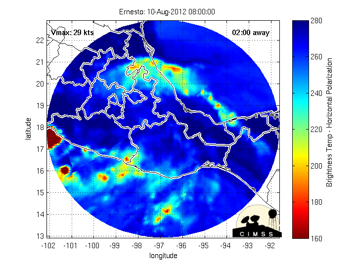
Ernesto is looking little better during the last few hours with a convective burst near the center. Lots of tropical cyclone watching through the weekend and into next week. The last major hurricane for the Upper TX Coast was Alicia 1983 which was 29 years ago. IKE was not a major. For the Middle TX Coast it has been 51 years.....Carla 1961.
-
srainhoutx
- Site Admin
- Posts: 19616
- Joined: Tue Feb 02, 2010 2:32 pm
- Location: Maggie Valley, NC
- Contact:
The 53rd RECON Group has a full plate and crews are being shifted as the Tropics become rather active including an area of disturbed weather off the Florida Coast enters the mix. Tis the season I suppose...
Code: Select all
WEATHER RECONNAISSANCE FLIGHTS
CARCAH, NATIONAL HURRICANE CENTER, MIAMI, FL.
1015 AM EDT FRI 03 AUGUST 2012
SUBJECT: TROPICAL CYCLONE PLAN OF THE DAY (TCPOD)
         VALID 04/1100Z TO 05/1100Z AUGUST 2012
         TCPOD NUMBER.....12-077

I. ATLANTIC REQUIREMENTS
    1. TROPICAL STORM ERNESTO
       FLIGHT ONE -TEAL 70-          FLIGHT TWO -TEAL 71-
       A. 04/1200, 1800Z             A. 05/0000Z, 0600Z
       B. AFXXX 0405A ERNESTO        B. AFXXX 0505A ERNESTO
       C. 04/1030Z                   C. 04/2200Z
       D. 14.4N 68.1W                D. 15.0N 71.2W
       E. 04/1130Z TO 04/1800Z       E. 04/2330Z TO 05/0600Z
       F. SFC TO 10,000 FT           F. SFC TO 10,000 FT

    2. OUTLOOK FOR SUCCEEDING DAY: CONTINUE 6-HRLY FIXES.
    3. REMARKS: BECAUSE OF THE STORM'S LOCATION AND FOR MORE
       FAVORABLE CREW SEQUENCING, TODAY'S FIX FOR 03/1800Z
       HAS BEEN SLIPPED TO 03/2200Z AND THE 04/0600Z
       REQUIREMENT HAS BEEN CANCELED.

    4. SUSPECT AREA (OFF EAST COAST OF FLORIDA)
       FLIGHT ONE -TEAL 73-
       A. 04/1900Z
       B. AFXXX 01BBA INVEST
       C. 04/1700Z
       D. 28.0N 80.0W
       E. 04/1830Z TO 04/2130Z
       F. SFC TO 10,000 FT

    5. SUCCEEDING DAY OUTLOOK.....NEGATIVE.
- Attachments
-
Carla/Alicia/Jerry(In The Eye)/Michelle/Charley/Ivan/Dennis/Katrina/Rita/Wilma/Humberto/Ike/Harvey
Member: National Weather Association
Facebook.com/Weather Infinity
Twitter @WeatherInfinity
Member: National Weather Association
Facebook.com/Weather Infinity
Twitter @WeatherInfinity
-
srainhoutx
- Site Admin
- Posts: 19616
- Joined: Tue Feb 02, 2010 2:32 pm
- Location: Maggie Valley, NC
- Contact:
12Z Tracks & Intensity:
- Attachments
-
-
Carla/Alicia/Jerry(In The Eye)/Michelle/Charley/Ivan/Dennis/Katrina/Rita/Wilma/Humberto/Ike/Harvey
Member: National Weather Association
Facebook.com/Weather Infinity
Twitter @WeatherInfinity
Member: National Weather Association
Facebook.com/Weather Infinity
Twitter @WeatherInfinity
-
srainhoutx
- Site Admin
- Posts: 19616
- Joined: Tue Feb 02, 2010 2:32 pm
- Location: Maggie Valley, NC
- Contact:
TROPICAL STORM ERNESTO DISCUSSION NUMBER 8
NWS NATIONAL HURRICANE CENTER MIAMI FL AL052012
1100 AM AST FRI AUG 03 2012
DATA FROM A RECONNAISSANCE PLANE AND RADAR FROM MARTINIQUE SHOWED
THE SMALL BUT WELL-DEFINED CENTER OF ERNESTO MOVED WESTWARD JUST
SOUTH OF OR OVER ST. LUCIA EARLY THIS MORNING. BASED ON THE
AIRCRAFT AND SURFACE OBSERVATIONS...THE INITIAL INTENSITY IS SET AT
45 KNOTS. THESE WINDS ARE CONFINED TO A SMALL AREA NORTH OF THE
CENTER. FAST-MOVING TROPICAL CYCLONES TYPICALLY DO NOT STRENGTHEN
MUCH AND IN FACT...LATEST SATELLITE IMAGES INDICATE LITTLE CHANGE
IN THE STRUCTURE OF THE CYCLONE.
ERNESTO IS MOVING TOWARD THE WEST OR 275 DEGREES AT 18 KNOTS
EMBEDDED WITHIN A FAST EASTERLY FLOW SOUTH OF THE SUBTROPICAL
RIDGE. THIS STEERING PATTERN SHOULD KEEP THE CYCLONE ON A GENERAL
WESTWARD TRACK FOR THE NEXT 2 TO 3 DAYS. BY THE TIME ERNESTO
REACHES THE WESTERN CARIBBEAN...THE STEERING FLOW IS EXPECTED TO
WEAKEN AND ERNESTO IS FORECAST TO SLOW DOWN. THE COMBINATION OF LOW
SHEAR AND HIGH UPPER-OCEAN HEAT CONTENT IN THE WESTERN CARIBBEAN
SEA WOULD FAVOR SOME INTENSIFICATION...AND ERNESTO IS FORECAST TO
BECOME A HURRICANE IN THE NORTHWESTERN CARIBBEAN SEA. THE OFFICIAL
FORECAST FOLLOWS THE INTENSITY CONSENSUS...BUT ONE SHOULD NOTE THAT
BOTH THE SHIPS AND LGEM INTENSITY MODELS ARE FORECASTING A STRONGER
HURRICANE.
MOST OF THE TRACK GUIDANCE IS IN PRETTY GOOD AGREEMENT THAT ERNESTO
WILL BE RACING WESTWARD ACROSS THE EASTERN AND CENTRAL CARIBBEAN
DURING THE NEXT 2 TO 3 DAYS. AFTER THAT...TRACK MODELS DIVERGE
CONSIDERABLY AND SOME MODELS KEEP ERNESTO ON A MORE WESTWARD
TRACK...WHILE ANOTHER GROUP TURN THE CYCLONE MORE TO THE
NORTHWEST...DEPENDING UPON HOW THE MODELS DEPICT THE STRENGTH OF
RIDGE TO THE NORTH. NEVERTHELESS...ALL INDICATIONS ARE THAT ERNESTO
WILL BE MOVING ACROSS THE NORTHWESTERN CARIBBEAN SEA IN 4 TO 5
DAYS.
FORECAST POSITIONS AND MAX WINDS
INIT 03/1500Z 13.7N 62.3W 45 KT 50 MPH
12H 04/0000Z 13.9N 64.9W 45 KT 50 MPH
24H 04/1200Z 14.4N 68.1W 50 KT 60 MPH
36H 05/0000Z 15.0N 71.2W 55 KT 65 MPH
48H 05/1200Z 15.5N 74.5W 60 KT 70 MPH
72H 06/1200Z 17.0N 80.0W 65 KT 75 MPH
96H 07/1200Z 18.5N 83.5W 75 KT 85 MPH
120H 08/1200Z 20.5N 87.0W 80 KT 90 MPH
$$
FORECASTER AVILA
Carla/Alicia/Jerry(In The Eye)/Michelle/Charley/Ivan/Dennis/Katrina/Rita/Wilma/Humberto/Ike/Harvey
Member: National Weather Association
Facebook.com/Weather Infinity
Twitter @WeatherInfinity
Member: National Weather Association
Facebook.com/Weather Infinity
Twitter @WeatherInfinity
Wxman57 suggested in another forum that it is unlikely to be a TX threat - either south of us into MX or east of us. Just wanted to get some other opinions on this, is it really unlikely (based on high pressure) for a TX landfall? (Not questioning your expertise Wxman57, just looking to see what others think )

He also said this: "Of course, that all depends on both models predicting the position of the ridge to the NW of TX and the weakness over the central to NE Gulf."
In other words, this is still 6-7-8 days away and the models are subject to change in the next week.
In other words, this is still 6-7-8 days away and the models are subject to change in the next week.
Wherever Ernesto goes, I hope Texas residents are using the next 5 days to check their hurricane preparedness. Activity in the tropics is picking up right on cue.
-
biggerbyte
- Posts: 1142
- Joined: Thu Feb 04, 2010 12:15 am
- Location: Porter, Texas. (Montgomery County)
- Contact:
For so, so many reasons, I feel it would be a huge mistake to say likely, or unlikely at this stage. Way too many variables and possibilities. Also, let's not let our guard down because of how Ernesto looks right now either. This was expected. If he can survive to the other side of the Carribean, and then into the Gulf, look out. Not saying that any one scenario will play out, but this is not over yet for anyone in the Gulf region.
-
srainhoutx
- Site Admin
- Posts: 19616
- Joined: Tue Feb 02, 2010 2:32 pm
- Location: Maggie Valley, NC
- Contact:
Ed Mahmoud wrote:Looks like Canadian has joined the GFS and Euro as seeing the unfavorable environment for the next couple of days keeping this weak enough to avoid being pulled into the Gulf.
Actually the GFS and the Canadian stall Ernesto along the Mexican Gulf Coast before shifting it N to NNE. All that happens after truncation in the GFS, but there still remains a deep trough approaching over the Rockies that eventually picks up the storm. That said we are still a long way out in really knowing exactly what will happen and the guidance will tend not to do very well with the weakness expected in about 5-7 days across E Texas/Louisiana. Meanwhile we watch and wait.
- Attachments
-
Carla/Alicia/Jerry(In The Eye)/Michelle/Charley/Ivan/Dennis/Katrina/Rita/Wilma/Humberto/Ike/Harvey
Member: National Weather Association
Facebook.com/Weather Infinity
Twitter @WeatherInfinity
Member: National Weather Association
Facebook.com/Weather Infinity
Twitter @WeatherInfinity

GFDL and HWRF still trend north