
the dry air shows up well on this loop
http://www.ssd.noaa.gov/PS/TROP/TCFP/da ... _vapor.gif
too large to embed
Ernesto Dissipates Over Mexico
-
srainhoutx

- Site Admin

- Posts: 19616
- Joined: Tue Feb 02, 2010 2:32 pm
- Location: Maggie Valley, NC
- Contact:
The 00Z Track and Intensity guidance is converging on a Cozumel/Cancun solution while the Intensity guidance is creeping closer to a potential Major Hurricane Status. We will see.
Carla/Alicia/Jerry(In The Eye)/Michelle/Charley/Ivan/Dennis/Katrina/Rita/Wilma/Humberto/Ike/Harvey
Member: National Weather Association
Facebook.com/Weather Infinity
Twitter @WeatherInfinity
Member: National Weather Association
Facebook.com/Weather Infinity
Twitter @WeatherInfinity

Ernie's looking good.http://i131.photobucket.com/albums/p284 ... ab880e.jpg


Ernesto is looking really healthy tonight. I expect a 60mph storm here in a few minutes when we get the advisory. My biggest concern with this storm is the deep warm water in the NW Caribbean that Ernesto is going to go right over. I wouldn't call this a Wilma situation by any means, but it certainly needs to be watched very carefully as it could undergo some rapid intensification when it enters in the NW Caribbean.
Also, the low near Florida could be a huge player in where this storm goes ...which could mean bad news for us as it could draw Ernesto NW into the Central Gulf, then start moving WNW. We'll see...
Also, the low near Florida could be a huge player in where this storm goes ...which could mean bad news for us as it could draw Ernesto NW into the Central Gulf, then start moving WNW. We'll see...
Blake
Boomer Sooner
Boomer Sooner
Still a Tropical Storm with winds still at 50mph. Has slowed down a little bit at 18mph moving West.
Also, track is more northward, not good for us:
This raises my eyebrow in the discussion:
BASED ON THE PREMISE THAT ERNESTO WILL BE FAR
ENOUGH NORTH AND STRONG ENOUGH TO RESPOND TO THE WEAKNESS...THE
LATTER PART OF THE NEW FORECAST TRACK IS NUDGED A LITTLE TO THE
NORTH OF THE PREVIOUS FORECAST.
Also, track is more northward, not good for us:
This raises my eyebrow in the discussion:
BASED ON THE PREMISE THAT ERNESTO WILL BE FAR
ENOUGH NORTH AND STRONG ENOUGH TO RESPOND TO THE WEAKNESS...THE
LATTER PART OF THE NEW FORECAST TRACK IS NUDGED A LITTLE TO THE
NORTH OF THE PREVIOUS FORECAST.
Blake
Boomer Sooner
Boomer Sooner
That caught my attention, too.Belmer wrote:BASED ON THE PREMISE THAT ERNESTO WILL BE FAR
ENOUGH NORTH AND STRONG ENOUGH TO RESPOND TO THE WEAKNESS...THE
LATTER PART OF THE NEW FORECAST TRACK IS NUDGED A LITTLE TO THE
NORTH OF THE PREVIOUS FORECAST.

I haven't been this concerned about a storm since Ike.
jasons wrote:I haven't been this concerned about a storm since Ike.
I'm the same way. I mean, Ike concerned me terribly, but this storm I think has me more concerned. Why? Man, those waters in the NW Caribbean could really make this storm intensify into a Major Hurricane. Even though the forecast track only goes out five days, if you were to continue that track ...say seven days - the center would look to be in the Houston area. Also, IF this system decides to make a visit to the upper TX coast, the way it looks like right now, it will hit Friday night into early Saturday morning ....just like Ike.
This is going to be a LONG week. Not just because of this storm, but this is my last week of summer school here in San Marcos, and I have a HUGE final exam on Thursday morning. After the exam, I will be coming home back to Pasadena. ....Welcome home Blake. I've been gone for two months working my butt off, and I might be coming home to board up my windows. I see many sleepless nights ahead.
Blake
Boomer Sooner
Boomer Sooner
-
TexasBreeze
- Posts: 942
- Joined: Sun Sep 26, 2010 4:46 pm
- Location: NW Houston, TX
- Contact:
It sounds like with a weakness/trough developing in the eastern gulf and U.S. that it would end up being like the last gulf storm and be pulled up well east of TX. Wait and see.
Last edited by TexasBreeze on Fri Aug 03, 2012 10:25 pm, edited 1 time in total.
-
weatherguy425
- Pro Met

- Posts: 830
- Joined: Wed Feb 03, 2010 7:45 pm
- Location: Atlanta, Georgia
- Contact:
Belmer wrote:jasons wrote:I haven't been this concerned about a storm since Ike.
I'm the same way. I mean, Ike concerned me terribly, but this storm I think has me more concerned. Why? Man, those waters in the NW Caribbean could really make this storm intensify into a Major Hurricane. Even though the forecast track only goes out five days, if you were to continue that track ...say seven days - the center would look to be in the Houston area. Also, IF this system decides to make a visit to the upper TX coast, the way it looks like right now, it will hit Friday night into early Saturday morning ....just like Ike.
This is going to be a LONG week. Not just because of this storm, but this is my last week of summer school here in San Marcos, and I have a HUGE final exam on Thursday morning. After the exam, I will be coming home back to Pasadena. ....Welcome home Blake. I've been gone for two months working my butt off, and I might be coming home to board up my windows. I see many sleepless nights ahead.
Don't get me wrong;this is definitely a storm to watch. But I also think it has a chance to creep east of us as well. this weakness will be prevalent pretty much over the entire northern Gulf coast (unless Bermuda high edges westward which is possible) and the stronger it gets, the more poleward it would likely travel. Still a lot of time for things to evolve.
Putting a local perspective and some objectivity on any impacts to our neck of the woods in SE Texas...
Ernesto is so far out from having any real impacts on our region that most everyone should just be aware of the system but not be overly concerned about it. I know there are many here that probably lurk at some of the more active tropical sites and may get confused by what is being said or 'forecasted' by others. Many times the excitement of a system so far out with 'potential' will skew or mislead what will happen longer term with regards to the track, or how it is interpreted.
Ernesto is so far out from having any real impacts on our region that most everyone should just be aware of the system but not be overly concerned about it. I know there are many here that probably lurk at some of the more active tropical sites and may get confused by what is being said or 'forecasted' by others. Many times the excitement of a system so far out with 'potential' will skew or mislead what will happen longer term with regards to the track, or how it is interpreted.
-
Andrew
- Site Admin
- Posts: 3440
- Joined: Wed Feb 03, 2010 9:46 pm
- Location: North-West Houston
- Contact:
From this far out honestly I don't see this going east of Louisiana. While a weakness in the gulf does develop from the trough at the same time the ridging does develop back in very nicely and models have picked up on that with a push back to the west. We will see what the 00z models have to say.
For Your Infinite Source For All Things Weather Visit Our Facebook
-
cristina99

- Posts: 125
- Joined: Fri Jan 21, 2011 2:33 pm
- Location: The Woodlands / Spring / Conroe
- Contact:
I haven't posted in over a year. I usually just log on to read. Although I agree with those that have said it is good to be cautiously aware, it is quite daunting to look at the radar and guestimated track and see the storm as a CAT 1 heading towards Houston/Galveston. I still would use this time--whether this storm hits us or not-- to lock down any hurricane preparations (minus boarding up windows, etc.) Ike was bad enough and I remember going to the stores afterwards and standing in line just for ICE. It was scary. I am getting a Coleman light/lantern and a car charger for my iPhone (didn't have one last time and phone was useless after a day). Right now, if you look at it, it looks like something we do need to watch. Of course, my family and I start watching anything that gets in the vicinity of the Gulf. I find the information on this forum very much informative (nothing against the meterologists on TV, sometimes they just don't give as much info out) and will continue to do so through next week.
Bastardi brought up a good point...
@BigJoeBastardi
Convective blow up over Ernesto may be dry entrainment bursting, we will know tomorrow I have seen this many times, may not be what u think
Blake
Boomer Sooner
Boomer Sooner
-
Andrew
- Site Admin
- Posts: 3440
- Joined: Wed Feb 03, 2010 9:46 pm
- Location: North-West Houston
- Contact:
Belmer wrote:Bastardi brought up a good point...
@BigJoeBastardi
Convective blow up over Ernesto may be dry entrainment bursting, we will know tomorrow I have seen this many times, may not be what u think
I have to agree. At the same time though convection bursting to the east does look encouraging.
For Your Infinite Source For All Things Weather Visit Our Facebook

Appears that the UKMET has joined the EURO and GFS in the south camp.
-
Andrew
- Site Admin
- Posts: 3440
- Joined: Wed Feb 03, 2010 9:46 pm
- Location: North-West Houston
- Contact:
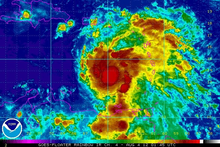
Nice banding starting to setup now. It is really looking good and the constant formation of convection would imply this is increased development. One thing to note though is a lot of the models are initializing poorly with the intensity of the storm currently. That could be one of the reasons why they are pushing Ernesto so far south and west. Tomorrow and Sunday will be key to see how much dry air and shear gets into the system. I don't think the system will get as weak as the GFS is describing but only time will tell.
http://www.ssd.noaa.gov/PS/TROP/floater ... -long.html
http://www.ssd.noaa.gov/PS/TROP/floater ... -long.html
For Your Infinite Source For All Things Weather Visit Our Facebook
Models are starting to agree with the GFS and EURO south solution
Not buying into that at the moment. This storm clearly is getting itself together and quickly! Not calling the Hurricane hunters liars by no means, but I just feel like Ernesto is not a 50mph storm. 60mph-65mph? Possibly. Since 11:00pm, Ernesto continues to get himself more defined. However, the reason I don't buy into the models going south into the Bay of Camp. and into Mexico, is because those models are still thinking that Ernesto will "weaken", thus allowing the trend to be southward. However, if Ernesto continues to strengthen, then my thinking is it should get picked up by the weakness in the Gulf come later in the week and allow it to be pulled NW/WNW. I would say as far East I see it going would be New Orleans ..and that's is pushing it.gocuse22 wrote:Models are starting to agree with the GFS and EURO south solution
Once models can lock on that Ernesto will infact not weaken, then those models might start shifting back north again.
EDIT TO ADD: With that said, I am throwing out the model runs as of right now, as none of them just seem to make sense to me. I expect a dramatic shift in models come 24 hours from now.
I am off to bed, have busy day tomorrow. Goodnight khou board.
Last edited by Belmer on Sat Aug 04, 2012 12:59 am, edited 2 times in total.
Blake
Boomer Sooner
Boomer Sooner
Belmer wrote:Not buying into that at the moment. This storm clearly is getting itself together and quickly! Not calling the Hurricane hunters liars by no means, but I just feel like Ernesto is not a 50mph storm. 60mph-65mph? Possibly. Since 11:00pm, Ernesto continues to get himself more defined. However, the reason I don't buy into the models going south into the Bay of Camp. and into Mexico, is because those models are still thinking that Ernesto will "weaken", thus allowing the trend to be southward. However, if Ernesto continues to strengthen, then my thinking is it should get picked up by the weakness in the Gulf come later in the week and allow it to be pulled NW/WNW. I would say as far East I see it going would be New Orleans ..and that's is pushing it.gocuse22 wrote:Models are starting to agree with the GFS and EURO south solution
Once models can lock on that Ernesto will infact not weaken, then those models might start shifting back north again.
Yeah i agree..Im shocked by these models shifting south...