

A passing upper disturbance will north of here, afternoon heating, a slightly unstable atmo, forming along and ahead of a cold front.Ptarmigan wrote:How did these thunderstorms form?
April Weather Discussion.
-
weatherguy425
- Pro Met

- Posts: 830
- Joined: Wed Feb 03, 2010 7:45 pm
- Location: Atlanta, Georgia
- Contact:
So what about those storms north of here?


Here is what I find strange. Storms fire in Central Texas, yet they are closer to Mexico than we are, which gives us the inversion cap we have over our area. I wonder how that could happen.wxdata wrote:
A passing upper disturbance will north of here, afternoon heating, a slightly unstable atmo, forming along and ahead of a cold front.
Afternoon heating was just enough to overcome cap, which wasn't as strong as last Friday.Ptarmigan wrote: Here is what I find strange. Storms fire in Central Texas, yet they are closer to Mexico than we are, which gives us the inversion cap we have over our area. I wonder how that could happen.
I am hearing some rain falling. Good to see some rain for a change. 


Interesting line of showers heading toward Houston from the North ( at 1:55am)
Soundings from both the 18z GFS and NAM both show a mostly unstable atmo for Friday afternoon. However the one big difference between the two model is the cap. GFS has a fairly decent one while the NAM has none. The persistence forecasting method would sure favor the GFS.
Ditto to my above msg on the 0z runs, with perhaps a bit less cap coming in on the GFS. Only thing lacking is a good surface trigger here until maybe Sunday (if the GFS is to believed.)
SPC placing SE TX in 'slight risk' for Friday, although once again we're on the southern edge of the risk area...
"...SRN PLAINS THROUGH LOWER MS VALLEY...
A MOIST WARM SECTOR WITH RICH GULF MOISTURE WILL ADVECT NWD THROUGH
THE ERN PORTIONS OF THE SRN PLAINS AND THE LOWER MS VALLEY FRIDAY
BENEATH A MODEST EML PLUME RESULTING IN MODERATE INSTABILITY. MODEL
SOLUTIONS CONTINUE TO DEVELOP CONVECTION WITHIN LOW-LEVEL THETA-E
ADVECTION REGIME IN WARM SECTOR. DETAILS OF HOW STORMS WILL INITIATE
AND EVOLVE REMAIN UNCERTAIN AT THIS POINT...BUT SEVERAL MODES OF
CONVECTION APPEAR LIKELY INCLUDING DISCRETE STORMS AND CLUSTERS.
LARGE HODOGRAPHS ALONG THE LOW LEVEL JET AXIS AND 40-50 KT DEEP
LAYER SHEAR WILL SUPPORT A THREAT OF SUPERCELLS AND TORNADOES AS
WELL AS LARGE HAIL AND DAMAGING WIND. OTHER STORMS WILL LIKELY
DEVELOP ALONG SEWD ADVANCING COLD FRONT. THIS AREA WILL CONTINUE TO
BE MONITORED FOR A POSSIBLE MODERATE RISK IN LATER OUTLOOKS."
http://www.spc.noaa.gov/products/outloo ... 0_prt.html
-
srainhoutx

- Site Admin

- Posts: 19616
- Joined: Tue Feb 02, 2010 2:32 pm
- Location: Maggie Valley, NC
- Contact:
HGX suggests that capping will likey be an issue. We shall see...
Carla/Alicia/Jerry(In The Eye)/Michelle/Charley/Ivan/Dennis/Katrina/Rita/Wilma/Humberto/Ike/Harvey
Member: National Weather Association
Facebook.com/Weather Infinity
Twitter @WeatherInfinity
Member: National Weather Association
Facebook.com/Weather Infinity
Twitter @WeatherInfinity
12z NAM continues to show marginal conditions for severe weather here Friday. Cape (red line) tops at around 1750 ('moderate') and Total Totals (blue line) tops around 50 (scattered thunderstorms, some possibly severe.) Of course we still have our old friend, The Cap, to deal with again too.
The cockroach cap is still at it.wxdata wrote:12z NAM continues to show marginal conditions for severe weather here Friday. Cape (red line) tops at around 1750 ('moderate') and Total Totals (blue line) tops around 50 (scattered thunderstorms, some possibly severe.) Of course we still have our old friend, The Cap, to deal with again too.
Might as well get a bunch of RAID cans and spray it on the cockroach cap.Ed Mahmoud wrote: The 0Z NAM says no dice on Friday.
Sim radar shows a few cells trying to pop in NE Texas, and NAM soundings looks decent for severe around Longview. Still a warm nose around 700 mb, but not as strong, and looks like daytime heating might be just enough.


GFS is pretty much in line with the NAM in regards to capping. Even with a LI of -7.2°, cloud cover will keep severe chances slim at KIAH. However the GFS is coming in much wetter for the weekend than the NAM. SPC is pretty much in agreement with now keeping Houston on the extreme southern edge of the slight risk area.
-
biggerbyte
- Posts: 1142
- Joined: Thu Feb 04, 2010 12:15 am
- Location: Porter, Texas. (Montgomery County)
- Contact:
Unlike last weekend, I see little hope of this cap breaking down. Now watch it pour down rain. Lol
It could start to get dry at someone's house besides Ed.
It could start to get dry at someone's house besides Ed.
-
srainhoutx
- Site Admin
- Posts: 19616
- Joined: Tue Feb 02, 2010 2:32 pm
- Location: Maggie Valley, NC
- Contact:
Capping will be the issue "locally tomorrow". But as we head into May and wxdata's thread, perhaps a better chance of some rain and hotter temps. Right on schedule...
AREA FORECAST DISCUSSION
NATIONAL WEATHER SERVICE HOUSTON/GALVESTON TX
356 PM CDT THU APR 29 2010
.DISCUSSION...
TIGHT PRESSURE GRADIENT RESULTING IN GUSTY SOUTH TO SOUTHEAST
WINDS ACROSS THE AREA THIS AFTN. LOW LEVEL MOISTURE IS GRADUALLY
INCREASING WITH PWS NOW AROUND AN INCH AND SFC DEWPOINTS IN THE
60S. 50 KNOT LOW LEVEL JET WILL PERSIST OVERNIGHT INTO FRIDAY
TRANSPORTING EVEN DEEPER MOISTURE INTO THE AREA. THE COMBINATION
OF WARM ADVECTION AND THE DEEPENING MOISTURE WILL LIKELY RESULT IN
DEVELOPMENT OF LIGHT SHOWERS BEGINNING LATE TONIGHT/EARLY FRIDAY
MORNING. EXTENSIVE STRATUS DEVELOPMENT IS EXPECTED OVERNIGHT INTO
FRIDAY MORNING WITH BREEZY CONDITIONS CONTINUING. PWS ARE
FORECAST TO INCREASE TO 1.4-1.6 INCHES BY MIDDAY FRIDAY. AS SFC
TEMPS WARM INTO THE 80S...THE ATMOSPHERE WILL BECOME MODERATELY
UNSTABLE FRIDAY AFTERNOON WITH CAPES OF 1500-2500 J/KG EXPECTED.
HOWEVER...GFS BUFR SOUNDINGS SHOW A STRONG CAP AROUND 800 MB WHICH
WILL BE DIFFICULT TO ERODE GIVEN THE LACK OF ANY SFC BOUNDARY IN
THE AREA. BEST CHANCE OF CAP ERODING WILL BE OVER THE NORTHERN
THIRD FRIDAY AFTERNOON. GFS SHOWS UPPER FLOW BECOMING MORE
DIFFLUENT FRIDAY AS 120 KT JET MAX APPROACHES FROM THE WEST. A
WEAK DISTURBANCE WILL PASS THROUGH CENTRAL/EAST TEXAS AS WELL.
EXPECT TSRA TO DEVELOP TO OUR NORTH FRI AFTN WITH OUR NRN ZONES
BEING ON THE TAIL END OF THIS. ANY STORMS THAT MANAGE TO BREAK THE
CAP WILL HAVE THE POTENTIAL TO BECOME SEVERE GIVEN THE STRONG LOW
LEVEL SHEAR (HELICITIES > 200 M2/S2) IN PLACE. FOR CENTRAL/SRN
ZONES...THINK CAP WILL HOLD WITH JUST SOME SHALLOW CONVECTION
POSSIBLE. HAVE TAPERED POPS FROM 40S/50S NORTHEAST TO 20S ALONG
THE COAST. A STRONGER DISTURBANCE IS EXPECTED TO PUSH ACROSS TEXAS
SATURDAY. THE ATMOSPHERE WILL REMAIN MOIST AND UNSTABLE SATURDAY.
CAPPING SHOULD BE WEAKER ESPECIALLY OVER THE NORTH SATURDAY AS
MODELS SHOW TEMPS COOLING AT THE MID LEVELS. SFC FRONT WILL
APPROACH OUR NW ZONES SAT AFTN AND WILL SERVE AS A FOCUS FOR
CONVECTIVE DEVELOPMENT. ONCE AGAIN...INSTABILITY AND SHEAR WILL BE
SUPPORTIVE OF ISOLATED SEVERE MAINLY OVER THE NRN ZONES. WILL
MAINTAIN SIMILAR POPS TO FRIDAY...40S OVER THE NORTHEAST TAPERING
DOWN TO 20S ALONG THE COAST WHERE CAPPING WILL BE STRONGER. LATEST
NAM/GFS/ECMWF IN GOOD AGREEMENT THAT SATURDAY`S DISTURBANCE WILL
BE STRONG ENOUGH TO PUSH THE FRONT SLOWLY THROUGH THE AREA SAT
NIGHT AND SUNDAY. THE COMBINATION OF THE DEEP MOISTURE IN PLACE
(PWS 1.5-1.7 INCHES) AND GOOD CONVERGENCE AT THE SFC AND LOW
LEVELS WILL ALLOW FOR SCATTERED CONVECTIVE DEVELOPMENT SAT
NIGHT/SUNDAY. DO NOT SEE A SEVERE THREAT THIS PERIOD AS THE SHEAR
WEAKENS CONSIDERABLY. THE FRONT WILL PUSH OFF THE COAST LATE
SUNDAY BEFORE STALLING. DRIER AIRMASS SPREADS ACROSS SE TX SUN
NIGHT/MONDAY WITH PWS DROPPING TO BELOW AN INCH. MODELS SHOW A
STRONG SHORTWAVE PUSHING THROUGH THE AREA MONDAY AFTN/EVENING.
GIVEN THE STRENGTH OF THIS SYSTEM...HAVE TOSSED 20 POPS IN THE
FORECAST MON AFTN/EVENING DESPITE THE DRIER AIRMASS.
OTHERWISE...DRY WEATHER WITH SEASONABLE TEMPS EXPECTED THE FIRST
HALF OF NEXT WEEK. TEMPS WILL START TO GET PRETTY WARM BY THE
LATTER PART OF NEXT WEEK AS UPPER RIDGING BUILDS OVER THE AREA.
Carla/Alicia/Jerry(In The Eye)/Michelle/Charley/Ivan/Dennis/Katrina/Rita/Wilma/Humberto/Ike/Harvey
Member: National Weather Association
Facebook.com/Weather Infinity
Twitter @WeatherInfinity
Member: National Weather Association
Facebook.com/Weather Infinity
Twitter @WeatherInfinity
-
biggerbyte
- Posts: 1142
- Joined: Thu Feb 04, 2010 12:15 am
- Location: Porter, Texas. (Montgomery County)
- Contact:
Don't you dread hurricane season? I was just watching some Ike videos on YouTube. Man, what a mess. Watching it head this way on radar again was really "eye opening". I always hate it when our Spring is dry. Mother Nature always has her way of shifting things around. Dry Spring could mean wet summer, which usually translates to tropical trouble around here.
Upper Texas Coast April rainfall from 1895-2009.
Average April Rainfall=3.39"
Standard Deviation=2.061787
Average May to August Rainfall =17.53"
Standard Deviation=5.720275
Wettest April
1900-8.97"
May-August 1900 Total-26.24"
Driest April
1987-0.19"
May-August 1987 Total-24.44"
May to August Average Based on April rainfall total
Quartile 1 >1.9
May-August Mean=17.50"
Standard Deviation=6.308
Min=10.24"
Max=30.45"
Quartile 2 1.91-2.79
May-August Mean=17.35"
Standard Deviation=5.710
Min=7.37"
Max=31.64"
Quartile 3 2 2.8-4.74
May-August Mean=16.92"
Standard Deviation=5.024
Min=9.11"
Max=28.35"
Quartile 4 >4.75
May-August Mean=18.37"
Standard Deviation=5.968
Min=7.36"
Max=29.99"
Scatter Plot

Correlation Value=0.047294
April rainfall is not strongly correlated with how wet May to August will be. In terms of average, a drier April is not much wetter than the overall average. However, dry Aprils have given way to wet May to August.
http://www7.ncdc.noaa.gov/CDO/CDODivisionalSelect.jsp
Average April Rainfall=3.39"
Standard Deviation=2.061787
Average May to August Rainfall =17.53"
Standard Deviation=5.720275
Wettest April
1900-8.97"
May-August 1900 Total-26.24"
Driest April
1987-0.19"
May-August 1987 Total-24.44"
May to August Average Based on April rainfall total
Quartile 1 >1.9
May-August Mean=17.50"
Standard Deviation=6.308
Min=10.24"
Max=30.45"
Quartile 2 1.91-2.79
May-August Mean=17.35"
Standard Deviation=5.710
Min=7.37"
Max=31.64"
Quartile 3 2 2.8-4.74
May-August Mean=16.92"
Standard Deviation=5.024
Min=9.11"
Max=28.35"
Quartile 4 >4.75
May-August Mean=18.37"
Standard Deviation=5.968
Min=7.36"
Max=29.99"
Scatter Plot
Correlation Value=0.047294
April rainfall is not strongly correlated with how wet May to August will be. In terms of average, a drier April is not much wetter than the overall average. However, dry Aprils have given way to wet May to August.
http://www7.ncdc.noaa.gov/CDO/CDODivisionalSelect.jsp
1900=Great Galveston HurricaneEd Mahmoud wrote:Wettest April was 1900. I wasn't alive, my grandmother wasn't alive, but we know what happened in 1900.
Driest 1987. I was alive. I don't remember much.
1987=June had heavy rain and flood.
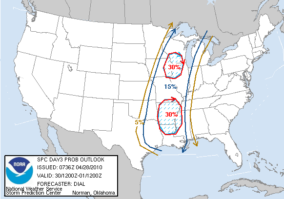
In SPC's early morning update, SPC has removed SE TX from the slight risk for severe weather
However-
http://forums.khou.com/viewtopic.php?f= ... 4710#p4710
However-
http://forums.khou.com/viewtopic.php?f= ... 4710#p4710
-
- Information
-
Who is online
Users browsing this forum: Ahrefs [Bot], Amazon [Bot], Bing [Bot] and 53 guests