

I see what you're looking at but my radar loops show that that little storm has been tagging along with the main cell for about an hour now..weatherguy425 wrote:While I do believe we've seen about all we're going to see, there does appear to be the start of redevelopment just west of the current storm.
April Weather Discussion.
The storm near Brenham is still creating winds near 50mph just above the surface...
NWS will probably cancel current warning before expiration.
Sitting outside of our place near memorial city mall watching the lightning off in the distance.
Not a bad way to spend the evening!
Not a bad way to spend the evening!
SPECIAL WEATHER STATEMENT
NATIONAL WEATHER SERVICE HOUSTON/GALVESTON TX
949 PM CDT MON APR 26 2010
TXZ211-212-270345-
AUSTIN-WALLER-
949 PM CDT MON APR 26 2010
...SIGNIFICANT WEATHER ADVISORY...
AT 942 PM CDT...NATIONAL WEATHER SERVICE DOPPLER RADAR INDICATED A
STRONG THUNDERSTORM 4 MILES SOUTHWEST OF HEMPSTEAD...MOVING SOUTHEAST
AT 30 MPH.
WINDS GREATER THAN 40 MPH...ARE POSSIBLE WITH THIS STORM.
LOCATIONS IN THE PATH OF THIS STORM INCLUDE...MONAVILLE...PRAIRIE
VIEW...PINE ISLAND AND HEMPSTEAD.


I wonder if these storms will end up over Houston assuming we just get the rain only.
I'm wondering how much of the storms will be left by the time they reach downtown.
-
weatherguy425
- Pro Met

- Posts: 830
- Joined: Wed Feb 03, 2010 7:45 pm
- Location: Atlanta, Georgia
- Contact:
Hmm the stuff up between tyler and shreveport is interesting.
These storms are getting lethargic as they approach us.wxdata wrote:I'm wondering how much of the storms will be left by the time they reach downtown.
How did these thunderstorms form?
A passing upper disturbance will north of here, afternoon heating, a slightly unstable atmo, forming along and ahead of a cold front.Ptarmigan wrote:How did these thunderstorms form?
-
weatherguy425
- Pro Met
- Posts: 830
- Joined: Wed Feb 03, 2010 7:45 pm
- Location: Atlanta, Georgia
- Contact:
So what about those storms north of here?
Here is what I find strange. Storms fire in Central Texas, yet they are closer to Mexico than we are, which gives us the inversion cap we have over our area. I wonder how that could happen.wxdata wrote:
A passing upper disturbance will north of here, afternoon heating, a slightly unstable atmo, forming along and ahead of a cold front.
Afternoon heating was just enough to overcome cap, which wasn't as strong as last Friday.Ptarmigan wrote: Here is what I find strange. Storms fire in Central Texas, yet they are closer to Mexico than we are, which gives us the inversion cap we have over our area. I wonder how that could happen.
I am hearing some rain falling. Good to see some rain for a change. 


Interesting line of showers heading toward Houston from the North ( at 1:55am)
Soundings from both the 18z GFS and NAM both show a mostly unstable atmo for Friday afternoon. However the one big difference between the two model is the cap. GFS has a fairly decent one while the NAM has none. The persistence forecasting method would sure favor the GFS.
Ditto to my above msg on the 0z runs, with perhaps a bit less cap coming in on the GFS. Only thing lacking is a good surface trigger here until maybe Sunday (if the GFS is to believed.)
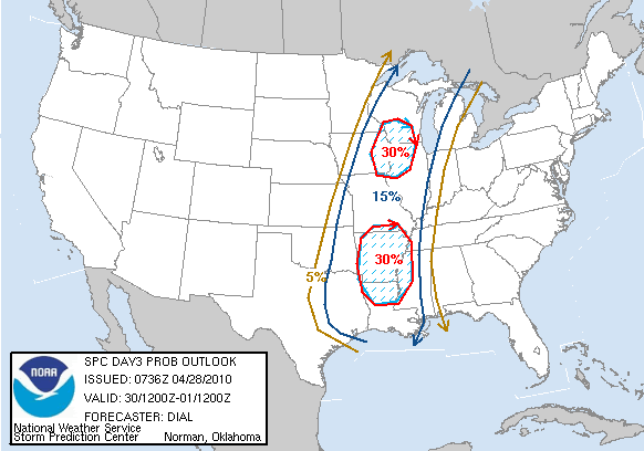
SPC placing SE TX in 'slight risk' for Friday, although once again we're on the southern edge of the risk area...
"...SRN PLAINS THROUGH LOWER MS VALLEY...
A MOIST WARM SECTOR WITH RICH GULF MOISTURE WILL ADVECT NWD THROUGH
THE ERN PORTIONS OF THE SRN PLAINS AND THE LOWER MS VALLEY FRIDAY
BENEATH A MODEST EML PLUME RESULTING IN MODERATE INSTABILITY. MODEL
SOLUTIONS CONTINUE TO DEVELOP CONVECTION WITHIN LOW-LEVEL THETA-E
ADVECTION REGIME IN WARM SECTOR. DETAILS OF HOW STORMS WILL INITIATE
AND EVOLVE REMAIN UNCERTAIN AT THIS POINT...BUT SEVERAL MODES OF
CONVECTION APPEAR LIKELY INCLUDING DISCRETE STORMS AND CLUSTERS.
LARGE HODOGRAPHS ALONG THE LOW LEVEL JET AXIS AND 40-50 KT DEEP
LAYER SHEAR WILL SUPPORT A THREAT OF SUPERCELLS AND TORNADOES AS
WELL AS LARGE HAIL AND DAMAGING WIND. OTHER STORMS WILL LIKELY
DEVELOP ALONG SEWD ADVANCING COLD FRONT. THIS AREA WILL CONTINUE TO
BE MONITORED FOR A POSSIBLE MODERATE RISK IN LATER OUTLOOKS."
http://www.spc.noaa.gov/products/outloo ... 0_prt.html
-
srainhoutx

- Site Admin

- Posts: 19616
- Joined: Tue Feb 02, 2010 2:32 pm
- Location: Maggie Valley, NC
- Contact:
HGX suggests that capping will likey be an issue. We shall see...
Carla/Alicia/Jerry(In The Eye)/Michelle/Charley/Ivan/Dennis/Katrina/Rita/Wilma/Humberto/Ike/Harvey
Member: National Weather Association
Facebook.com/Weather Infinity
Twitter @WeatherInfinity
Member: National Weather Association
Facebook.com/Weather Infinity
Twitter @WeatherInfinity