Page 1 of 45
Re: ENSO Updates
Posted: Thu Feb 16, 2012 3:10 pm
by Ptarmigan
This Week's ENSO
Niño 4 = -0.9ºC
Niño 3.4 = -1.0ºC
Niño 3 = -0.6ºC
Niño 1+2 = -0.4ºC
Average
-0.725ºC or -0.7ºC
Last Week's ENSO
Niño 4 = -1.1ºC
Niño 3.4 = -1.2ºC
Niño 3 = -0.8ºC
Niño 1+2 = -0.7ºC
Average
-0.95ºC or -1.0ºC
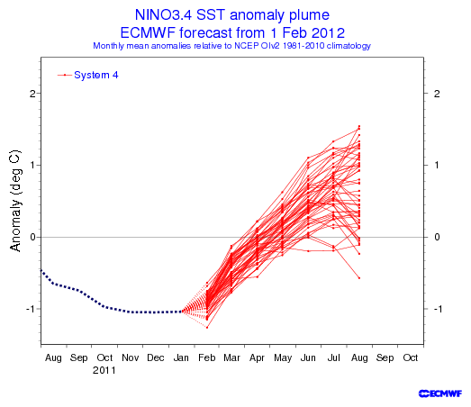
http://www.cpc.ncep.noaa.gov/products/a ... ts-web.pdf
Looks like it is warming up overall. Many forecast models are saying we should be out of La Nina by spring. We may have El Nino by summer or peak season of August to October.

Re: ENSO Updates
Posted: Tue Feb 21, 2012 5:46 pm
by Ptarmigan
This Week's ENSO
Niño 4 = -0.9ºC
Niño 3.4 = -0.6ºC
Niño 3 = -0.1ºC
Niño 1+2 = 0.9ºC
Average
-0.175ºC or -0.2ºC
Last Week's ENSO
Niño 4 = -0.9ºC
Niño 3.4 = -1.0ºC
Niño 3 = -0.6ºC
Niño 1+2 = -0.4ºC
Average
-0.725ºC or -0.7ºC
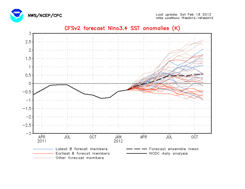
The warming trend is happening as La Nina is fading. Interestingly, Region 1+2 has warmed up considerably and is in El Nino territory.
http://www.cpc.ncep.noaa.gov/products/a ... ts-web.pdf
Most models are now predicting a weak El Nino by July to August. If true, it would be a first time since 2009 to go from La Nina to El Nino. Winters in those years tend to be cold.
Re: ENSO Updates
Posted: Mon Feb 27, 2012 6:58 pm
by Ptarmigan
This Week's ENSO
Niño 4 = -0.7ºC
Niño 3.4 = -0.4ºC
Niño 3 = 0.2ºC
Niño 1+2 = 0.9ºC
Average
0ºC
Last Week's ENSO
Niño 4 = -0.9ºC
Niño 3.4 = -0.6ºC
Niño 3 = -0.1ºC
Niño 1+2 = 0.9ºC
Average
-0.175ºC or -0.2ºC
http://www.cpc.ncep.noaa.gov/products/a ... ts-web.pdf
It is only La Nina in Region 4. The rest is Neutral and 1+2 is El Nino. We are pretty much in Neutral.
Re: ENSO Updates
Posted: Tue Feb 28, 2012 9:51 am
by unome
I didn't read it as being neutral just yet - from the 2/27 pdf:
"• La Niña has peaked across the equatorial Pacific.* Equatorial sea surface temperatures (SST) remain at least 0.5°C below average in the central Pacific, but have warmed considerably across the east-central and eastern Pacific Ocean in the last couple of weeks.
• Atmospheric circulation anomalies remain consistent with La Niña.
• La Niña is expected to transition to ENSO-neutral conditions during March-May 2012.*"
"• The majority of models predict the return of ENSO-neutral (Niño-3.4 SST anomalies between -0.5°C and +0.5°C) during the Northern Hemisphere spring (March-April-May) and continuing through the summer."
Re: ENSO Updates
Posted: Tue Feb 28, 2012 10:23 am
by MontgomeryCoWx
maybe not tropical weather, but El Nino does typically yield wet conditions for Houston
Re: ENSO Updates
Posted: Tue Feb 28, 2012 3:03 pm
by MontgomeryCoWx
yep, I've seen some wild wild swings during Winter El Nino years...
Re: ENSO Updates
Posted: Tue Mar 06, 2012 10:27 pm
by Ptarmigan
This Week's ENSO
Niño 4 = -0.8ºC
Niño 3.4 = -0.5ºC
Niño 3 = 0.4ºC
Niño 1+2 = 1.1ºC
Average
0.05ºC or 0.1ºC
Last Week's ENSO
Niño 4 = -0.7ºC
Niño 3.4 = -0.4ºC
Niño 3 = 0.2ºC
Niño 1+2 = 0.9ºC
Average
0ºC
This is really interesting. Nino 1+2 is warming, while 3.4 and 4 are cooling. Strange.
http://www.cpc.ncep.noaa.gov/products/a ... ts-web.pdf
Re: ENSO Updates
Posted: Tue Mar 06, 2012 10:28 pm
by Ptarmigan
Re: ENSO Updates
Posted: Tue Mar 13, 2012 10:18 pm
by Ptarmigan
This Week's ENSO
Niño 4 = -0.8ºC
Niño 3.4 = -0.6ºC
Niño 3 = -0.2ºC
Niño 1+2 = 0.4ºC
Average
-0.3ºC
Last Week's ENSO
Niño 4 = -0.8ºC
Niño 3.4 = -0.5ºC
Niño 3 = 0.4ºC
Niño 1+2 = 1.1ºC
Average
0.05ºC or 0.1ºC
It is starting to cool again. I think it could be fluctuations.
Re: ENSO Updates
Posted: Fri Mar 16, 2012 10:57 am
by Ptarmigan
IRI Probabilistic ENSO Prediction for NINO3.4 Region by Atlantic peak season.
ASO 2012 12% 54% 34%
A 34% chance that El Nino will develop by then.
By Late Fall and Early Winter
NDJ 2013 8% 51% 41%
A 41% chance that El Nino will develop by then.

 http://iri.columbia.edu/climate/ENSO/cu ... gure3.html
Re: ENSO Updates
Posted: Wed Mar 21, 2012 4:33 pm
by Ptarmigan
This Week's ENSO
Niño 4 = -0.6ºC
Niño 3.4 = -0.6ºC
Niño 3 = -0.4ºC
Niño 1+2 = 0.3ºC
Average
-0.325ºC or -0.3ºC
Last Week's ENSO
Niño 4 = -0.8ºC
Niño 3.4 = -0.6ºC
Niño 3 = -0.2ºC
Niño 1+2 = 0.4ºC
Average
-0.3ºC
Highlights
• La Niña has weakened across the tropical Pacific Ocean.*
• Equatorial sea surface temperatures (SST) remain at least 0.5°C below average in the central Pacific, and near average in the eastern Pacific Ocean.
• Atmospheric circulation anomalies remain largely consistent with La Niña.
• La Niña is expected to transition to ENSO-neutral conditions by the end of April 2012.
http://www.cpc.ncep.noaa.gov/products/a ... ts-web.pdf
Re: ENSO Updates
Posted: Tue Mar 27, 2012 5:51 pm
by Ptarmigan
This Week's ENSO
Niño 4 -0.4ºC
Niño 3.4 -0.5ºC
Niño 3 -0.1ºC
Niño 1+2 0.5ºC
Average
-0.125ºC or -0.1ºC
Last Week's ENSO
Niño 4 = -0.6ºC
Niño 3.4 = -0.6ºC
Niño 3 = -0.4ºC
Niño 1+2 = 0.3ºC
Average
-0.325ºC or -0.3ºC
http://www.cpc.ncep.noaa.gov/products/a ... ts-web.pdf
Re: ENSO Updates
Posted: Tue Mar 27, 2012 5:51 pm
by Ptarmigan
The 2011–12 La Niña reaches its end
http://www.bom.gov.au/climate/enso/
The 2011–12 La Niña event has ended, with key indicators returning to neutral (neither El Niño nor La Niña) levels. Climate models surveyed by the Bureau of Meteorology suggest that neutral conditions will persist until at least early winter.
Key Pacific Ocean indicators are now at neutral levels, with values similar to those last seen in August 2011. Likewise, atmospheric indicators such as cloudiness, trade winds and the Southern Oscillation Index (SOI) have also returned to near-normal values for this time of year. Despite the 2011–12 La Niña not commencing until far later than normal (spring), the decline has been fairly typical of past events, with a peak in January and a return to neutral conditions during autumn.
The demise of the La Niña does not mean the risk of wet conditions (or tropical cyclones) over Australia has ended. While sea surface temperatures around the continent remain warmer than normal and the tropical wet season is active, there remains a risk of above average rainfall over Australia.
The Indian Ocean Dipole (IOD) has limited influence on Australian rainfall from December through to April. Neutral IOD conditions are forecast for the southern hemisphere winter.
Re: ENSO Updates
Posted: Tue Apr 03, 2012 10:52 am
by MontgomeryCoWx
The latest weekly SST departures as of April 2nd are:
Niño 4 -0.5ºC
Niño 3.4 -0.2ºC
Niño 3 0.3ºC
Niño 1+2 0.9ºC
Re: ENSO Updates
Posted: Wed Apr 04, 2012 10:04 pm
by Ptarmigan
Thanks MontgomeryCoWx for posting the latest ENSO data.
This Week's ENSO
Niño 4 -0.5ºC
Niño 3.4 -0.2ºC
Niño 3 0.3ºC
Niño 1+2 0.9ºC
Average
0.125ºC or 0.1ºC
Last Week's ENSO
Niño 4 -0.4ºC
Niño 3.4 -0.5ºC
Niño 3 -0.1ºC
Niño 1+2 0.5ºC
Average
-0.125ºC or -0.1ºC
We are now Neutral.
http://www.cpc.ncep.noaa.gov/products/a ... ts-web.pdf
Re: ENSO Updates
Posted: Thu Apr 05, 2012 10:55 am
by wxman57
Not neutral yet. JFM average was -0.7. Still La Nina:
http://www.cpc.ncep.noaa.gov/products/a ... ears.shtml
The graphic at the Top is the weekly values, which have moved into the neutral range. But it's the 3-month average that determines the status, not the current value. The bottom graphic is a plot I made of the ENSO from 1950-2012 (3 month averages).
Re: ENSO Updates
Posted: Thu Apr 05, 2012 11:02 am
by Ptarmigan
Re: ENSO Updates
Posted: Thu Apr 05, 2012 5:54 pm
by unome
from pg 20 of the latest update:
Oceanic Niño Index (ONI)
•The ONI is based on SST departures from average in the Niño 3.4 region, and is a principal measure for monitoring, assessing, and predicting ENSO.
•Defined as the three-month running-mean SST departures in the Niño 3.4 region. Departures are based on a set of improved homogeneous historical SST analyses (Extended Reconstructed SST – ERSST.v3b). The SST reconstruction methodology is described in Smith et al., 2008, J. Climate, vol. 21, 2283-2296.)
•Used to place current events into a historical perspective
•NOAA’s operational definitions of El Niño and La Niña are keyed to the ONI index.
from NOAAWatch, updated April 5th:

from:
http://www.cpc.ncep.noaa.gov/products/a ... ears.shtml
Jan Feb Mar:
-0.7
Re: ENSO Updates
Posted: Mon Apr 09, 2012 11:36 pm
by Ptarmigan
This Week's ENSO
Niño 4 -0.4ºC
Niño 3.4 -0.3ºC
Niño 3 0.3ºC
Niño 1+2 0.5ºC
Last Week's ENSO
Niño 4 -0.5ºC
Niño 3.4 -0.2ºC
Niño 3 0.3ºC
Niño 1+2 0.9ºC
http://www.cpc.ncep.noaa.gov/products/a ... ts-web.pdf
How the global climate is progressing right now.
Global Ocean Monitoring: Recent Evolution, Current Status, and Predictions
http://www.cpc.ncep.noaa.gov/products/G ... urrent.pdf
Re: ENSO Updates
Posted: Wed Apr 18, 2012 9:24 pm
by Ptarmigan
This Week's ENSO
Niño 4 -0.2ºC
Niño 3.4 -0.3ºC
Niño 3 0.5ºC
Niño 1+2 1.9ºC
Last Week's ENSO
Niño 4 -0.4ºC
Niño 3.4 -0.3ºC
Niño 3 0.3ºC
Niño 1+2 0.5ºC
Trending away from La Nina and likely heading into El Nino.
• A transition from La Niña to ENSO-neutral is underway.
• Equatorial sea surface temperatures (SST) remain near 0.5°C below average in the central Pacific, and above average in the eastern Pacific Ocean.
• Atmospheric circulation anomalies remain mostly consistent with La Niña, but have weakened in recent weeks.
• La Niña is expected to transition to ENSO-neutral conditions during April 2012.
http://www.cpc.ncep.noaa.gov/products/a ... ts-web.pdf

