
January 2026
-
djmike

- Posts: 1876
- Joined: Fri Jan 07, 2011 12:19 pm
- Location: BEAUMONT, TX
- Contact:
Ah I see. I wasn’t looking far enough west. Figured the coastal counties moisture would be around Matagorda or CC by this time. Thanks guys.
Mike
Beaumont, TX
(IH-10 & College Street)
Beaumont, TX
(IH-10 & College Street)
-
LightningBolt
- Posts: 37
- Joined: Mon Jan 15, 2018 7:47 pm
- Location: Central Liberty County
- Contact:
I've seen the Quachitas' effect on SE Texas weather many times but never thought about how the forest plays a part in this. Thank you for the fascinating explanation!DoctorMu wrote: ↑Sat Jan 24, 2026 8:23 pmYep - it's more of a N/S than E/W line now. Some of it is warm nose mixdown. Some is divergence of cold advection.jasons2k wrote: ↑Sat Jan 24, 2026 7:42 pmThey have the bend wrong. It's a much sharper N/S orientation west of Houston. The times for Houston metro should be pretty close, though.MontgomeryCoWx wrote: ↑Sat Jan 24, 2026 7:11 pm
That freeze line arrival is off. We are below or at freezing in our area and it came at 6 pm, not 9 pm.
So, I looked at some wind maps and the polar/arctic air is coming from the Midwest and moving down the plains or the Mississippi River delta. The Ozarks in MO, AR and to some extend the Ouachitas. The shadow has been bugging me a bit, because the Ozark plateau and Ouachitas are 1500 - 2500 feet high at best. The land west of OKC has this level of altitude. Not the rugged obstruction of the Rockies and the Appalachians.
Then, I found a wind energy and terrain map that provide the (now) obvious clue!
So, moving air from a physics standpoint is a fluid and this obeys those rules and even equations. Increased fluid drag would slow advection and could reduce temp drops in the "shadow," at least temporarily.
So the fluid drag of an object or terrain would look like this:
Fd = 1/2 Cd x Ap x rho[density] x v[sqr]
Sorry about the math!
Here, Cd is the coefficient of drag - how rough a surface is. The higher Cd the greater the turbulence and air drag, slowing down the movement.
Ap = the area blocking air movement of the "ruggedness."
The Ozarks are smooth, not rugged, and are a consequence of erosion of part of a plateau
I've attached the map which leads IMO to a surprising answer to this riddle -
As you can see, the Appalachians are riddled with a high Ruggeness Index or obstructions by chains of mountains rising 6500 ft tall. The Rockies have huge obstructions and cause massive turbulence (High Cd and Ap).
Note where high levels of Roughness are (high Cd) which would slow the air. Notice where the roughness of the terrain is low. As an avid map reader and traveloer I know the terrain of everything east of the Rockies pretty well. Note more limited areas of Ruggedness in the Boston Mountains and some of the Ouachitas in AR vs. the Appalacians and Rockies
Where you see high levels of Roughness (which would drag surface air and also contribute to turbulence) are areas of high forestation. The Ozarks and Ouachitas are densely populated with trees as are the Piney Woods. So, the trees are putting a draf on cold advection from the north, especially if the original source of the wind is NNE. The trees make it rough, increasing turbulence and reduction wind speed and advection on the surface.
I should point out that the trees naturally are in areas with greater rainfall and access to gulf moisture. The plains, Mississippi Delta and parts of the Midwest have far fewer trees and forestation.
The windspeed is not surprisingly high in the plains
The cold air after dark should swallow more of east Texas and catch up with areas west, moving the freeze line from west to east.
-
DoctorMu

- Posts: 8048
- Joined: Sun Jun 28, 2015 11:58 am
- Location: College Station
- Contact:
The freezing line is Beeville to NW Harris Co. to Trinity
-
Rip76

- Posts: 2133
- Joined: Mon Feb 15, 2010 12:38 am
- Location: The Woodlands
- Contact:

-
tireman4

- Global Moderator

- Posts: 7140
- Joined: Wed Feb 03, 2010 9:24 pm
- Location: Humble, Texas
- Contact:
Jeff Lindner on Facebook
1-24-26 946pm
Ice being reported on I-10 between the Brazos River and Columbus on bridges and overpasses.
Travel is becoming increasingly dangerous west of Katy. Ice will likely be spreading south into northern Wharton and northern Fort Bend County in the next few hours
1-24-26 946pm
Ice being reported on I-10 between the Brazos River and Columbus on bridges and overpasses.
Travel is becoming increasingly dangerous west of Katy. Ice will likely be spreading south into northern Wharton and northern Fort Bend County in the next few hours
- Attachments
-
- FB_IMG_1769313178237.jpg
- (89.6 KiB) Not downloaded yet
-
Ptarmigan

- Statistical Specialist

- Posts: 4527
- Joined: Wed Feb 03, 2010 7:20 pm
- Contact:
-
jasons2k

- Posts: 6196
- Joined: Thu Feb 04, 2010 12:54 pm
- Location: Imperial Oaks
- Contact:
Down to freezing over in Victoria.
-
tireman4
- Global Moderator
- Posts: 7140
- Joined: Wed Feb 03, 2010 9:24 pm
- Location: Humble, Texas
- Contact:
Jeff Lindner on Facebook
- Attachments
-
- FB_IMG_1769314949494.jpg
- (225.72 KiB) Not downloaded yet
-
- FB_IMG_1769314871901.jpg
- (226.66 KiB) Not downloaded yet
-
Cromagnum
- Posts: 3065
- Joined: Thu Feb 03, 2011 10:42 pm
- Location: Georgetown
- Contact:
Sleet piling up in Georgetown and Austin now.
-
MontgomeryCoWx

- Posts: 2750
- Joined: Wed Dec 14, 2011 4:31 pm
- Location: Weimar, TX
- Contact:
26.8 and the Farm to Market Road we live on is icy!
Team #NeverSummer
-
MontgomeryCoWx
- Posts: 2750
- Joined: Wed Dec 14, 2011 4:31 pm
- Location: Weimar, TX
- Contact:
We have Sleet with freezing rain in Weimar
Bursts of sleet!
Bursts of sleet!
Team #NeverSummer
-
Seantx81
- Posts: 21
- Joined: Wed Oct 10, 2018 7:25 am
- Location: Dickinson
- Contact:
David Paul just said there’s thunder sleet in Austin on the newscast
I keep losing my usernames. Formerly vertigoss/seanatsk.
Survived Ike in Katy, Harvey in Dickinson and Allison in my car.
Survived Ike in Katy, Harvey in Dickinson and Allison in my car.
-
BAY29
- Posts: 31
- Joined: Sat Mar 08, 2025 6:05 pm
- Contact:
that needs to work its way to tomball
-
Stratton20
- Posts: 5827
- Joined: Tue Feb 09, 2021 11:35 pm
- Location: College Station, Texas
- Contact:
34 here, getting close
-
MontgomeryCoWx
- Posts: 2750
- Joined: Wed Dec 14, 2011 4:31 pm
- Location: Weimar, TX
- Contact:
-
jasons2k
- Posts: 6196
- Joined: Thu Feb 04, 2010 12:54 pm
- Location: Imperial Oaks
- Contact:
After a quick drop from 37 to 34, it's been holding at 34 for awhile. I won't last forever before it drops again.
-
BAY29
- Posts: 31
- Joined: Sat Mar 08, 2025 6:05 pm
- Contact:
i think itll be within the next 30 minutes to an hour.
-
jasons2k
- Posts: 6196
- Joined: Thu Feb 04, 2010 12:54 pm
- Location: Imperial Oaks
- Contact:
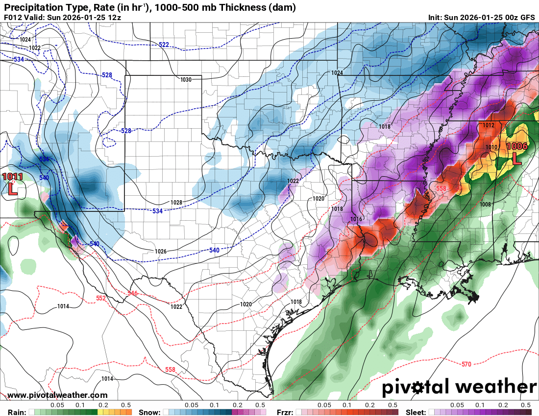
Mesoscale Discussion 0050
NWS Storm Prediction Center Norman OK
1052 PM CST Sat Jan 24 2026
Areas affected...portions of south-central/eastern Texas into western Louisiana
Concerning...Freezing rain
Valid 250452Z - 250845Z
SUMMARY...Mix of freezing rain and sleet likely overnight into early Sunday.
DISCUSSION...Freezing rain and occasional sleet has been ongoing from the San Antonio Metro to College Station, TX. There are reports of freezing rain accumulations around 0.05-0.10 of an inch in 3 hours. Guidance indicates that coverage of precipitation will increase over the next several hours across south-central Texas into western Louisiana as large scale ascent continues to increase.
Forecast RAP soundings depict a warm layer around 850 mb above more shallow sub-freezing air near the surface supporting the primary precipitation type to be freezing rain. HREF guidance indicates increasing probabilities of at least 0.05 of an inch per 3 hr freezing rainfall rates along and north of the I-10 corridor overnight into early Sunday morning. Sleet will remain possible at times in heavier bands, especially with further north extent into the deeper cold air across northeastern Texas.
..Thornton.. 01/25/2026
...Please see www.spc.noaa.gov for graphic product...
ATTN...WFO...LCH...SHV...HGX...FWD...EWX...SJT…
- Attachments
-
- IMG_7479.png
- (2.27 MiB) Not downloaded yet
-
jasons2k
- Posts: 6196
- Joined: Thu Feb 04, 2010 12:54 pm
- Location: Imperial Oaks
- Contact:
It's 34 in Corpus, same as here. That's crazy.
-
gent500
- Posts: 14
- Joined: Thu Feb 03, 2011 7:54 pm
- Contact:
There was a burst of moderate to heavy sleet with lightening and thunder here in south Austin about 30 minutes ago but now it’s back to just freezing rain.